|
What a beautiful start to the day! If you were not up yet, check out this mornings sunrise on our video forecast below or on our Twitter and Facebook. We welcome all your beautiful shots, so tag us on Twitter/Facebook or send them to SecretCityWx@aol.com and we'll share with credit to you. Getting into today's outlook, much colder air lies to the north and will gradually make its way in by Sunday. For now though, mostly cloudy this afternoon and high's in the upper 40's.  Just to the west, a system is set to work in dumping lots of snow to the north and rain to the south. NO winter precipitation is expected here for the valley (on Saturday) but we will feel very cold air by Sunday and early next week. Showers will move out Saturday night with much cooler air working in from the north and west. Keep in mind Sunday will be breezy (10+mph) so even with high's in the lower 40's, feel-like temps could be in the mid 30's. On MLK Day (Monday), high's will just break freezing here in the valley and overnight low's are expected to be in the teens.  Looking at this system in its entirety, a line of showers and embedded storms will arrive late morning/early afternoon and move out by the evening hours. A stray shower or two is possible late overnight tonight, but overall, we will stay dry. Once this system works east, much cooler and drier air will take its place. High's in the 30's will be the main story on Monday and Tuesday with much needed sunny skies overhead.  That concludes today's forecast but enjoy a seasonable day and end to the work week and keep in mind the cold air that is on the way. Have a good weekend!
0 Comments
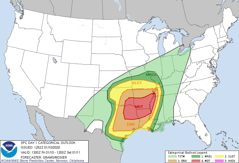
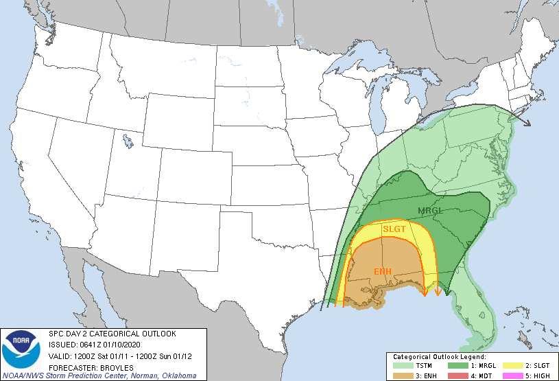
Radar right now shows much of the area dry but scattered showers and storms will move back in this afternoon and evening. Once the last of this system moves through overnight, a cold from will sweep through dropping temps into the upper 40's and lower 50's (Thursday and Friday) 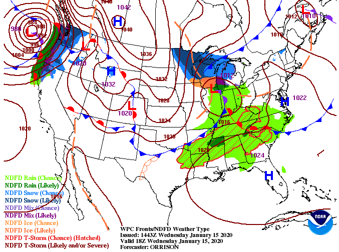 Looking at the latest from the HRRR, rounds of scattered showers are expected this afternoon with stronger showers and storms possible this evening. This system will move out entirely by early Thursday morning, allowing for some peaks of sunshine tomorrow afternoon. Friday will generally be more cloudy as showers will move in overnight. Expect a wet start to the weekend (Saturday) but much cooler and drier by Sunday.  The latest outlook from the CPC has January likely ending slightly below average (temperatures-wise). As winter makes its return, keep those winter coats handy. We are anticipating high's in the 30's early next week with overnight low's in the teens and 20s. 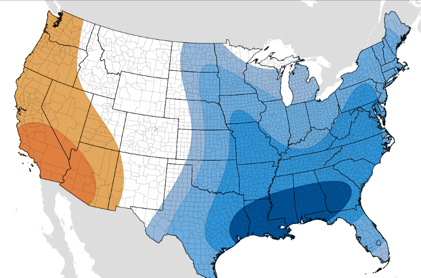 Be weather aware for heavier showers and storms tonight. The SPC has much of east TN under a marginal risk for severe storms (1/5) today. The hazards associated with this risk are: small hail, gusty winds, and heavy downpours. Though confidence is quite low, be aware in case storms do move through a bit stronger. Outside of this evening, don't forget to dress warm tomorrow, high's will be nearly 20 degrees cooler by the afternoon. For the most part, we will stay dry the remainder of today. A few scattered showers can't be ruled out (primarily in the south) , otherwise most cloudy skies will stick around. High's today will be comfortable, once again, in the mid to upper 60's.  Working into Wednesday morning, another round of heavier showers and storms will work through. As discussed yesterday, this won't be an all day rain event, but instead, rounds of scattered showers and storms throughout the day. On Thursday, this system will work out, but only briefly. Friday, shower chances return the later half of the day from a new system to the west and will funnel in heavier showers and storms through the day Saturday.  As you can see from Saturday's anticipated map, heavier showers and storms will work through the day with a cold front on the tail-end. If you have missed winter, this is its return. Cooler and drier air will work in Sunday and early next week with high's back to near and below average. 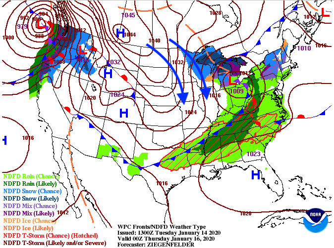 If we take an extended look into the day Sunday, highs will be in the low to mid 40's for the valley. These cooler temperatures will continue into MLK Day and early next week. As promised, look for this cooler pattern to stick around the later half of January and into early February. 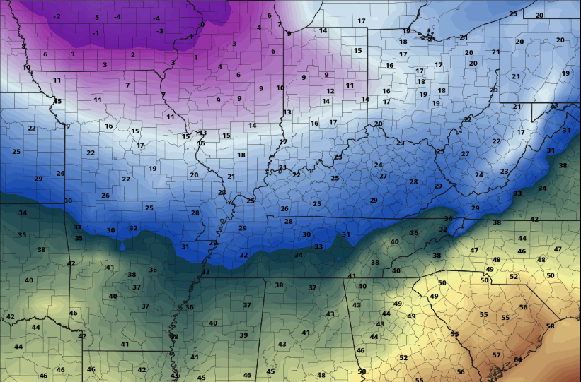 For now, keep those umbrellas handy as more rounds of showers and storms will work in tomorrow. *Reminder: Don't forget to subscribe to this years first annual East Tennessee Almanac created by Secret City Weather. This is a FREE subscription made available at SecretCityWeather.com/Alamanac I hope you are having a good Monday so far! As we push into the PM hours, cloud cover will continue moving in from the south. Seen below, a system to the south will bring in showers and a few storms the next couple of days. 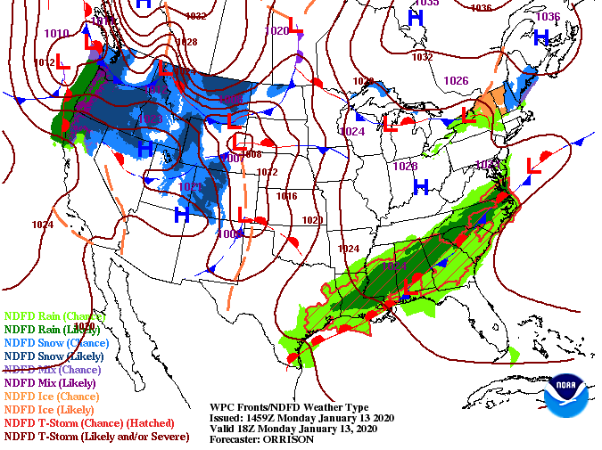 Model guidance precipitation, as well as totals, continue to decrease, but given the latest data expect showers to move in late overnight tonight. This next system will not be a washout filled with day long rain events, but instead, on and off pockets of showers and rumbles of thunder. These scattered showers (and some storms) will eventually push out entirely by Thursday morning.  Though confidence remains low on severe weather, pockets of heavier showers and storms are expected to move through tomorrow morning. The biggest concern will be areas of strong winds but like any severe system, isolated spin-up is possible. To add to a marginal risk (1/5) of severe weather, the timing of the heavier showers/storms comes during the morning commute hours. Be sure to account for wet roads and moderate/heavy rainfall as this will play a roll on traffic speeds.  The main line of this system will stay south leaving upwards of an inch to an inch and a quarter now through Thursday (for the central valley). Earlier models had this system pushing further north, accounting for higher rainfall totals, but model guidance continues to trend downward. If you are to the south (Chattanooga), expect higher amounts up to 3 inches through the day Thursday. 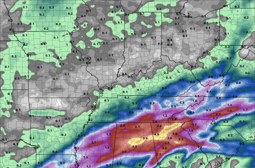 Be careful in the morning hours tomorrow as we are expecting moderate to heavy showers and storms. By the PM hours, showers will be scattered with high's in the mid to upper 60's. Keep the umbrellas handy much of this week; it won't be a washout, but it won't be dry either. Though it may be warm and gloomy here at home, severe weather is likely on the horizon for our friends to the south and west. Looking from left to right (Day 1 to Day 2 SPC outlook) a MODERATE risk encompasses parts of Texas, Arkansas, Louisiana, Alabama, and west Tennessee. With a categorical risk of 4/5, confidence is high that severe weather (damaging winds, heavy rains, and large tornadoes) are possible this afternoon. If you have friends and family in these areas let them know the risks today and that they take the proper precautions to ensure their safety. On the right, SPC day-2 has east TN under a marginal risk (1/5) for Saturday. Even though confidence for severe weather is low, the chance for damaging winds, heavy downpours, and isolated spin-up remains.
Looking at the latest surface map, the powerful system sits just to the south and west providing lots of rainfall for the south and heavy snow storms to the north. This system will work through tomorrow before we clear out Sunday. Enjoy the drier conditions Sunday as more rain arrives early next week. 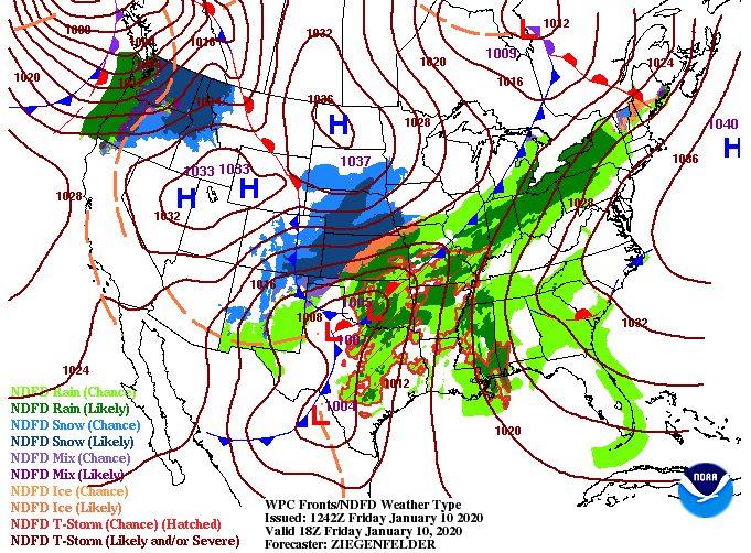 Looking at the highest resolution short-term model offered, scattered showers are possible this afternoon, though for the most part, we will stay dry through much of today. Getting into Saturday, scattered showers and gusty winds (up to 25 mph) continue into the first half of the day before a long line of strong showers and storms works through. The timing of this will fall between 5pm and 8pm. Within this timeframe is our best chance for severe weather. The biggest hazards associated will be damaging winds but isolated spin-up cannot be ruled out. Once this line passes through, cooler and drier air will work in overnight allowing for partly sunny skies on Sunday. 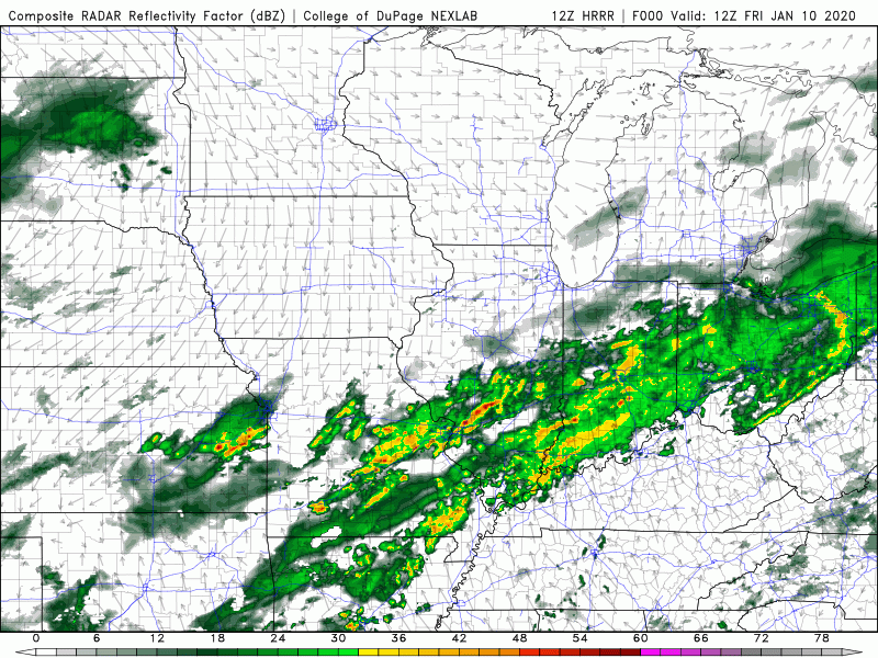 For more analysis on this system, refer to our daily video below. We will be updating you with the latest via social media tomorrow, so be sure to check in and STAY WEATHER AWARE tomorrow afternoon/evening. Have a great weekend! Good afternoon! We started the morning sunny but cloud cover continues to work in from the west, as seen from GOES-East below. A large and powerful system is expected to bring heavy rains, damaging winds, and the possibility of tornadoes to states near the Gulf tomorrow and Saturday.  Showers will begin working in tomorrow afternoon as this system continues to move east. The severe threat for us comes Saturday afternoon with stronger showers and storms arriving on the tail-end of this system. Sunday we will begin clearing back out with partly sunny skies and high's back in the upper 50's.  Taking a look at one of the many models, we will stay dry today before scattered showers work in tomorrow afternoon and overnight. Scattered showers will continue into Saturday before a line of strong to severe storms work through ahead of the front. Expect gusty winds, heavy rains, and the chance for isolated spin up as this system moves through. Once this last "tail" of storms passes, cooler and drier air will work in for Sunday.  Overall rain totals from this system will be between 0.5" and 1". Higher amounts are more likely as you work into both southern and middle Tennessee. For here at home, half an inch to an inch is a safe bet with locally higher amounts possible in heavier cells.  Continue to check back in with us on the latest with this system. We will see gusty winds, heavy rains, and thunderstorms at times, so be weary of the chance of severe weather the second half of the day Saturday. As always though, we will be here to let you know the latest; have a good one! Another gorgeous day today, so I hope you are out enjoying it when you can. If we first jump into the longer-term, the CPC for the middle of January shows above average temperatures continuing for the east coast. I know, like me, many are wanting a big shot of cold air and the chance for some snow. I promise colder air is on the way for late January and into February, we just have to be patient and let winter catch up. 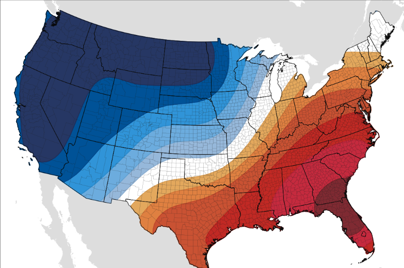 As for right now, ridging continues to take place across the region, meaning sunny skies and warm temperatures stay in tact for Thursday as well. As we get into Friday and Saturday, a system to the west will provide the chance for stronger storms (even some severe storms) to work through before we clear back out on Sunday. 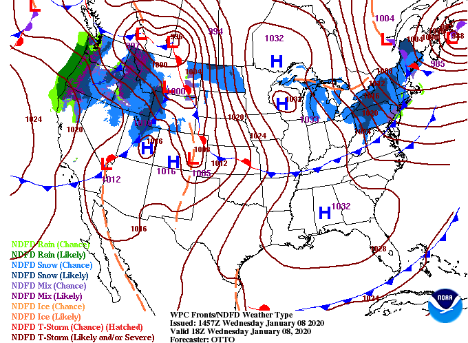 As we saw from the surface map, dry air stays around today and tomorrow. Friday, scattered showers arrive by the afternoon and heavier showers and storms arrive Saturday. As discussed yesterday, timing and the dynamics play a major role for severity here in east TN so continue to check back in. For now, we are on the weakening side of the system (good news) but severe weather (damaging winds, flash flooding potential, and isolated spin-up) can't be ruled out.  We will continue to eye the evolution of this next system as we near the weekend, but until then, enjoy these seasonably warm temperatures and beautiful blue skies. We have cleared up nicely after nearly half an inch of rain (here at the office) fell this morning. Looking into the next couple of days, ridging will dominate much of the east coast, leaving us dry and above average. As we work into Friday and this weekend, a strong system from the south and west will work in, leaving severe weather in question.  Day 5 from the SPC (Storm Prediction Center) shows a 15% chance of severe potential for middle and west TN. From the latest data, storms will arrive in the afternoon and evening hours. Though the SPC gives middle and western TN the best chance for severe weather (Tennessee-wise), I believe severe potential still remains possible for our neck of the woods as well. Inevitably, the timing of initiation and the parameters that make up severe storms will play a roll in the severity here at home. Nonetheless, strong to severe storms (damaging winds & isolated spin-up), heavy rains (1"-3"), and flooding/flash flooding are all possible this weekend. 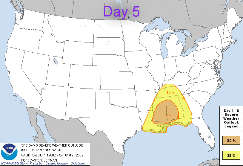 For the time being, we will stay dry with ridging over the eastern USA but showers begin working in Friday. For Saturday, darker shades of yellow, orange, and even reds indicate strong showers and storms throughout Tennessee. As we get closer to time we will have a better idea of the severity and timing, but for now, enjoy the sunny and mild conditions we have the next few days.  With stronger storms moving in this weekend, be sure to check back in for the latest in regard to this system. As we work into Saturday, not only is severe potential on our radar but also the opportunity to beat another high temperature record. The current forecast suggests a high around 70 degrees with the record being 72 (set back in 1890). We will have a beautiful start to the new work week with mostly sunny skies and high's in the low 50's. Shower chances increase overnight tonight, but our next round of showers will be rather quick moving and uneventful. 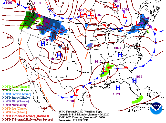 We will stay sunny and dry this afternoon and into the evening hours. Working overnight, showers will begin to work in from the southwest, arriving in east TN between 4-6am and working out, entirely, by the lunch time hours. For the afternoon, expect partly cloudy skies and high's in the upper 40's. We will stay dry mid-week before a larger system arrives Friday & into the weekend.  Overall totals vary throughout east TN, but you can expect around a quarter of an inch in general. The good news is this system will provide light rain early, leaving the remainder of the day dry and mild. 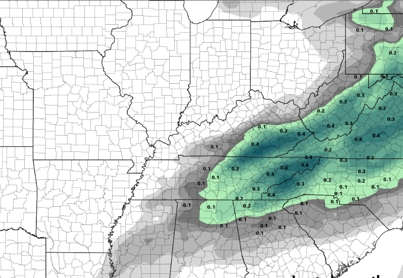 That's all we have for today but enjoy a beautiful start to the new work week. Don't forget to send in your best 2019 pictures and to subscribe to this year's almanac at SecretCityWeather.com/almanac With showers continuing to pour down, here is the latest from the NWS regarding totals. The valley, across the board, is anywhere between 2-3". Here at the office, we have recorded 2.73" as of 11 am this morning. Moving forward, expect an additional quarter to half an inch before it's all said and done with. 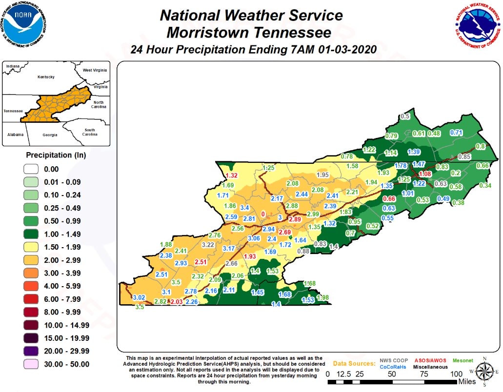 A cold front to the west will begin working in Saturday, decreasing temperatures throughout the day and starting to dry things out. By Sunday afternoon, sunny skies will have returned and cooler air too. High's expected to be back near average in the mid to upper 40's. 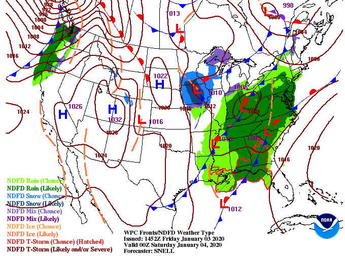 Showers will continue to work through this afternoon before becoming more scattered overnight and early into Saturday. On the back side, we could see some snow flurries but no accumulation is expected in the valley. By Sunday, much needed sunnier skies return. 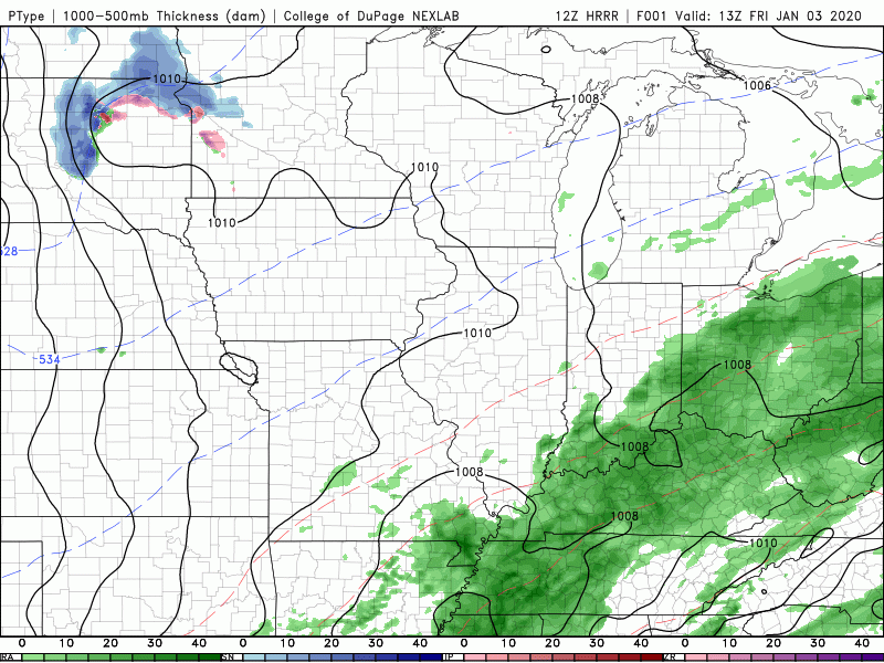 We are still under a Flood Watch until 7 pm tonight, so use caution (especially if you are in a flood prone area). End the work week on a strong note and have a great weekend! |