|
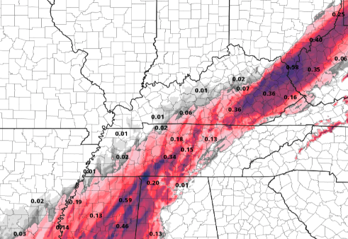
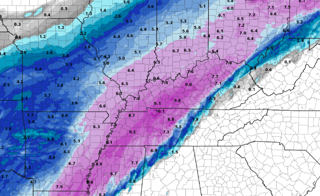
Happy Valentines Day to everyone! We have a messy slate of weather ahead. Current conditions for the valley are cloudy skies and temperatures in the upper 30's. Areas of the Plateau are seeing some light rain & freezing rain conditions. Use caution if you plan to be out on the roadways (in these areas) this afternoon. Slick spots are likely and will continue to worsen overnight tonight through Tuesday morning. A live look from Newfound Gap gives us fog and temperatures in the mid 40's. 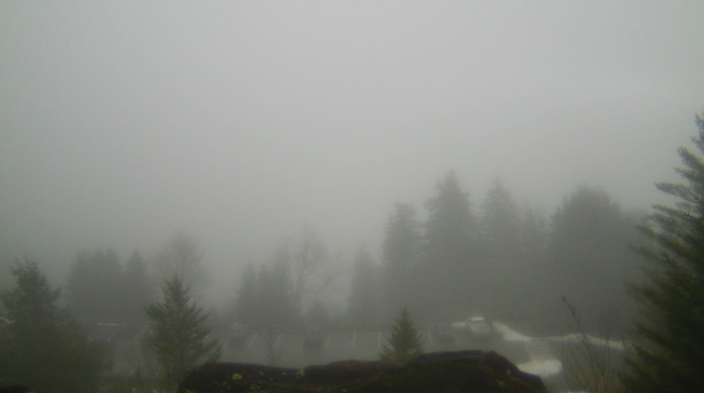 This week will give us several rounds of active weather. For starters, scattered rain to freezing rain will impact the western half of East Tennessee today and early Monday. Areas of concern will be the Plateau and northern East TN. As you can see below, salmon (freezing rain) and purple (sleet) colors dominate much of the concern locations. An Arctic air mass sits to the north and west while a warmer air mass sits across the eastern half of the state. What does this mean early this week? Well in short, a mix of weather conditions. For far Western Tennessee & Kentucky, heavy snowfall is expected tonight through Tuesday. Just to the east, Middle TN and Eastern KY can expect a mix of freezing rain, sleet, and snow. The remainder of us will see mostly rain with mixed precipitation possible. Several rounds impact the region now through Tuesday morning before we briefly dry out Wednesday. This will be followed by yet another wintry system (similar to this one) later in the week.  Breaking this down on a precipitation type basis, you can see the major concern areas. The image on the left depicts freezing rain potential. Freezing rain up to 0.2 inches will be possible overnight tonight and into Monday. Power outages, slick roads, and downed trees will all be a concern. If possible, please stay off roadways and prepare as if power outages are likely. 0.25" of ice can add upwards of 500 pounds to a single stretch of power line. Following the freezing rain to sleet, snowfall moves in the second half of Monday and into Tuesday morning. Snow totals, for our covered areas, will generally be between 1 and 3 inches. Totals increase as you work west. So what about the heart of East Tennessee? We steer clear (for the most part) of hazardous weather. Freezing rain will be something of a concern, but with pavement temperatures on the warm side, this may be challenging (good news). All in all, rain will be the dominate precipitation type for Eastern Tennessee now through Tuesday.
The graphic below highlights areas of watches, warnings, and special weather statements. Colors break down as: Pink: Winter Storm Warning Purple: Winter Weather Advisory Magenta: Ice Storm Warning (Kentucky) 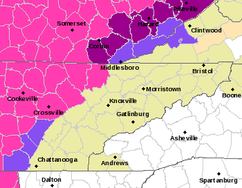 Continue to check in on Twitter & Facebook for the latest updates. The slightest shift could bring very hazardous weather across our neck of the woods. Have a good one, be safe, stay warm, and avoid travel (if possible) to Kentucky and Middle/Western Tennessee.
0 Comments
Good morning! Don't forget those umbrellas through the day as showers will be likely on and off. Looking at end of the day totals, we will generally will range from 3/4 of an inch to one inch. This is good news as abnormally dry conditions still persist throughout the state. (More details below) 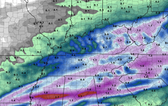 Showers will continue to burden us throughout the day so prepare for a wet one. We could get a few breaks off and on, but generally speaking, showers continue through the afternoon. Overnight, things begin to settle down and dry back out but cloudy skies stick around for Friday. Another system looks to bring rainfall Saturday as the track has moved a bit further west. This time around we could see rain, freezing rain, and mixed precipitation. For now, rain is the main concern Saturday but as temperatures fall near freezing overnight, we could see freezing rain to sleet. We'll continue to provide more updates as we get closer to time.  Abnormally dry conditions continue to haunt the state as we work towards the Spring "fire season". Hopefully these next few rounds of rain bring enough moisture to diminish the present conditions. The next update comes later today, so we'll cover any changes there might be with it tomorrow. 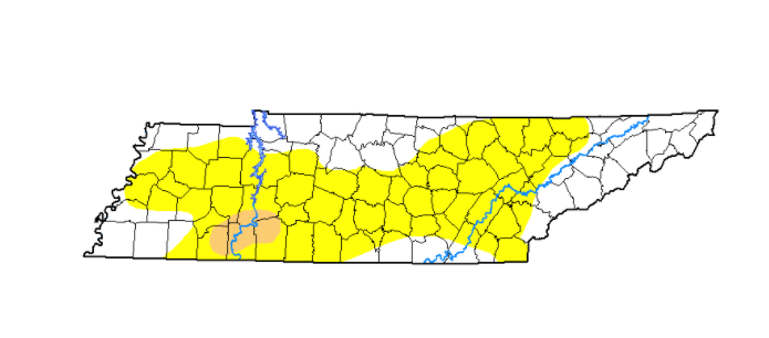 Unsettled weather continues into this weekend so be prepared for updates ahead. For now, stay warm, stay dry, and have a good one! Please consider being a sponsor for this years 2021 Almanac. More information can be found at SecretCityWeather.com/Sponsors Pre-recorded for 5pm show
Happy Hump-Day! Cloud cover continues to hang above with the sight of showers in the not too distant future. In fact, radar has activity to our west, in TN, and to our north in Kentucky. These will continue gliding eastward, arriving by the later part of the afternoon and into the overnight hours. Switching subjects a bit, cold air looks to finally intrude the state. After about a week's bout, things are looking up for you cold lovers mid-February. As an Arctic air mass dips south, we'll see cold air influencing East Tennessee early weekend with high's by Sunday in the 30's for most. A little hint ahead, we could see some winter weather early to mid next week. The latest trends look to bring the chance for an icing to snow event, so something to definitely tune back in for as we gather more details in the coming days. For now, hold tight, stay dry, and warm as we get into the weekend.  Running through the sequence for today and tomorrow, a system from the southwest will push east today. A few sprinkles to light showers ahead of the main system will be possible today, otherwise we will stay cloudy. By this evening, initial moisture will nose in followed by heavier showers (at times) overnight. We could see the potential for some thunder tonight as well, but no severe weather is expected. Showers should continue through the bulk of Thursday (in a west to east orientation) before drying out Friday. As it stands now, East Tennessee will fair on the "good side" of things. Precipitation in the form of all rain is expected for this event.  Unfortunately, our friends just to the west and north aren't so lucky. With cold air at the surface and warm air aloft (in the atmosphere), freezing rain is the likely setup for the areas shaded below. Significant icing is possible Wednesday night through Thursday with totals in the 0.25" to 0.5" ballpark (& locally higher). If possible, avoid travel in these locations on Thursday as power outages, icy roads, and downed trees are all a likely possibility. Nearly all of Kentucky is under an Ice Storm Warning. Trends continue to push this line further south, so fingers crossed we hold on to enough warm air all the way down to the surface. We'll continue to monitor this very closely and give you any updates we may have.  Anticipate, for now, an all rain event with freezing rain a concern for far western-East Tennessee. Rain totals will be upwards of an inch through Thursday will locally higher amounts possible in heavy downpours and thunderstorms. Have a good one, be safe, and continue to check in via Twitter & Facebook for any changes we may have with the forecast. Pre-recorded for 5pm show
Our pattern of unsettled weather begins inching in today. Southern flow will increase temperatures to the mid 50's this afternoon with cloud cover overhead. By this time tomorrow, a system from our west will begin pushing in dumping rainfall by Wednesday night and Thursday. 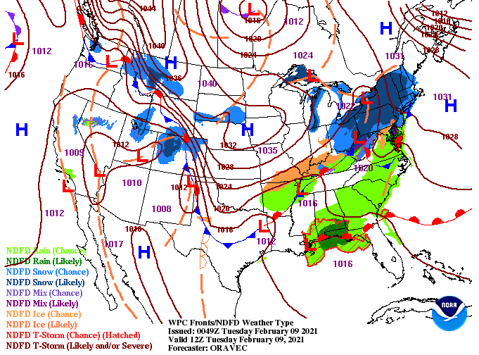 A messy playout is ahead for those to our north in Kentucky. Forewarning now, if you have plans today through Thursday to head through central and northern Kentucky, check the local forecast. Two rounds will bring severe freezing rain potential and the chance for snow. Fortunately for us, the majority of our area will deal with all rain. Getting right into it, showers build in later Wednesday and continue through parts of Thursday. As of now totals range in the 3/4 of an inch to 1.5". Following the rain will be a nice cool down Friday and through the weekend. 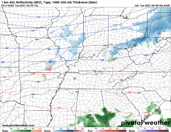 Looking ahead, COLD temperatures sit just to our west. Don't let the negative digits deceive you as these are depicting the change from normal (negative indicating colder than average). As you can see, East Tennessee will be upwards of 15 degrees above average today and Wednesday before colder than average temps find us this weekend.  As we push to complete this years edition, we would like to open up the opportunity for sponsorships. Sizes vary from full down to quarter with premium slots available. If you and/or your company are interested, visit SecretCityWeather.com/Sponsors or click the link below for direct access to our page. We are excited to get this out in the coming weeks!  As always, we appreciate your support! That will wrap it up for today but stay tuned for updates as rain and cooler air are on the way to finish out the week. Pre-recorded for 5pm show
It's a cold Monday start with temperatures across the valley hovering in the low to mid 20's. As we look forward to this afternoon, we'll warm up nicely in the low to mid 50's under sunny skies. Cloud cover does slide in late though as a system to our north shifts east. Looking below, these were the final snow amounts East Tennessee picked up Saturday night into Sunday. Overall, accumulations were pretty on par with the forecast. Some spots across the valley picked up half an inch more than anticipated, but locally higher amounts are always expected. 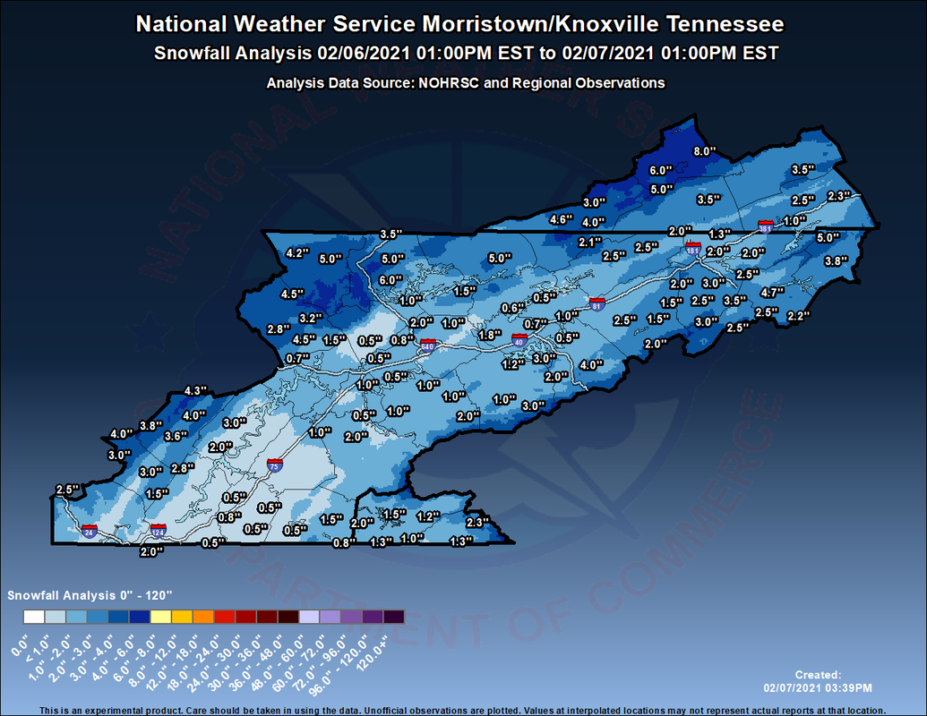 As we saw last week, temperatures will start out the new work week very mild. High's today will top out in the low to mid 50's with Tuesday in the mid to upper 50's. Some areas could even see the low to mid 60's as seen below for Chattanooga. Southern flow will dominate bringing in warm temperatures and moist air. A few isolated showers can't be ruled out for tomorrow, but the majority of us will stay dry and cloudy.  A system lies just to our north and west and will work east through the day today. As it does so, cloud cover will once again be on the increase tonight. Some data does hint at the opportunity for an isolated shower or two Tuesday, but overall, things should stay on the dry side. Towards the middle of the week we will see shower chances return. This next system should arrive the later half of the day Wednesday bringing rain overnight and through Thursday. Cooler air should follow, knocking temperatures back down to average or slightly below.  Satellite gives us the 'all clear' early today, so enjoy the sunshine and mild afternoon high's. If you haven't left the house this morning, be sure to layer up! I would also like to announce The Secret City Weather Almanac is soon on the way. If you would like to be apart of this years addition, check out: SecretCityWeather.com/sponsors Pre-recorded for 5pm show
Showers retreated early this morning allowing for a pleasant morning commute. Working through the day we should see ample sunshine with temperatures topping out in the mid to upper 40's. 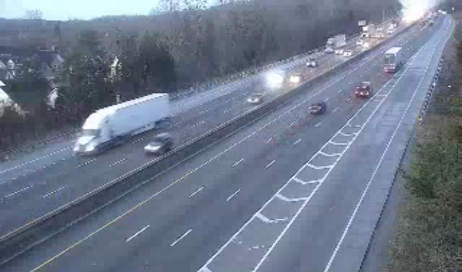 Working ahead, we have lots to discuss. First, snow has been something folks are asking about for this weekend. Breaking this down, a low to our south has shifted a bit further north with its trajectory. This is typically good news as it leaves us in the wake of the cold sector of the low. However, due to insufficient moisture and valley temperatures, I do not expect much in the "snow department". Continue below for more. In reality I anticipate some scattered rain Saturday night into Sunday morning with a chance for a mix in the morning hours. At best, we will see a light coating on grassy surfaces, trees, and stationary vehicles. As Sunday progresses onward, sunshine and seasonable warm temperatures will be about for the afternoon.  Continuing with the snow theme rumored by some, model run one I (image 1) suggests a 7 inch snowfall across the heart of East Tennessee Saturday night. This would be a very rare event to begin with and analyzing the environment Saturday night into Sunday shows insufficient characteristics. In this case, temperatures will hover right around freezing for nearly 2 kilometers (over 6,000 ft) before precipitation reaches the ground. Climatologically and the latest trends for Valley locations, this will likely melt any snowflakes to all rain by the time they reach the ground. If we compare our analysis to "image 2", we find an ensemble forecast (many model runs compiled together). The black line indicates the "mean" or average of the runs. As you can see, the mean lies at a couple tenths of an inch. As mentioned above, the best case scenario will likely be a light coating of snow (a few tenths of an inch). To put this all together short and sweet, my confidence is very low in a "big" snowfall. At best, we will see a light coating of snow before it quickly melts off during the day. The most likely outcome? Scattered rain with some mixing early Sunday morning and then sunshine in the afternoon (no accumulation). The forecast is much more snow oriented for the Smokies as this is an entirely different environment. If you would like more details on this explanation or what the forecast will be for the Smokies, shoot us an email at SecretCityWx@aol.com 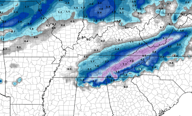 Image 1 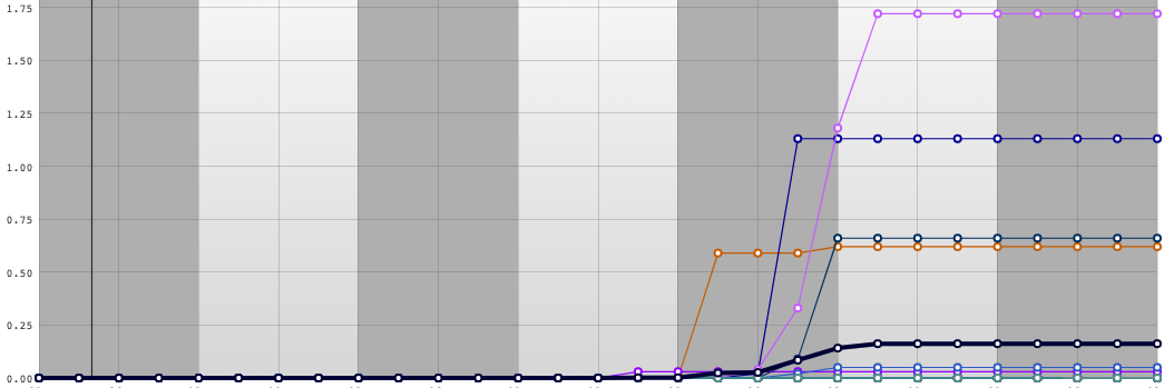 Image 2 To wrap this all up, cold air is still on the way. Assumptions were this swing would arrive early to mid this week but that has been pushed out a few extra days. This pivot in the pattern will bring in the opportunity for extremely cold air late next week. Changes are likely with this so don't hold your breath entirely on the temperatures below, but use them as reference for the chances we could see a week from today. 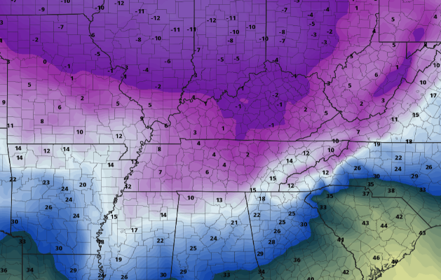 Hopefully you have a sound understanding of what you can expect this weekend and ahead. As someone who enjoys weather, I pride myself on giving the best, most thorough, and easy to read explanation for my viewers (you). Many who just want the weather likely will by-pass much of the explanation for information that will impact them (and that's perfectly fine). We would like to incorporate what you enjoy & gain the most from so please don't hesitate to give us feedback along the way! Again, I apologize for the long post but I hope I covered what's ahead so that you can plan your days accordingly. Have a great weekend! Pre-recorded for 5pm show
We are starting off the morning again chilly with temperatures through the heart of East Tennessee in the upper 20's to low 30's. The good news is temps will again peak in the mid 40's with high's as warm as 50 this weekend.  Continuing on the trend of good news, rain is expected to arrive this evening. How is this good news? Well....Most rain will fall while many are asleep, leaving sunshine to fill back in for Friday afternoon. Showers will be likely early tomorrow morning, which could make the morning commute a bit messy and wet, but we will quickly dry back out. For the weekend, things look mostly peaceful. We will have partly cloudy skies both Saturday and Sunday and high's in the mid to upper 40's.  Working into next week, we continue to trend cold. The cold air will begin to pivot eastward ushering in possibly the coldest temperatures of the year. Earlier data indicated this could arrive as early as Monday/Tuesday but this has since been pushed out a few more days. Nonetheless, next week will likely start mild before ending cold. Our eyes continue to be on any snow potential, but for now that looks very low. 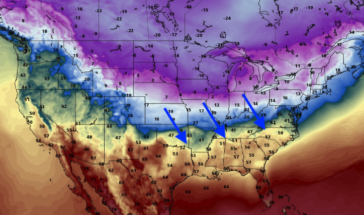 I hope you enjoy your Thursday. Cloud cover will continue increasing through the day but showers shouldn't arrive until sunset or after. A little reminder as well that showers could linger into Friday morning, so be sure to have your umbrellas handy just in case. Pre-recorded for 5pm show
High pressure settles in this afternoon allowing for some much needed warmer temperatures. Most will round out the afternoon with high's near the mid 40's under sunshine. By this evening, cloud cover will again start its return as the next weather maker moves in Thursday evening.  East Tennessee will stay peaceful today and much of tomorrow before moisture returns the later half of Thursday. This next system will carry to our north, again leaving our neck of the woods in the warm sector. What does this mean? Likely all rain. Depending on how quick cold air arrives, we could see some rain/snow mix Friday morning before clearing back out Saturday. Much cooler air is in store late this weekend and throughout much of next week. Analyzing temperatures and wind chills next week, the Climate Prediction Center (CPC) suggests nearly an 80% chance that "feel-like temperatures" will be below 10 degrees sometime between the 7th and 11th. As of now, my confidence is not as high as the CPC suggests. As an Arctic blast of air works through, guidance continues to retreat a bit from the extremely cold (single digit potential) lows. Much, if not all, of next week will hang at to below average with low's varying from the mid teens to low 20's. As this pattern shifts a bit further east, colder temperatures will be in store. We will have to wait and see if this comes to fruition, but for now, anticipate a seasonably cold set of days. Comparatively, it should be similar to what we saw Monday and Tuesday but with cooler overnight lows. 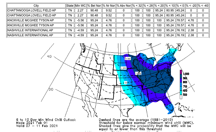 Embrace the sunshine and "warmer" temperatures today before rain and cooler air follow late in the work week and into the weekend. With changes likely next week, be sure to tune back in for your latest forecast! Pre-recorded for 5pm show
We start chilly this morning with a few snow showers/flurries still falling in the far east. As you can see below, Newfound Gap is still getting peppered with snow this morning on top of an already 9" snow depth. As we progress through the day, the parent low that brought snow to East Tennessee will shift north and east with high pressure to fill its place. High's this afternoon will slowly begin to rebound topping out in the upper 30's. That trend continues into Wednesday as well with sunny skies and high's in the mid 40's. 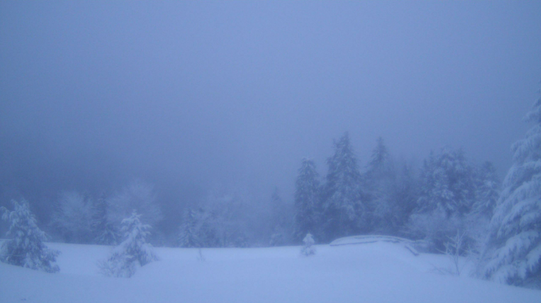 By Wednesday evening, cloud cover will begin gliding back in as a broad pattern change takes place across much of the United States. Shower chances will be on the rise through the day Thursday with rain likely overnight and into Friday. On the tail end of this system, we could see a changeover to snow but lots of uncertainty still remains (discussed some of this yesterday). 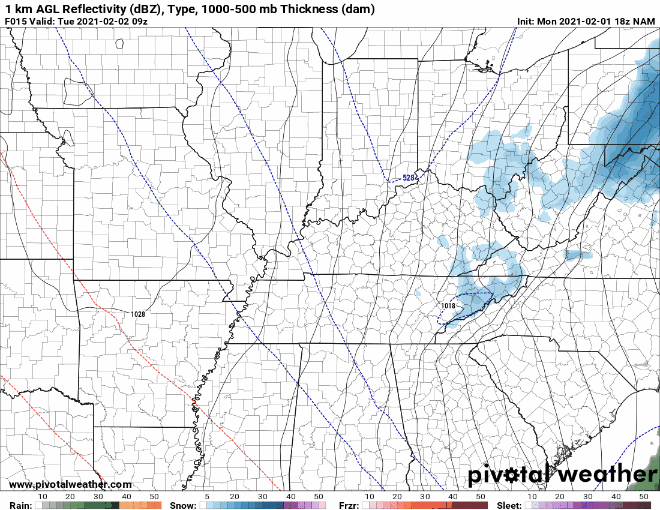 If you recall from yesterday's post, we talked about a system later this week that could bring snow, and at the very least, cold temperatures. Well....the colder air is a guarantee but snowfall (at least for Friday and parts of the weekend) is still up for debate. Looking at temperatures anomalies (the difference in temperature from the mean/average), we see extremely cold air dipping across the deep south early next week. This air could be as cold as 30 degrees BELOW average with some locations seeing even colder results. 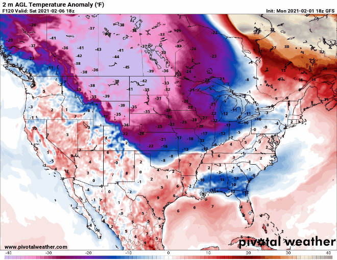 Polar air will take a deep dive through East Tennessee bring us, by far, the coldest temperatures of the year. Most locations will be lucky to find the freezing mark for a high early next week with overnight low's as cold as the single digits. Some locations could even windup seeing negative values. Forecasting for this is still a bit early, but cold air seems pretty definite at this point. Much of next week will be below average with snow chances something we will be analyzing closely. 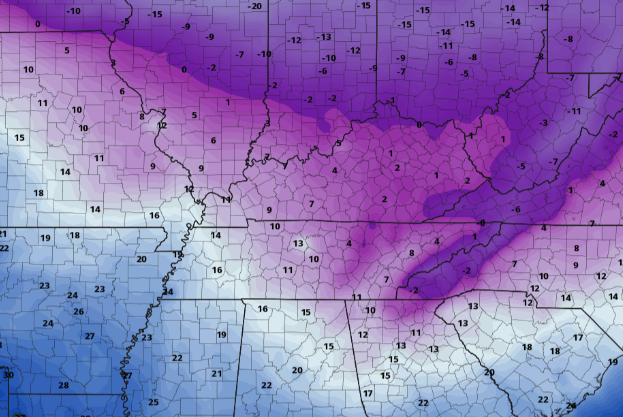 For now, stay warm as today will be yet another chilly one. The good news? Sunshine will creep back in by this afternoon with near average temperatures Wednesday. Have a good one and don't forget to check back in tomorrow for more details later this week and next. Be sure to follow us on Twitter & Facebook (if you haven't already), our username is @SecretCityWx Pre-recorded for 5pm show
Good morning! I hope your day is off to a good start. For those who have not left the house, be sure to throw on an extra coat as temperatures will hang in the 30's all day. Looking at the current TDOT webcam near Hardin Valley, snow showers are working through this morning and will continue to periodically throughout the day. If you follow along on social media, we mentioned accumulations to be light in the valley (dusting to an inch possible) with the Plateau/Foothills (1-3") and the peaks of the Smokies (8-12"+). 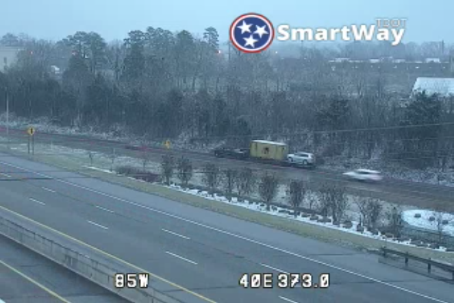 The surface map for this morning paints a messy picture of rain, mix, and snow. As you can see on the webcam above, snow is falling now across the region. As this system works east today, expect clearing and gradually warming temperatures ahead. High's stay cool Tuesday in the upper 30's (near 40) and returning to the mid 40's on Wednesday. 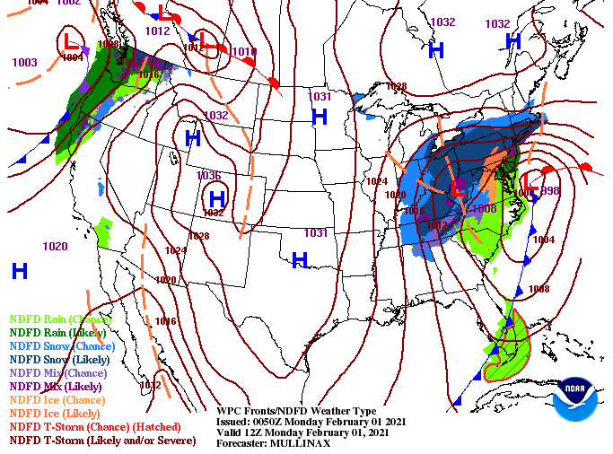 Light snow showers/flurries look to continue on and off today before diminishing this evening. Gradual clearing will take place Tuesday as high pressure works eastward early to mid week. Temperatures will also increase with high's Thursday nearing 50 degrees. Our next system follows late in the work week and early into the weekend....more details below!  Temperatures will feel even colder today with a northwest breeze. Feel-like temperatures will be in the 20's at times so bundle up. Stay safe on roadways as well as slick spots could form. Have a good Monday everyone! Pre-recorded for 5pm show Special Edition: Could We See The Best Of Winter Ahead...?As the title hints to, we could see more snow later this week. Longer term guidance is "hyping" up our next weather maker, arriving first late Thursday. As you can see below, a powerful low will bring the chance for heavy rain, gusty winds, and and some lighting potential. Following this initial line of rain, both GFS and European guidance suggest a changeover to snow across Middle and Eastern Tennessee. As with previous events of these characteristics, I anticipate much lessor amounts...but one can hope right? 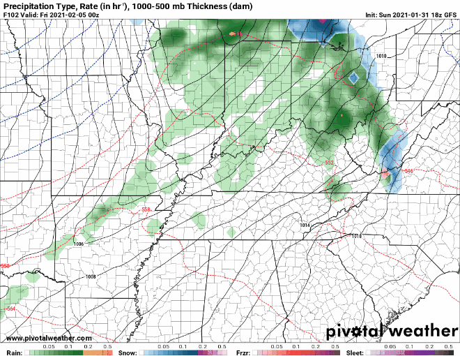 *This is not a forecast* Speaking of accumulations, here are two model outputs for Friday. The figure below is of snow totals over the 36-hour duration. 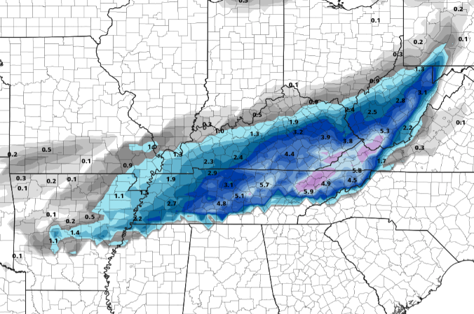 *This is not a forecast* Compare this with the European model below, this is of 6-hour totals. This model is much more bullish, indicating the potential for larger snow amounts. 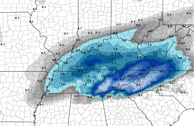 I FULLY anticipate many changes over the next several days but given the 5 to 6 day period, I thought it was noteworthy. Climatological speaking, this would be a very rare event so lean on the side of heavy showers (at times) followed by light snow showers to flurries. For now, if you are a snow lover, do your snow dance for a few days and maybe Mother Nature will bless East Tennessee with a good snowfall. Continue to check in as we'll provide updates ahead. Again, the graphics above are not forecasts, but instead guidance for what could come. We will likely see much less than what is indicated above. Have a good one and stay safe!
|