|
Good afternoon! Showers have worked east providing some much needed drier air. By this afternoon, we should see some spots of sunshine returning and temperatures in the mid to upper 60's. For Wednesday, much of the same. We'll stay dry through the day with high's around 60 degrees. 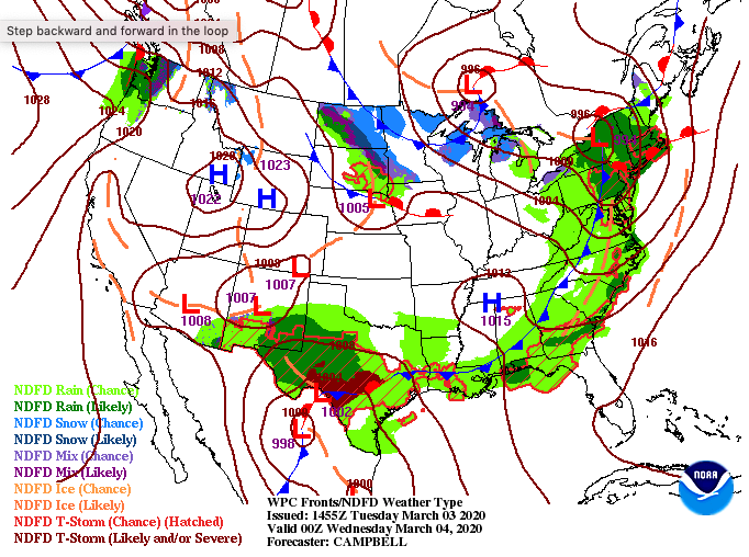 Showers are expected to work back in Thursday morning before cooler and drier air funnels in Friday. The good news is this weekend will be BEAUTIFUL so take full advantage and plan a trip now. Temperatures will be in the 50's to lower 60's with lots of sunshine each day.  Rain totals from this next system will depend on the track of this system and how far north it stretches. The further north it goes, the more rainfall we can anticipate. Given the latest data and the forecast we made yesterday, I expect an additional 1 to 2 inches around the region. As of noon today we have picked up nearly 2" of rainfall (from today & yesterday) at the office with stations in Knoxville and surrounding areas around 1.5". Before the week is out I'm still expecting totals between 3-4" for much of the area. 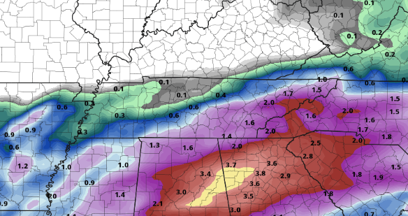 If you haven't heard already, numerous tornadoes touchdowns occurred in Nashville early this morning. As of now, reports of 19+ fatalities, 150+ injuries, and millions in damages are being reported. Be sure to keep Nashville and the surrounding area in your thoughts and prayers this week. Severe weather (watches & warnings) isn't something to be taken lightly and it is unfortunate this occurred so early in the morning when many are asleep.
0 Comments
A low pressure system to the south and west will continue to pull in moisture from the Gulf this afternoon. As we work into tomorrow, a warm front will work through cranking up temperatures. Along with the warm front, heavier pockets of showers and thunderstorms are likely. The timing for these heavier showers/storms falls in the morning hours and then again into the early afternoon. Severe potential remains low, but be careful nonetheless. 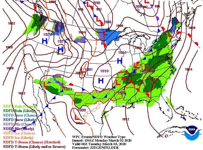 With the warm front moving through tomorrow, temperatures will be seasonably warm in the upper 60's, near 70 degrees. It would not surprise me to hit 70 degrees here in the Valley (especially southern valley) tomorrow afternoon.  Looking ahead, showers will become more scattered this afternoon. Another round of showers and storms work in tomorrow with the warm front before drier air arrives in the evening. That will allow for a mostly dry Wednesday with broken cloud cover. Enjoy this brief reprieve while it lasts, we'll have more rain for Thursday. By Friday afternoon, sunnier skies return with this to continue into the weekend.  So far today we have picked up just over 3/4 of an inch here at the office with another few tenths likely throughout this afternoon. Looking at the latest data, an additional 2 inches is likely now through Thursday afternoon, rounding us off between 3 and 4 inches in total. The good news is flooding potential is on the lower confidence end of things this week, but watch out if you're in flood prone areas. Heavier showers and storms tomorrow and Thursday could lead to quickly rising waters in some spots. 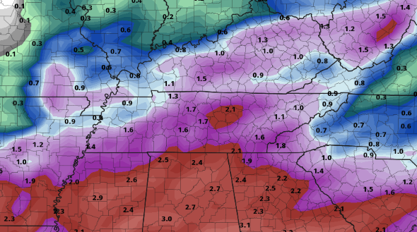 All in all, it's going to be a soggy week with temperatures staying near average. If you can make it through the next couple of days, this weekend looks to be beautiful with sunny skies and high's in the 50's to low 60's. We will continue to monitor any severe threats as we work overnight and into Tuesday morning. |