|
Pre-recorded for 5pm weather broadcast
2 Comments
Good afternoon! Much warmer air has filtered in today as depicted below from the 24-hour temperature change map. High pressure is inching off the east coast, allowing for warm and most air to advect in off the Gulf of Mexico. Highs today will climb to near (or slightly above) average, in the low to mid 60s. An area of low pressure is expected to build across the Great Lakes tonight, where a cold front will sag south of the feature and meander east through Friday. 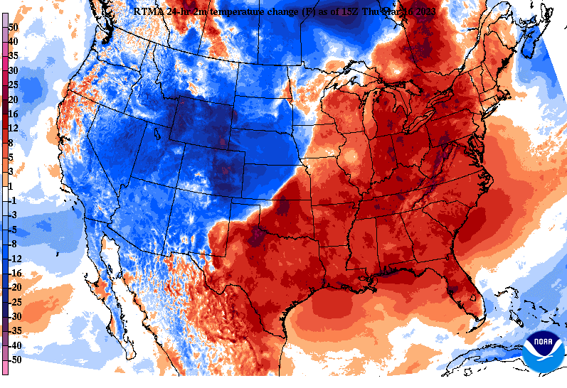 Looking at model guidance, showers will build in late overnight/early Friday and continue into the heart of the day. A few thunderstorms will be possible as well, where locally heavier rainfall amounts are possible. Overall, we are talking about between 0.5"-1" tonight through tomorrow, before cooler and drier air prevails. This will likely be our last good shot of rainfall for some time. 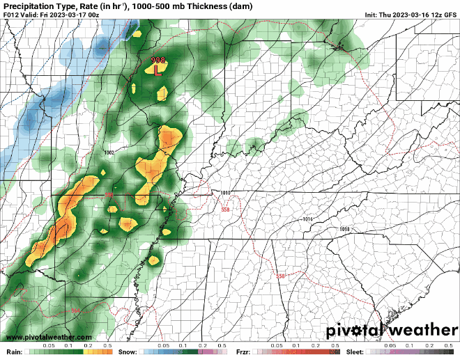 After the passage of the front tomorrow, much cooler air will filter in for the weekend. Temperatures will dip down below average Saturday and Sunday, where highs only find the 40s to near 50 both days. Fortunately, these will moderate into next week, recovering to the 50s and even 60s towards mid week. Have a look at our video forecast below for more details. Pre-recorded for 5pm weather broadcast
A beautiful but cool day is in the making for the Volunteer State as sunny skies will round out our afternoon. Looking below, temperatures, though it may not feel like it, are warming compared to this time yesterday. Many saw highs in the 40s Tuesday and we should warm to highs in the low to mid 50s. Even warmer conditions, near our usual average, will find us in for Thursday.  In addition to the warmer temperatures, we will also see an uptick in moisture, and thus, cloud cover. As a low pressure system tracks east, its cold front south will take aim at the area. Showers will result, with isolated chances beginning Thursday night. The bulk of activity will come Friday, with a few thunderstorms also not ruled out through the day. Overall, this should be a one day hit, before drier and much cooler air filters back in this weekend.  In terms of rainfall amounts, the bulk of precipitation will stay south. That said, you can expect between 0.5-1" Friday. Within any thunderstorms locally higher amounts are likely. The best potential for this will be across the southern valley, nearer to Georgia and Alabama. 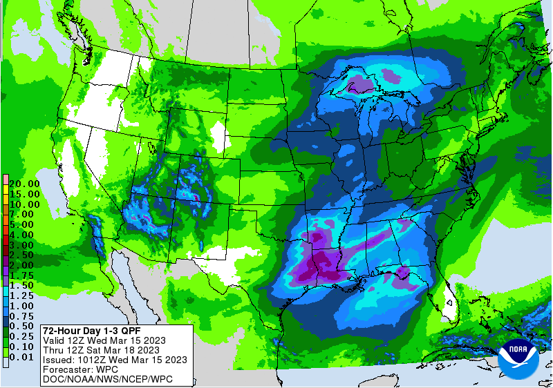 Over the next week the pattern generally stays the same: below average temperatures & brief periods of rain chances. After our shot of rain Friday, we cool back down into the 40s this weekend and stay dry through at least early next week. A system has the chance to bring another round Tuesday, but time will tell on the exact track and impacts as it works along the coastline. Until then, enjoy the warmer temperatures and some sunshine tomorrow before showers return Friday. Pre-recorded for 5pm weather broadcast
Pre-recorded for 5pm weather broadcast
Pre-recorded for 5pm weather broadcast
Pre-recorded for 5pm weather broadcast
Pre-recorded for 5pm weather broadcast
A beautiful start from the TDOT SmartWay cam along I-40 this morning. Temperatures for many sit in the mild mid 50s with highs to warm near the 70 mark this afternoon. That said, cooler temperatures are coming, so break out that cooler gear.  We will stay dry today and tomorrow as a cold Canadian high sits in control well to our north. During this time, a low pressure system will develop across the west, shifting east and arriving to the Ohio Valley by late Thursday. This will lead to isolated showers Thursday, with the bulk of activity overnight and into Friday. Similarly, a passing cold front will lead to much cooler air for the weekend, where another system could bring precipitation chances Sunday and into early next week. There remains quite a bit of uncertainty with this later system, so will keep a close eye on how things evolve moving forward.  In terms of temperatures, cooler air is coming. In fact, highs tomorrow (Wednesday) are expected to top out in the mid and upper 50s. That will be a 10 to 15 degree swing from what we see today. Additionally, a cold front Friday will lead to chilly weekend temperatures. Looking below, Sunday highs could be as cold as the mid and upper 40s. We will wait and see how strong the cold air advection regime ends up being, but this is all to say below average is anticipated Sunday and into early next week. 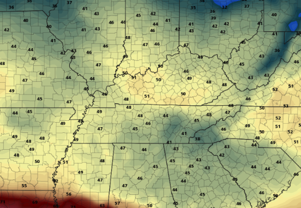 Enjoy our last bit of sunshine and warmth today, as cloud cover and cooler temperatures return Wednesday. Fortunately, we will hold off from seeing showers until later in the day Thursday and through Friday. Have a good one and don't forget to check out our video forecast below. Pre-recorded for 5pm weather broadcast
Good morning! Sunshine is slowly overspreading the Smokies this morning as depicted from the Newfound Gap (6:30 am). Take advantage of that sunshine today as it'll be another pleasant one. We will see increased high clouds this afternoon, but otherwise, partly cloudy with highs in the low 70s. 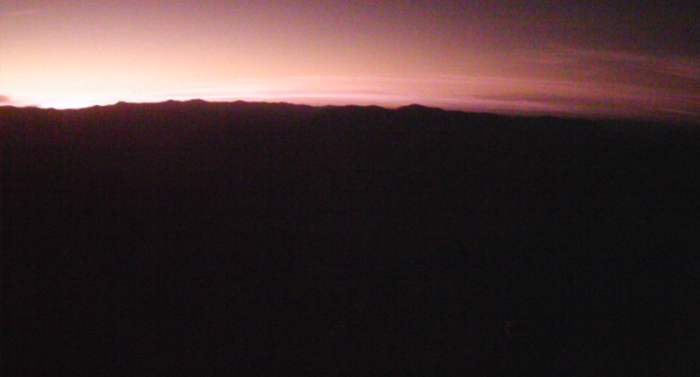 Moving ahead, several disturbances will bring rainfall potential. Up first will be a passing low tonight, which will increase sky cover but things stay dry. That said, cooler temperatures will trail the frontal boundary, where highs tomorrow top out in the upper 60s to low 70s following upper 50s to low 60s on Wednesday. By Thursday, a passing low pressure system will bring showers and isolated storms Wednesday night into Thursday, with the best chances Thursday into Friday. Much cooler air will then follow the later system (as discussed further below). In terms of rainfall over the next 7 days, we are learning to between 1-2". Within any thunderstorms you can expect locally higher amounts, but generally 1-2" will be a good range now through the weekend. 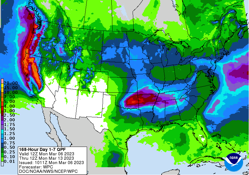 Green thumbs and agriculture folks BEWARE. A pattern shift is coming very soon and its going to lead to some cold March temperatures. We mentioned the dry cold front passing tomorrow and this will push highs into the 50s and low 60s Wednesday. The system late week will further cool things, where highs this weekend only top out in the low to mid 50s. The trend looks to continue ahead for much of March, so much so that some could even see a few late season snowflakes at some point. For now, be aware that much cooler temperatures are on the way and it's a safe bet to hold off from planting. We could even find highs in the 40s across the area over the next 10 days. I know it may feel as if Spring is here but it's not quite yet. 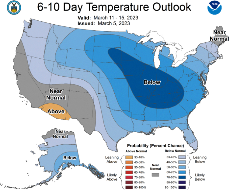 Enjoy another beautiful day today, where highs soar into the 60s and low 70s. Similar conditions are set for tomorrow, before we veer much cooler and have the chance for showers return to East Tennessee. Pre-recorded for 5pm weather broadcast
|