|
What a beautiful view overlooking the Newfound Gap area this afternoon! Sunny skies will be around in full force once again today with high's in the low to mid 60's. 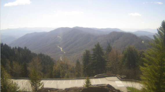 A high pressure system, sitting over much of the eastern US, can be thanked for this pleasant weather. As we end the work week tomorrow, sunny skies stick around early. A system to the west will slide through Friday night and Saturday morning providing shower activity to the area. 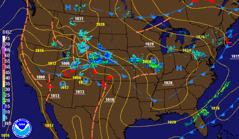 For those that have work early or have some outdoor plans tomorrow morning, bundle up! Temperatures will be a bit warmer than the past few days but still below average. 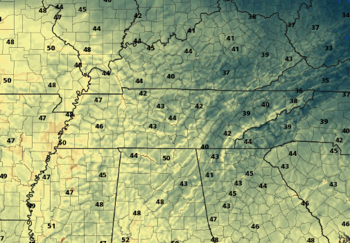 Another beautiful day is in the works for tomorrow with temperatures around 70 degrees. Some cloud cover will begin working in by the afternoon with showers eventually following overnight. Scattered light showers are expected to move out by early Saturday afternoon leaving cloudy skies to finish the day. Again into Sunday, shower activity works in and continues into Monday morning. By Monday afternoon, we'll dry out with a mix of sunshine working in. The weekend total won't be that impressive with totals up to 3/4 of an inch for both days.  That does it for today but enjoy some outdoor time! Temperatures will slowly climb back to average tomorrow before showers arrive into the weekend.
0 Comments
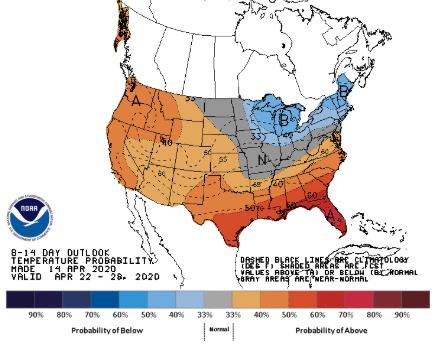
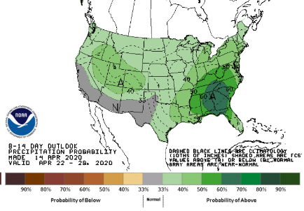
A beautiful day is unfolding with clear blue skies above. Temperatures will remain chilly near 60, but lots of sunshine will make things feel a little warmer than they are. For the present conditions, a high pressure system can be thanked for this fair weather. Expect similar conditions the next couple of days before showers find their way back in this weekend. 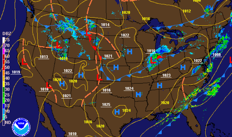 As indicated above, little activity is expected the next few days. Temperatures will gradually warm with the 70's returning on Friday. By Friday night, the next rain maker arrives. Scattered showers will work through much of the weekend before clearer weather again returns early next week.  Longer term looks to be normal, temperature-wise, with average to slightly above average temperatures to close out April. The same cannot be said for precipitation, as above average precipitation is more than likely. The latest data suggests lots of rainfall & even storm activity around the 23rd. Again this is numerous days out and many changes are likely. As for now, enjoy the sunshine and warming temperatures in the coming days.
If you have any tender plants or crops, cover them tonight! Low's will be back down in the mid 30's (for the valley) with freezing temperatures in the higher elevations. Patchy frost is likely to develop for the valley with sub-freezing temperatures for those in the northern Valley, Plateau, and Smokies. A chilly start in the upper 30's to lower 40's has opened up to blue skies. Just to our west, currently working through western TN, cloud cover is making its return. A slight chance for a shower presents itself overnight, otherwise expect to stay dry and chilly with low's in the mid 30's. 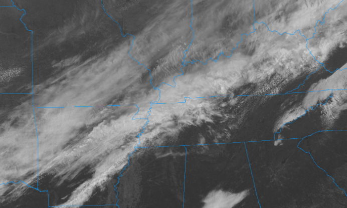 A high pressure system will build in Wednesday, gradually warming things up in the days ahead. Sunny skies will also accompany the next few days before another system works in late Friday and through the weekend. High's will remain cool Wednesday, in the upper 50's, but the 70's will return for Friday. 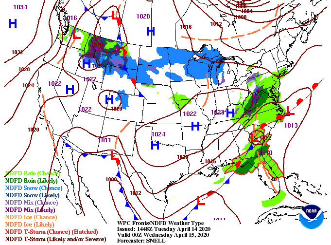 We put an isolated chance for a shower in the forecast, but frankly, the majority of us won't see any rain. Limited moisture is associated and model guidance indicates any shower activity will be limited to the northern valley/plateau and into Kentucky. Working into Wednesday morning, again a cold start, we will clear out with sunny skies by the afternoon. Warming temperatures and sunny skies will follow for Thursday and Friday.  With a calmer set of days ahead, enjoy the sunshine and cooler temperatures. We will be back to average on Friday before shower chances work back into the region. The unfortunate event of severe weather struck late last night to parts of Ole' Rocky Top. The SPC storm reports (below) show the extent of damage across the southeast. Hail and wind damage run from northern Texas to the Carolinas and Virginia's. In total, over 700 storm reports were accounted for, including 64 tornado reports. To clarify, this does not mean 64 individual tornadoes formed yesterday, but instead, that 64 reports were made about witnessing a tornado. 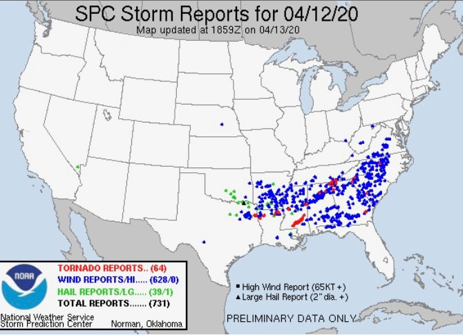 A reporter for WTVC in Chattanooga tweeted the Chattanooga Fire-department stated downtown Ootewah was a "disaster" minutes after a tornado was believed to sweep through the area. 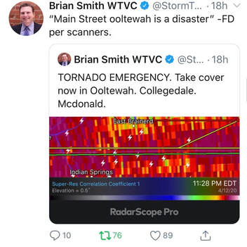 These reports continue with numerous outlets tweeting about damages, power outages, downed trees, structures, and more. The fire department and police department even reported going door to door to make sure every person was safe and accounted for.  Long after the tornado reports (notice 1:52 am) crews and officials urged residents to remain indoors. Many reported loss of power, emergency situations, and the overload of phone calls to 911 outlets. 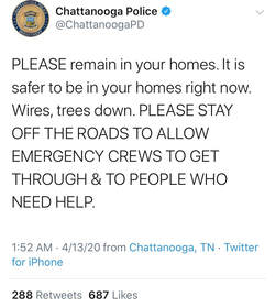 For a full summary, given the data we recorded and reported, view our update below. The imagery isn't the best but it definitely paints a clear picture that this tornado was significant and moved through numerous towns east of Chattanooga. If you have any questions, comments, or are interested in our services, email us at SecretCityWx@aol.com. An update from the NWS: "Storm survey has found EF-3 damage with winds estimated around 145 mph. Storm survey is still ongoing with updates as they come in." As that information comes in, we'll post this evening with more details and share some of the data we recorded last night. Jumping into today though, cooler air is working in. A cold front (as seen below) is heading east this afternoon. Expect below average temperatures for the first half of the week with warmer temps Thursday and Friday.  There's little activity around the region right now but a chance for scattered showers presents itself tomorrow night. Following this brief shower, a high pressure system will build in providing sunshine and warming temperatures. 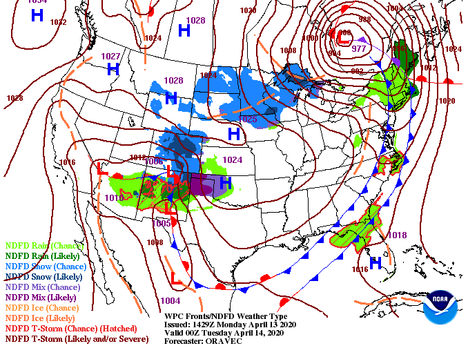 A glimpse into the showers tomorrow shows they will be limited and scattered in nature. Not everyone will get wet and this will be quick moving. Following tomorrow night, clearer skies will arrive for Wednesday afternoon and the days to follow.  Check in for a second post this evening with updates on the Chattanooga tornado and to see some of the data & analysis from last night. All eyes are set for the later half of the day tomorrow as rounds of heavy showers & storms are likely to work through. Check out the video below for a more in-detail look but here are some of the highlights: - A Flash Flood Watch in effect for the entire area tomorrow - Damaging winds, hail, and flash flooding near the high range - Tornado threat in the medium range - Timing is expected to be between 8 pm and midnight. Heavier showers and storms are likely before and after but the best window for severe weather is during this time With cooler air working in today, Freeze Warnings have been placed for tonight. The main concern is for Anderson County and to the north. Though the NWS doesn't include the valley, overnight low's are likely to be near that freezing mark. Protect any sensitive plants you may have as frost and freezing temperatures are likely. 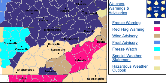 Looking at the latest across the country, not to much is going on locally. A high pressure system will keep things dry and peaceful today and tomorrow before big changes into Easter. 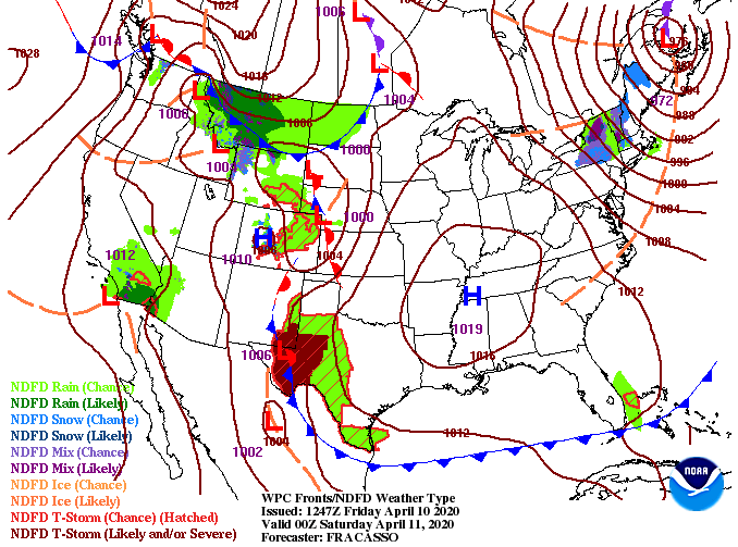 The SPC day 3 outlook (For Easter Day) has changed quite drastically since yesterdays release. Many factors for severe weather are in place and the likelihood for catastrophic damage late this weekend is something on many meteorologists minds. 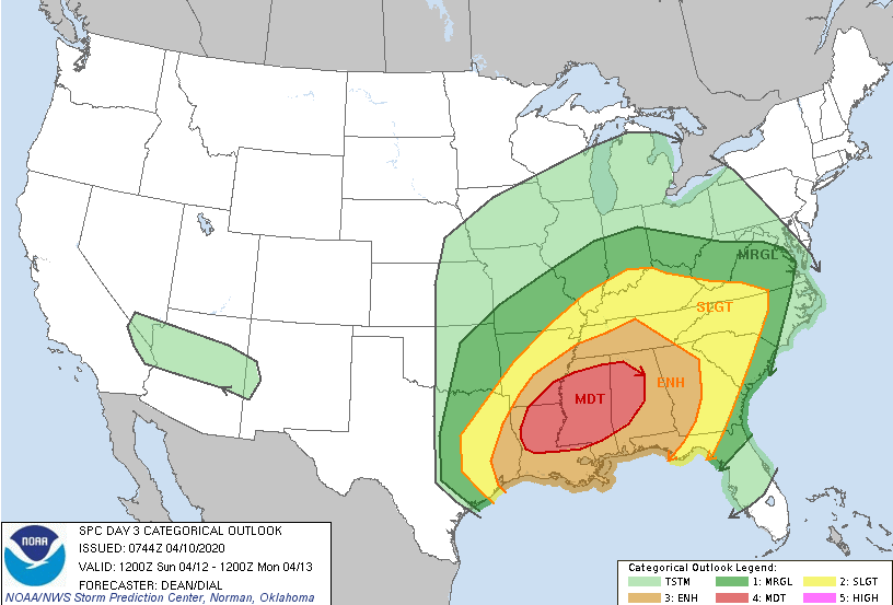 For a "play by play" rehearsal, a low pressure system will develop in Texas and work north and east. With a strong, warm, and moist subtropical jet as support and a cold pool to the west, lots of instability is in place for Sunday. The latest data continues to push this system further north, the reason we've now been included in the severe outlooks. Timing: Showers will begin working in Sunday morning with heavier showers and storms by the afternoon and evening. The biggest threat (as of now*) comes after 2pm Sunday. This line is capable of producing damaging winds, large hail, and isolated tornadoes. With this system being several days out, changes are likely occur so check in for updates. If you have friends/family in parts of Alabama, Mississippi, Arkansas, and Louisiana, make sure they know the threats for Sunday.  The table below give a brief description of what each categorical risk means. Most of east TN (as of today) is under a slight risk but Chattanooga and southern middle TN are under an enhanced risk. Be weary of the changes that are likely to occur over the next couple of days. 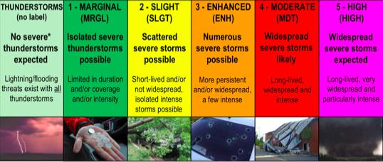 It is very unfortunate that this system will work in on a major holiday, but given the stay at home orders nation-wide, it could help in saving lives. Given this system is 3 days out, we'll continue to monitor the track, impacts, and timing for us East Tennesseeans. Enjoy the sunshine and warming temperatures as we work into Saturday and be weather aware on Easter. Just when you think summer is on its way, early Spring to late Winter returns. High's this afternoon will remain comfortable in the mid 60's but much cooler air arrives tomorrow with high's in the mid 50's. To put this in to perspective, the average for early to mid April is the upper 60's. That means we'll be nearly 15 degrees below average tomorrow. The good news is a high pressure system is overhead, keeping things dry and sunny the next couple of days. 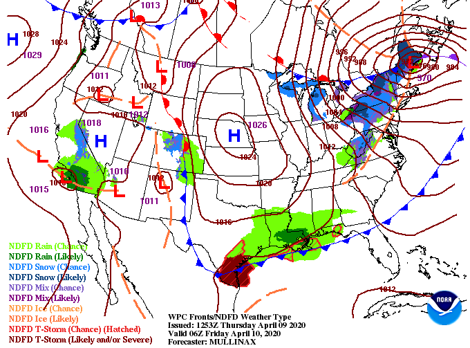 Looking at those temperatures tomorrow afternoon, many will struggle to see 60 degrees, even to our south. Overnight low's will be in the low to mid 30's and frost looks to be an issue Friday night into Saturday morning. Clear skies overnight will only make things cooler as clouds typically hold in some of that warmth (kind of like a blanket).  The next couple of days will be cool but rather peaceful. As we enter in Easter weekend, shower activity begins to ramp back up. Clouds cover will build Saturday afternoon as showers work in overnight and through Easter Sunday. The severe threat (as seen below on our video forecast) will stay contained mostly to the south. A few stronger showers or storms can't be ruled out so we will keep a close eye on this next system over the next few days. 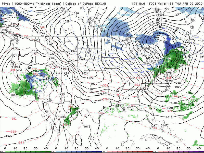 Bundle up! If you are like me, you were just getting used to the 70's across the area. Cooler air will work in tomorrow with warmer temps into the weekend. The trend still looks promising for cooler air in mid-April so we haven't activated 'Summer' just yet. All eyes are set on tonight as much of the region is under an 'enhanced' risk for severe storms. As indicated by the NWS below, the primary threats will be damaging winds (60-80 mph), large hail, and frequent cloud to ground lightning. Secondary threats include isolated tornadoes. 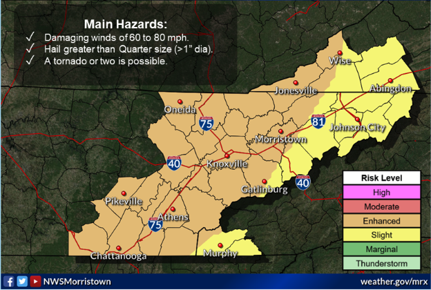 The low pressure system in the Great Lakes region is parent to the cold front extended to its south. This is what we will be eyeing as we work overnight. Storms will begin kicking off after sunset to our north and west (ahead of the cold front) and work in a southeasterly direction. 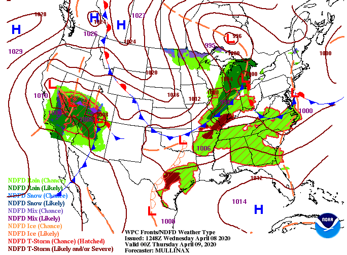 As you can see from model guidance, little activity is expected this afternoon. For the most part, we will stay dry with a mix of sunshine and a few clouds throughout the area. As we work into the evening hours, storms will begin firing up in western Kentucky and working toward the east. With the given data, I believe the biggest threat will be for those in western Kentucky and Western Tennessee. As this bowing structure moves east it will gradually die down overnight. This isn't to say we won't see severe activity through the area but instead to say things look a little better at home than to our west. The timing of this line falls between 2am and 6am; unfortunately when many are asleep. I will emphasize having a way to receive alerts and taking the proper precautions. As we saw with our most recent storms (occurring overnight as well) straight line winds are capable of producing the equivalent of EF-1 tornado damage. As for Thursday, a trailing cold front will quickly clear things out providing sunshine and cooler temperatures the next couple of days.  As we jump ahead, cooler air will work in through Thursday leaving high's only in the lower 60's. Again into Friday, high's will be in the mid to upper 50's with warmer temperatures expected into the weekend. 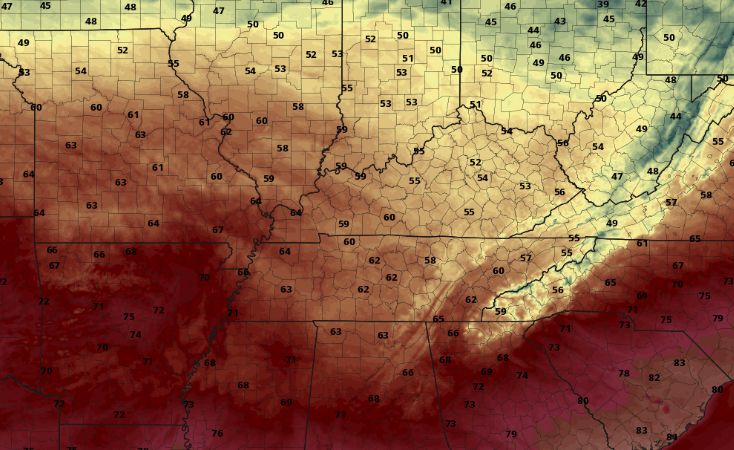 It is very important you have a way of receiving alerts (watches & warnings) overnight. As always, we'll be up late to keep you updated with the latest in regards to this system. Stay safe and stay weather aware! Radar shows a few isolated showers working through parts of Morristown, Greeneville, and Jonson City but these are quickly moving east as we get into the afternoon. Looking ahead, the day 2 SPC outlook (Wednesday am to Thursday am) a slight risk remains in effect for much of TN and KY. We are looking at the timing for this line to work through overnight Wednesday and early into Thursday. The primary threats will be damaging winds and hail but isolated tornadoes can't be ruled out either. 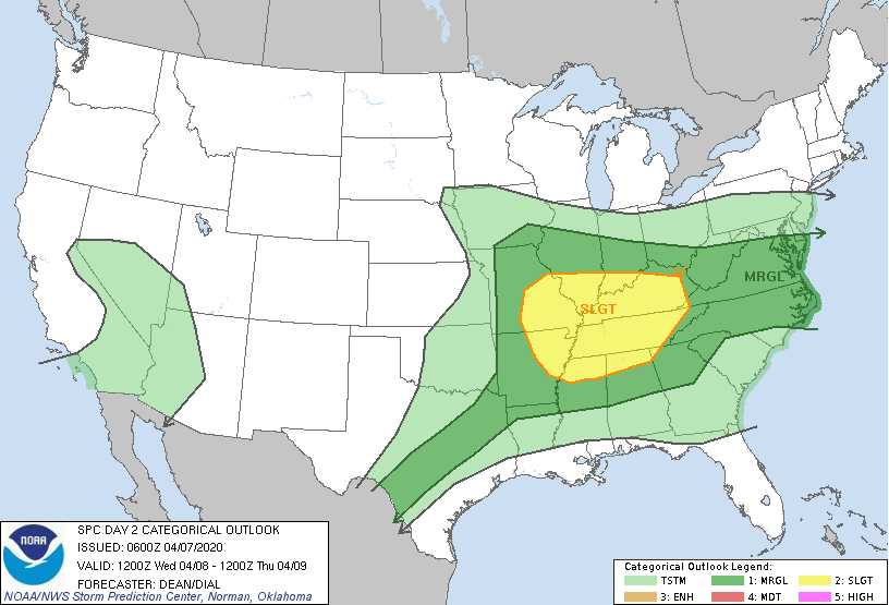 The latest surface map helps depict the setup of this unsettling weather. A low pressure system to the north will work its way east as a trailing cold front develops. Ahead of this cold front is where we will see the best chance for strong shower/storms. Once the cold front works through (late Thursday morning), we'll begin to dry out, clear out, and cool back off. 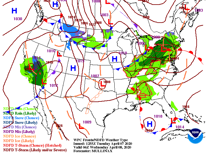 Similar to yesterday, a few isolated showers are possible throughout the afternoon today. We will stay calm overnight with showers and storms redeveloping into Wednesday. As a cold front works in to the north, stronger showers & storms will develop to the west. As we progress through the later half of the day Wednesday and into early Thursday, expect this line to move through the area. Be weary! This (weakening*) line will work through while many of us are in bed so have a way to receive alerts and take the proper precautions if things do become severe.  Looking ahead into mid-April, much cooler air is expected to work in. This is important for those in the agricultural sector as frost and freezing temperatures are something we'll be keeping a close eye on. If you want more details into the timing, how long this will last, and when the most ideal time to plant will be, shoot us an email at SecretCityWx@aol.com or check out our services tab at the top of our website.  That does it for today...enjoy another warm and mild afternoon and check in for updates tomorrow as severe potential is something on our radar. |