|
Cloud cover has made a return this afternoon as a weak system to our south pushes eastward. This will lead to isolated/ scattered showers for Saturday. Highs will also be a bit cooler tomorrow with the added cloud cover and spotty rain, in the lower 60's. Luckily, temperatures tick-up a bit Sunday and Monday of next week. 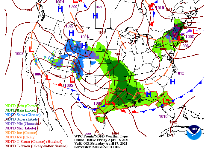 Breaking down the rain potential tomorrow, showers will work in from the west. As they do so, moisture will be light with rain amounts around a tenth of an inch for most. Overall, rain will be light and quick moving, leading to clearing overnight Saturday. Sunshine is set to return for Sunday but an isolated afternoon shower can't be ruled out. The same trend continues into the new work week with sunny to partly cloudy skies and an isolated shower each day.  Something we'll throw out now of concern is the chance for frost and/or freezing temperatures. A cold pivot will take place across the central and eastern US, leading to the chance for damaging plants/crops. The latest model guidance (one of many) indicates temperatures (lows) in the low to mid 30's mid-week next week. Of course this is early, but we wanted to give you the lead time to take the proper precautions. Trends have pointed toward a cold swing Wednesday/Thursday of next week for the past couple of days, so be aware moving forward. We will keep you updated as always! 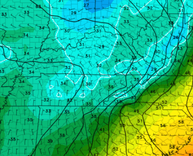 For the most part, this weekend will be on the drier side. Even with showers in the forecast tomorrow, they will be light (tenth of an inch) and move out by Saturday evening. Sunshine and warmer temps will be in for Sunday with improving conditions Monday. Have a good weekend and don't forget to share your pictures by sending them to SecretCityWx@aol.com or tagging us on Twitter/Facebook. Pre-recorded for 5pm show
0 Comments
Good morning! The latest satellite loop has clouds over much of the state but clearing will gradually take place through the day. Looking at satellite below, Western Tennessee is already beginning to clear out with daytime mixing likely to assist in decreasing cloud cover across our neck of the woods. Highs will be a bit cooler today with the passage of a cold front, in the mid 60s. 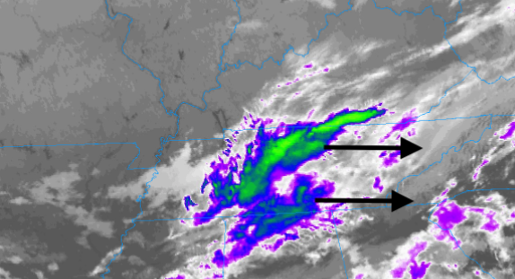 Progressing ahead, dry air doesn't stay around for too long. Another feature will provide the chance for showers Saturday and early Sunday morning. This next round continues to look unimpressive with light scattered showers and totals up to 0.15". The biggest impact will be the cool air to follow as highs will likely drop through much of Saturday. By Sunday, we rebound a bit with clearing skies through the day. Trends hint toward clearer and drier conditions much of next week.  Looking at Saturday, another cold front will work across the state. With highs likely to fall early in the day, we'll see temperatures struggling to reach 60 degrees. Cloud cover should continue to stick around Saturday night, helping buffer too cold of air. Frost could be a concern tonight for some of the deeper sheltered valleys, so use the proper precautions with lows in the mid to upper 30s. 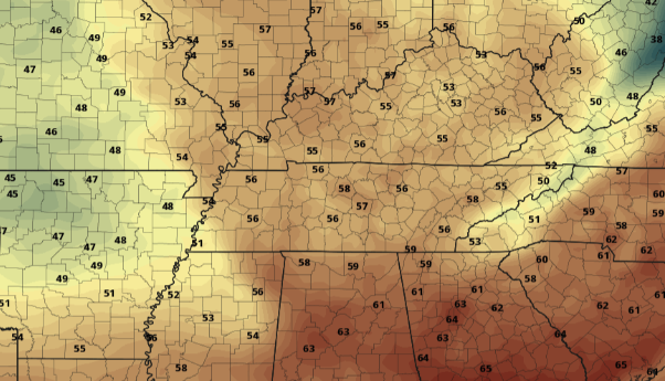 The pattern ahead is more or less a drier one with temperatures trending below average. The exception will be Saturday as a weak system (bringing light showers) and cold front push across the region. Temperatures rebound a bit next week, but remain on the cooler side. Pre-recorded for 5pm show
The latest drought map for the state is back to normal. This is a change from the abnormally dry spots we saw for numerous weeks across Western and Middle Tennessee. The heavy rainfall and flooding we saw a few weeks ago helped bring things back to average. As the pattern shifts, the second half of April is expected to be more dry and thus, could see drier spots return.  Breaking down what you'll see today, an elongated band of precipitation will arrive. This NE to SW orientation will allow for showers to hold off until the afternoon before bringing upwards of half an inch to East Tennessee. Following, clearing will quickly take place as the front shifts eastward. High pressure will then build in for Thursday and Friday before another system brings the potential for rain Saturday and Sunday. This next round looks unimpressive, with shower chances dwindling as the feature works east. For now, anticipate the chance for some showers this weekend, but they look pretty minimal.  Generating an ensemble graphic, the average between the ensemble members is right around 0.3 inches of rainfall today. Some locations could see upwards of 0.5 to 0.6 as repeated showers work across the area, but this won't be a "washout" type of event. Rain into the weekend will likely be much less with some areas only picking up a few one-hundredths.  Outside of the rain we see this afternoon, the biggest change will be the temperatures. Our average high this time of the year is the low 70's and highs will range from the upper 50's to low 60's tomorrow afternoon. We rebound a bit Friday as high pressure arrives, but still remain below average. Pre-recorded for 5pm show
As our next system rounds in, moisture will pull in from the Gulf. There is a limited opportunity for showers bordering Kentucky this afternoon, while the remainder of us stay dry with increasing clouds. As we work overnight and into Wednesday, better rain chances arrive as the low works further east.  Looking at model guidance, showers work north of the region tonight. By the overnight hours and into Wednesday, showers will begin pouring in from the west. Though this is a fairly weak system, we can still see upwards of half an inch of rain. Some locations where repeated showers work through could see upwards of an inch. Either way, this will be a fairly quick hitting system with minimal impacts. Lightning and thunder may be possible, but instability looks pretty weak and no severe weather is expected. Progressing forward, clearer skies arrive Thursday and Friday before another dose of rainfall is in for the weekend. 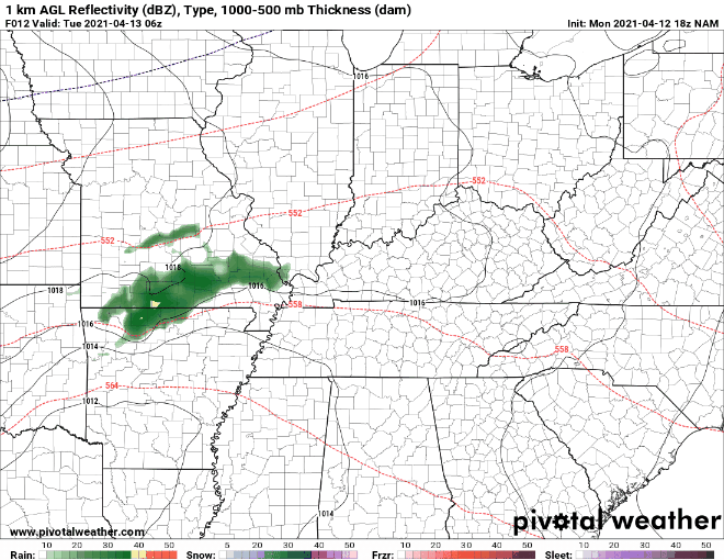 Longer term, the later half of April is trending dry. Not only for the eastern half of the US but as a nation. We will continue to keep a close eye on how this may impact drought conditions moving forward, but for now we have had plenty of rainfall across the state. 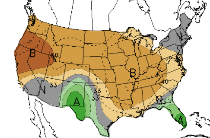 A round of showers is in for Wednesday as the low drifts a bit further north than previously forecast. Overall rainfall accumulations look pretty minimal, with "training" showers & few storms bringing higher-end totals near an inch. Pre-recorded for 5pm
The beginning of the new work week starts with lots of sunshine and above average temperatures. For the pattern, we sit idle between high pressure and low pressure to the north and west. A front will also stall out just to our south as a low develops across Texas and works east. This will allow for the chance to see a few isolated to scattered showers midweek, but rainfall amounts look very unimpressive.  Looking at model guidance, dry air remains locked into place through today and much of tomorrow. We could see a few isolated showers arriving by Tuesday night, but the best chances arrive for Wednesday. This model in particular tends to veer toward higher rain chances, so we have dialed back those percentages for Wednesday. Following scattered rain chances midweek, a cool down is in store.  Looking at the latest CPC outlook for the 7-10 day range, well below average temperatures look to be the trend. As high pressure and northern flow arrive the second half of the week, highs will range in the mid 60's with overnight lows in the upper 30's and low 40's. Frost will be the biggest hazard with this as some of our deep valleys and higher terrain will be the most susceptible. 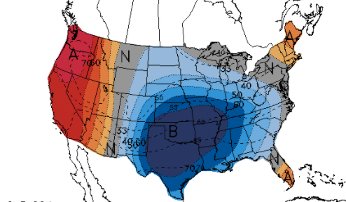 We begin the new week beautiful but a pattern shift will allow for much cooler air by Thursday and Friday. Find out additional details below. Have a good Monday! Pre-recorded for 5pm show
It has been a pleasant start so far today with mostly clear skies and temperatures in the lower 50's. Satellite and local reports suggest some patchy fog near water-bodies, otherwise things are clear and dry across the region. For those who missed it, we did have rounds of severe weather graze the northern Plateau and work into Kentucky yesterday afternoon. Many funnel clouds and signs of tornadoes can be viewed on our social media. The area's hit the hardest includes Scott, Claiborne, and northern Campbell counties. Continue to send us reports if any come in!  Working ahead, a low will work back in from the south and west. This next round will pose similar severe threats (isolated) but bring a better chance for rainfall. Looking at model guidance below, isolated to scattered showers arrive late overnight tonight and through a good portion of the day Saturday. The timing for heavier showers and storms comes in the morning to early afternoon. Gusty winds, heavy downpours, and small hail will be the primary threats, but we can't rule out the chance for a few isolated severe cells. By Sunday, we clear back out with warming temperatures into Monday. Mostly sunny skies look to be in the forecast for much of early next week.  In additional to the Marginal (to slight) severe risk tomorrow, we also have a portion of far southeastern Tennessee under a marginal risk for flash flooding. With showers expected to "train" along this area, rainfall will likely add up quickly leading to the chance of flash flooding. Use caution if you are along water bodies, low-lying areas, or flood prone locations. 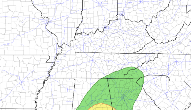 That will wrap it up for today...I hope everyone has a good weekend! As always, we'll provide updates via social media through Saturday and Sunday. Have a good one, stay dry, and enjoy the improving conditions Sunday and early next week. Pre-recorded for 5pm show
Good morning! Don't forget to throw in an umbrella as showers have arrived across parts of the Plateau and western edge of East Tennessee. Progressing through the day, SPC has placed East Tennessee under a Marginal Risk for severe weather. I still am pushing towards not-likely, but daytime heating could fire-up some afternoon convection strong enough to be border-line severe. Gusty winds and small hail will be the main threats with moderate to heavy showers/storms possible at times. 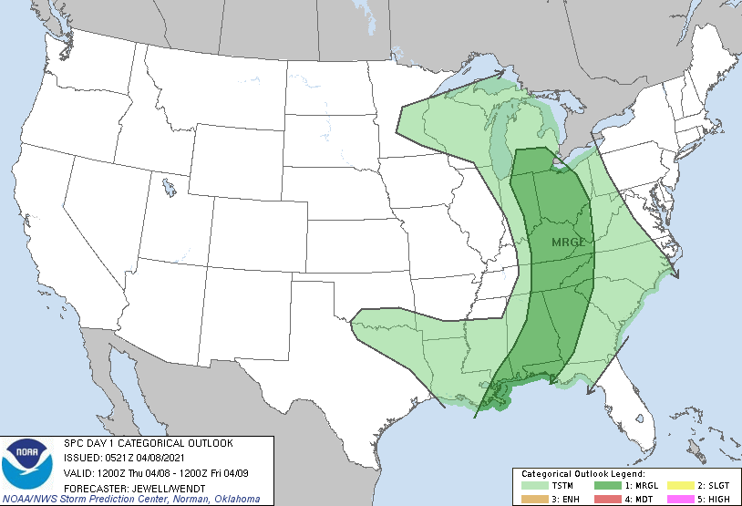 The play-by-play for the day has showers this morning followed by a line of showers and storms this afternoon and early evening. Again some of these could be stronger at times but I am not anticipating much in the severe category (but don't entirely rule this out). We'll keep you posted on any severe warnings that could be issued as this line works eastward through today. As we push into Friday, we dry back out a bit before another round of showers and isolated showers return Saturday. This will again be a quick hitter with sunshine and warming temps Sunday and early next week.  That does it for today! Showers are likely on and off with a few isolated storms possible early this afternoon. Better conditions arrive to end the work week tomorrow with highs near 80 degrees. Pre-recorded for 5pm show
Happy Hump Day to you! Hope you have packed an extra bottle of water because today is gonna be a warm one. We could potentially see some record-setting heat across East Tennessee this afternoon. Records are as follows below: The best potential will be Oak Ridge as highs are expected to top out right around that 83 degree mark (records don't date back as far there). The remainder of the larger cities will cut it close. High pressure is to our east allowing for plenty of southerly flow....the biggest setback (record beating wise) will be how quick and how much cloud cover is across the region through the afternoon. Time will tell, but do keep in mind the well above average temperatures. 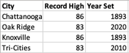 Looking at model guidance, nearly all are trending a bit more conservative with highs. Most have the valley topping out around 80 degrees but I am shooting for a few degrees warmer. With the positioning of the high, warm southerly flow, and past trend, I expect most to be in the low to mid 80's. 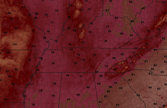 Moving in to tonight and tomorrow, rain makes a return. A system currently working through the Central Plains will shift eastward bringing widespread rainfall late overnight (for Western/Middle TN) and into East Tennessee for Thursday. Rain amounts do not look too impressive with guidance suggesting around half in inch. Some locations could see locally heavier rainfall in areas where storms are moving through. We are not anticipating any severe threat through the day but areas of gusty winds and heavier rain are possible.  We will see another wave of abnormally warm air today before a little "cool" down arrives tomorrow with temperatures knocked down to the low to mid 70's. A few rounds of rain will also dampen things Thursday and again for parts of Saturday (more details below). Pre-recorded for 5pm show
Warm air dominates much of the eastern half of the USA as high pressure continues to hang across the region. That trend again continues through today and Wednesday with highs both days in the low to mid 80's. In fact, Chattanooga could see highs nearing the mid to upper 80's by tomorrow afternoon.  Looking below, high pressure will continue to shift east today allowing for southerly flow overnight tonight and into Wednesday. This will increase temperatures as well as dew points, setting up shop for rain tomorrow night and into Thursday. A chance for moderate to heavy storms (including lightning, gusty winds, and small hail) will be possible Thursday afternoon. 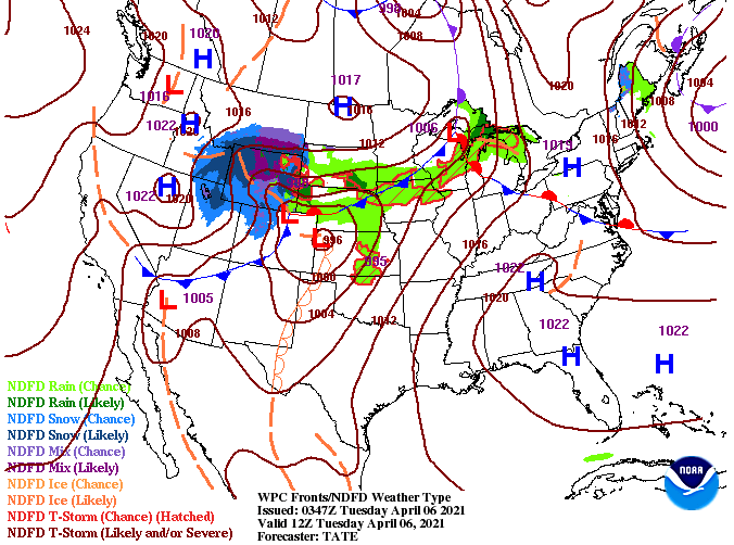 We aren't expecting any severe weather as the better parameters (though marginal) will hang west of East Tennessee. This should be a pretty quick moving system bringing a range of 0.5" and 1 inch Wednesday night through Thursday night. A few isolated to scattered showers hang around for Friday before better opportunities into Saturday. 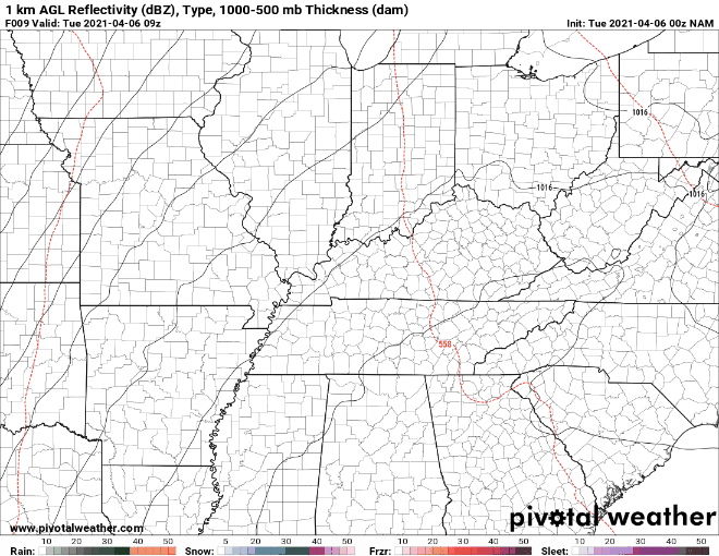 The biggest news will be the heat today and tomorrow. Temperatures well above the average are in the forecast so be sure to practice heat safety. Even with temperatures in the 80's heat related illnesses can strike if you aren't careful. Pre-recorded for 5pm show
I hope all had a wonderful weekend! Taking a look outside, everything seems peaceful so far today with sunny skies, light traffic, and temperatures in the low 40's. As we swing into the new work week, we continue to stay on the warm side. Highs this afternoon are expected to top out in the mid to upper 70's, and some locations around 80.  Longer term (7-10 days) the Climate Prediction Center suggests temperatures to maintain their trend: at to above average. Even precipitation will stay on course with at to below average expected. This will be something to watch for in the weeks ahead and how this could play a part in drought conditions for parts of Spring.  Aside from the mild temperatures and sunny skies, we do have changes coming later in the week. A round of showers is expected late Wednesday and through Thursday. Generally, amounts will be around half an inch. The bulk of heavy rainfall will stay to the south and west (middle and western TN). Following this round of rain, conditions look to clear and dry back out.  For now, enjoy another warm and sunny day. We continue this trend into Tuesday as well before cloud cover and shower chances return late Wednesday and into the day Thursday. Pre-recorded for 5pm show
|