|
A few isolated showers are working through the valley this morning and will be more widespread throughout the day and into the evening. With the wet soils we've had the past few days, NWS Morristown has issued a flash flood watch (highlighted GREEN) for the northeastern corner of the state through today. It is important to note all of East Tennessee is under a Marginal Risk of Flash Flooding through the day today. Stay abreast to the latest alerts if they are warranted, particularly near water bodies and low lying areas. 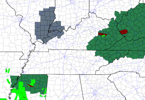 Showers and storms will be present through much of the day today and could lead to localized flooding given the slow movement of these cells. Pushing into the weekend, the low that brought all the moisture we have seen will begin working east. Large ridging across the Midwest will begin to push in, bringing drier weather and warmer temperatures late into the weekend and into early next week.  With clearing skies by late Saturday and through Sunday, UV indices will be high. Purples symbolize values between 10 and 11 on a scale where the max value is 15. The EPA continues to suggest high UV values through early next week as well, so don't forget the sunscreen. 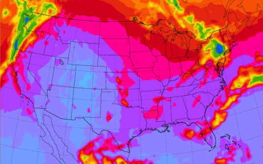 Overall, weather conditions will begin to improve once we get through today. Temperatures will be the next weather consideration as highs will be in the upper 80s and low 90s through the weekend. Make sure to stay hydrated and take breaks if you have plans to work outdoors. Don't forget to check out our daily video forecast below for more information as well. Pre-recorded for 5pm show
0 Comments
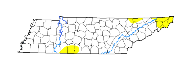
We'll start off by highlighting improvements across East Tennessee as it relates to the abnormally dry conditions that have been present the past couple of weeks. Most of these locations have now been confined to the Plateau and into the far northeast corner. I anticipate with the added rainfall this week/weekend we'll continue to see slight improvement this time next week as well. 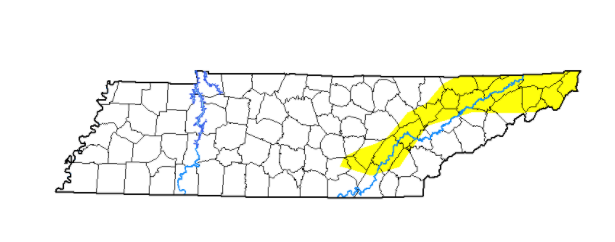 Some good news as it relates to the flooding threat. The WPC has dialed back their flash flood threat to a Marginal risk (5-10%). There was a slight in place from this time yesterday but with areas not hit as hard yesterday, this has been reduced some. Nonetheless, flash flooding remains a possible, especially if heavy showers materialize and work through similar locations. This could lead to "training" and the likelihood for flood and flash flooding conditions. This Marginal is in effect for both today and tomorrow (as of now). 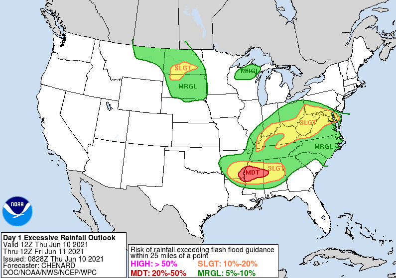 A play-by-play shows showers and storms developing this afternoon before again dissipating overnight. Better and more widespread showers are in store for Friday as a trough dips to our east. Activity will carry into Saturday as well before much needed sunshine begins edging back in Sunday and early next week.  That will do it for today. Have a way to receive alerts, especially if you are in flood prone areas. Heavy showers and storms will be possible through Friday evening before conditions gradually improve towards the end of the weekend. Pre-recorded for 5pm show
Cloud cover has worked in a bit thicker this morning as an upper level low works eastward. This will bring better shower and thunderstorm chances late today and especially into Thursday. It is important to highlight that the WPC has placed East Tennessee (today and tomorrow) under a slight (10-20%) of flash flooding risk. Those in low-lying areas, flood prone locations, and near water bodies should use caution and stay tune to watches and warnings issued by the NWS. 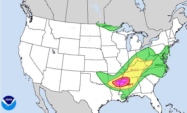 The image below depicts precipitable water. This means the amount of water in the atmosphere for a vertical column of air if it were to all fall as rain. In this case, most locations are in the 1.75 to 2 inch mark (WELL above average). Some spots, as highlighted in yellow, are near 2.5 inches. This could lead to flash flooding & rising water quickly if storms track over similar locations through the day. Again use caution and stay abreast to the latest alerts from the NWS. 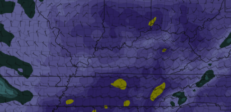 As we work through the next couple of days, the pattern remains much of the same. Afternoon heating combined with a very moist atmosphere will allow for showers & thunderstorms to develop during the late morning and through the evening hours. Things begin dissipating overnight before reforming again the next day. Luckily, there is light at the end of the tunnel. Drier conditions look to find us Sunday and into early next week. Though the severe threat is low, flash flooding is a medium concern. Storms that "train" or follow similar paths can quickly create rising water and flash flooding. Most shower and storm activity will be slow moving, only adding to the concern. Pre-recorded for 5pm show
Cloud cover lingers this morning but for the most part, East Tennessee starts out rain free. As we work through the day, showers and a few thunderstorms will develop with afternoon heating and shortwave energy working across the area. Temperatures will be a bit warmer today given the rising heights, with highs topping out in the mid 80s for most valley locations. 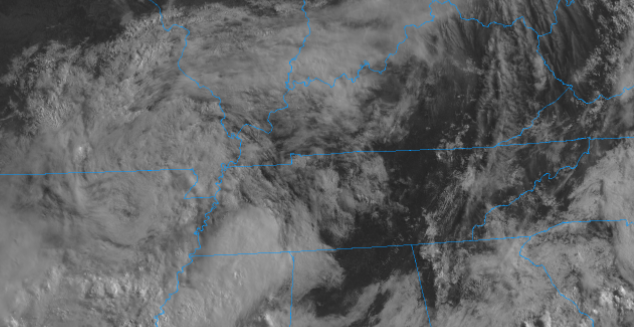 The pattern remains the same as Monday with conditions to follow to be similar too. Energy aloft combined with amble moisture and heat will provide opportunities for afternoon showers and thunderstorms to develop each day. Some areas could see localized heavy rainfall and gusty winds, otherwise showers should be relatively quick moving. It is worthy to note the WPC has a slight risk for flash flooding on Thursday as a low works eastward bringing moderate to heavy rains on top of already saturated soils. This will be something we'll closely watch over the next day or so.  For now, keep the rain gear handy. Things will continue to be warm and muggy today with showers and thunderstorms again possible. Flash flooding could become an issue by Thursday, so use caution in low-lying, near water bodies, and in flood prone areas. Pre-recorded for 5pm show
A few isolated showers have made it through the night, otherwise skies are mostly cloudy this morning. As we work ahead, precipitation is high this week. An active weather pattern will dominate much of the eastern half of the US this week with medium to high rain chances every day.  Looking below, lots of water vapor is being forced in from the Gulf of Mexico. Reason being, an area of high pressure sits off in the Atlantic and the clockwise flow of this system is advecting moisture in. Pulses of energy along with daytime heating will help in producing these showers for the next several days. 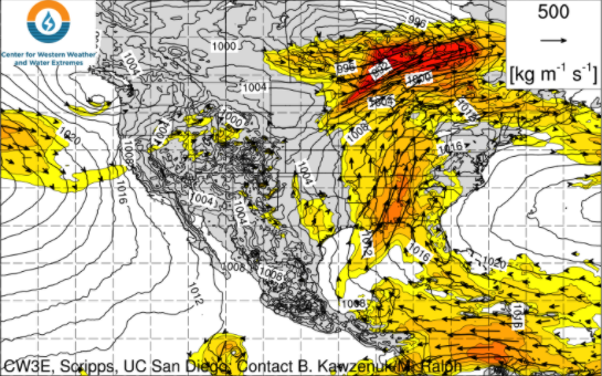 Scattered showers will start us off before a few storms become possible during the afternoon and early evening. This will mainly be the trend through the late work week before we buy a much needed break towards the late weekend. Anticipate the daily pattern of scattered showers, chances of afternoon thunderstorms, then activity petering out overnight. Rainfall amounts now through the weekend are expected to be between 2 and 3 inches.  Keep the rain gear handy this week. Showers won't be an all day event but more scattered and in rounds throughout the day before dissipating after the onset of nightfall. Temperatures will also be fairly consistent this week with highs ranging in the lower 80s and overnight lows in the upper 60s. Pre-recorded for 5pm show
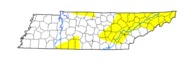
A dense fog advisory has just expired (9am) as many river valleys saw widespread fog. Pushing into this afternoon, cloud cover will continue to clear out leaving highs in the low to mid 80s. The latest drought map has worsened since last week. As seen below, (left to right) abnormally dry spots have increased, particularly across East Tennessee. Given the below average rainfall we have had this month, it is not surprising. On the flip side, most locations picked up 0.5"+ yesterday and another system is expected to arrive early to mid week next week.
With high pressure building in this afternoon, temperatures will be quite toasty for the start of the weekend. Most valley locations will top out in the upper 80s with lower 90s not out of the question for southern locations. 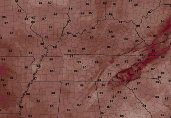 Showers will hold off until Sunday where an isolated afternoon pop-up shower/storm is possible in the higher elevations. The same can be said for Monday as well before a system arrives into Tuesday and Wednesday bringing widespread showers and a few storms. 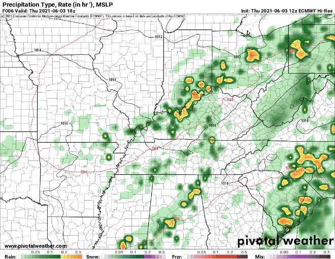 In the coming months, we will be looking to revamp our website. We hope to make it more user-friendly, informative, useful, and appealing. If you have some time (3-5 minutes), please fill out this brief questionnaire. Your answers will be beneficial in steering the direction we go! Link attached below or by clicking the "Website Questionnaire" https://forms.gle/mB2Pm1TitP1UFT539 Pre-recorded for 5pm show
Scattered showers and storms continue to work through early this afternoon as seen from the latest radar scan (12:35pm). Pushing through the afternoon, scattered showers and storms will continue to work in from the west bringing strong storms at times. East Tennessee remains under a Marginal Risk for severe storms today with the biggest threat being small hail, strong winds, and localized heavy rainfall. The best potential will be through the afternoon and early evening. 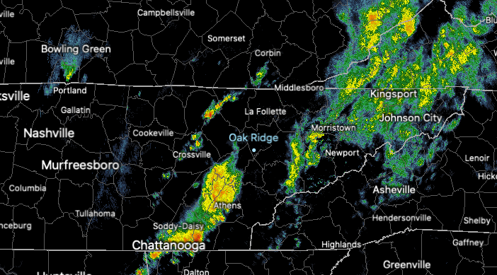 Model guidance depicts scattered storms working in this afternoon. As they do so, a cold front is trailing to the west and will bring bettering conditions for Friday. A few lingering showers are possible in the morning tomorrow (mainly for the Smokies), otherwise cloud cover will be decreasing and drier air will fill in. Saturday will be the best day of the weekend with partly to mostly sunny skies and highs in the mid to upper 80s. Afternoon showers/storms return Sunday and early next week.  Heavy showers and storms remain possible this afternoon, so remain weather aware. An isolated storm cell could become severe, so have a way to receive alerts (Twitter/Facebook @SecretCityWx). Pre-recorded for 5pm show
Cloud cover has dominated much of the morning and temperatures are reflective of that, nearly 10 degrees cooler in some spots than this time yesterday. Radar is also picking up on showers working across the northern plateau and upper valley (12:10pm). These will continue to work through periodically today before better showers/storms arrive tomorrow.  Looking at the latest SPC Day 2 release, all of East Tennessee is under a Marginal risk for severe storms (1/5). The parameters for this look weak, but an isolated strong-to-severe storm can't be entirely ruled out. The main threats will be gusty winds, small hail, and localized heavy rainfall at times tomorrow afternoon. For the majority of us, anticipate widespread rainfall, a few thunderstorms, then cloud cover slowly decreasing by Friday afternoon. 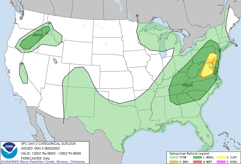 A look at modeled radar depicts the "run-down" for tomorrow. Showers will arrive early with a few thunderstorms trickling in by the afternoon and through the early evening. By Friday, a few lingering showers will fall into the morning before gradual clearing takes place in the evening and overnight. For the weekend, partly sunny skies will be the trend with isolated afternoon showers/storms possible.  Though the severe threat looks low and not very favorable, do be weather aware. We'll pass on any watches/warnings through social media, so if you don't follow us already check out our Twitter/Facebook @SecretCityWx Pre-recorded for 5pm show
Good afternoon! Conditions have been pleasant through the first half of the day, but satellite shows cloud cover continuing to work in from the west. This is apart of a low pressure system along Eastern Texas that will continue working north and east in the days ahead. For the remainder of the day, cloud cover will continue increasing with mostly cloudy skies expected overnight.  With high pressure located off the coast of the Carolinas, return flow will keep much of the eastern half of the US on the wet & active side. Moisture from the Gulf will continue to pump in through the second half of the week leading to rainfall totals as high as 4 inches across Western Tennessee over the next 5 days. Here at home, things look a bit better with rainfall totals around an inch. Again though, we are running on the dry side so any extra rainfall won't hurt. 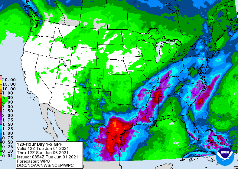 Showers will work in by tomorrow afternoon, so be sure to have the umbrellas handy. We'll see better rain and storm coverage Thursday and parts of Friday before a bit of sunshine edges back in for the weekend. For more details, check out our daily video forecast below: Pre-recorded for 5pm show
|