|
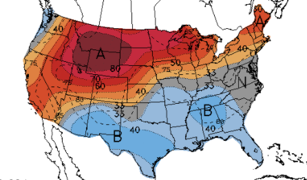
With rising heights across the Southeast, sunnier skies and drier air will be around. This will lead to both warmer temperatures as well as a higher risk for sunburns. As you can see below, the UV index will be high today (10-11). Be sure to both stay cool and hydrated but also keep that sunscreen handy. 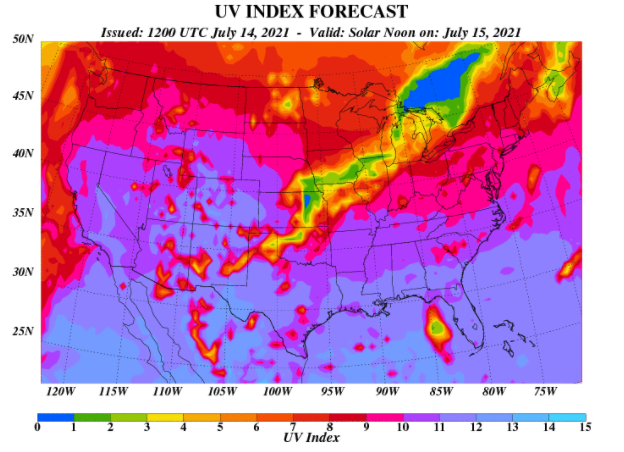 The good news is around only temporarily as rain chances quickly return for the weekend. A cold front and associated low will bring moderate to heavy rain/thunderstorms Saturday and especially Sunday. The latest from the WPC suggests rainfall amounts between 1.25 and 2 inches today through Tuesday morning. Heavy showers/storms that work over similar locations could see minor flooding impacts. Continue to stay abreast to the forecast in the days ahead. 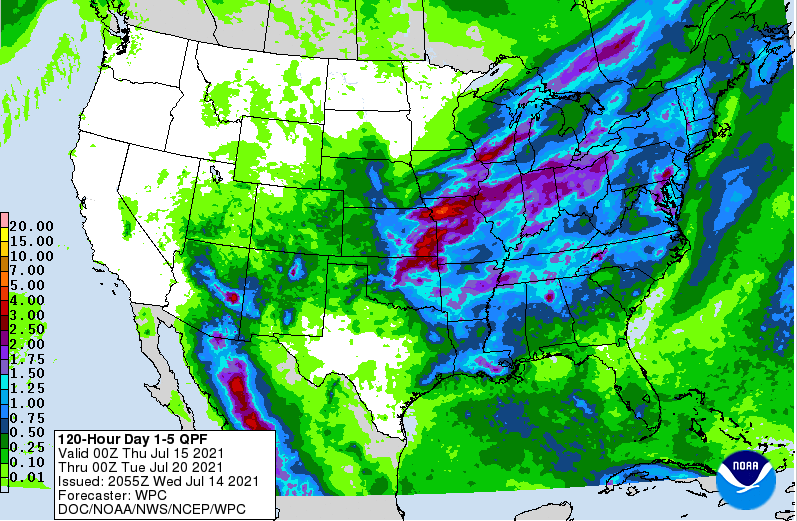 An isolated shower or two will be possible today, but most will stay on the dry side. Area-wide you can anticipate temperatures to be warmer (in the upper 80s) with around 90 expected for Friday. Continue to check back in for the latest as it relates to our next storm system this weekend. Moderate to heavy showers could bring a minor severe aspect as well as a minor flooding threat. Pre-recorded for 5pm show
0 Comments
Some better news for those wishing for drier days...the front has shifted through the region. This means high pressure will continue to edge in across the Southeast, bringing drier weather to East Tennessee. On the flip side, this will also increase temperatures through the end of the work week. Only isolated showers/storms are possible today and tomorrow, with most of these contained to the higher elevations.  Looking at modeled temperatures, most valley locations will top out in the lower 90s Thursday and Friday. Given the southwest return flow, humidity will also be an issue. This will make things feel even warmer than they are. Practice your heat safety if you plan to be outdoors for extended periods of time.  Take advantage of the briefly drier conditions expected. It may be a good one to enjoy by cooling off at the lake or pool. Showers/storms and a messy pattern again find us this weekend and into early next week. Pre-recorded for 5pm show
The pattern we are locked in has been very unforgiving. A set of slow moving fronts has led to rounds of afternoon showers and storms. That will again come today and Wednesday before we get a much needed dry day (for most) on Thursday. Again though, more activity will follow. Looking below, a cold front will be working down from Canada, bringing the chance for heavy showers/storms into the weekend. We are still a fair timeframe away but this will likely bring slightly cooler temperatures as well (low 80s). We will keep a close eye on things in the days ahead. 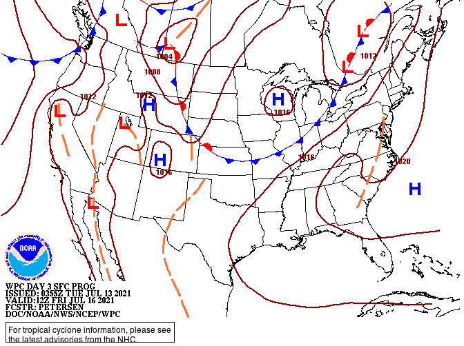 With high pressure edging in along the Southeast Thursday, temperatures will ramp up. Most will see highs in the upper 80s to lower 90s, but humidity will make it feel even warmer. We may lose most of the shower/storm threat, but the heat threat remains something to keep in mind. Drink plenty of fluids and stay cool! 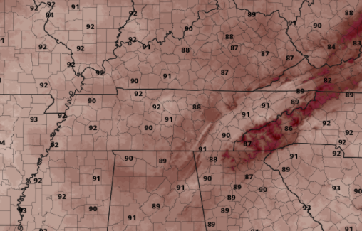 Afternoon showers and storms will again develop this afternoon and Wednesday with highs generally running near average (mid to upper 80s). Check back in for how our next storm system could play out into the weekend. Pre-recorded for 5pm show
Good morning! After a fairly soggy weekend, we will continue to see similar conditions early into this week. A VERY slow moving front lies just to the west and will eventually push through by Wednesday. This will bring a needed end to the daily showers & storms we have seen. Unfortunately, it won't last too long as more activity is on the way for this coming weekend. Looking ahead at the CPC's outlook from July 17 to the 21st, below average temperatures along with above average precipitation are expected. As for today, more rounds of afternoon showers/storms are possible with highs in the mid to upper 80s.
Taking a look here at model guidance, showers and storms will continue to develop during the afternoon and early evening. These will fade each night with the lack of heating and instability. Once the front moves through Wednesday, drier conditions are in store for Thursday before a cold front dives in from Canada bringing renewed activity and cooler air. 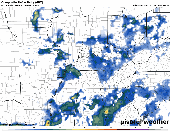 Don't forget your umbrellas...though there is little on radar now, activity is expected to fire up this afternoon. Not all will see rain/storms, but it is better to be safe than sorry. We will look to see bettering conditions, temporarily, once the front passes Wednesday. Pre-recorded for 5pm show
Radar shows a broken line of showers and storms working across Southern Tennessee and working southeast. Additional shower and storm activity is possible this afternoon as a front hangs just to the north. This will also lock in moist air for the days ahead, again leading to shower and storm potential. Heavy rains in the south could lead to localized flooding early this afternoon. 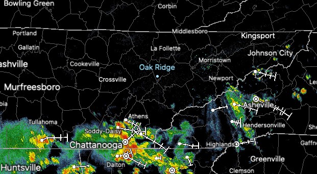 Contrary to last weeks drought map, we have actually picked up a few more abnormally dry spots. These are likely the cause of hit or miss showers combined with very warm temperatures. This is a normal pattern, especially August through September (where we are driest during the year). 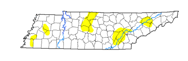 With a cold front just to the north, showers and storms will continue to be a nuisance in the days ahead. The front will lift north, settling across the Ohio Valley through the weekend and into early next week. Afternoon showers and storms will be possible through that time period.  As we have seen the past couple of days, showers and storms will pester us through the weekend and into the new work week next week. Drier but warmer conditions will be on tap for the mid to later part of next week. Have a good weekend and don't forget to check out or daily video forecast below. Pre-recorded for 5pm show
Elsa has moved quickly through the southeast and is currently in North Carolina. She will continue to work north and east, riding the eastern coastline through New England. Heavy rainfall and damaging winds continue to be the main threat with this system. 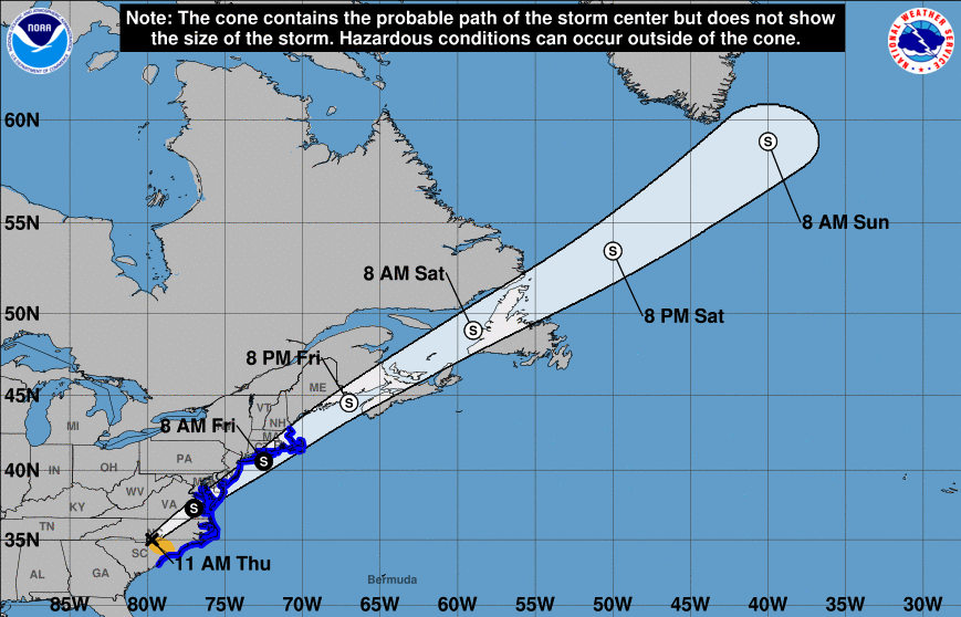 As for us here in East Tennessee, a cold front sits just to the north and west. This will pester us in the days ahead bringing daily chances for showers and storms. These will primarily be in the afternoon/evening hours, but a few can't be ruled out overnight and early into the morning hours. Some drier weather will begin to again find us towards the middle of next week.  Looking ahead, the CPC has released its mid-July predictions. They are expecting near-normal temperatures along with near to slight above average rain. For reference, our average high/low is 89/69 in Knoxville. 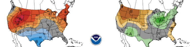 Broken cloud cover and scattered showers/storms will continue to pester us Friday and through the weekend. It will be hard to pinpoint exactly when you could see activity, but most will fall in the afternoon and early evening hours. Take advantage of those "dry slots" and have a way to receive updates when showers/storms do develop. Be sure to follow us on Twitter/Facebook if you don't already by following @SecretCityWx Pre-recorded for 5pm show
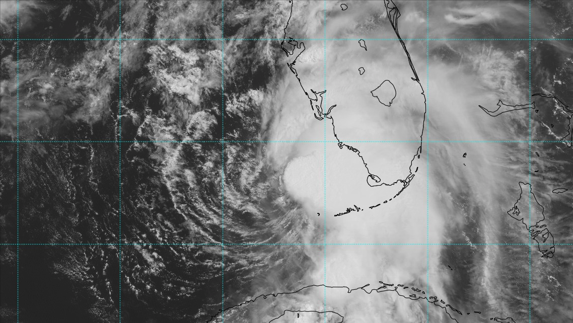
Heres the latest look at Elsa as she makes landfall in North Florida's Gulf Coast. Heavy rainfall and damaging winds are likely with this storm. In the days ahead, she will work northeast through Georgia, the Carolinas, and the New England coast. Other than a few showers/storms from Elsa's outer bands, don't expect much with this system across East Tennessee. 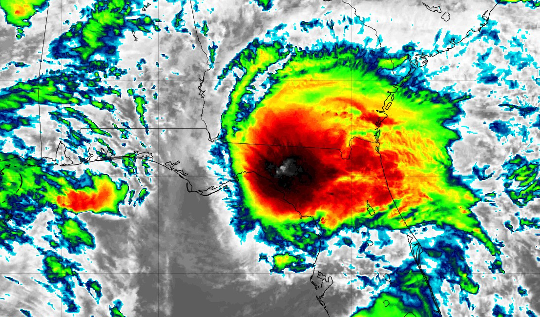 As for the drought conditions, or lack thereof, only a few abnormally dry spots hang around. Given the rains in the recent weeks, most locations are entirely back to normal. I anticipate given the rains this week, similar to better conditions can be expected ahead. 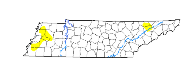 With a low to the north and Elsa to the south, we will be wedged between the two. Given the support of a jet and the two air masses, scattered showers and thunderstorms will be possible each day. These will be best for Thursday and Friday, but will continue at times into the weekend as well. With Elsa just to the south, cloud cover will look to linger through the end of the work week. 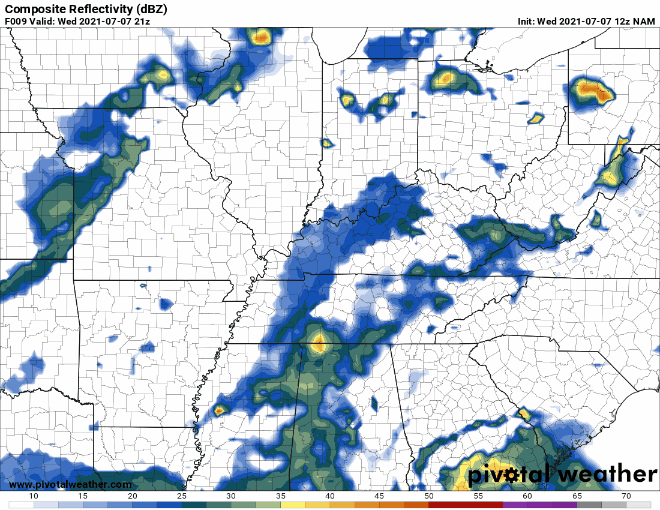 Elsa is expected to weaken to a Tropical Depression as it works through the Carolinas before picking up strength as it re-enters the Atlantic towards Friday. Temperatures here at home will be seasonable with highs mainly in the mid 80s over the next couple of days. Pre-recorded for 5pm show
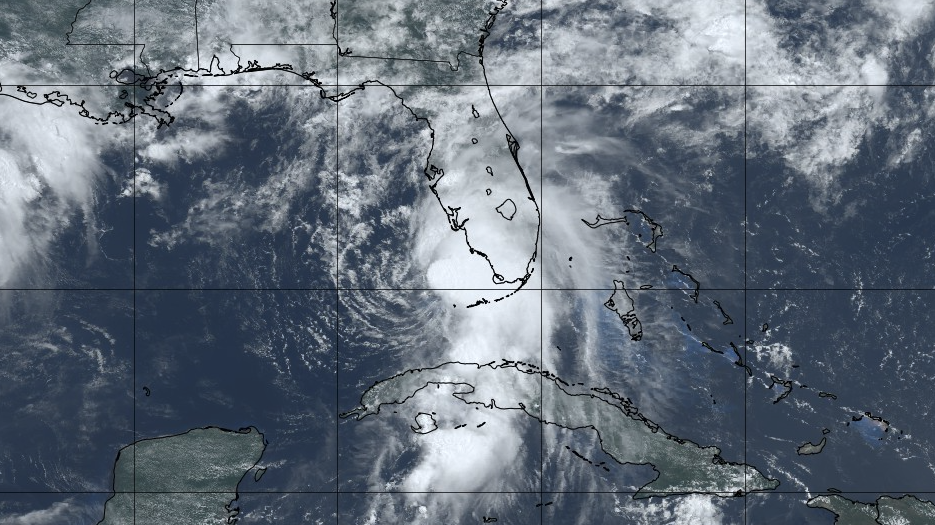
Elsa continues to churn through the Gulf this afternoon, riding dangerously close to Florida (as seen below). She is expected to make landfall late tonight/early into Wednesday morning as a Tropical Storm. Damaging winds and heavy rainfall (4-8+ inches) are expected. For more details view our video forecast at the bottom of this post.
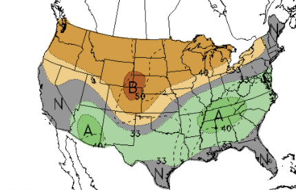
It is interesting to point out how much the UV indices are reduced with cloud cover. This doesn't mean you are not capable of getting a sunburn when it is cloudy, but dense cloud cover associated with a tropical system will lesson your odds for sure. Jumping back to home, East Tennessee will have very high indices today (10-11 for some). If you plan to be outdoors be sure to protect yourself from both the rays and the heat. Drinks lots of water, apply sunscreen or wear light colored clothing, and find a way to cool off. 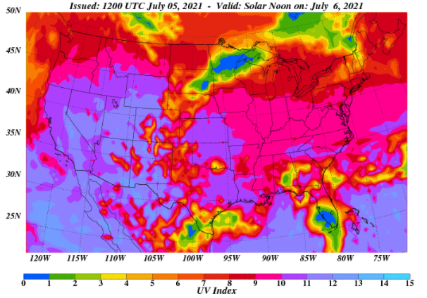 As we work ahead, this humidity will lead to isolated showers today but scattered showers/storms tomorrow. By Thursday, a low to our north will bring a chance for widespread activity that will carry into parts of Friday. We are not talking about a tremendous amount of rainfall, with generally upwards of an inch between now and Friday. Showers/storms will be hit and miss as well so think of this as a max average across the area.  Your typical summer-time weather pattern is underway. We have a tropical system to the south and isolated to scattered afternoon showers/storms possible each day ahead. A front brings better chances towards the end of the work week, but the heat and humidity stick around. Pre-recorded for 5pm show
Hope everyone enjoyed Independence Day yesterday. For those of you off today, it may be a good one to enjoy at the lake/pool....things are going to be HOT. Highs this afternoon will range from the low to mid 90s with feel like temperatures (seen below) in the mid (and for some) upper 90s. Stay cool, hydrate, and take breaks. 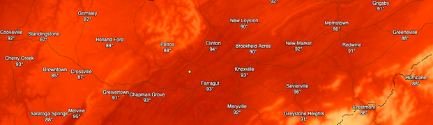 A big story (not expected to impact us) is Tropical Storm Elsa. This storm will work through Cuba this afternoon, then Florida by late Tuesday/Early Wednesday. She will work northeast dumping heavy rainfall across much of the Southeast. 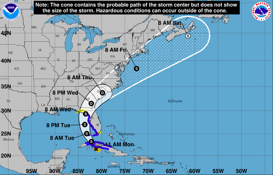 Here at home, the heat and humidity will lead to a few isolated/scattered afternoon showers & storms. These will likely first come tomorrow and Wednesday followed by better chances into Thursday as a low works eastward to our north. Elsa, seen later in the animation, will bring heavy rainfall to parts of GA and the Carolinas. 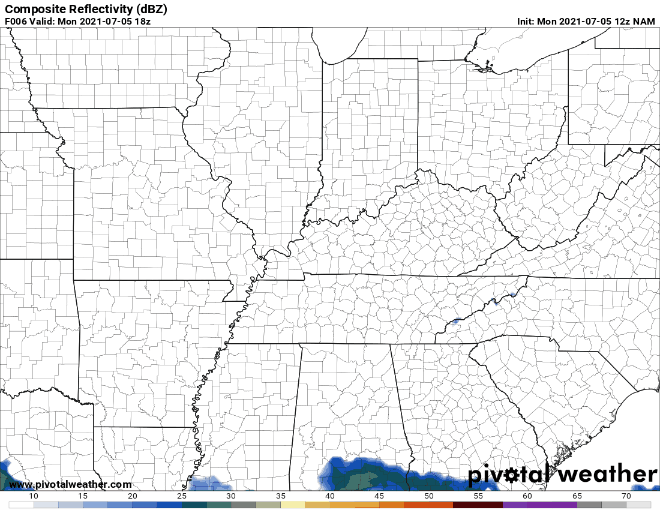 Stay cool and hydrated this afternoon and into Tuesday. Temperatures will be warm and muggy with feel like temperatures running into the mid 90s for most of the Central Valley. We'll begin to see afternoon showers and storms develop in the days ahead. Pre-recorded for 5pm show
|