|
Did you enjoy conditions yesterday? Sunny skies stick around today with temperatures a few degrees warmer. We'll also throw in an isolated shower or two this afternoon. While the majority of us will stay dry, we do need to look out for the UV rays. Again, it is in the high category with indices in the 8 and 9 range. 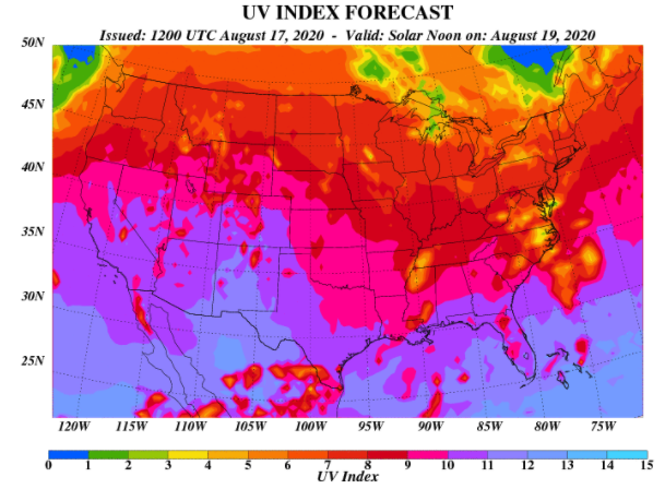 As seen from model guidance, things stay somewhat mild again today. Afternoon shower chances do begin popping up Wednesday and Thursday, but these will be scattered. Friday looks to be the best day for widespread activity, but still, not everyone looks to get wet. A high pressure system will develop to the north later this week as a wave of energy rolls through the south. Because of this, shower activity will be hit or miss. We upped the forecast "Weekly Forecast" but will look to likely tone it down a bit this afternoon.  The good news is a secondary front will keep temperatures cooler than average Wednesday and the second half of the week. The average high for mid-August falls in the upper 80's and guidance is suggesting temperatures 4 to 8 degrees below that across the eastern region. 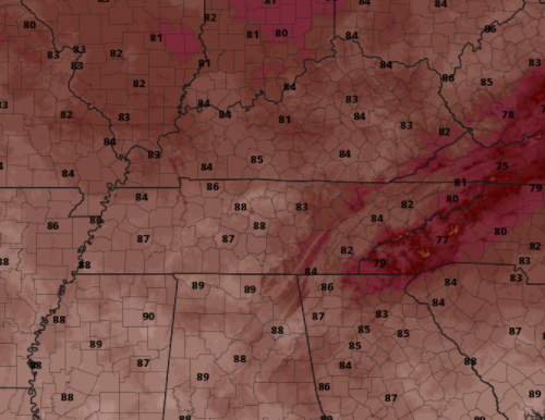 As always we'll keep you posted on the latest! Enjoy today before humidity values rise and the chance for rain returns.
0 Comments
Good morning and happy Monday! A weak cold front has moved through providing much needed relief from the heat and humidity. Expect to see sunny skies with high's in the mid to upper 80's. As we work through the week, shower activity will slowly creep back in. 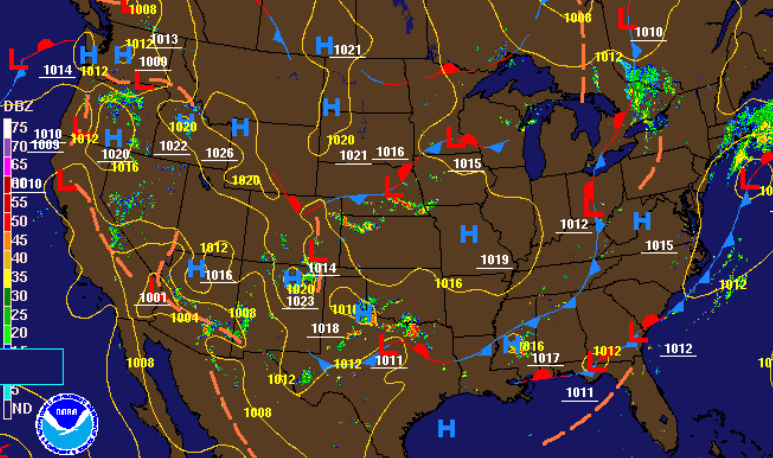 Things will stay relatively calm and peaceful the first half of the week. A stray shower or two may be possible Tuesday, otherwise conditions similar to today will be present. For Wednesday and the second half of the work week, afternoon pop up showers/storms will be possible.  A summer time cold front has allowed for much cooler, and important, drier air across the region. High's today will be in the mid to upper 80's and the trend ahead (as seen below) remains much of the same. Look to have high's in the mid 80's through Wednesday before humid air makes things feel a bit more sticky. 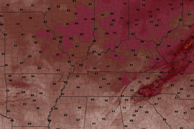 That wraps it up for today. Be sure to give us a follow on Twitter & Facebook (@SecretCityWx) if you haven't already. Updates come periodically throughout the day! Good afternoon! A look at the latest release for drought conditions across the state shows more negatives than positives. Southeastern TN has increased to moderate drought conditions while the remainder stay idle in abnormally dry. Cooler and drier air is anticipated longer term, so we'll likely see things intensify in the weeks ahead. 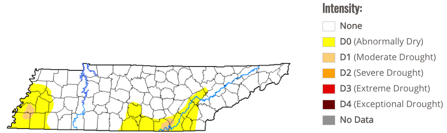 As for now, conditions this afternoon will be similar to yesterday. We were anticipating a bit more activity today but with the system moving very slow, most of the "action" will come Friday. As you can see below, a low is stationed in far western TN. As this works east, showers & a few storms will develop throughout the later half of Friday. 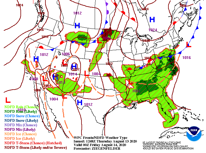 As depicted from the surface map, showers and storms will come from the east, developing by the afternoon and evening hours tomorrow. Activity will be scattered at times, but generally speaking, anticipate up to half an inch in your area. Amounts will vary in heavier cells. Additional scattered showers will work through Saturday before drier air arrives Sunday. In addition to some much needed rainfall, high's will drop into the mid 80's through the weekend.  A little gift from Mother Nature is in the long term forecast, so be sure to watch out daily forecast below for more details. Be sure to stay cool again this afternoon and keep the umbrellas handy tomorrow. Showers will likely begin firing off in the afternoon and continue into the overnight hours. Another hot and muggy one is in the forecast today. Lots of sunshine won't make things feel any better as UV indices are in the 9's and 10's (Very High). Be sure to apply the sunscreen and drink lots of water throughout today. 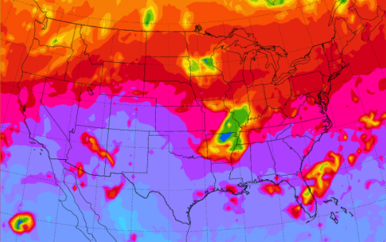 Conditions this afternoon will be similar to yesterday with the main story being the heat and humidity. A few afternoon showers are possible but the majority of us should stay dry. For Thursday and the days ahead, shower activity will become more widespread. As a front to the north and west draws near, increased shower and storm development will occur. The best chance for widespread activity falls Friday afternoon and overnight. 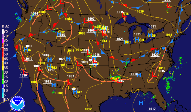 Things will stay somewhat dry today but that changes in the days ahead. Shower activity will stay scattered Thursday with afternoon showers and storms likely. By Friday, widespread shower & storm activity is expected the second half of the day and into parts of Saturday morning. The good news with the rainfall and cloud cover are the cooler temperatures. High's will be in the mid 80's tomorrow through the weekend so enjoy the brief reprieve.  The main threat today will be the heat and humidity, so drink plenty of fluids. If you'd like more information on how we can help you or your business, send us an email at SecretCityWx@aol.com or visit our "Services" tab above. Good afternoon! Prepare for a very warm and muggy day. Heat indices are expected to top out near 100 degrees (as seen below). A few isolated showers/storms will be possible again as well, but most of us will stay dry. 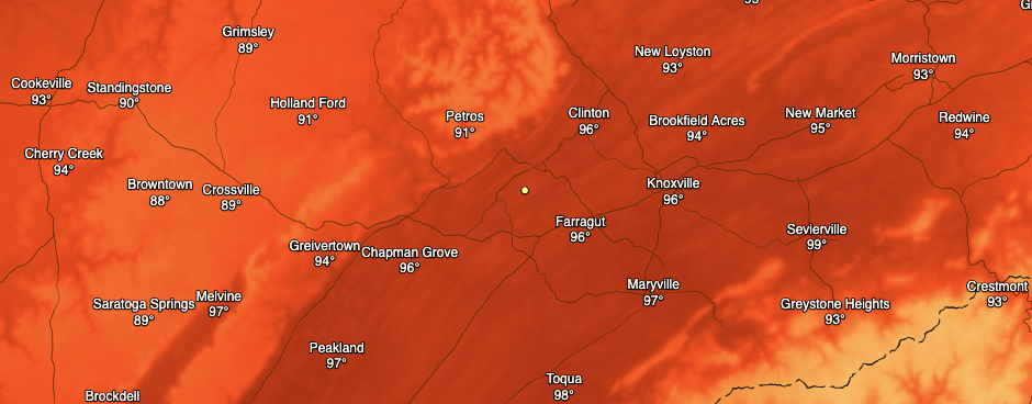 The best rain and storm chances arrive late work week (Thursday through the weekend). A front to the north and west is slowly making its way south, eventually providing increased instability across the region. The latest model trends continue showing scattered showers throughout the day (Thur-Sat), some of which could be heaver at times. Like we have seen so far this week, activity will again fall into the afternoon and evening hours before fizzling out late. Because showers later in the week are expected to be scattered, precipitation totals will vary between 0.75" and 1.5" (Thursday through Saturday).  Another tropical disturbance is quickly developing in the Atlantic. The Hurricane Center anticipates this to develop into a Tropical Depression within the next 48 hours, and possibly, by the end of today. We will keep a close eye on path and intensity in the days ahead as this is expected to work west-northwest at 15 mph. 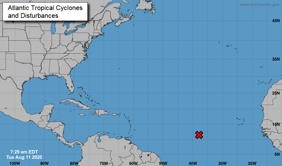 Thank you for joining us today! Don't forget to give us a follow on Facebook & Twitter if you haven't already and don't forget to share Secret City Weather with your friends, family, and co-workers. Moderate showers are currently working through the region providing heavy rains, gusty winds, and lighting. For the latest radar scan, check out the "Radar" tab above. A moderate risk for severe storms is in place for this morning. As we work further into the day, shower activity will lesson, leaving a cloudy and dry overnight. 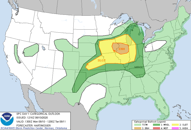 With a high pressure system to the east, winds will come from the south in the days ahead. This will funnel in warm and muggy temperatures across the south. Heat indices (as seen below) are expected to top out in the lower 100's for most. Heat safety will be key Tuesday and Wednesday, so stay well hydrated and cool. 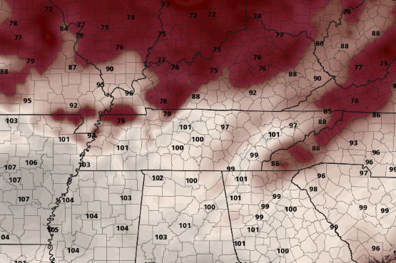 As showers move out the later half of today, temperatures will stay near average in the upper 80's. Some clearing will take place overnight leaving partly cloudy skies Tuesday and Wednesday. Afternoon showers and storms are possible tomorrow and Wednesday but will be scattered. The main threat, as emphasized above, will be the heat and humidity. By Thursday and Friday, a front to the north will move in increasing instability across east Tennessee. This will be the best opportunity for widespread shower and storm activity, so we'll keep a close eye for the end of the work week. 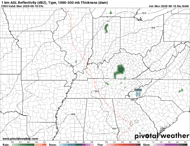 As showers work out this afternoon, cloud cover will keep things somewhat average. Tuesday will be very warm and sticky so take into account your heat safety. For more details, check out the latest video forecast below: A beautiful day is ahead as we close out the work week. High's are expected to top out right around the average (upper 80's) under partly cloudy skies. A stray shower for parts of the Smokies will be possible, otherwise the rest of us will stay dry and warm. 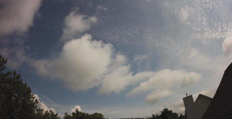 Image courtesy of the Stansfield's With a high in place to the north, shower activity looks to be out of the question for most of the weekend. The main threat will be temperatures, as they will return to the low to mid 90's. By Monday and Tuesday of next week, shower activity begins to creep back in with higher moisture values across the region.  An update from Colorado State University shows an active second half to hurricane season. Unfortunately, now through Mid-October is the most active time of the year for the Atlantic. The forecast has been upped from 19 named storms to now 24 (the highest forecast ever). In addition, 12 hurricanes and 5 major hurricanes (cat 3 or higher) are predicted in the weeks/months ahead. As you can see, nearly every prediction is double the average. It's easy to conclude the second half of hurricane season looks to be an active one after already starting the year with a record number of systems. 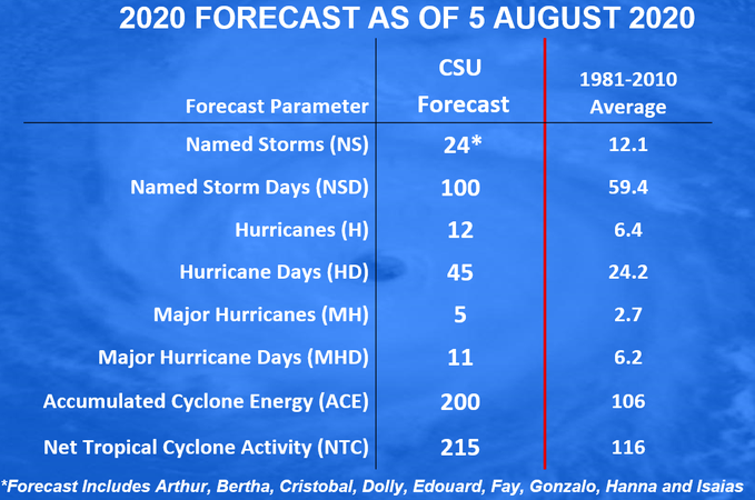 As we work into the weekend, keep your heat safety in mind. It will definitely be a good weekend to cool off at the lake or pool as high's will be in the 90's. Stay safe, stay cool and have a good weekend! A batch of heavy showers and storms has developed in the Plateau earlier this morning and continues to work east. You can see the latest scan under the "Radar" tab above. Looking ahead, drier air is in the forecast. As the system to the south moves out, a high will continue building into the region. Lots of sunshine is in store for Friday and the weekend so pool and lake plans will be a go. 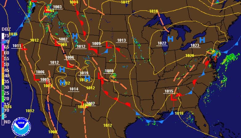 Shower and storm activity will remain possible through this afternoon before clearing up overnight tonight. Working in the days ahead, there is little to discuss. As some drier air funnels in, the main threat will be the heat. High's are expected to return to the low/mid 90's through the weekend with heat indices nearing the triple digits for some. Stray afternoon showers will be limited in the days ahead, so cooling off at the pool or lake may be a good idea.  The latest update on drought conditions in TN remains the same as last week. Abnormally dry conditions still dominate much of east TN and far west TN. With limited rainfall expected the next couple of days, we'll look to see if this gets worse. Especially as we enter the driest months of the year, a close eye will be kept on the conditions. 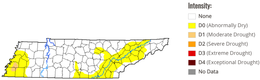 That will do it for today. Be weary of heavy showers and storms this afternoon. Localized flooding is possible along with gusty winds and frequent lightning. Drier days are ahead but so are warmer ones. We've had lots of sunshine to begin the day and the latest UV index forecast shows that. Values in the 8 and 9 range mean keep the sunscreen handy. We will continue seeing the sunshine to end the work week and through the weekend. 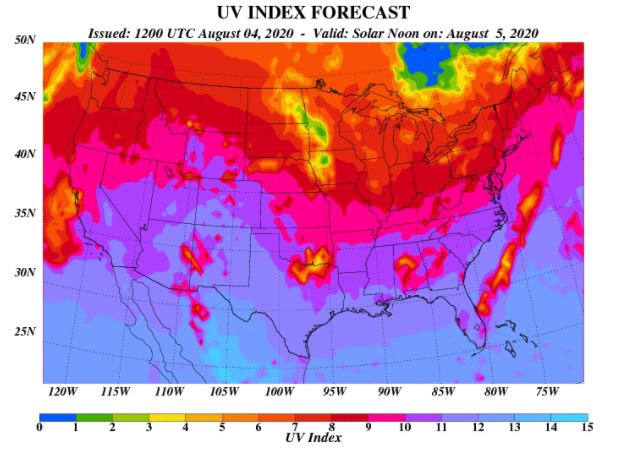 A high pressure system covering much of the eastern US is the reasoning behind the sunnier conditions. We will also see temperatures build each day with high's returning to the low/mid 90's by the weekends end. 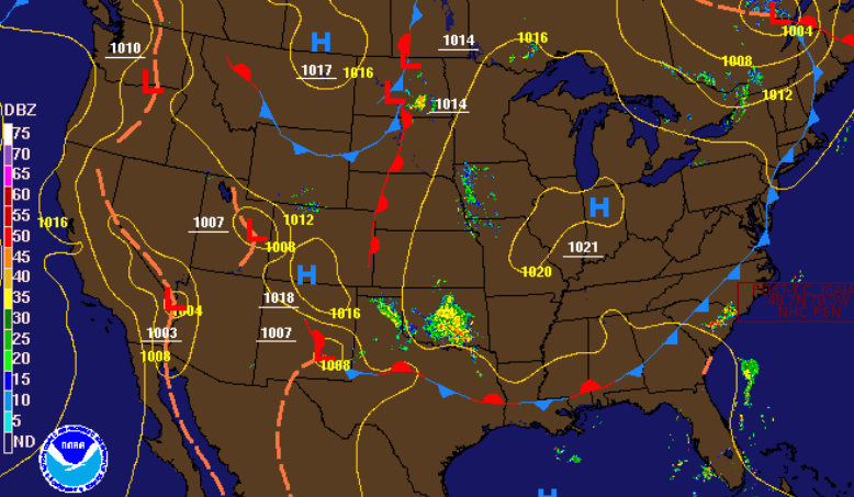 Though the main threat will once again be the hot temperatures, afternoon pop up showers and storms remain possible. As is the usual trend this time of the year, the majority of activity will be in the higher elevations. Longer lasting cells will move through the central valley at times during the afternoon, otherwise the remainder of us will stay dry in the days ahead. Keep your umbrellas handy just in case. 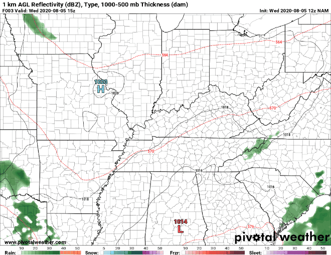 That will wrap it up for today! If Secret City Weather can help you, let us know by visiting the "Services" tab above. Spotty showers and storms have developed in parts of the Plateau and northern valley. The remainder of us will stay dry today under partly cloudy skies and high's in the low to mid 80's. That's 5 to 8 degrees below the average for this time of the year so enjoy these temps while they last. 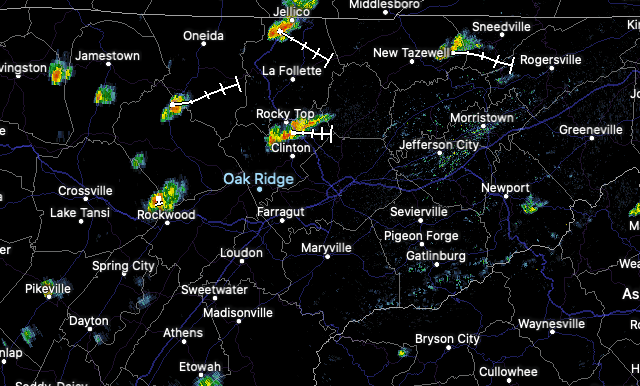 I will emphasize "enjoy the temps while they last" because a high pressure system is building in. This will funnel in warm and muggy southern air in the days ahead leaving high's back in the 90's by Friday and the weekend. The good news, for now, is the cold front that has over through. More opportunity for sunshine (as we have seen so far) and the cooler temperatures make things feel rather pleasant today. Similar conditions will be present through the remainder of the work week just with increasing temperatures each day. 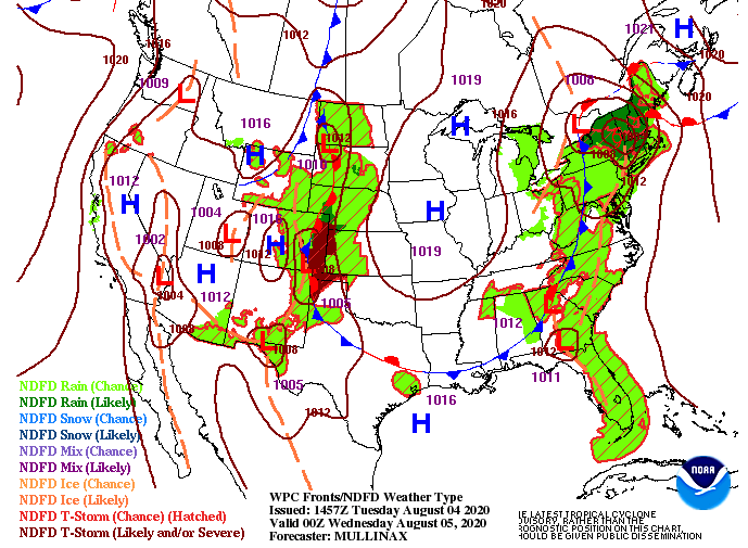 Changes are ahead as a warming trend finds us mid-August. As we will come to see later this week, this brief period of below average temperatures won't last long. The latest CPC forecast shows warm temperatures to return for much of the eastern half of the US. The CPC also suggests above average precipitation through mid-August. This is good news as August and September are our driest months of the year. With abnormally dry conditions present around the state any additional rainfall will be welcomed in the weeks ahead. 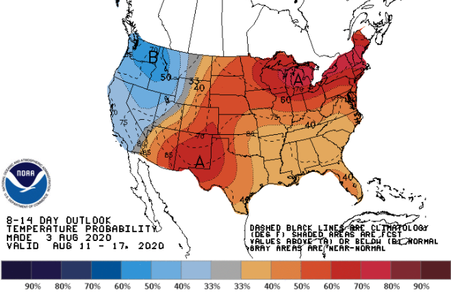 Enjoy the temps today before hot and muggy conditions return by weeks end. A few afternoon pop up showers and storms will continue today as well so look out for those on your way home from work and school. |