|
The outer bands of what's left of Fred are already seen across East Tennessee this morning. Because of the rainfall we have picked up the past several days and the heavy tropical moisture expected today, a Flash Flood Watch is in effect through tomorrow morning. This means heavy rain is expected for the highlighted counties with upwards of 4+ inches possible. Flash flooding is expected to occur, so be weary of warnings issued throughout the day and have a way to receive those alerts. The higher terrain of the Smokies will be impacted the most, but much of Eastern Tennessee will likely see a couple of inches of rain. 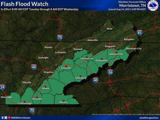 To coincide with the flash flood watch, WPC has issued a slight (10-20%) for nearly all of East Tennessee. Our far eastern tips also include a moderate risk (20-50%) of flash flooding today. The bulk of rainfall will be on the eastern side of the Appalachians, but run off combined with fairly saturated soils is a bad combination. 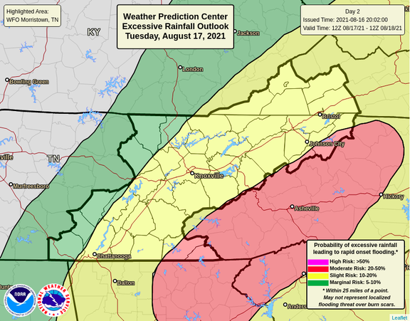 The rainfall outlook will range generally from 1-4 inches. Our far western counties will see the least impacts, while our eastern will see the most. As you can see, upwards of 5+ inches will be possible along the spine of the Appalachians today. This begins to drop off as you head further west. 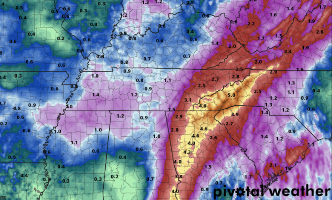 A bit of a lull will find us Wednesday as Fred exits north, but showers & thunderstorms quickly return for Thursday and the first half of the day Friday. Flash flooding will remain in question given the large amounts of rainfall through the past couple of days and expected in the days ahead. Pre-recorded for 5pm show
0 Comments
Scattered showers and a batch of moderate storms (Chattanooga) are falling this morning. These will strengthen some into this afternoon, mainly in areas that won't see much rainfall through the morning. A frontal boundary is working back north as Tropical Storm Fred is set to make landfall tonight and work north in the coming days. 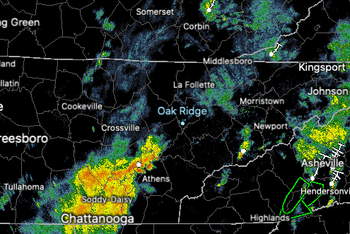 Looking at the WPC's expected rainfall, East Tennessee will range from 1 to 3 inches. My personal inclination would be for totals closer to 2-4+ inches, and that's only because of the rainfall expected today and with Fred towards midweek. Regardless, a slight risk (10-20%) of flash flooding is in place for our area each day through mid week. With moderate to heavy rainfall throughout the weekend and continuing into this morning, soils will continue to saturate, leading to flooding & flash flooding. Particularly low-lying areas (especially near water bodies) are most suited for this hazard. WIth that said, all should use caution as heavy rainfall could lead to ponding water quickly. It is noteworthy to also mention the path of Fred will make a big difference in how much rainfall we see. Models, in recent runs, have suggested a more eastward shift (good news for us) but things are likely to change so stay tuned for updates. 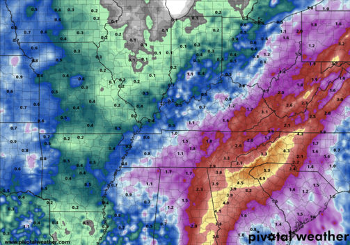 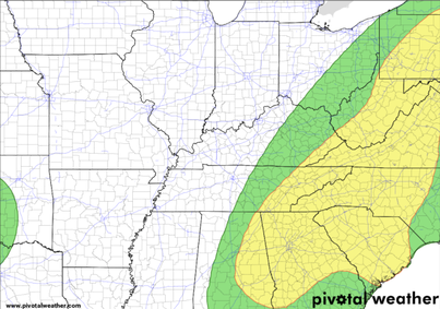 Looking at future showers/storms, they will continue this afternoon before we get a bit of a lull overnight. Fred will then enter the area (to our south) by tomorrow, bringing showers on and off through the day and again through much of Wednesday. As mentioned, Fred working more eastward would be the best case scenario for us, as a more westward shift would result in much higher rainfall totals.  With details regarding Fred still to be worked out, be sure to tune back in for updates. Follow us on Twitter/Facebook if you don't already (@SecretCityWx). Trends look positive, but guidance isn't truth and it will depend on how well the high off the Carolina Coast breaks down. The positive is we can at least enjoy some cooler air as well as some needed rainfall for our drier spots. Pre-recorded for 5pm show
As promised, relief from the heat is on its way. A cold front is progressing from the northwest and will arrive into the weekend. With it, widespread showers & thunderstorms will work through the area (some of which could be heavy at times). The combination of rain cooled air, cloud cover, and the front will bring afternoon highs into the mid and upper 80s.  Looking at now Tropical Depression Fred, the path remains relatively the same. Fred is expected to traverse just to the west of Florida before making landfall in the northern portions of the state and eventually turning east. It just so happens to work into the state of Tennessee, bringing tropical moisture to us by early to mid week. Changes are likely, but do anticipate to see some rainfall associated with Fred. 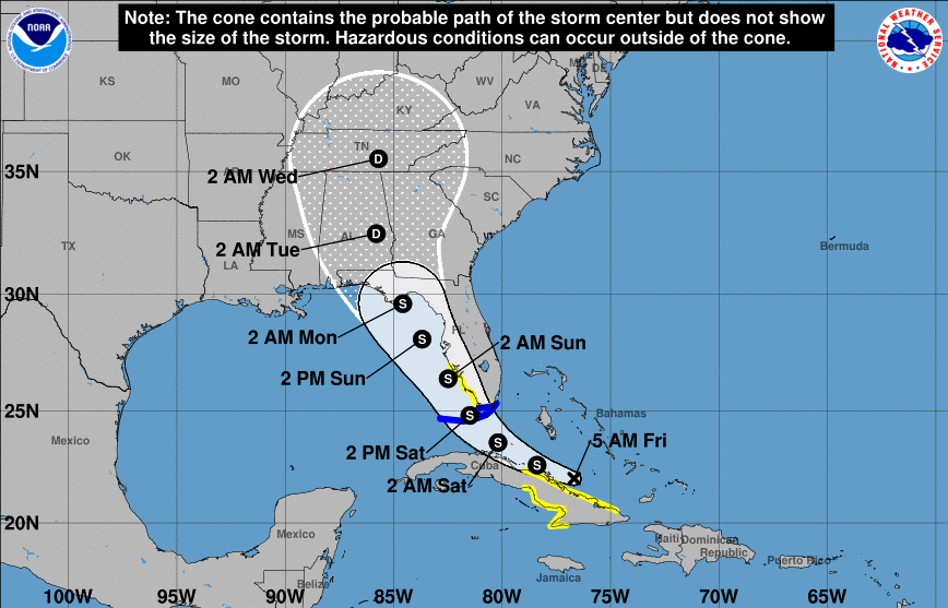 Looking at the 7-day expected rainfall totals, flash flooding could be an issue. With the passage of a front, daily rainfall we have seen through the week, and a tropical system working into the region, rising waters could pose an issue. We'll keep you updated ahead, but for now enjoy some cooler air across East Tennessee. 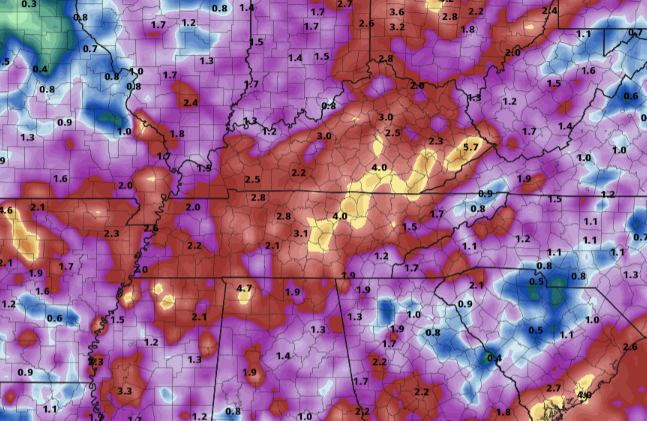 The latest drought map for this week remains relatively unchanged, so have decided to not include it in todays post. With all the rainfall expected over the next 7 days, I anticipate to return to normal conditions for much of the state by this time next week. Have a good weekend, stay dry, and don't forget to follow us on Twitter/Facebook. We'll be providing updates throughout Saturday & Sunday. Pre-recorded for 5pm show
High pressure remains locked in across the Appalachians today. Given the clockwise circulation of the system, areas to our west will feel the warmest. As seen from the expected heat indices this afternoon (from the NWS), Western TN could feel as warm as 115 degrees. Things are a little cooler at home with most locations feeling closer to 100. Continue to keep your heat safety in mind....some relief is on the way into early next week. 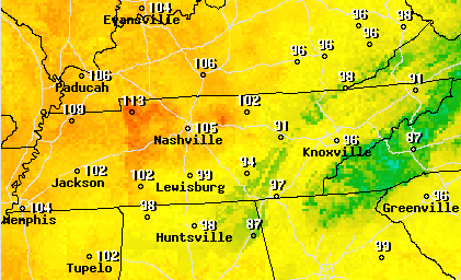 Fred, now a Tropical Depression, will keep working north and west. This system is expected to regain strength once through the Caribbean, potentially making landfall along Western Florida and into the Gulf States as a Tropical Storm or weak hurricane. This could also bring the opportunity for tropical moisture across East Tennessee by early to mid week. 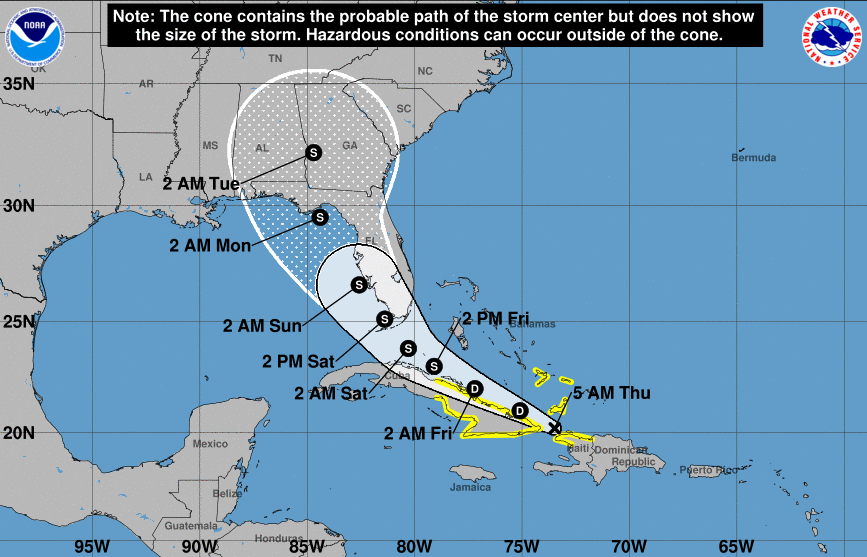 The theme remains very similar. Afternoon showers & thunderstorms then drying out into the overnight. We do have some changes arriving across the area by the early weekend, as a cold front will swing through bringing widespread showers and thunderstorms Saturday, Sunday, and into early next week (especially if Fred impacts the area). Gusty winds, lightning, and heavy downpours are the main hazards, but some storms could reach the severe threshold.  Conditions will remain very muggy through Saturday before the cold front knocks down temperatures across the region. We'll have the latest drought map for the state tomorrow, hopefully will some improving news. Thanks as always for your support and we hope to see you back here tomorrow! Pre-recorded for 5pm show
Brace for another hot and sticky one. These are the expected feel-like temperatures this afternoon and in the days ahead. With high pressure locking in warm temperatures, and southerly flow continuing to provide humid Gulf air, the heat won't let up until late weekend and early next week. 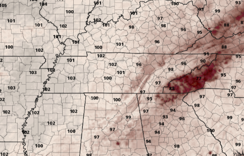 Diving into the Tropics, Tropical Storm Fred has formed and is expected to work northwest in the days ahead. Early indications suggest a chance for this to impact Florida and the Gulf states, but changes are likely. Stay tuned for updates and be sure to check back in over the next couple of days. 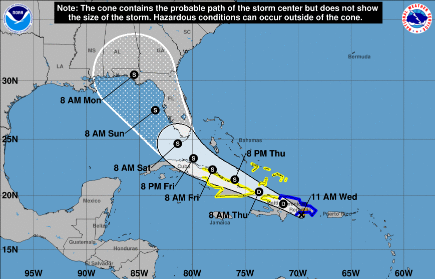 Here at home, daily afternoon showers & thunderstorms will continue. Toward the end of the work week and into the weekend, a cold front will slide through providing better chances for rain/storms. We will see a temps a couple of degrees cooler as a result, but things will unfortunately remain warm and muggy. The severe threat continues to remain low, though a few storms could reach those parameters. Gusty winds, frequent lightning, and heavy downpours will be possible at times today through the weekend.  Heat indices will make things feel closer to 100 degrees today and through the end of the work week, so stay cool, well hydrated, and don't forget to take breaks. There is a trend toward cooler temperatures, but that doesn't come until next week. Pre-recorded for 5pm show
It was a quiet but warm and muggy start to the day, but storms have developed early this afternoon. Satellite depicts afternoon cumulus clouds developing, along with scattered showers & storms. Highs will top out in the lower 90s for valley locations with feel-like temps closer to 100. Looking at the CPC's release of precipitation for mid to late August, above average rainfall can be expected, especially along the southeastern coast. 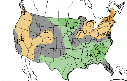 As for the next 5 days, rainfall will be limited just to the eastern third of the state. Rainfall amounts, according to the WPC, will generally be upwards of half an inch. Keep in mind this is an average for the entire area, so most locations will receive more or less depending on where storms form the next couple of days. 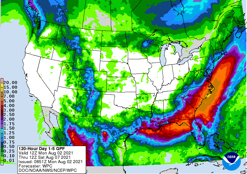 Speaking of storms, guidance continues to hint at the usual Summer pattern. Rounds of scattered showers/storms will be present each afternoon, dying out overnight. This will be the case through the end of the work week, before better showers arrive into the weekend and next week. Again the severe threat is low, but a few storms could reach those parameters. Heavy downpours and gusty winds will be the biggest threat each afternoon. 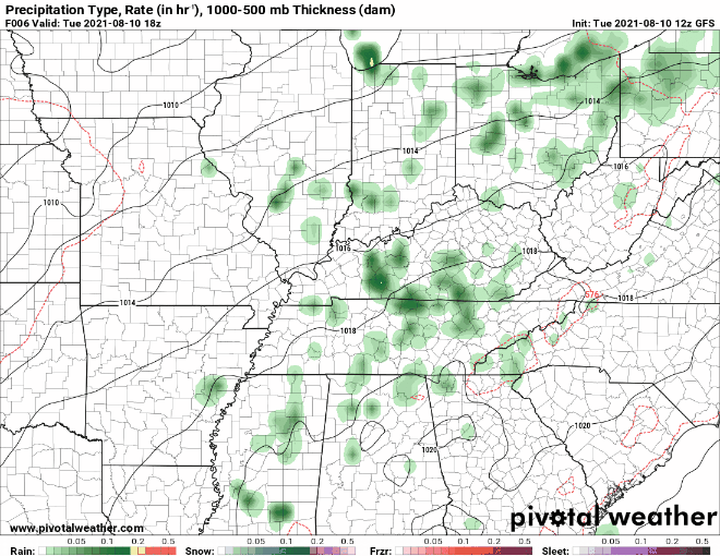 Be sure to check out our "Radar" tab for the latest activity across East Tennessee. Also don't forget to watch our video forecast below! Pre-recorded for 5pm show
Starting the new work week off with the Tropics, two disturbances are seen just north of South America. The red "X" indicates a greater than 60% chance of tropical development within the next 2 days, while the yellow indicates a less than 40% chance. That being said, a Tropical Depression is likely to form over the next day or so. 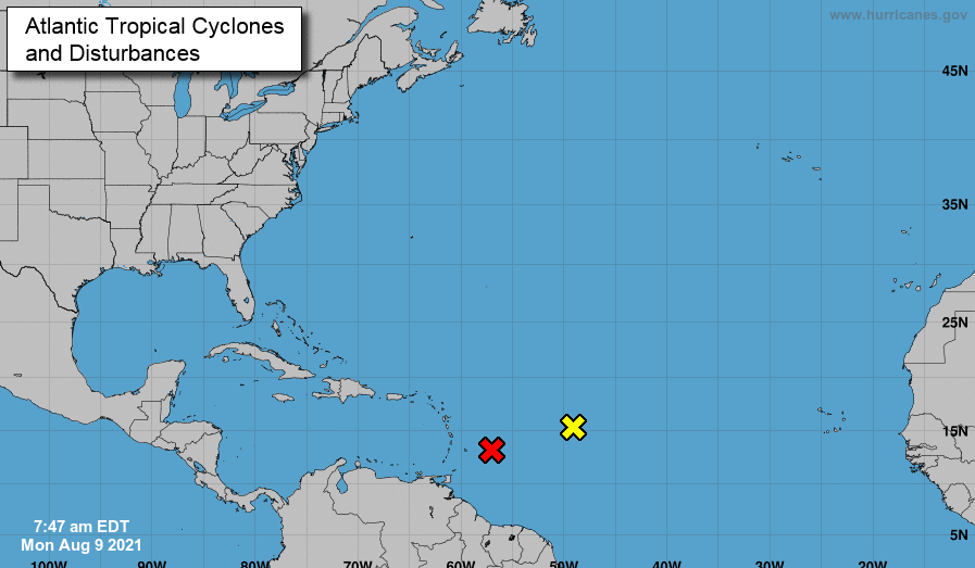 In additional to daily shower & thunderstorm chances, the heat and humidity will play a big daily roll. Looking below, feel-like temperatures are expected to be in the 105-110 range across portions of Middle and Western TN, and 95 to 100 range across East TN. Unfortunately, these will be the daily heat indices through the work week. Keep your heat safety in mind as it won't be a shock to see 100 degrees registered on the heat index today or in the days ahead. 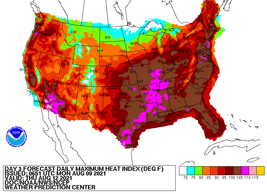 As mentioned, showers and storms will be possible each day. A series of upper level troughs will pivot across the region this week, bringing opportunities for activity each day. With precipitable water values fairly high (for this time of the year), we could see localized flooding in some storms. Confidence is low on any severe activity as well, but can't be ruled out (especially for the afternoon/early evening hours). Be sure to check in and have a way to receive warnings if any are issued. We'll provide updates via Twitter/Facebook so give us a follow if you don't already!  Unsettled weather will find us much of the week with heat and humidity to also be a bother. Do your best to stay cool, hydrated, and dry through at least Friday. Pre-recorded for 5pm show
Good morning! Checking out temperatures across the region from this time yesterday, we are trending much warmer. In fact, East Tennessee is running 5 to 10 degrees warmer. This trend will continue (with the exception of Saturday) as highs into early next week will be in the low to mid 90s.  Looking at the drought map for this week, conditions have stayed relatively the same. Recent rainfall over the past 7 days have been just enough to not add to the abnormal and moderate drought seen across the NE. Rainfall over the next 7 days looks to be limited, so we could see this worsen ahead. 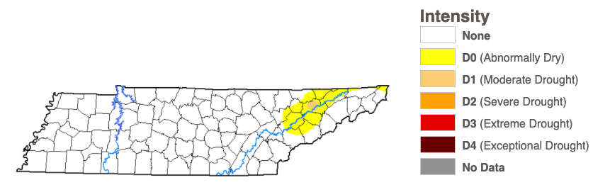 Model guidance depicts the usual summer-time convection. Afternoon showers/storms will be the trend over the next several days. These will typically begin in the afternoon and end by the evening as instability weakens. Saturday will likely be the best day for shower chances before high pressure arrives Sunday and into early next week.  That will wrap it up for today...for more information check out our video forecast below or our 5-day forecast. Have a great weekend! Pre-recorded for 5pm show
Views from the Stansfield webcam this morning depict patchy fog across the area. Take a little extra time this morning if you are on your way to work and/or school. This should begin to clear up within the next hour or two. 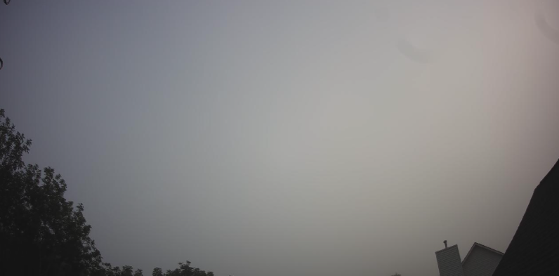 As for rainfall, it will continue to be few and far between. Upper level spokes of energy will bring daily rain/storm chances but those will be limited to the afternoon and early evening and scattered at best. We'll likely be our driest today with the "best" rain chances on Saturday. Again precipitation will be limited over the next 5 days with summertime afternoon pop up showers/storms the main story. 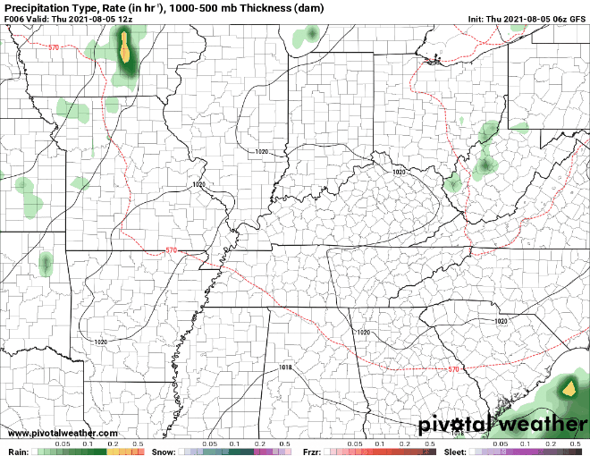 Moving forward, we have mentioned the warming trend expected in the coming days. Looking below, these are the expected heat indices nation-wide. As usual, the Tennessee Valley will be the warmest of the East Tennessee locations with feel-like temperatures likely between 95 and 100 degrees, Sunday and into early next week. We have been on the cool side the past couple of days, but don't forget about your heat safety as we move forward. 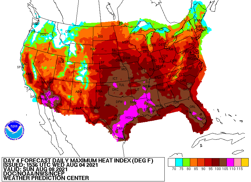 Today should be fairly pleasant for most with mostly sunny skies and highs in the mid to upper 80s. A stray shower or two can't be entirely ruled out for the higher elevations, otherwise most will stay dry today. Pre-recorded for 5pm show
Good morning and happy Hump Day! We start the day with a few light showers along the Foothills. Additional activity is expected this afternoon and early evening as an upper level wave passes the region. This will be the theme over the next several days as well. 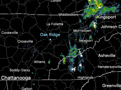 The good news for today is the lack of smoke in the atmosphere above us. We still have some particulates but much of this has worked south and west. Wildfires continue to burden much of the Western US and will likely continue through the late Summer and into the Fall. 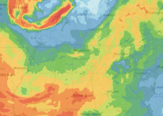 I hope you've enjoyed these seasonably cool temperatures, especially after our stretch of 90s. We will warm back up by this weekend as highs return to the upper 80s and low 90s Sunday and into next week. Dew points will also increase with southerly flow, leading to a sticky feel and heat indices in the mid to upper 90s early next week. 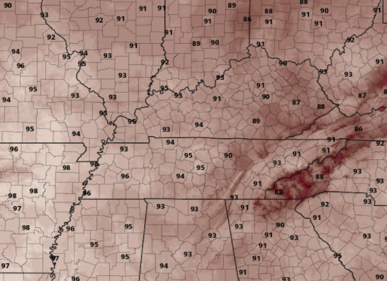 Other than a few scattered showers/storms through the day, things should be pretty comfortable. Highs will be slightly below the norm, topping out in the low to mid 80s. Pre-recorded for 5pm
|