|
Good morning! The latest 24-hour precipitation analysis shows the life-threatening rainfall for parts of Florida and Alabama. Due to the nature of this storm as its slow movement before landfall, some parts of this region picked up 10+ inches of rainfall in a 24 hour period. 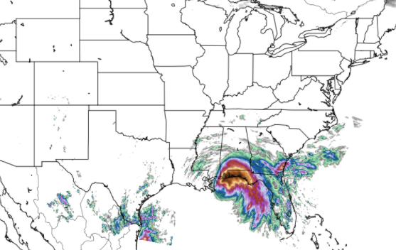 As what is left of Sally works north and mainly east, heavy rainfall will continue as depicted by the WPC excessive rainfall outlook below. A marginal risk for flash flooding covers most of east Tennessee today, so look out for those in flood prone areas. I still believe most of the activity will hang to counties far south and east throughout today. Specifically, counties like Polk up to Cocke will likely see the highest rainfall amounts before the day is over with. 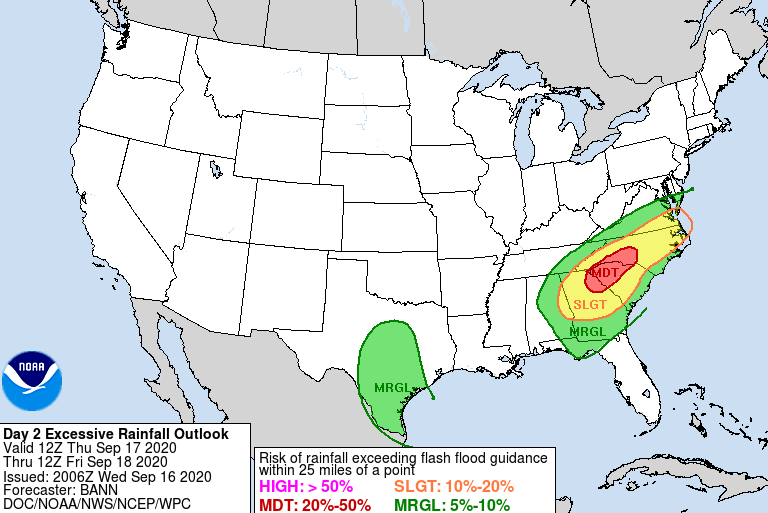 The good news is once Sally moves out tomorrow morning, we'll start to see some clearing taking place. A front to the west will force Sally eastward bringing drier and cooler air behind it. Showers will end early Friday, leaving the remainder of the day cloudy and cool. For Saturday, we will gradually clear out with sunshine returning by the afternoon and through Sunday and early next week. Comfortable to cool temperatures will also accompany with high's in the mid 70's and overnight low's in the low to mid 50's. A fall-feel is definitely upon us, so take advantage of the overall beautiful weekend we are expecting.  For more insight on the weather in east Tennessee, check out our daily video below or email us at SecretCityWx@aol.com for more information. We'll see a mix of showers throughout today before gradually clearing Friday and early Saturday.
0 Comments
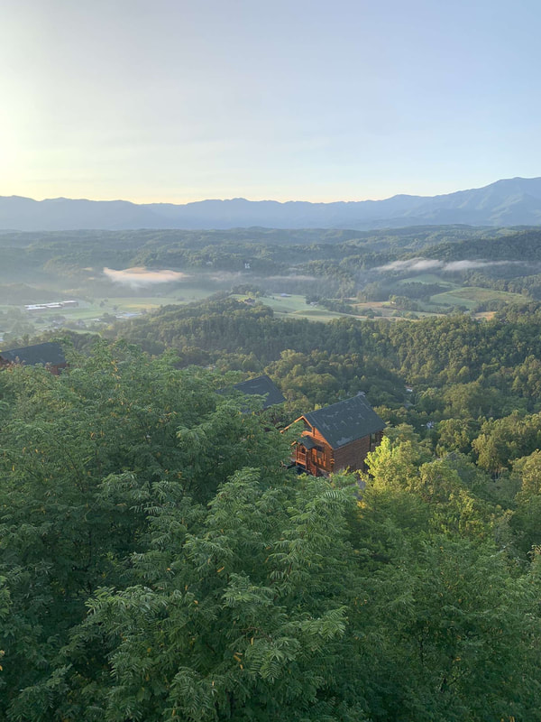
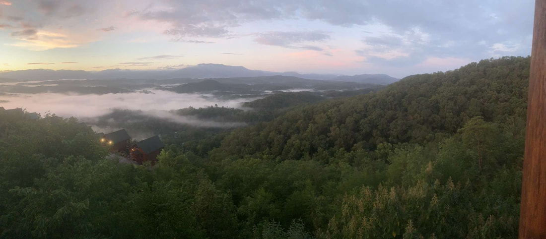
Sally has now officially made landfall in Alabama as a category 2 hurricane. Because of how slow she has moved the past couple of days, life-threatening flooding is expected in the Gulf. Sally is expected to work north and south, bringing the bulk of showers (here at home) to those farthest south and east. 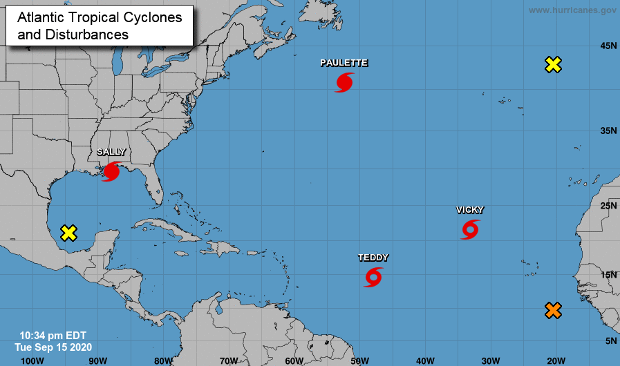 As seen here on model guidance, remnants of Sally will work through the heart of Alabama and Georgia. The northern edge of this system will likely bring showers throughout east Tennessee Thursday, with the heaviest and most widespread activity contained to southern and far most east Tennessee. By Friday, clearing will begin taking place the second half of the day. Sunny skies and beautiful fall-like conditions find us through the weekend and early next week.  Check out the low's across the region Saturday morning! With skies quickly clearing by Friday night, overnight low's will drop into the upper 40's and lower 50's. Saturday night into Sunday morning could be even cooler with mid to upper 40's possible. Either way, that cool fall feel has arrived so take advantage! 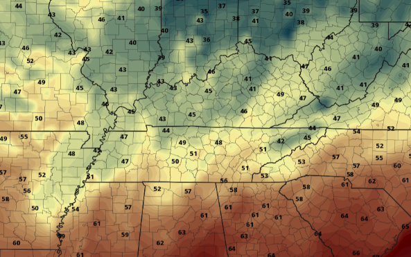 We will continue to eye Sally for rainfall amounts and impacts through the region. For now, be weary of the heaviest rainfall (& potential flooding) along the southern and eastern tips of east TN. Clearer skies work in later on Friday setting up a gorgeous weekend. The latest satellite shot shows Sally just off of coast, expected to make landfall near the Louisiana/Mississippi border. This hurricane was a category 2 yesterday afternoon but now has decreased to a category 1 (sustained winds of 85 mph). She will make landfall this afternoon before working north and east in the days ahead. 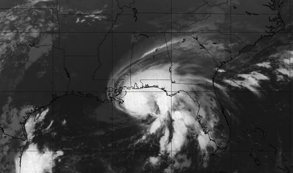 It is almost mind blowing to see the amount of activity in the Atlantic this week. In fact, there is only one more name on the list for the National Hurricane Center (Wilfred) before the Greek alphabet is used. Twenty-one, now Vicky, will work west before dissipating with time. Teddy will continue westward as well, giving the chance to make impacts to Bermuda later in the week. Keep in mind this is peak hurricane season and the official end doesn't come until the end of November (2.5 months). 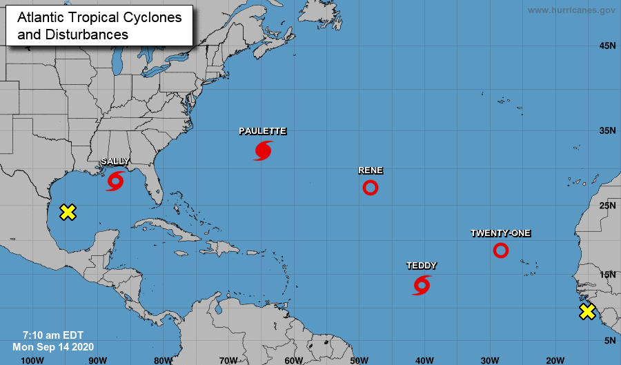 As Sally impacts the southeast, temperatures will stay cool through the end of the work week and the weekend. High's will be below average in the mid to upper 70's. Shower activity will be possible (mainly) Thursday and Friday with sunny skies returning for most of the weekend. If you don't have any plans yet, it would be good to make some! Sunny skies and high's in the 70's should dominate much of Saturday and all of Sunday. 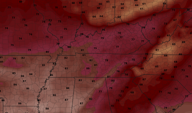 For more details on the path of Sally and how this could impact Tennessee, watch the daily video forecast below. That will wrap it up today though, hang in there as better conditions find us late Friday and into the weekend. Cloud cover lingers around this morning as a front stretches across the region. As we saw the second half of the day yesterday, a few scattered showers are possible throughout the first half of today. By tonight, clearer skies will work in leaving things dry and cool for the start of Tuesday. 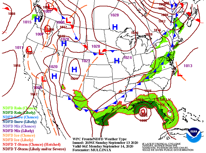 Another very active week in the Tropics with 4 named systems (Twenty is Teddy). A fifth is likely on the way (Just to the north of "Twenty"-> now Teddy) as strengthening is likely in the next 24 hours. Our main focus continues to be on Sally. As of this morning she remains a tropical storm but is expected to strengthen to a hurricane by the end of the day. This slow moving tropical system is expected to make landfall near the Louisiana/Mississippi border as a category 1 to weaker category 2 hurricane. The timing comes early Tuesday afternoon before moving north and east into Alabama and southern Tennessee. Rainfall chances will pick up mid to late week as this system works closer. 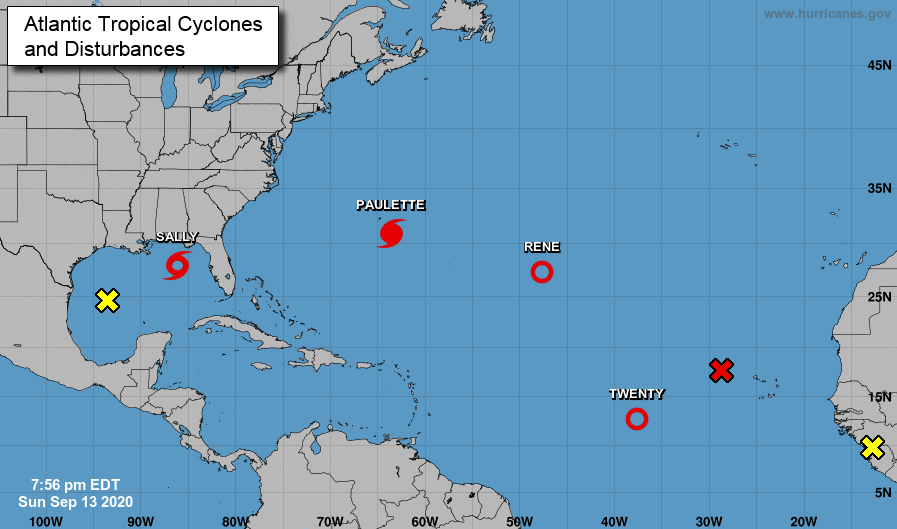 As for model guidance today, a few scattered showers are likely throughout with high's in the mid 80's. Clearer skies will work in behind the front tonight but won't stick around for long. As Sally draws closer, isolated to scattered showers are possible Tuesday and Wednesday afternoon. By Thursday and Friday, showers will be more widespread before drier air returns mid to late weekend. We will also see cooler temperatures across east Tennessee with high's expected to be in the mid to upper 70's the second half of the work week and into the weekend.  If you can make it through the first half of the day, much better conditions will find us this evening and overnight. Clear skies & patchy fog should start the day Tuesday morning before shower chances increase through the work week. Improvement continues across the state with only southeastern TN seeing abnormally dry conditions. With rainfall in the forecast this weekend, most of this area should return to near normal conditions. As for weather conditions today, they'll be very similar to yesterday. A mix of sunshine and cloud cover with a few showers developing in the afternoon (mainly higher elevations). High's top back out near 90 degrees with feel-like temperatures in the mid 90's. 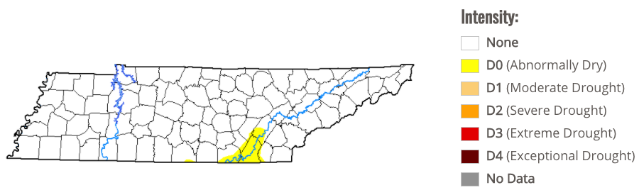 With September being peak hurricane season, we can verify the truthfulness with FIVE potential systems in the Atlantic. Two, of course, have developed into tropical storms (Paulette & Rene) but pose no threat for landfall. Far eastward, a wave off the coast of Africa will likely intensify through the weekend. The path and movement are much too early to tell but this will be something to watch for as we progress into next week. Closer to home, one system in particular is worth noting. A disturbance near the Bahamas (right of Florida) is expected to work westward crossing over the Caribbean and parts of Florida. By early next week, this will land in the Gulf where intensification could take place. The NHC believes the environment in the Gulf will be conducive for growth and a Tropical Depression can't be ruled out. We'll provide updates when needed! 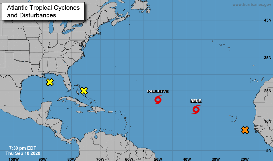 With a front still hanging to the north today, the bulk of activity will be north and west of the area. As we work into Saturday, this will work south providing better coverage (especially the second half of the day). Showers and a few embedded storms are likely throughout Sunday before becoming more scattered by early next week. Rainfall amounts vary throughout with the highest rainfall in the plateau. It is worth highlighting the WPC has labeled the eastern half of Tennessee under a marginal risk for flash flooding both Saturday and Sunday. Those of you in flood prone areas should use caution throughout the weekend. For the work week next week, scattered showers are possible each day with high's in the lower 80's.  Unfortunately, long term guidance hints back toward a warming trend for mid-September. For now I wish everyone a good and safe weekend. Do your best to stay dry as we'll more than likely see rainfall Saturday and Sunday. As we have seen the past few mornings and do again today, look out for patchy fog. As it begins to burn off by mid-morning, temperatures look to be warm again today. With the added moisture across the region, feel-like temperatures will be closer to the mid 90's this afternoon. Keep in mind our average high for this time of the year is in the mid 80's and we've been trending 4 to 5 degrees above that. 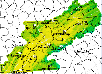 Better news (depending on how you look at it) is on the way. A nearly stationary front lies to our north and west and will gradually pull south by late Saturday. With it, we will see shower activity pick up and eventually cooler air work in late weekend and early next week. 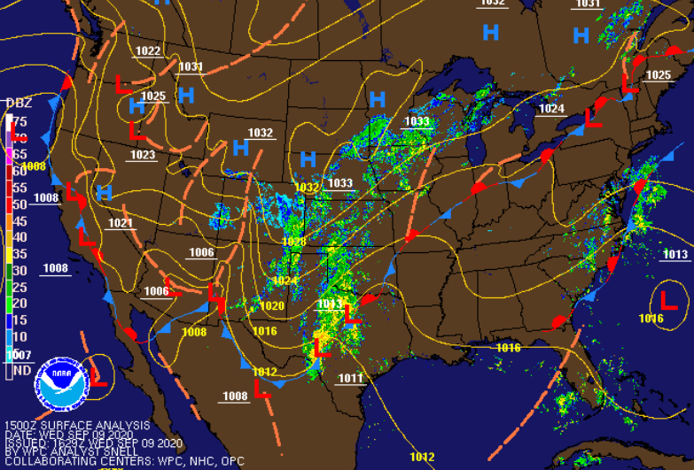 With the added humidity, a few isolated showers can't be ruled out today and tomorrow. Chances increase each day with the best rainfall chances Sunday. As the front works through, widespread shower (and a few thunderstorms) are likely late Saturday and through Sunday. This will also knock temperatures back down to near average before we warm back up later in the week. It will be interesting to see the release of the TN drought map as we have been dry with above average temperatures the past several days. I suspect only minor advancement in the areas of "abnormally dry" (Chattanooga & far western TN) but we'll provide more insight tomorrow. 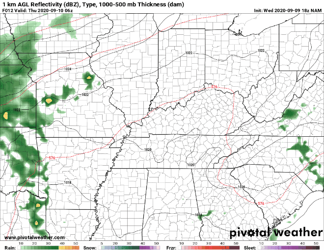 Don't forget to check out the daily video forecast below! As always, thank you for joining today and if Secret City Weather can help you, visit our "services" tab above or email us at SecretCityWx@aol.com Another beautiful morning to start the day with current temperatures (as of 7:30 am) in the mid 60's. We are seeing some patchy fog that has developed this morning, so be careful and give yourself a little extra time in some spots.  If we flip our attention back to the Tropics, an additional wave on the coast of Africa has a chance to develop. Latest guidance suggests this could work west through this week bringing trouble down the road. Of course, things are still very early and many changes are likely. As for the two named systems, they will head in a northward trajectory and weaken over the next few days. Lastly, an area of potential lies near Bermuda. As we mentioned yesterday, this cluster has an opportunity (30%) to organize in the next 48 hours before pushing westward. This one specifically could bring impacts to the Carolina's in the days ahead.  As humidity values climb back up through the day, shower activity will begin to spark back up as well. Things should stay mostly dry today around the area but a stray shower is possible on the eastern side of the Smokies. For the remainder of us, sunny skies with high's around 90. We'll see the chance for afternoon showers Thursday and Friday before better chances arrive through the weekend. A slow moving front will stall out across the region bringing cooler air and the likelihood for scattered showers each day next week.  With high's the next couple of days expected to be 6+ degrees warmer than average, make sure to drink plenty of water throughout the day. Heat indices are expected to be in the low to mid 90's for some so account for this if you are frequently outdoors. Good morning! I hope everyone enjoyed the extended weekend. Here are a few pictures to highlight the beautiful weather we had. Whether you were overlooking the Smokies or the Tennessee River, conditions were gorgeous either way.
As we transition back to work today, another active week is ahead for the Atlantic. Two Tropical Storms (Paulette & Rene) are active. The good news for these two is landfall isn't expected. They will work a bit west before turning sharply north. On the other hand, a wave near Bermuda (highlighted yellow) has the opportunity to strengthen in the next few days before working west. This batch could impact the Carolinas later this week, but final strength and intensity are too soon to tell. 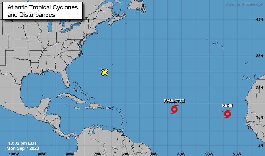 For here at home, we'll see another day of sunshine. Unfortunately, temperatures and humidity values will begin climbing back up. Afternoon pop up showers will also find their way back in Thursday and Friday with more widespread activity early into the weekend. A secondary, slow moving, cold front will arrive late weekend as well. Like the one from this past Friday, high's will be in the upper 70's to lower 80's across east Tennessee.  With things warming up, keep your heat safety in mind. We'll have lots of sunshine the next couple of days, so stay hydrated, cool, and don't forget the sunscreen. As we have seen the past few days, warm and muggy conditions will again be around today. A few showers will also mix in this afternoon before a cold front nudges in this evening/overnight. This will provide some much needed relief from the heat and humidity, as well as provide plenty of sunshine through Labor Day weekend.  To keep the good news train going, nearly all the drought in the state of Tennessee has vanished. The remnants of Laura did a good job bringing a majority of the state back to normal conditions. With a dry stent ahead, we'll keep an eye on changes over the next week. 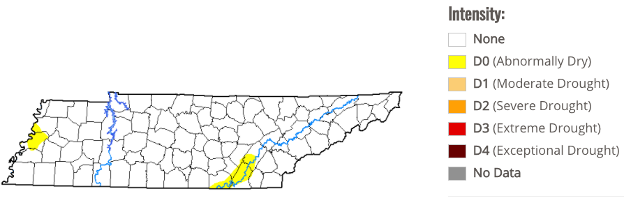 With respect to model guidance, there won't be much to talk about after today. We see a few light batches of showers this morning and a few more showers/storms will likely develop for areas this afternoon, but overall, there's little to talk about ahead. A high pressure system will nudge in behind the cold front bringing dry air and lots of sunshine. Longer term, temperatures and humidity will gradually crawl back up by early/mid next week before a secondary shot of "cold" air moves through.  That will wrap it up for today. If there is anything we can do to serve you, let us know by visiting our "services" tab or emailing us at SecretCityWx@aol.com. Have a great weekend and don't forget to share your outdoor experiences with us via social media or email! Things appear to start off pleasant this morning with partly cloudy skies over the Cedar Bluff area and temperatures in the lower 70's. As we advance through the day, keep in mind your heat safety. We will once again find feel-like temperatures in the mid to upper 90's, and for some, around 100. A few afternoon showers and storms are possible as well.  Looking at the latest surface map, we are positioned just north of a high pressure system. Luckily, a low to the north will provide relief by this weekend. Scattered shower activity is expected today and tomorrow (afternoon hours) before a cold front works through the region. We will see high's in the low to mid 80's through the weekend and plenty of sunshine. 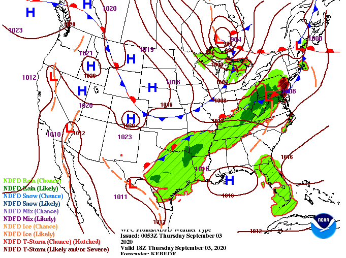 The bulk of shower activity today and tomorrow will be to our north and west. By Friday evening, a cold front will reach east Tennessee leaving overnight low's in the upper 50's and lower 60's Friday night and Saturday night. A high pressure system will also build in behind the cold front providing plenty of dry air and sunshine.  If you have the opportunity to enjoy some outdoor time with the extended weekend, take advantage! A second front will find its way into east Tennessee by the middle of next week bringing temperatures back down to the lower 80's. For now, keep your heat safety in mind, stay dry as there will be a few scattered showers today and tomorrow, and be on the lookout for cooler air this weekend. |