|
The Tropics remain very active this week with Nicholas dumping heavy rains across Louisiana and two other disturbances expected to form in the next 48 hours. Nicholas will linger around the south for a couple of more days before drifting north and east as a weak low. Given the southerly flow we have already, this moisture (from Nicholas) is making it into the region today and will allow for pop up showers/storms each afternoon (Thursday and Friday). 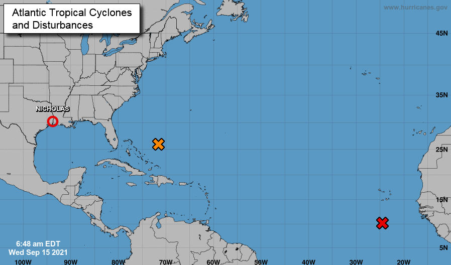 Into Saturday, another front to our north will look to bring showers and storms to the area. This one looks to stay out of the area, doing little to hamper the mid and upper 80s we'll see through the weekend. Most of the activity will be during peak heating of the day and fade with the onset of nightfall. Temps are on the cooler side of the average today, but will again increase into the mid and upper 80s by late weekend.  Other than a few isolated strong storms today, most will see hit and miss showers/storms through the evening hours. Tomorrow will clear up a bit with partly cloudy skies and isolated to scattered showers/storms in the afternoon. Pre-recorded for 5pm show
0 Comments
Nicholas strengthened to a Category 1 Hurricane before making landfall in Texas very early this morning. This system is expected to gradually (and I mean gradually) work east over the next couple of days, dumping heavy rainfall in portions of Texas and Louisiana. There is still some questions on how much moisture we see from this system, but some will get swept in with the cold front expected tomorrow. 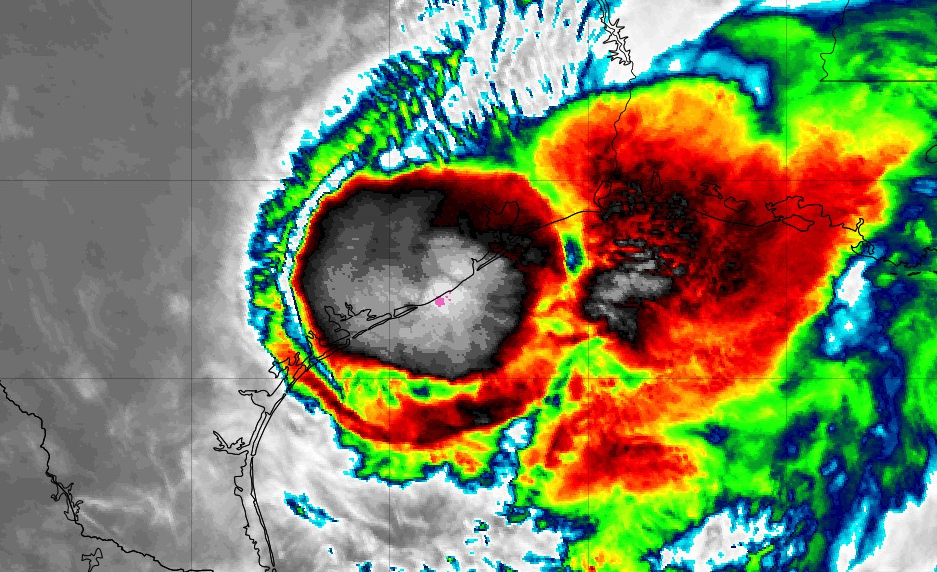 Looking at the SPC outlook for Wednesday, a marginal risk lies to our north (for now) as a cold front works east through the day today. Gusty winds, heavy rain, and lightning will be possible tomorrow, specifically in the afternoon hours. We could see this Marginal risk pushed down further south into parts of Middle TN/Plateau, with the biggest risk being damaging winds. 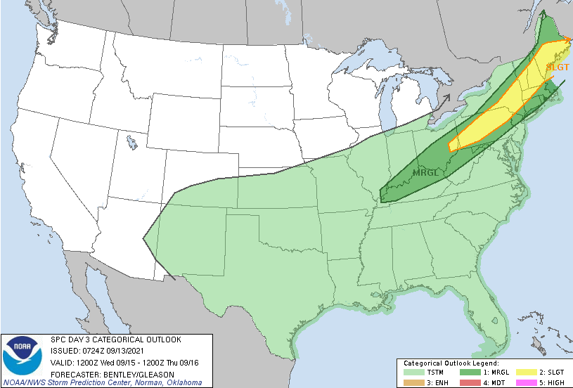 Running through model guidance, a bit of a change from the dry phase we have been in is planned. Isolated showers this afternoon will lead to scattered widespread showers/storms into Wednesday. A cold front will also allow for cooler temperatures with highs tomorrow in the low 80s. Additional showers/storms will be possible each afternoon through the end of the work week and into the weekend. Nicholas could also provide more moisture depending on how far north it travels. For now, a more eastward track is planned but another cold front will sweep this system in by the weekend.  For now, enjoy another mostly dry day. Showers and a few storms arrive back for Wednesday with additional activity expected Thursday and into the weekend. These will peak during the afternoon and fizzle out with the onset of nightfall. Pre-recorded for 5pm show
With high pressure just to our northeast and southerly flow dominating, temperatures will again be warm and muggy today. Comparing temps to the average for this time of the year, some locations could be as warm as 10 degrees above average. The average high in Knoxville for this time of the year is 84, and we are expecting highs around 90.  As we progress forward, rain chances return to East Tennessee. After a stent of nearly a week without a drop, a cold front and Tropical system will bring showers/storms to the area. Looking at the 7-day rainfall expectations, we could see anywhere between 0.25 and 1 inches of rainfall. This will depend on the track of Nicholas as well as the cold front working east. For now, not expecting any heavy rainfall this week, but scattered showers and a few embedded storms are possible each afternoon starting tomorrow. 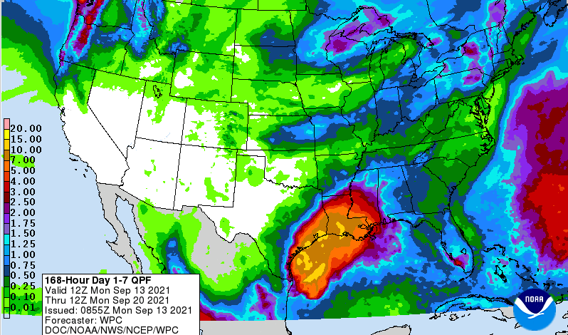 Looking at "future radar", isolated showers find us tomorrow before a cold front arrives for Wednesday. This will bring us our best chance of showers and embedded storms for the week with the aid of Nicholas to our south. Lingering activity will be possible each afternoon through the end of the work week and into parts of the weekend. Highs will stay on the warmer side, averaging in the mid 80s.  Nicholas is expected to make landfall tonight, bringing heavy rainfall to parts of Texas and Louisiana. This will slowly work northeast, bringing the potential for rainfall across East Tennessee in addition to the passing cold front midweek. We also want to mention the haze in the sky. Wildfires out west are producing smoke that is being drawn into the region (specifically to our west). This creates great sunrise/sunset colors but poor air quality for some. Pre-recorded for 5pm show
Good afternoon and what another gorgeous day it is! Comparing expected highs today to the average for this time of the year, we are running 2-8 degrees cooler. This, unfortunately, won't last too long as temperatures increase through the weekend and into early next week. 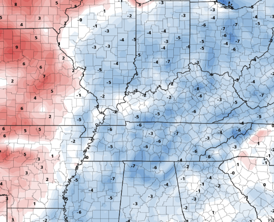 Taking a look at the CONUS drought map, the eastern half of the US remains fairly normal. Oppositely, the West is dealing with major drought and ongoing wildfires. With little rainfall expected in these locations, activity is likely to continue throughout the Fall. 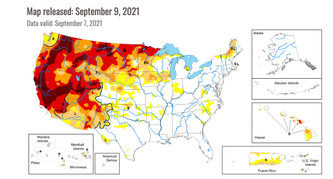 Overall, the weather ahead is pretty laid back. Sunshine will dominate through early next week with temperatures increasing Sunday and into the work week. Highs today are in the low 80s with upper 80s to low 90s Monday and Tuesday. Pre-recorded for 5pm show
With skies cleared out and temperatures below normal, it has been a gorgeous day so far. This view comes courtesy of the Great Smoky Mountain National Park. Be sure to get out and about today & tomorrow, as highs will be in the upper 70s and low 80s along with low humidity. 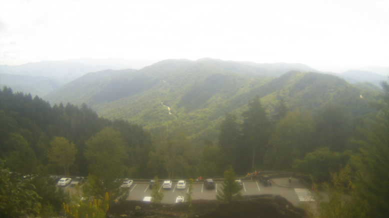 As you can see below, most of the Eastern US is running 5-10 degrees cooler this afternoon and with northerly flow in place, even cooler temps are in store for Friday. Working towards the latter half of the weekend, high pressure will shift east allowing for a more southerly component. This means increased humidity and temperatures Sunday and into early next week. 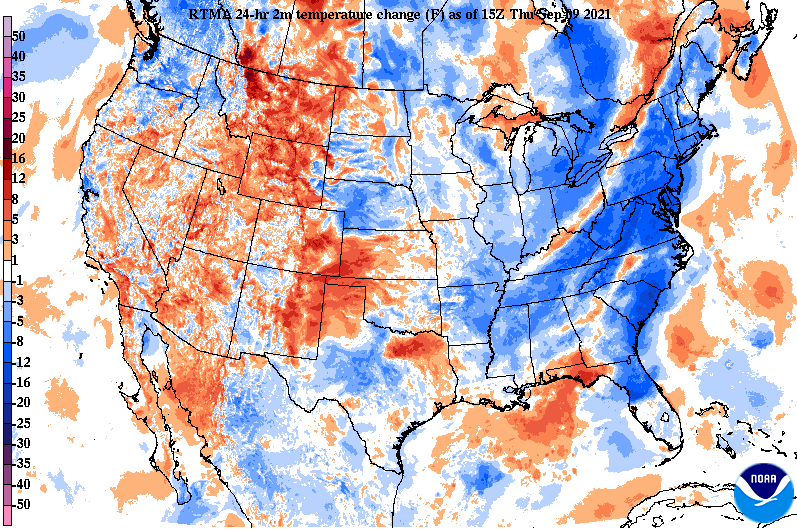 With high pressure dominating, there is little in the way of rainfall for the next several days. In fact, our next real rain chance doesn't arrive until Wednesday when a cold front pushes across the area. 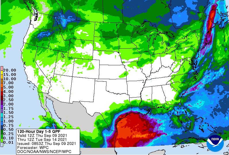 Enjoy this early Fall-like feel. September marks the beginning of meteorological Fall and I think Mother Nature has caught on to that....for now. Rain chances and increased temps/humidity arrive next week. Pre-recorded for 5pm show
Good afternoon! The Tropics remain active this week, as a disturbance in the Central-Gulf has a 40-60% chance of development. This system will work north and east, impacting the Gulf states, through Georgia, and eventually the southern east coast. In the Middle Atlantic, Larry continues to churn north expecting to pass just east of Bermuda tomorrow morning. 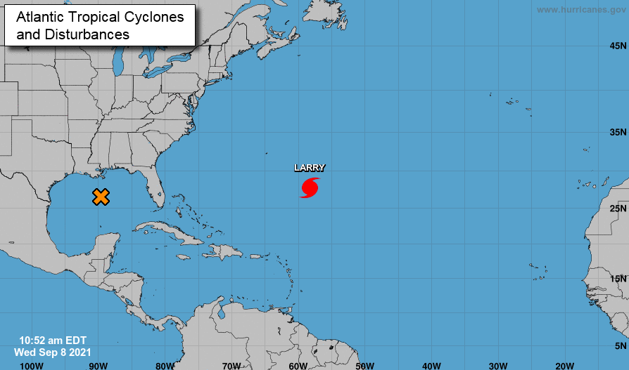 Turning our focus back toward East Tennessee, a cold front sits just to our west and it is not too hard to make out where. Much cooler air has filtered in through the Mid and Upper Mississippi and through parts of the Ohio Valley. This will continue pushing east, bringing cooler and drier air for Thursday. 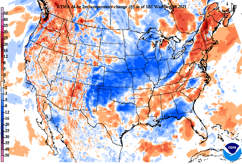 As the front pushes in, isolated showers will be possible at times this afternoon and evening. These should be pretty light, few and far between, and quick moving. As a result of the frontal passage, highs tomorrow will be in the low 80s with low humidity and lots of sunshine. 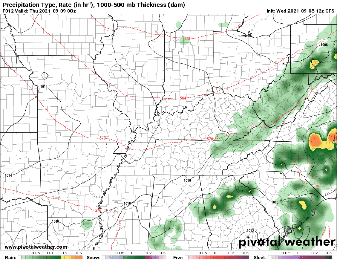 Go out and enjoy the Fall-feel tomorrow, as temperatures will be below average for this time of the year. Additionally, sunshine and near to slightly below average temperatures will continue through Friday and the early weekend. By Sunday, southerly flow returns, bringing higher temperatures and increased humidity. Pre-recorded for 5pm show
Looking live over Knoxville (~1:02pm), clear skies and a few stray clouds can be seen. Temperatures are currently around 80 and will increase a few more notches to top out in the mid 80s.  A cold front will make its way east-southeast, bringing increased cloud cover tonight and a chance for very isolated rain tomorrow. Given the lack of moisture with this system, it may be hard to see any showers at all. The best opportunities will be in the higher elevations. Pressing forward, high pressure fills back in from our west, bringing sunshine and cooler temperatures post-front.  The graphic below shows temperature anomalies. This means looking at forecasted temperatures and comparing them to climatological norms. As you can see, the entire state will be running cooler than average for Thursday. Near to slightly below average temperatures can be expected tomorrow and through the weekend, before things warm back up towards that 90 mark. 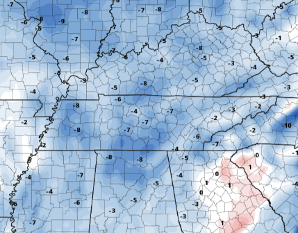 That will wrap it up for today, go out and enjoy the sunshine and average temperatures. A few isolated showers are possible tomorrow, so it wouldn't hurt to bring an umbrella just in case. Pre-recorded for 5pm show
Take a look over McCloud Mountain this afternoon! Skies are filled with a few fair weather cumulus and high cirrus clouds, with temperatures mild for this time of the year. As we work ahead, this will be the trend (besides Wednesday). 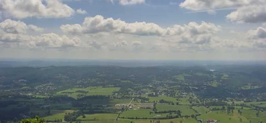 Another cold front will work out of our northwest and into the region. Given the lack of moisture associated with this system, isolated showers are possible at best. Even more so, the best opportunity will be along the higher terrain of the Smokies during the afternoon hours. Once this quickly passes, temperatures and conditions will be fair through the remainder of the work week and into the weekend.  Lastly, we wanted to update you on the improved drought conditions across the state. Many locations including NE TN experienced abnormal to moderate drought the past several weeks, but Ida did a good job of cleaning that up. Given the heavy rainfall we received, I don't think a several day span of mostly dry weather will impact the area too much. 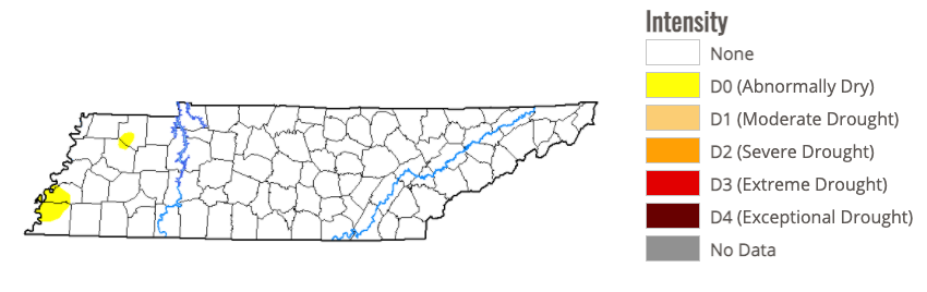 If you haven't already, be sure to go out and enjoy this beautiful day. Sunny skies will dominate a good portion of this whole week and with mild afternoon highs to accompany. Have a great Labor Day! Pre-recorded for 5pm show
Check out the current morning time temperatures! (7am) We haven't started this cool in several months, with most locations in the the upper 50s to low 60s. As a result of the cool morning start, highs will also be on the cooler side today. Highs will be in the low to mid 80s, a few degrees below the typical average for this time of the year. To make it all the more sweeter, another mostly sunny day is in store before a system arrives this weekend.  Another pleasant day is in the forecast for Saturday, though with some added cloud cover. A cold front will be working its way out of the Upper Mississippi Valley, bringing scattered showers and thunderstorms for the day Sunday. A few locally heavy downpours are possible, but it should be a pretty quick mover for the day. This will also keep temperatures mild into early next week with highs in the low to mid 80s.  Looking at the expected rainfall over the next 5-days, things look minimal. Other than a fairly weak system this weekend, rain chances will be limited to pop-up afternoon showers. Estimates of 0.1-0.25" are expected through midweek. 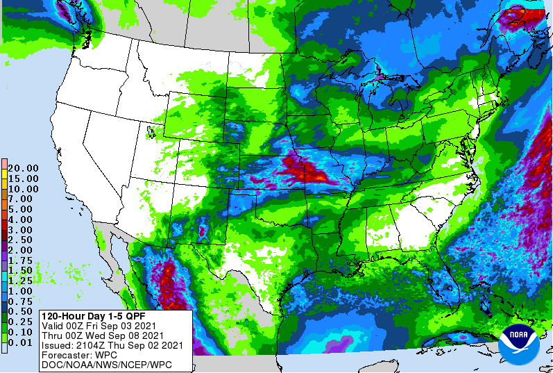 Enjoy a beautiful end to the work week with sunshine and comfortable temperatures. A front will work southeast mid-weekend, bringing scattered showers and a few embedded thunderstorms. It will also keep around near to slightly below average temperatures for the start of the new work week. Isolated showers will be possible Monday and Tuesday during the afternoon, but these will mainly stay contained to the higher elevations. Pre-recorded for 5pm show
Temperatures region-wide are much cooler this morning. With the passage of Ida and a cold front, we'll be experiencing below average temperatures the next several days. Additionally, a few more fronts will arrive for the period, bringing renewed relief to East Tennessee. 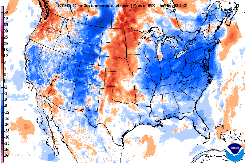 Looking into overnight lows tomorrow night, temperatures will be anywhere from 5 to 10 degrees below average. This is a welcomed sight for you Fall lovers, as lows will be in the mid and upper 50s tonight and again tomorrow. We will begin working our way back towards average, in the 60s, but enjoy the cool down that is expected. 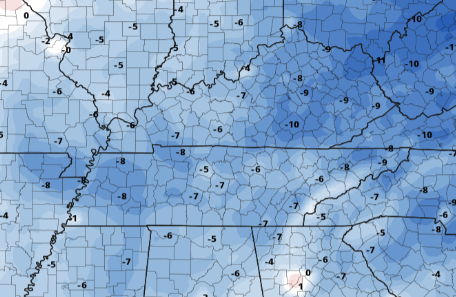 The forecast will be quiet the next couple of days with sunshine and highs in the 80s. We could see a stray shower Saturday, but the bulk of activity (scattered showers/storms) will find us Sunday with the passage of a cold front. Have a good one, and enjoy the lower humidity, cooler temperatures, and sunshine. Pre-recorded for 5pm show
|