|
Happy Friday! It will be another beautiful fall day out there with temperatures getting close to 70 this afternoon and mostly sunny skies overhead. This can all be thanked to the high pressure system we have sitting over the region right now. This will move out by tomorrow afternoon as a system to the south will bring showers overnight Saturday and through the beginning of the day Sunday. 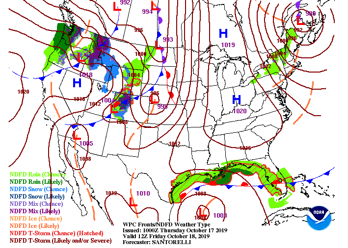 This system to our south is actually Tropical Cyclone Sixteen. It could develop into a category 1 this weekend, where it'll eventually travel north and east. Currently the storm has sustained winds of 60 mph and needs a minimum of 74 to be categorized as a hurricane. This is where we will see our shower activity from Saturday late afternoon and into Sunday morning. 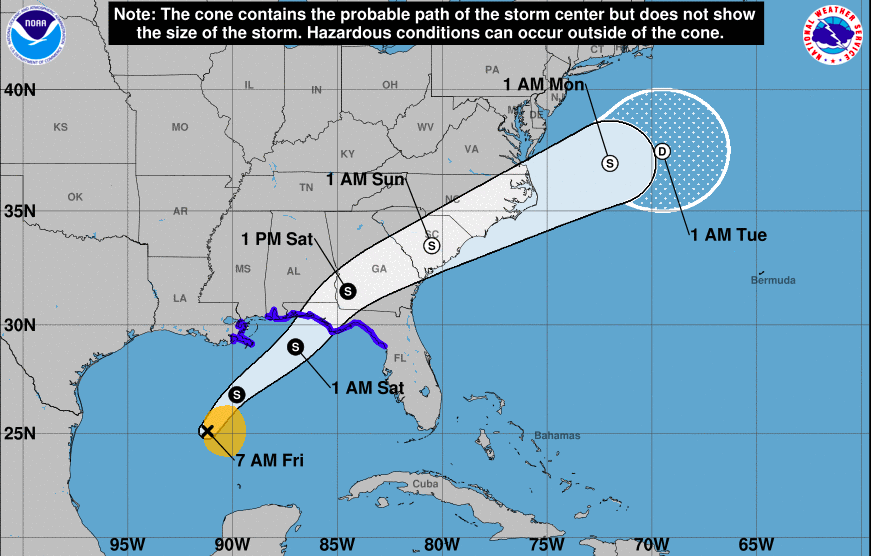 As you can see from model guidance, we will be feeling the impacts of the outer bands from this tropical system. Nothing severe or damaging is expected, but we could see up to a tenth of an inch here in east TN. The real rain maker is further to our west and will arrive Monday afternoon and through the first half of the day Tuesday. Showers and thunderstorms will likely bring up to half an inch of much needed rainfall early to mid next week. In addition to the rainfall, expect cooler temperatures back into the 60's, as well.  As always, have a great and safe day. Be sure to enjoy the beautiful conditions before rain and clouds move in the later half of Saturday and through Tuesday of next week.
0 Comments
Very dry conditions across east TN from the latest drought map (from this morning). Unfortunately, our next real rain maker won't arrive until Monday afternoon and into early Tuesday, so expect these conditions to slightly increase in severity over the next few days. Jumping into conditions this afternoon, expect it to stay cool with high's in the low 60's and mostly sunny skies. 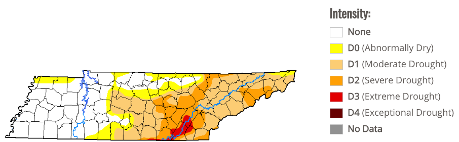 Our overall setup is with a high pressure system overhead. This will begin warming things up (near average) as we get into Friday and Saturday. By Sunday afternoon, we could see some isolated showers from a system to our south, but the main focus is Monday night when a system to the west moves through. We will likely see showers and thunderstorms with rainfall up to half an inch (much needed as we see). My mid-week though, we'll have clearing skies and temperatures beginning to warm back up into those 70's. 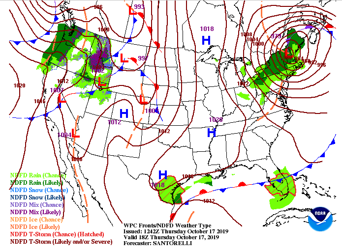 Looking at model guidance below for the setup, we see that low develop in the Gulf and move north. That'll bring isolated showers for the far most eastern part of Tennessee, but our real rain maker will arrive Monday afternoon into early Tuesday. For the next couple of days, expect to stay dry with sunny skies overhead and temperatures warming slightly each day. 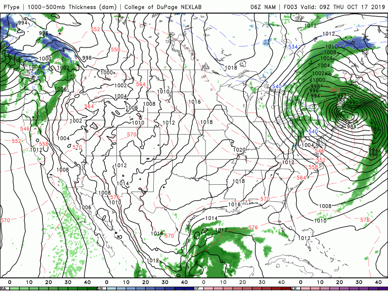 Thats all we have for you Thursday forecast, so enjoy these seasonal conditions. Sunny skies are quickly returning this afternoon with the passing of the cold front. That will allow for winds to shift out of the north and west this afternoon and cooler air to begin funneling in. Tonight will be chilly, looking at low's around 40 degrees. 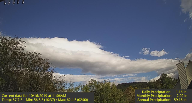 Stansfield Webcam (Oak Ridge) Heading into Thursday, it'll remain cool. High's are expected to be in the low 60's with mostly sunny skies overhead. Luckily, a high pressure system will slowly work in by Thursday afternoon, allowing for warmer temperatures to settle by Friday and into the weekend. 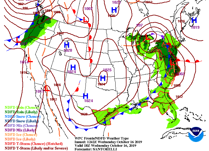 With the cold front moving out, drier air is settling in allowing for those clear skies and crisp temperatures. This will continue through the early weekend before our next rain maker arrives early next week bringing another round of showers and cooler temperatures. Model guidance below shows a few of those light showers in the higher elevations later this afternoon, but those will clear out by the evening hours.  To wrap up your Wednesday forecast, expect skies to continue clearing this afternoon and temperatures to stay in the low 60's to upper 50's. This will lead to a chilly overnight and another cool start Thursday before we slowly start warming back up into the 70's. Don't forget to check out our video updates below and have a good day! Cloud cover will continue increasing into this afternoon as a cold front to the west draws closer. The rain will hold off until the overnight hours, allowing for a dry commute home tonight. For this afternoon expect highs in the mid 70's and mostly cloudy.  The latest surface map shows the cold front to the west and shower activity out ahead of it. This will make its way into our area overnight and into Wednesday before another high on the backside pushes in for the remainder of the work week and into the weekend. With this cold front expect temperatures to fall throughout the day tomorrow starting with our high in the morning hours (mid 60's) and falling to the mid/upper 50's by the afternoon. Showers will decrease along with the temperatures allowing for sunny skies to return later in the day tomorrow. 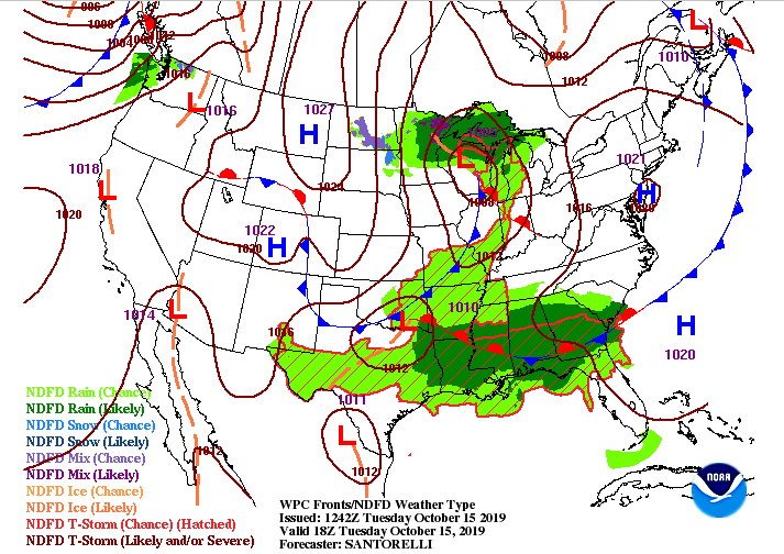 Model guidance shows the cold front making its way in overnight with showers ahead of it. Don't rule out scattered thunderstorms within this system but no severe weather is expected (overall good sleeping weather). For the morning commute tomorrow, account for scattered rain showers and wet roads. By the afternoon we will dry out and clear out allowing for sunshine to move back in the remainder of the day and week. In total, we are expecting between 0.25 and 0.5 inches of rainfall across the region. This will help the overall drought we have been dealing with but we are going to need more before we get back to "normal" conditions. 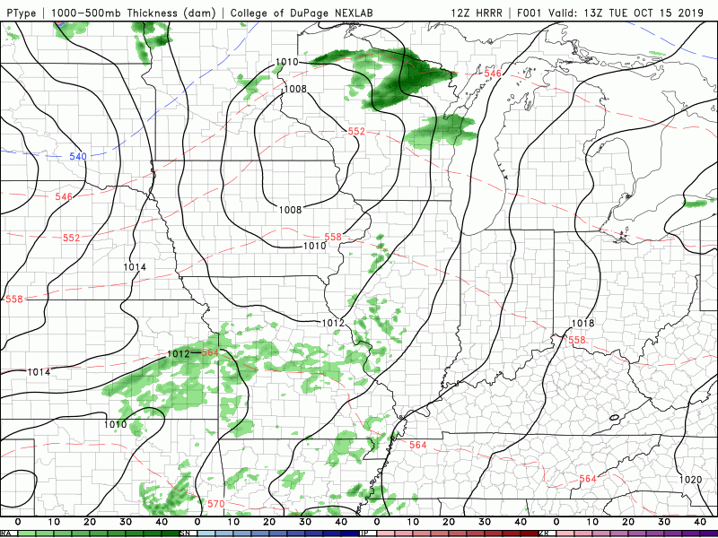 Stay dry as we get into Wednesday as there will likely be some left over showers in the morning. Cooler temperatures will progress through the day as the cold front works through so dress accordingly. After tomorrow we will begin warming back up and drying out before our next weather maker arrives late this weekend and early next week. I hope everyone was warm for the chilly start we had this morning. We will have more in the coming days as another cold front will move through mid week. For today though, a high pressure system will keep things comfortable and dry through much of the day tomorrow. By tomorrow afternoon, a cold front will begin creeping into the area, bringing with it scattered showers overnight and into Wednesday.  As you can see below, we will continue staying dry today and through the early half of Tuesday. Once that cold front draws near, shower chances increase Tuesday night and into Wednesday morning.  Drawn out below is the cold front to the west by 2am Wednesday morning. We will likely see scattered showers throughout the night Tuesday (maybe a rumble of thunder or two) before cooler air begins funneling in through the day Wednesday. Expect temperatures to decrease throughout the day as that colder air moves in. We will reach our high Wednesday in the EARLY morning hours before we start the temp decline. Once the cold front passes, you'll know, as sunny skies will return (by Wednesday afternoon). 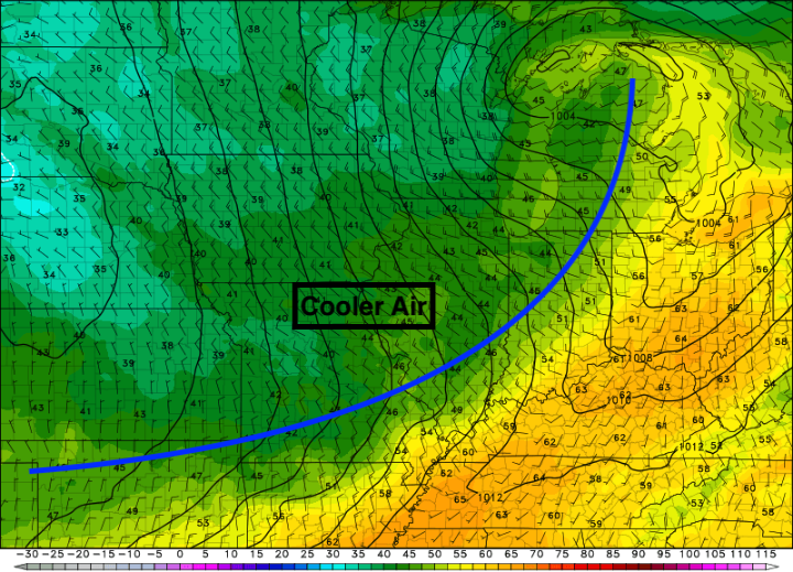 Thats all we have to start your work week but you can check on your full 5-day forecast in our "Weekly Forecast" tab, as well as our detailed forecast below. Have a great day! I hope everyone is having a good Friday thus far. If we first look at the 24-hour temperature change across the US, check out these differences to our west! Anywhere from a 30+ degree change from this time yesterday for North Texas and Oklahoma. A very strong cold front will make its way through tonight and into Saturday for our area. 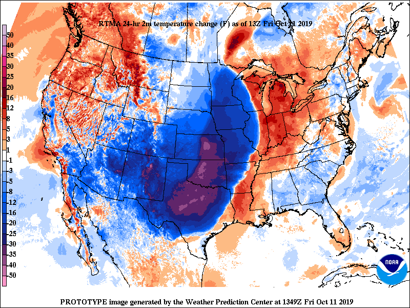 As for right now, the high pressure system will keep things above average and dry this afternoon before the cold front to our west moves in. With it, expect light scattered showers for Saturday and much cooler temperatures. Once this move out Saturday afternoon, another high pressure system to the west will dry things out for Sunday and early next week. 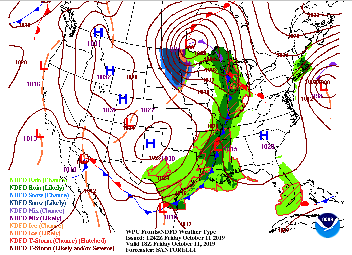 Plans to cheer on your local high school tonight? The good news is we will stay dry for the game with temperatures starting in the mid 70's and ending in the mid to upper 60's by games end. Cloud cover will begin increasing late this afternoon and evening, providing mostly cloudy skies overnight. 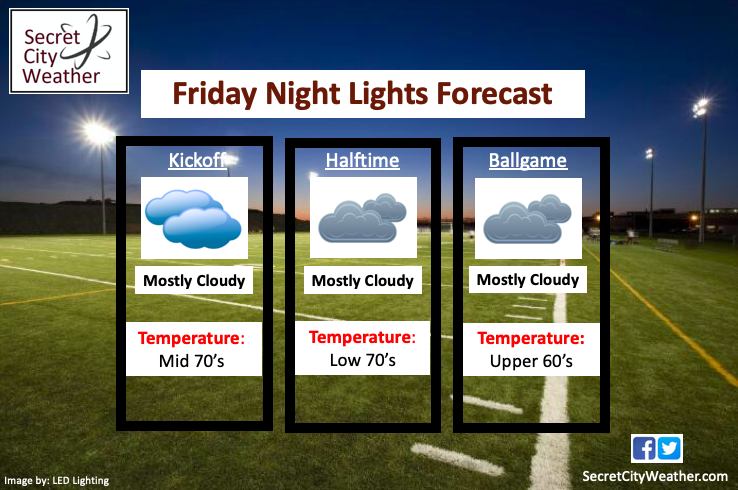 Working into tomorrow, we will see some scattered showers begin moving in late tonight and early Saturday. These will move out rather quickly (by early afternoon) before we start clearing out for Sunday. If you plan to attend UTK vs. Miss. State, plan to dress warm and bring a rain jacket as temperatures will be in the upper 50's for kickoff and we could see some light scattered rain showers.  The later half of your weekend looks gorgeous, so take advantage and enjoy some outdoor activities. Thats all we have today, but have a good Friday and great weekend! Happy Thursday; one more day before the weekend! Until then, changes are coming. We will stay above average today into tomorrow, before cloud cover builds tomorrow afternoon. A high pressure system will keep us dry and warm today and tomorrow before a cold front moves through the region. We will see some scattered light rainfall Friday night into Saturday morning before quickly clearing out for Sunday. 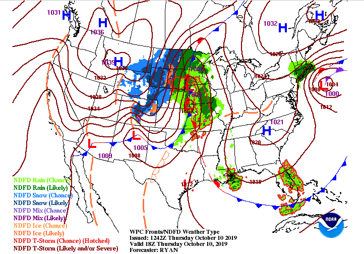 Looking into tomorrow, check out this swing in temperatures from East TN to West TN. Note, this is at 4 tomorrow afternoon, typically thought of "as the warmest time of the day". We will be sitting in the low 80's while west TN in the upper 50's. Thats nearly a 30 degree temperature difference across the state due to the cold front! This will slide through Friday night, knocking high's to the mid 60's Saturday and low's in the 40's overnight. 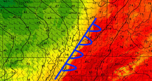 The high pressure system will keep things dry this afternoon, but as the cold front approaches, so does some rainfall. This won't be a wash out, just some scattered light showers (40% chance) Friday night into Saturday. By Saturday afternoon, clouds will begin decreasing as a high pressure system moves in allowing for a BEAUTIFUL Sunday and Monday (Mostly sunny and high's in the low to mid 70's).  Remember to check out our video forecasts below. If you enjoy our content, we would love for you to share with friends, family and/or on social media. I hope everyone has a great Thursday! It was another cool morning with temperatures in the upper 50's. We will warm up this afternoon though with high's in the low 80's. We are stuck between two systems, feeling a weak high pressure system that will keep us dry to Friday afternoon. 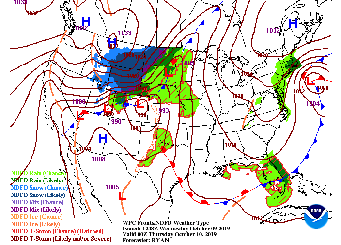 As we work into Friday night and Saturday, a cold front will make its way through the area. Ahead of the front, expect light scattered showers before cooler, drier, and clearer skies return for Sunday. The Fall-like feel will be in full force this weekend, so make sure to go out and enjoy it! We will be looking at high's in the low to mid 70's for Saturday and Sunday, and low's in the mid 40's at night. 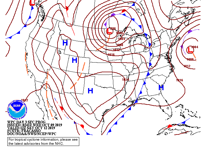 Little to discuss on model guidance as we will stay dry the next few days. An isolated shower can't be entirely ruled out for the higher elevations this afternoon, but overall expect the valley to stay dry through Friday. 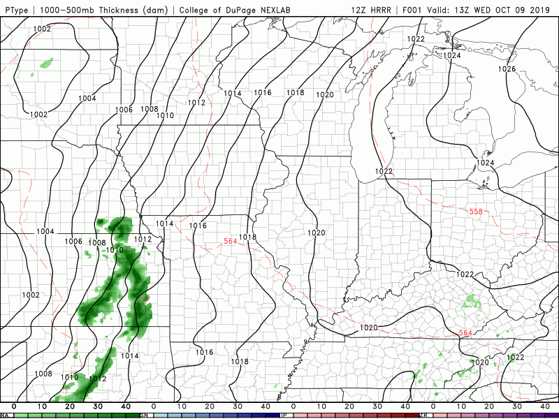 Thats all we have for your Wednesday forecast, but don't forget to checkout our video updates below. These provide a more in depth analysis for what you can expect now through the weekend. Good afternoon everyone! I will start by looking at the second half of the month below. The CPC (Climate Prediction Center) has continued their outlook of above average temperatures, as well as above average precipitation. The precipitation side is good, as we are still dry across the area. Temperature-wise we will get back into the low to mid 80's next week (around 7 degrees above average). 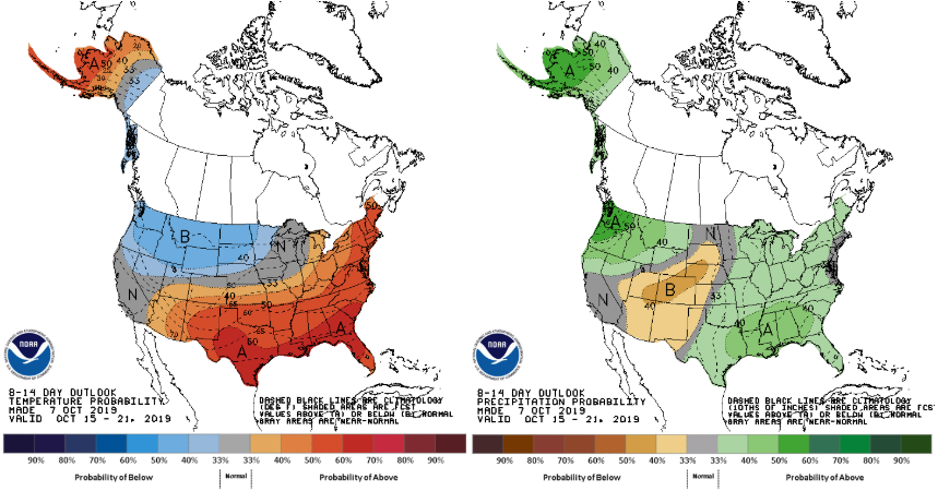 Getting closer to home for the forecast this week, the cold front is funneling in cooler air from our north, allowing highs in the mid 70's today. Behind this front is a high pressure system (already beginning to clear things out to our west) that will bring sunny skies and warmer temps into Wednesday. This high will keep things dry and warm for the remainder of your work week until another cold front slides through late Friday. We could see another round of light showers Friday night into Saturday before cooler temperatures stick around for the weekend. Expect highs Saturday and Sunday in the low to mid 70's and overnight low's in the mid 40's. 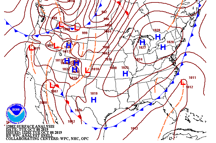 Model guidance hints at a light shower or two this afternoon and into the evening hours. Expect this to be limited to the higher elevations, as we are already beginning to clear out this afternoon for the valley. Getting into Wednesday and Thursday, sunny skies and warmer temperatures are to return with the high pressure settling in the region.  I hope everyone has a great Tuesday and enjoy the comfortable temperatures and sunny skies returning tomorrow. We started wet and dreary this morning, but given the extremely warm and dry conditions we have faced, I'm sure many of us will take it. Those rain showers are continuing across the valley into the lunch time hour, but will begin to thin out by later this afternoon. 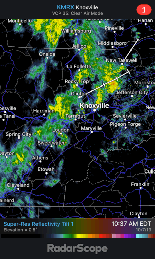 A cold front is continuing to slide through the area, dropping temperatures 8+ degrees from this time yesterday. Temperatures will continue to fall throughout the day as the front slides through. Tuesday will be a bit cooler with highs in the lower 70's. 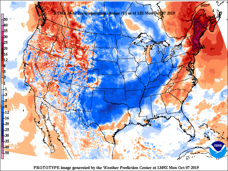 Model guidance shows the cold front working through, as well as the rain associated with the low to our north. This system will move out rather quickly as a high pressure system will work back in Tuesday afternoon and stick around through the remainder of the work week. Note* Another winter-like system to move through the rockies and upper midwest later this week, bringing us much cooler temperatures into the weekend and a chance for some rain Friday into Saturday. (looking at highs in the 60's and lows in the mid 40's Saturday). 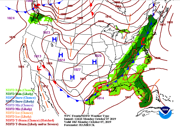 The latest model guidance shows the light to moderate showers throughout east TN. As we get into the afternoon and overnight they will become more isolated, eventually clearing out by Tuesday afternoon and welcoming back some sunshine. Mostly sunny skies to remain through Friday before the next system from Canada works in to the north.  Thats all we have on your Monday, stay safe and dry the remainder of the day! |