|
We have veered dry through late this morning, but showers are starting to fill in gradually as we have crossed the lunch-time hour. Activity will become widespread by the overnight hours and into Saturday, with even a few rumbles of thunder possible. Those that see repeated rounds of showers/storms could pose localized flooding risks, but the overall chances are low and confined to mainly the southern valley. Cooler air will trail this system, bringing temperatures to near seasonal norms on Sunday (low to mid 50s) and then warming right back up into early next week. Much of the upcoming week appears dry and seasonably warm. Enjoy and take advantage if you can! Pre-recorded for 5pm weather broadcast
0 Comments
Dry weather today, but it won't come without plenty of cloud cover. That said, some slivers of sunshine will give way later this morning and into this afternoon, before high clouds fill back in thereafter. Our next round of rainfall arrives into Friday, with widespread showers and a few storms tomorrow into Saturday. Flooding/flash flooding will remain possible, particularly for the southern valley, but confidence in this occurrence is overall low. The good news is we'll see drier and cooler weather find East Tennessee by the end of the weekend, before warmer air filters in early next work week. Pre-recorded for 5pm weather broadcast
A soggy morning across East Tennessee, with light to moderate showers falling. This should taper off by the early afternoon, with all activity coming to a close by tonight. Highs will be cooler as a result of the showers and clouds, with highs in the lower 60s. A mostly dry day is in the works tomorrow, before the atmosphere recharges for another round of rain (and few storms) Friday into Saturday. Isolated flash flooding will be a concern with this later one, with pockets of heavy rainfall possible. Be weary if in flood prone areas Friday and Saturday, especially for the southern valley. Cooler temperatures and sunshine build back in on Sunday. Pre-recorded for 5pm weather broadcast
Showers build in today, bringing widespread rainfall by tonight. Activity will diminish through Wednesday, with generally drier weather later Wednesday and through much of Thursday. Temperatures will remain above normal through this time. Another late week low pressure system and associated cold front will then bring widespread showers and a few thunderstorms Friday into Saturday. The potential for flooding with this later system is possible, but low at this time. The southern valley, nearer to Georgia, will have the highest threat of rising waters and/or flash flooding potential. A Marginal flash flooding risk is in place, but I would not be surprised to see a Slight risk introduced along the border of GA Friday into Saturday. Pre-recorded for 5pm weather broadcast
Have the umbrellas handy all week. Our driest days will fall today and Thursday, while Tuesday, Wednesday, Friday, and portions of the upcoming weekend could be quite wet. A series of disturbances will pass through the region, bringing bouts of showers, (maybe a few thunderstorms), and at times the threat of heavy rain. Friday into Saturday will be the biggest threat for heavy rain, as some locations (particularly the southern valley) could pick up one to two+ inches. The 7-day total overall will vary between 1 and 3 inches, with 2-4" more likely for the southern valley. With the warm season quickly building in, be weary of thunderstorms and their influence of dumping heavy rainfall if they occur. Pre-recorded for 5pm weather broadcast
Pre-recorded for 5pm weather broadcast
After the passage of a cold front, it'll be chilly again today with highs in the upper 40s to low 50s. Similar conditions are in store to end the work week tomorrow, in addition to widespread rainfall that is expected to fall. Thankfully, if you can make it through this, a warming trend finds us this weekend and into next week. Highs warm back well above average, in the 60s or 70s. An unsettled weather pattern finds us next week, with a series of disturbances passing by near to just south of the state. Pre-recorded for 5pm weather broadcast
Pre-recorded for 5pm weather broadcast
Unsettled weather in the plans today and especially Wednesday, with a series of disturbances passing through the area. Thursday will turn very briefly dry, before yet another weather system passes through bringing rainfall to the area Friday. In total, rainfall amounts today through Friday will vary between an inch to an inch and a half. This higher end range is to account for any thunderstorms we see, particularly tomorrow afternoon to early evening. We will begin to finally dry back out, in a longer duration, this weekend to early next week. Highs will remain very spring-like today, peaking in the upper 60s, before falling Wednesday into Thursday back into the lower 50s (more seasonal). Keep in mind as well, winds will be gusty today into Wednesday. Those in the higher terrain, plateau/foothills/smokies, will see the highest gusts, with up to 45 mph possible for the plateau and well over 60 mph possible in the Smokies. Winds will begin to slacken through the later half of the day Wednesday. Valley locations can expect sustained southwest winds of 15 to 25 mph and gusts up to 40 mph. Pre-recorded for 5pm weather broadcast
Good morning! We are off to a very warm start, with morning temperatures in the mid 40s to low 50s (well above average). This can be thanked to the "blanket" of low clouds beginning to scatter out- eventually resulting in plenty of sunshine by lunch time. With a very warm air mass in place, anticipate little changes between the above average start and highs this afternoon, with many pushing 15 to even 20 degrees above the norm. High temperatures to peak in the mid to upper 60s today and last in this range through midweek. 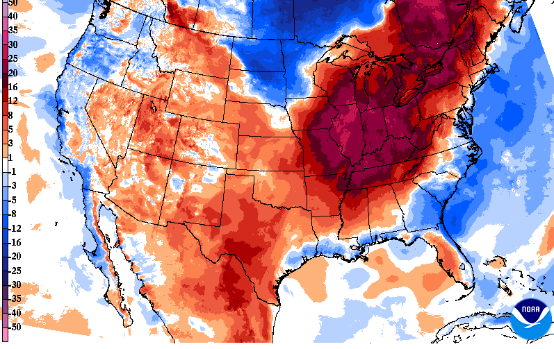 In fact, looking below, you can see how warm things are expected to be compared to average. This snippet from guidance indicates we could be as warm as 15-20+ degrees above the norm Wednesday afternoon. Keep in mind our usual average for late February are the lower 50s and we'll be averaging values closer to mid April numbers. The good news is a "big" cool down is in store, bringing us temperatures around average by Thursday and Friday. 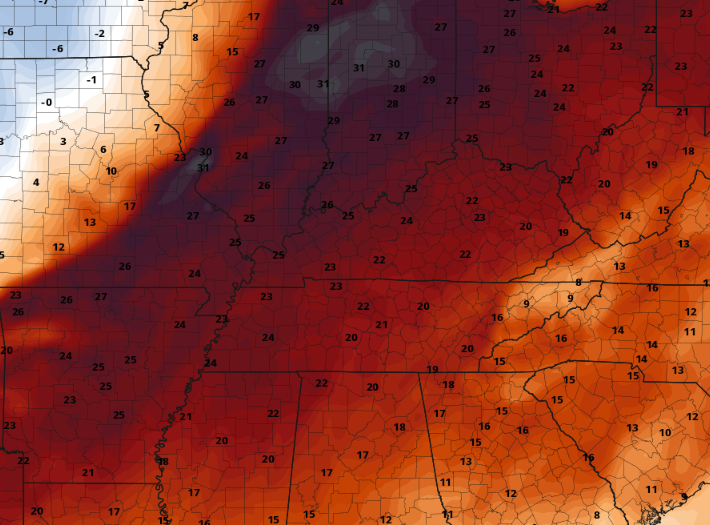 Speaking of that cool down, a series of disturbances look to bring rainfall first. Isolated to scattered showers find us late tonight through Tuesday, followed by the approaching cold front Wednesday into Thursday. This later (Wed-Thu) system is expected to bring widespread showers and possibly a rumble of thunder, along with a brief wintry mix chance on the tail-end of things. Breaking it down further, the frontal boundary will slide east, resulting in breezy and widespread showers Wednesday into Wednesday night. As colder air funnels in behind the boundary, lingering moisture could be in the form of a rain/snow mix or isolated snow/flurries. Impacts are not expected across valley locations at this time, but the higher terrain could see some white stuff to start off the day Thursday. 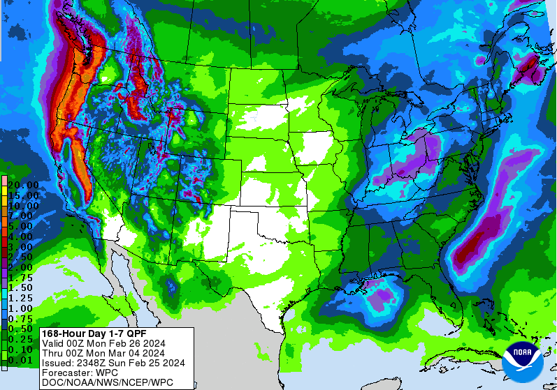 That will do it for today...Enjoy one last day of dry conditions, above normal temperatures, and sunshine because unsettled weather followed by cooler temperatures arrive tomorrow through the end of the work week.
|