|
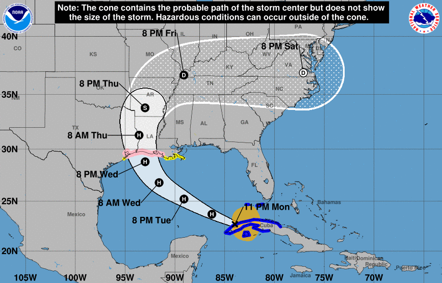
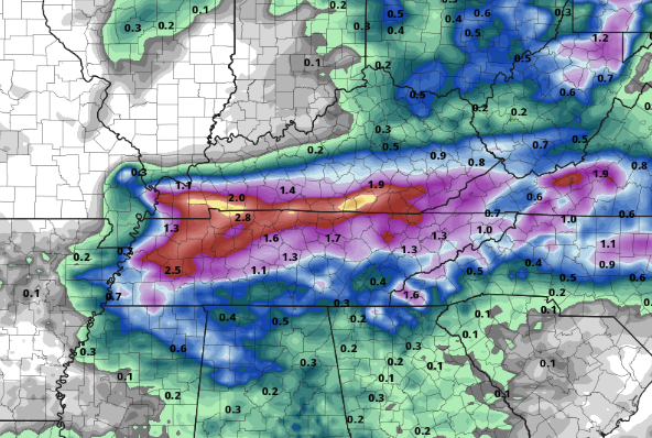
A beautiful morning is underway with a mix of cloud cover and sunshine. Current temperatures sit in the lower 70's, but changes come this afternoon. As the day carries on, anticipate high's to top out near 90 degrees with heat indices closer to the mid 90's. Stay cool and hydrated once again today as heat related illnesses can strike quickly. The latest update in the tropics doesn't look to be a pleasant one. As Laura begins to work into very warm Gulf waters, development into a major hurricane looks more promising. For reference, a major hurricane is defined as a category 3 or higher. Just when you thought 2020 couldn't get worse, how about the chance for a major hurricane to slam our Gulf states and then bring tropical depression winds and rainfall to Tennessee? Well, that's a bit more realistic than a fiction story. The latest trends have Laura pushing northward before cutting east. Since yesterday, the path has been pushed a bit more south, bringing heavy rains throughout Tennessee and Kentucky by the weekend. We will keep a close eye as this evolves, but definitely be aware of the possible impacts as we work towards the weekend. Today and the next few days will mainly consist of a few pop up showers/storms and warm and muggy conditions. The main focus, as described above, is Laura. The latest model trends show Laura staying north of east TN. Many changes are likely in the forecast so take these trends with a grain of salt. With that said, this particular model shows rain totals in the 2"-4" range for southern Kentucky and northwestern TN. Here at home, things are closer to the 1"-2" mark. Again, with the unpredictability of tropical systems and a how this will morph in the midlatitudes, we'll continue to provide updates in the days to come. With Laura on the table, check in frequently for updates in the days to come. Even if we get a bit more lucky and Laura works north of the area, we will likely still deal with gusty winds and heavy rainfall. For now, do your best to stay cool and enjoy your Tuesday.
0 Comments
Leave a Reply. |
Your trusted source for everything weather in East Tennessee.
Social Media
|


