|
Pre-recorded for 5pm weather broadcast
0 Comments
Much warmer this afternoon, though it may not feel like it, than this time yesterday. Temperatures will continue to trend warmer over the next couple of hours, peaking in the upper 40s to around 50 degrees. We'll continue to trend warmer in the days ahead, with highs finding the 60s this weekend. Shower chances also return, with widespread rainfall Friday and scattered shower chances through the weekend. 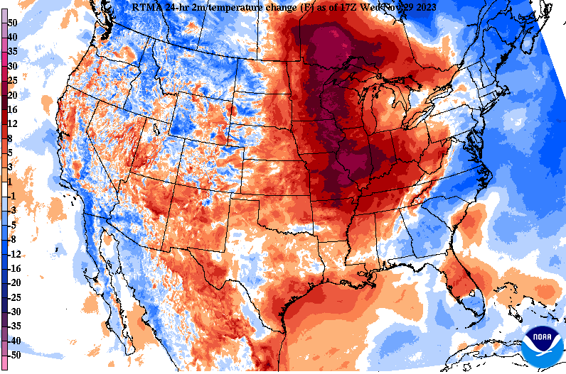 Enjoy a pleasant day today and much of tomorrow (with even warmer temperatures), before unsettled weather returns Friday and through the weekend. Check out our video forecast below for more information. Chilly across East Tennessee, but we'll see a warm up in the days ahead. Showers are back in the forecast as well, arriving Thursday night and lasting at times through the weekend. Check out our video update below for more details. Pre-recorded for 5pm weather broadcast
Good afternoon! It's been a chilly start and there won't be much change tomorrow either. Looking at the latest 24-hour temperature map, dark blues indicate temperatures on a magnitude of 10 to 15 degrees cooler than this time yesterday. With the passage of the cold front, below average temperatures can be expected through Wednesday morning. 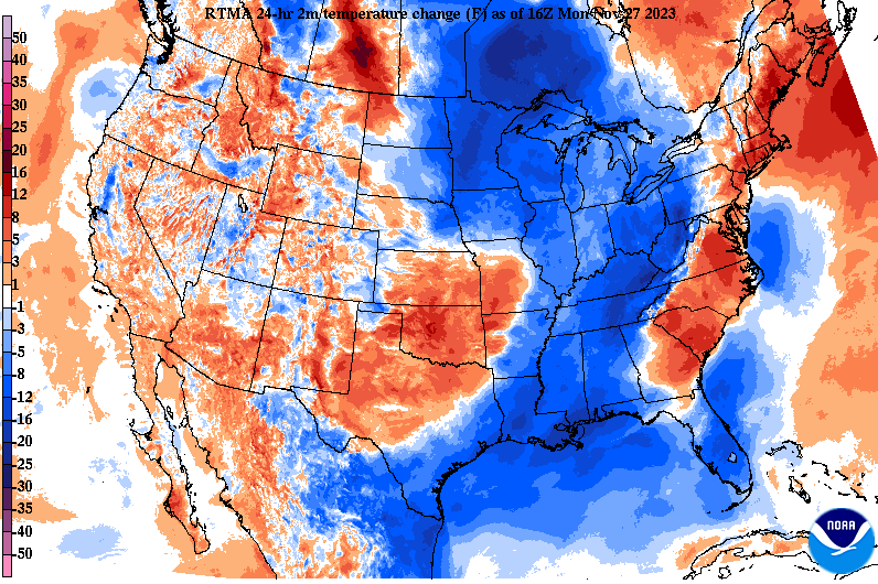 Looking at those temperatures outside, many are struggling to top 40 degrees as of 12:30 pm. With low clouds slow to thin out, it has been hard to warm up. Fortunately, the last of low clouds are almost out, allowing for a few hours of sunshine before we drop into the low and mid 20s overnight. In fact, some areas could bottom out in the teens. 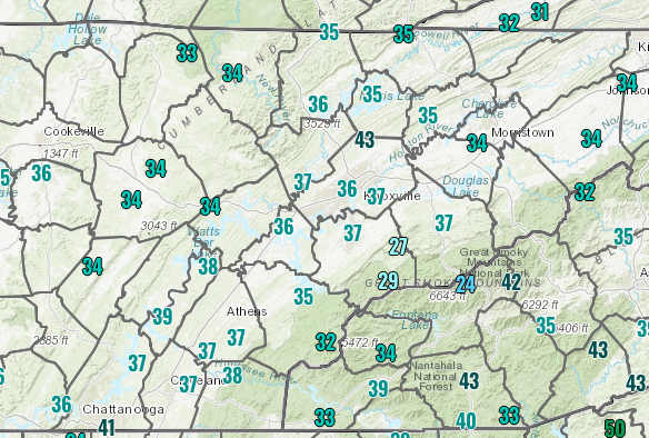 Similar to today, highs tomorrow are expected to remain below average. Comparing potential temperatures to typical late November highs, we are expecting values 10 to 15 degrees below average. Highs Tuesday should top out in the low to mid 40s, with even colder overnight lows Tuesday into Wednesday. Lows Tuesday night will generally fall into the teens and low 20s area-wide. Bundle up the next few days!  The good news is after tomorrow, we'll begin warming back up towards average. Highs Wednesday should find the lower 50s, improving to the mid 50s on Thursday. A late week disturbance will then look to bring the return of showers, which last into the weekend. Timing for rainfall will generally come late Thursday night and lingering at times through Friday night/Saturday morning. A healthy shot at rainfall (still much needed) is expected. Pre-recorded for 5pm weather broadcast
*It's happening* Some much needed rain has been falling across the Volunteer State, as many locations have picked up three-quarters of an inch or greater as of 1 pm. Most should end up between 0.75" and 1.5," though locally higher amounts are possible. This will help the very dry conditions we have maintained for several weeks, but we still need more to erase the drought moving forward. 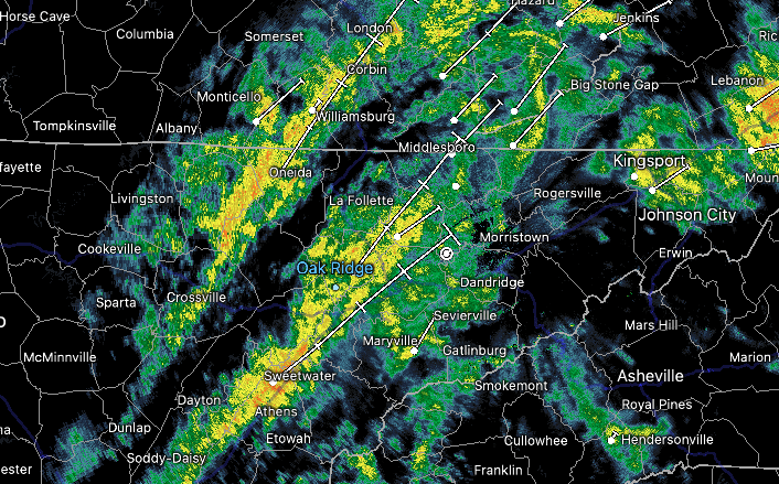 Image as of 12:50 pm A low pressure system is working through the area now, dragging a cold front east of the area by tonight. This will allow for showers to taper off from west to east and pull in cooler air from the west. As you can see upstream, lots of blues indicating much cooler air than this time yesterday and that'll be the case for us tonight and into Wednesday as well. Highs will fall 10-12 degrees cooler tomorrow than compared to today (around 50 degrees), with a gradual rise to near average Thanksgiving Day and through the weekend. 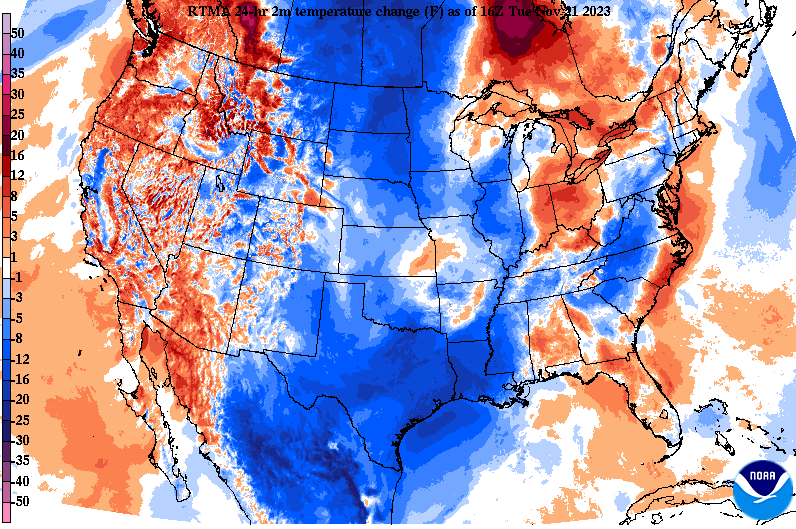 A few isolated showers will remain possible tonight into the first half of the day Wednesday, followed by passing high pressure that'll contribute to dry weather Thanksgiving Day. Another passing disturbance could then bring isolated shower chances Friday, with cloudy skies lingering into the weekend. Check out our video forecast below for more information! Several things to discuss, so we will jump right into it! MUCH needed rain is on the way! A strong autumn low pressure system is expected to pass by through Tuesday, bringing a widespread soaking rainfall. This should be our much needed "drought buster," but more rain is needed to get back to normal. As far as what can be expected, generally cloudy through today, with a few sprinkles at times this afternoon. Showers really begin ramping up late this evening and through the night, with widespread rains into Tuesday (don't forget the umbrellas tomorrow). Activity will taper off tomorrow night, with lingering showers possible with a second disturbance on Wednesday. High pressure then fills back in, bringing dry weather Wednesday night and Thanksgiving Day.  Healthy rainfall amounts are in the forecast, with amounts between 0.75" and 1.5." This will really help the exceptional drought (4/4) in the southern valley and extreme drought (3/4) much of the state faces. Unfortunately, it won't be reflected until next week's release. That said, it should take us to great lengths, with the exceptional drought likely coming off the table later next week. We will also have the opportunity for a few other hit and miss showers Friday to early Saturday as well. 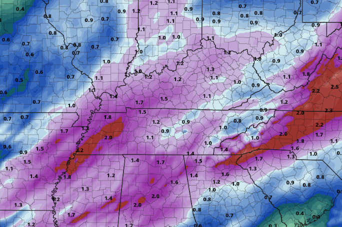 Another aspect of this forecast, aside from the widespread rain, will be winds. This system will allow for a breezy overnight and Tuesday, with gusts varying across East Tennessee. Here is what you can expect depending on your location: Smokies (under a high wind warning): sustained 15-30 mph, gusts up to 75 mph Valley: sustained 5-15 mph, gusts up to 35 mph Plateau: sustained 10-20, gusts up to 50 mph Winds are expected to increase overnight, peaking into Tuesday morning before petering out through the rest of the day from west to east. Check out what the strong gradient does for possible wind gusts on the image below. (The image below is NOT a forecast, but a simulated model run) 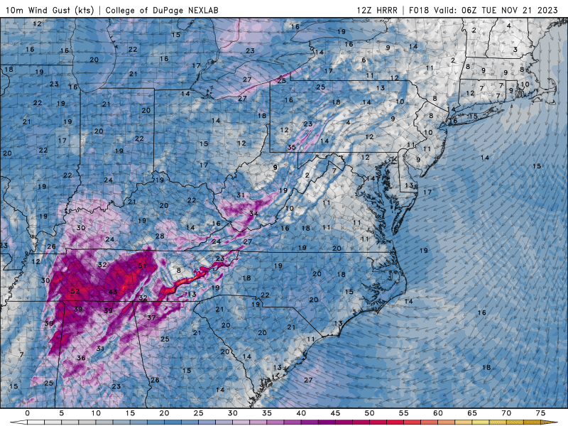 That's going to do it for today. Hold on to your hats, and especially consider any outdoor decorations you may have, as it'll be a breezy tonight into Tuesday. Don't forget to check out our video forecast below as well! We'll have a full Thanksgiving Day forecast in the days to come, but expectations are for a mild and dry day. Showers taper off overnight, leading to a mostly dry and seasonal weekend. Widespread showers and a healthy rain is increasingly likely early to mid next week. Rainfall amounts next week will generally vary between 0.75" to 1.25 inches, with locally higher amounts possible. View our video forecast below for more details. Pre-recorded for 5pm weather broadcast
Clouds increase today, as a few showers arrive Friday. We'll veer dry for the weekend, with much better and more widespread rainfall early to mid next week. Temperatures will hang around average Saturday through at least early next week. Pre-recorded for 5pm weather broadcast
Very low-end shower chances today, with generally cloudy skies above. Briefly drier air fills in for early Thursday, before a better shot at rainfall arrives Thursday night into Friday. We'll veer dry and cooler for the weekend, before a good shot at rainfall returns early to mid week (about 6-7 days out). This later system could be the one to pull us out of the intense drought we have been dealing with. Pre-recorded for 5pm weather broadcast
|