|
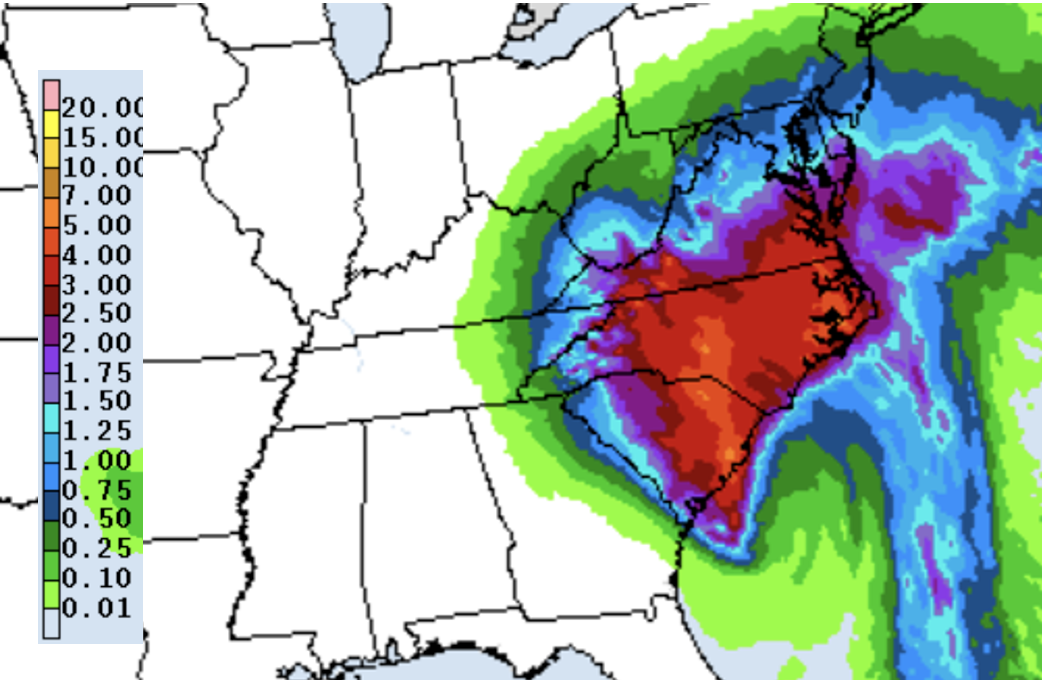
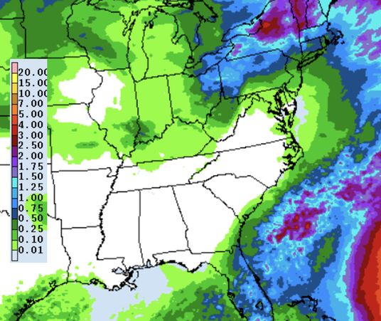
We have reverted back to below average rainfall, which is resulting in increasing signs of drought. If you recall from late Summer, West Tennessee was facing some severe drought in spots, but heavy rain in late July helped correct the issue. With dry conditions winning out as of late, abnormally dry conditions are once again expanding. Remnants of Ian will do no good to help, as any chances remain well east of the Plateau. This will be something to monitor moving forward, especially with dry conditions continuing through much of this week. Looking at the break down of Ian, an eastward shift as continued to win out. Because of this, showers have become more limited, with the best opportunity across northeast Tennessee. Across the valley, showers will be isolated to scattered, with less chances the further west you go. With that said, most will see cloud cover overnight tonight and through Saturday, before improving conditions arrive from west to east on Sunday. High pressure fills back in Monday, with gradually warming temperatures through mid week. Early week forecasts had 1-3" across East Tennessee, but as we mentioned, any eastward shift would lesson those amounts. As such, that is exactly what happened, where now little more than a few sprinkles are possible near the Plateau and up to 2" across the far northeastern tip of the state. A few lingering showers can't be ruled out by tomorrow evening, otherwise we'll be drying (or at least clearing) back out on Sunday. Saturday will be rather raw, with cloud cover, isolated to scattered showers, and winds 5-10 mph out of the north. Some gusts up to 15-20 mph can't be ruled out. Fortunately, things improve Sunday and into the new work week. Check out our video broadcast below for more, as well as following us on Twitter/Facebook. Pre-recorded for 5pm weather broadcast
0 Comments
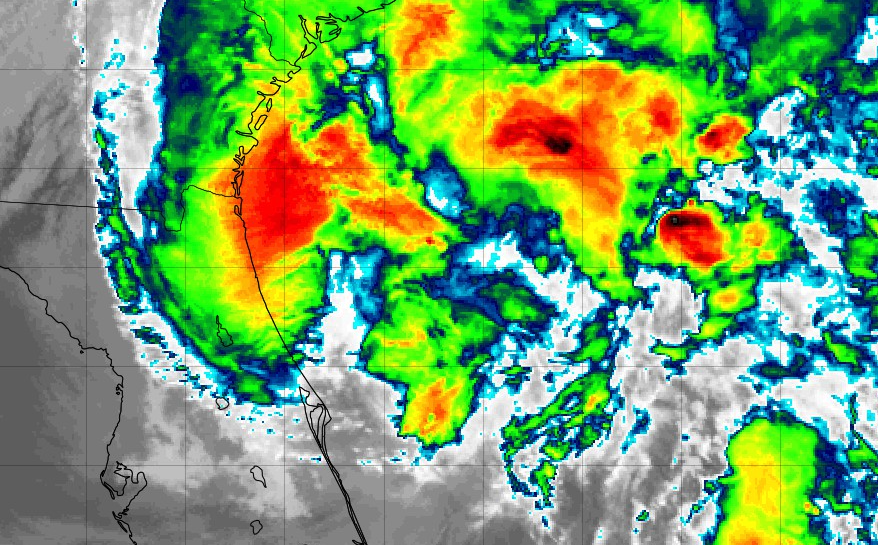
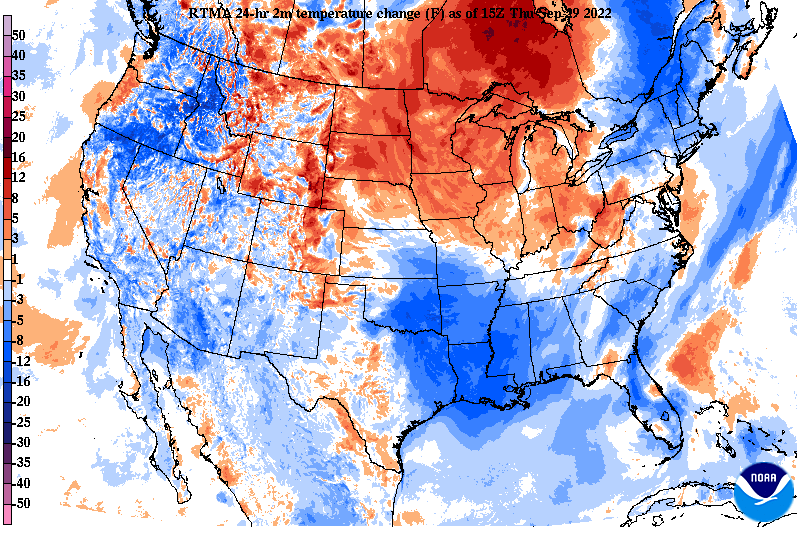
Howdy all! Another gorgeous day across the Volunteer State, with sunshine and temperatures in the mid 60s (1 pm). Over the next couple of hours, most valley locations will find the low 70s, before another cool night finds the area. Looking well south, this is what is left of Ian (now a tropical storm). Ian worked through much of the state of Florida last night and is now back into the Atlantic looking to target the East Coast. (continue reading for more information on its impacts locally) In terms of temperatures today, we are already seeing a trend of warmer conditions build in. As high pressure shifts east, warmer air is moving into the Midwest and Ohio Valley. Similar conditions are in for tomorrow, before remnants of Ian and its associated cloud cover bring cooler highs this weekend. In terms of Ian, the path has slightly shifted (good news). As we talked about yesterday, an eastward shift would result in lesser rainfall, and well, that's exactly what looks to happen. With the Appalachians in place (acting as a wall), dry descending air moves in, which results in lesser rainfall. With that said, northeast Tennessee will likely see periods of heavy rain as remnants of the system work across these locations. The good news still though is that this is over the course of a couple of days, so flash flooding/flooding potential is low here. Across the valley, scattered showers and cloudy skies will be the main result, with the best chances through the day Saturday. The further west you go, the less opportunity for rainfall you have. By early next week, drier conditions build back in as remnants of Ian shift east and out of the area. Remnants of Ian and its associated rainfall will be a good thing. We have been pretty dry the past couple of weeks, so rainfall is welcomed. This system should be out by midday Monday, with sunshine and near average temperatures returning toward mid week. Check out our video forecast below for more. Pre-recorded for 5pm weather broadcast
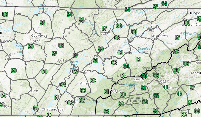
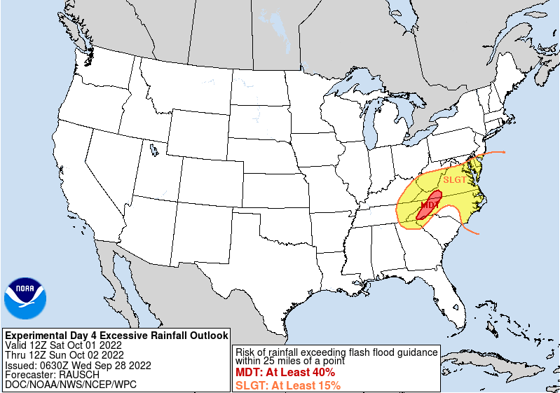
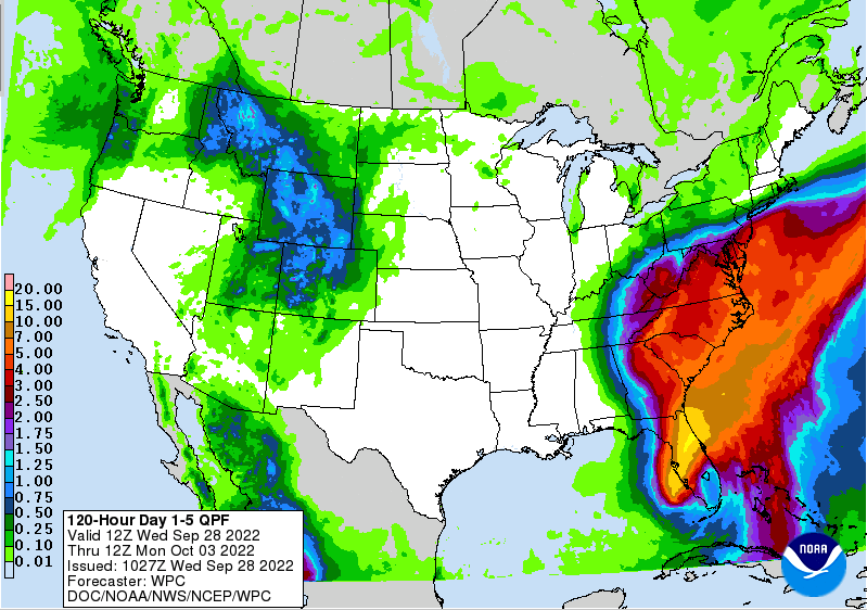
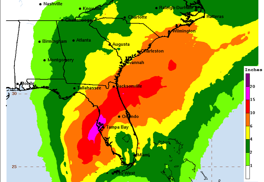
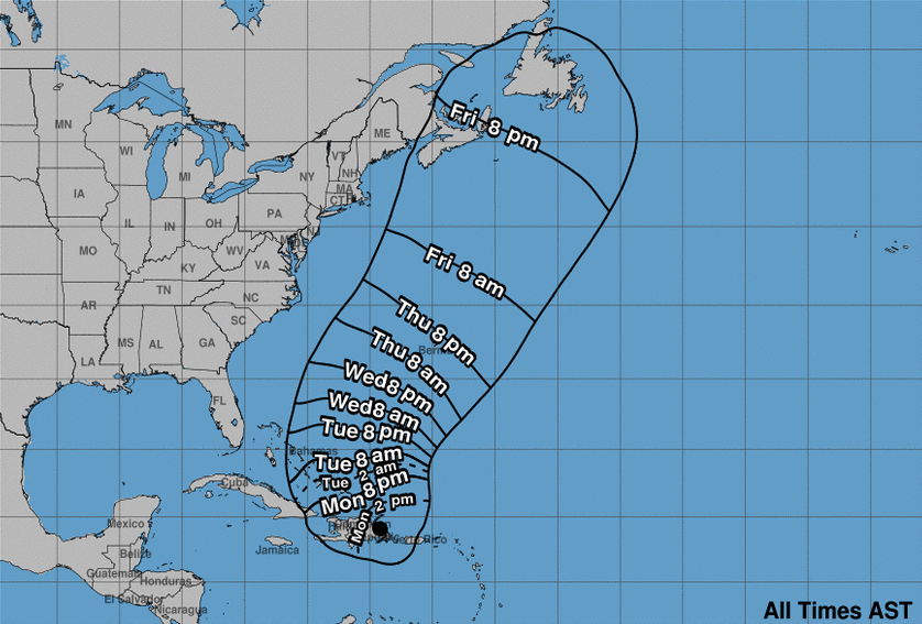
Check out noon time temperatures! Only in the upper 50s and low 60s, so you are in for a cool day. Highs are expected to top out in the mid and upper 60s today under mostly sunny skies. Moving forward, quiet and calm conditions stay in the forecast through most of Friday, before hurricane Ian works its way northward. Currently just a few miles off the Florida coast, Ian is expected to make landfall within the next half hour just south of Tampa. At a current category 4, Ian is on the brink of cat 5 strength, with current winds of 155 mph. Life threatening storm surge, tremendous rainfall, and winds over 150 mph should be expected. This system is anticipated to work northeast through Florida, wrapping into Georgia, and eventually through the East Coast states. Because of the heavy rainfall associated with the system, the Weather Prediction Center has highlighted a slight risk of flash flooding for all of East Tennessee Saturday morning through Sunday morning. There is still some question on exact path, but heavy rainfall is expected at times this weekend. Breaking this system down, Ian will make landfall near Tampa, working northeast across the state and then veering back westward into Georgia. Guidance varies on how far west the track of this system goes, but if this does track into the Tennessee Valley a bit sooner, this could mean lots of rainfall. Based on the data given, it seems fit that this will track just east of the Appalachians, before making its way into portions of Eastern Kentucky and into the Ohio Valley. Assuming this is true, northeast TN will more than likely see the heaviest rainfall Friday and through the weekend. Be alert and have a way to receive watches/warnings. The biggest risk will be with rainfall and the flash flooding/flooding associated. Though some gusty winds can't be ruled out, the rain is the big concern. Looking at rainfall amounts Friday and through the weekend, the East Coast could see up to 5 inches or more, while East Tennessee picks up between 1 and 3. Again, the exact path is not etched out yet, so any westward shift could lead to higher amounts, while an eastward pull would result in lesser totals. Stay tuned for further updates! Stay tuned for updates ahead. Changes are likely, which could bring variations in the current forecast. For now, 1-3" (from west to east) are expected with locally higher amounts possible. Enjoy the early Fall cool airmass, before remnants of Ian arrive late Friday and through the weekend. Pre-recorded for 5pm weather broadcast
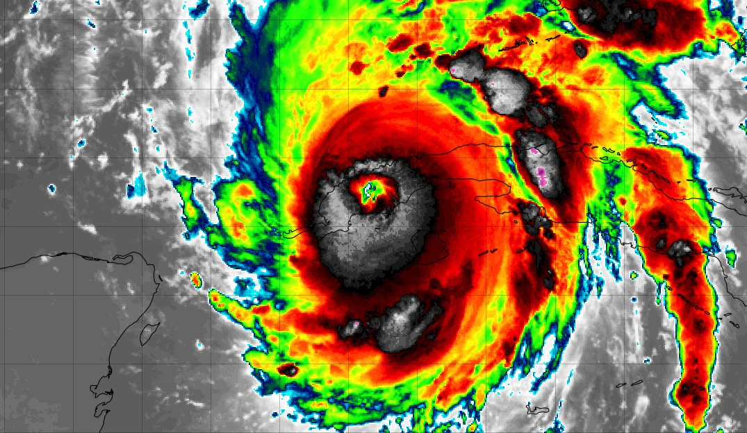
Good morning! Things are cool and quiet across East Tennessee this morning, with temperatures running in the mid 40s across the valley and upper 30s across the Plateau (7 am). Looking much further south, this is now major (cat 3) Hurricane Ian across Cuba. This storm is expected to continue its strength, eventually making landfall in Florida later in the week. How will this impact our neck of the woods? Well, as it makes landfall and works north, remnants of the storm will bring rainfall to much of the east (including us). Heavy rainfall and even some gusty winds can't be ruled out later Friday and into the weekend. Until then, anticipate quiet and cool conditions, with mostly sunny skies and highs in the 60s and 70s each day. In terms of rainfall amounts, of course Florida will see the heaviest. As Ian works north, it will weaken, though still bringing rainfall amounts between 1 and 2 inches to East Tennessee. The good news is this system should stay east of the Appalachians, helping to limit some of the heavier rainfall from making it into the area. Still can't rule out some flash flood potential, but it will come down to the exact path Ian takes, which (to a degree) is still up for debate. The slightest path change could make a big difference. That will do it for today. Certainly reach out to family members who may be in the path of this storm, particularly across Florida. Landfall looks to be late Wednesday and into the day Thursday as a major hurricane near the Tampa area. Pay attention to local announcements and news for those living on the West coast of Florida. We will see remnants by late work week and into the weekend, with some potential for flooding depending on the exact path and strength of the storm. Check back in for more details in the days to come. Pre-recorded for 5pm weather broadcast
Quit and cool the next few days, before remnants of current Hurricane Ian bring the potential for showers and storms Friday and the weekend. Check out our video forecast below for more: Good morning! Today marks the first official FULL day of the new Fall season, and man does it feel like it! Highs today will find the low to mid 70s under sunny skies. This continues into Saturday as well, before showers and a few storms return on Sunday. Check out our full video forecast below for more. Pre-recorded for 5pm weather broadcast
Cooler temperatures in the forecast Friday and Saturday, before our next wave brings showers and the chance for a few storms Sunday. Overall, this next system should be quick hitting, with another burst of cool air Monday and Tuesday. Check out more details below, as well as some potential Tropical impacts to the US next week. Pre-recorded for 5pm weather broadcast
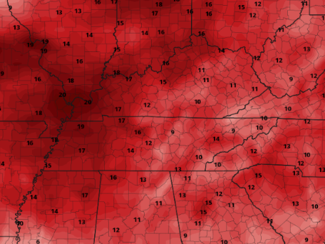
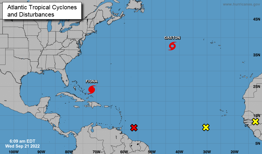
A warm one is on tap today, with highs well above average. Taking a look at expected highs versus the normal high this time of the year, the valley will be running around 10+ degrees above average. Further west, some locations could near the 20+ degree mark. Overall, its safe to say it'll be hot this afternoon, so keep your heat safety in mind! Looking ahead, we do have a very slight chance of showers tomorrow. A stout cold front will be dropping south through the day, increasing cloud cover and bringing a limited chance for rain. The further south the front drops, the less moisture will be associated. Because of that, the best rainfall locations are across the northern valley and plateau, though a few isolated showers can't be ruled out further south. Dry and cool conditions then return Thursday and Friday, with showers and storms not back in the forecast until later Sunday and into early next week. A big change in the Tropics, as Tropical Storm Gaston has now formed. Furthermore, a disturbance just north of South America is likely to form in the next 48 hours, so the Tropics are very activity right now. A couple of more disturbances off the coast of Africa may be something to monitor ahead as well. Check back in for more details in the days to come. As far as Fiona, she will work north and east, breaking through Bermuda as a potential major hurricane before drifting into the Central-north Atlantic. With that said, storm surge will be a concern along the East Coast, but no direct impacts are expected otherwise. That will round out the day, I hope everyone has a good one! Be sure to follow us on Twitter & Facebook for more updates. Pre-recorded for 5pm weather broadcast
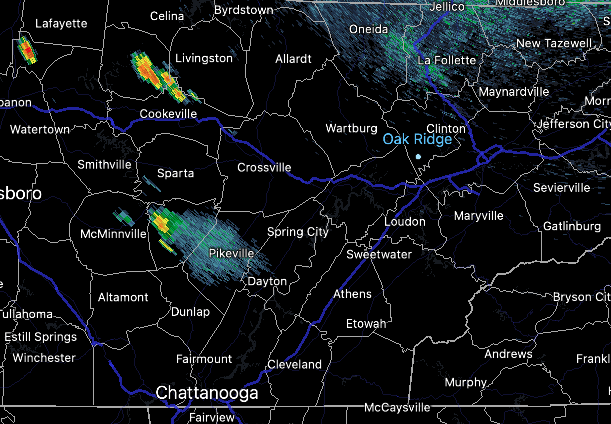
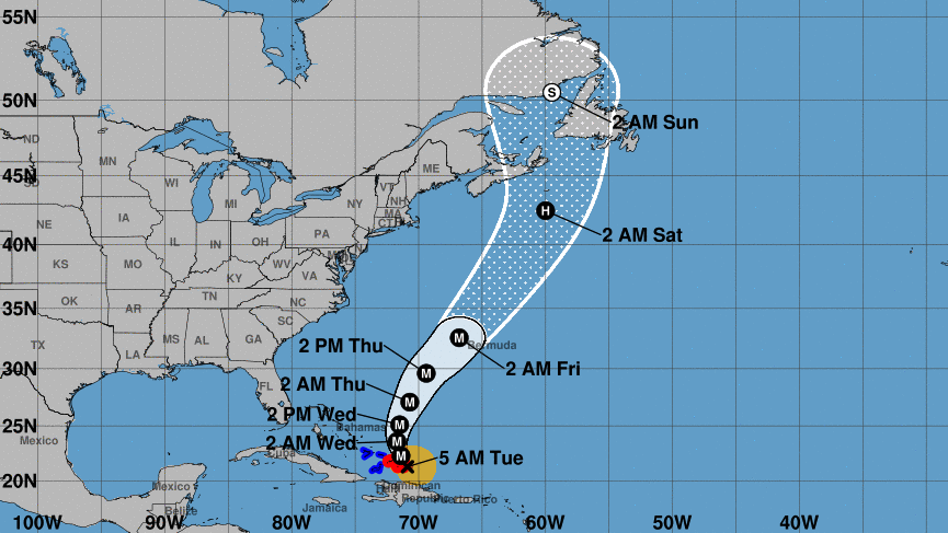
Good morning! A cold front sitting to our north has actually allowed for a few (now) dying showers across the Plateau and Middle Tennessee. Not expecting much in the way of rainfall chances for the great majority of us, but for those in the higher elevations to the west, you may see a shower the next couple of hours. In terms of the rest of the day, mostly sunny with highs topping out around 90 degrees. Even warmer temps find us tomorrow, before a cold front cools things off late work week. The latest on Hurricane Fiona shows her sitting just north of the Dominican Republic after running through Puerto Rico, eventually crossing the Bahamas, and then working toward Bermuda. Unfortunately, this looks to remain a major hurricane (category 3 or higher) for the next several days, which could wreak havoc on Bermuda and the Caribbean islands. No major issues are scheduled to the Continental USA. Other than warming temperatures through tomorrow, and then a cold front Thursday, things stay quiet and mostly dry through the end of the work week. A cold front does arrive late weekend and into early next week, bringing our next bout of real rainfall. Early predictions look to be between half an inch to an inch with locally higher amounts possible in thunderstorms. Take a look at our video broadcast below for more details. Pre-recorded for 5pm weather broadcast
Good afternoon! Cloud cover is beginning to increase from our north to south this afternoon, as a frontal boundary sits across the Ohio River Valley. Other than a mix of sunshine and cloud cover, we will stay dry with highs near 90 degrees. Looking at the Tropics, Hurricane Fiona is blazing through portions of the Caribbean. She will bend north and eastward in the days to come, potentially running through Bermuda on her way. Time will tell, but for now no direct impacts are expected across the USA in the days to come. The one exception is some storm surge along the coast, but otherwise, fairly quiet. In terms of rainfall chances over the next week, they look limited. In the next 5 days alone, very little to no rainfall should be expected. Towards next week, we have a good shot, but timing it out and on exactly how much rainfall is a bit too early. For now the timeframe looks to be Monday and Tuesday. Temperatures will generally trend warmer through midweek, before cooling with a passing cold front Thursday. Highs will then return to the 70s and 80s Thursday, Friday, and the weekend. Pre-recorded for 5pm weather broadcast
|
Your trusted source for everything weather in East Tennessee.
Social Media
|


