|
Good afternoon! It has been pretty quiet so far but showers are quickly on their way. In fact a few are already brushing through the Central Valley for the lunch time hour. As for the severe outlook, we are under a Marginal risk. This doesn't look the most favorable, but a few strong storm could produce strong winds, small hail, and localized heavy rainfall. This will primarily be this afternoon and evening before showers begin tapering off overnight and into Saturday. 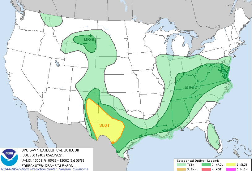 Along with the system is a stout cold front. This front will pivot eastward, bringing temperatures 15-20+ cooler over the next 24 hours with highs tomorrow to be in the mid 60s. For those of you hitting the lake, it may be a bit chilly tomorrow but temperatures will warm through the Holiday weekend with highs Monday in the low to mid 80s.  Shower chances will continue to increase this afternoon as the front draws closer. The bulk of activity will be now through the evening. By Saturday morning, much of the area will begin drying out with a few lingering showers possible along the Smokies. By the afternoon, much of the area should return to partly cloudy skies. Full sunshine will be in store for much of Sunday and Memorial Day.  If you don't follow us on Twitter/Facebook, or in case you missed it, here's the latest drought map for the state of Tennessee. As anticipated, a couple of below average precipitation weeks have created some abnormally dry conditions across parts of the state. The added rainfall today and the normal to slightly above normal outlook from the CPC should keep things at bay in the near-future. 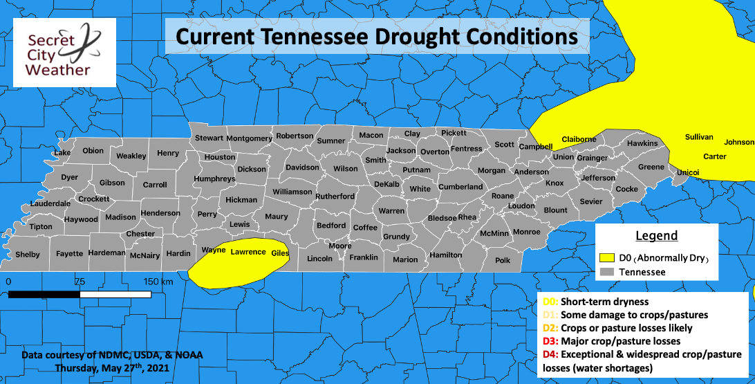 That will wrap it up for today...we will be off (from posting) Monday but will continue to keep you up to date as always via Twitter/Facebook. Have a great Memorial Day and associated weekend and stay up to date for the latest as a few strong showers/storms are possible this afternoon & evening. Pre-recorded for 5pm show
0 Comments
Cumulus clouds continue to develop ahead of the front this afternoon. As you can make out from satellite, this line of showers/storms is working eastward. Fortunately for us, it looks a bit more "scary" than actuality. With drier air across East Tennessee and dying instability eastward, most of us will stay on the dry side with only an isolated shower/storm or two possible. Highs today continue to be warm as well, topping out in the upper 80s. 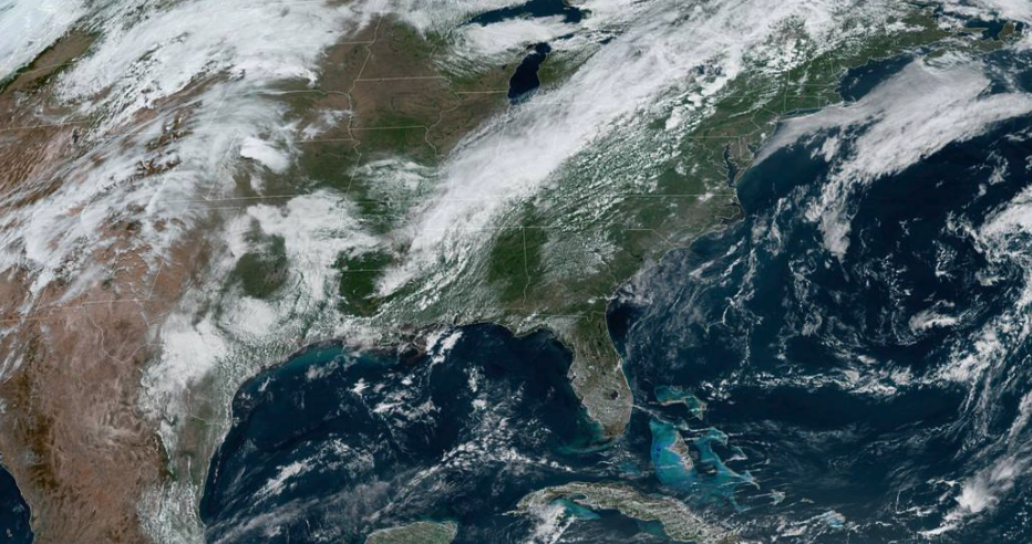 Comparing satellite to the SPC outlook today, the cold front will primarily impact Eastern Kentucky and north. Again, a few isolated showers and storms could be possible late this afternoon and evening, but activity should be fairly minimal. This map also points out the moderate risk across the Central Plains. This is associated with a strengthening low that will shift eastward in the coming days. Though severe weather looks Marginal (for now) on Friday, a few strong to severe storms will be possible with this system. 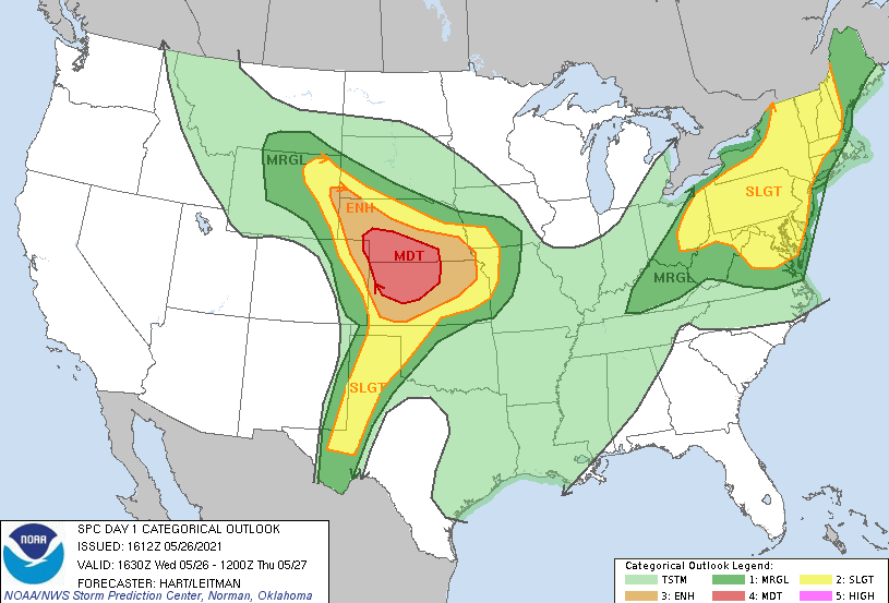 Model guidance does a fair job at representing the isolated afternoon showers/storms today and tomorrow. By Friday that system (just discussed above) will work to our north bringing moderate to strong showers and storms at times during the day. The main threats will be strong winds, small hail, and localized heavy rainfall. Following this system, we begin to dry back out for Sunday and Memorial Day.  Conditions remain on the warm side but a break is in site. With a front arriving tonight, temperatures will dial down a couple of degrees before our next system lowers temperatures into the 70s for the weekend. Pre-recorded for 5pm show
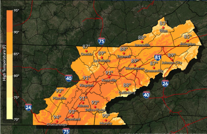
Good morning! As the ridge of the high we've been dealing with shifts south and east, highs will be at their peak today. Our average is 80 to 81 degrees and most locations will find highs right around 90 to the lower 90s. We will be close, but I think we will make it by without beating the record of 93 degrees set back in 2011. Looking below, even with warm temperatures the past several days we are still warming compared to this time yesterday.  As mentioned, forecasted highs will be near 90 for most of East Tennessee with the southern valley likely finding the lower 90s this afternoon. Depending on how much cloud cover we see later today could impact afternoon highs. Given the trend, I am comfortable saying 90 is likely for most. 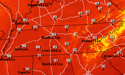 Working ahead, showers begin making an appearance. A low moving through Canada will bring a cold front across the region Thursday. This will be weak and only bring isolated to scattered showers. This will be followed by a stronger low moving across the Ohio Valley and Great Lakes region bringing moderate to heavy showers and thunderstorms for Friday. This will mainly be an afternoon to evening event, but a few showers will linger into the weekend as well. Overall, this will help knock temperatures back to near average with highs Saturday to be in the mid to upper 70s.  A mix of cloud cover and sunshine will again be the story today with highs very warm. Continue to practice heat safety will drinking plenty of water and taking breaks throughout the day. Have a good one and stay cool! Pre-recorded for 5pm show
We start the new work week very mild this morning. Temperatures across the board range from the upper 50s to low 60s with mostly sunny skies. Looking over the Smokies we see the last of the fog lifting out as a beautiful morning is in store to enjoy a walk before it gets too hot. Afternoon highs today will top out in the upper 80s and lower 90s. 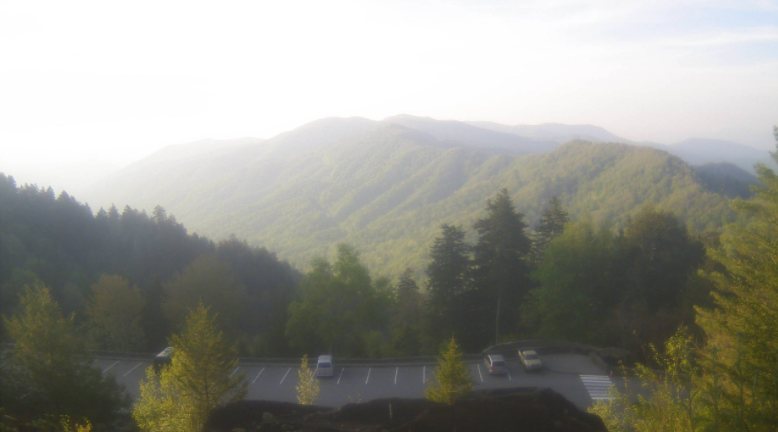 With high pressure locking in the dry air and warm temperatures the past several days, that begins breaking down early this week. As the high shifts southward, a few isolated showers will find the lee-ward side of the Smokies this afternoon and the days ahead. For the remainder of us, anticipate staying dry with temperatures ranging into the lower 90s through Wednesday. By Thursday, better rain chances arrive as a system to the north and west nears in. Isolated showers/storms are possible Thursday afternoon before becoming more widespread on Friday.  If you recall this graphic from last week, East Tennessee had no expected rainfall over the next 7 days. This week is a bit of a different story. Looking at the 1-5 rainfall forecast, a rainfall total of an inch is anticipated by the weekend. This isn't an impressive amount, and is still below average, but we'll take it as drought conditions could begin creeping in. The good news is the CPC suggests above average rainfall for the end of may and beginning of June. 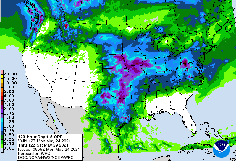 With well above average temperatures expected, make sure to throw on the sunscreen, take breaks, and stay well hydrated. Our hottest day of the week will be tomorrow with most locations in the low to mid 90s. Pre-recorded for 5pm show
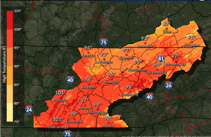
Good morning! Like a broken record, it will be another warm and mostly sunny day with highs in the upper 80s. As high pressure continues to settle in across the Tennessee Valley, we will remain warming and dry. There is some light at the end of the tunnel (if you are sick of the unseasonably warm temperatures and dry conditions), as rain chances move back in midweek next week.  Looking at the NWS official forecast (LEFT), highs through the weekend will range from the upper 80s to lower 90s. Looking at the image on the right, this is the WORST-CASE scenario. Because statistics plays a large role in weather forecasts, this image indicates the 90th percentile of values. Though we likely won't see mid to upper 90s, things will still be very warm for this time of the year. Be sure to throw on that sunscreen and drink lots of water if you're outside for lengthy amounts of time.
With high pressure in place, quiet weather remains for the time being. As the high breaks down and shifts south early next week, showers rounding the ridge will begin to work back in. A cold front extended down from Canada will also assist in bringing better shower chances Wednesday and Thursday, as well as cooler temperatures back down to near average. Until then, anticipate things to continue warming and staying dry.  That will conclude todays forecast, don't forget to share your images with us by sending them to [email protected] or tagging us on Twitter/Facebook. Have an excellent weekend, enjoy the sunshine, and stay cool! Pre-recorded for 5pm show
Good morning! Lows last night into this morning were very mild (upper 50s and lows 60s). That "above average" trend continues today with highs to top out in the mid 80s. Some locations across the southern valley and in urban areas could find highs in the upper 80s before the day is over with. Looking below, you can see how warm things are across much of the eastern two-thirds of the nation. This looks to continue for quite sometime as a "blocking-high" is across the Carolinas. 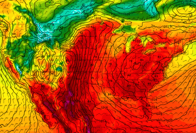 With high pressure in place, we stay mostly dry the next 7 days. With a low across the desert and a high in the Carolinas, the flow of these two pressure gradients will force lots of moisture across the Central USA. We could see a few isolated showers as the high breaks down early to mid next week, but until then, things stay hot and mostly dry. We continue to highlight the likelihood for drought conditions to creep in by next week, so we'll keep you posted. 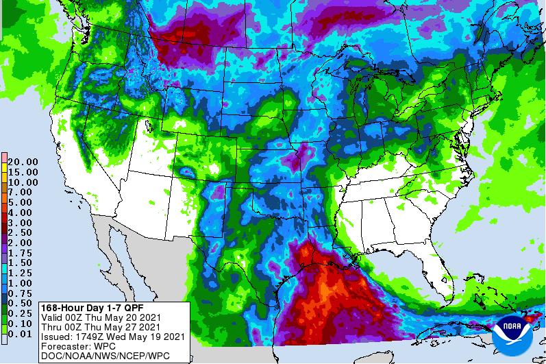 For now, beat the heat. Especially those outdoors for extended periods of time, take breaks, hydrate, and stay cool. Temperatures will average 10-15 degrees above average through the next 5+ days, so take the proper precautions. Pre-recorded for 5pm show
Good afternoon! Thin cloud cover continues to linger across East Tennessee as a system to the west works northward. The good news is high pressure continues to settle in to the east, allowing for clearing Thursday and onward. For today, partly cloudy skies will continue with highs topping out in the lower 80s. 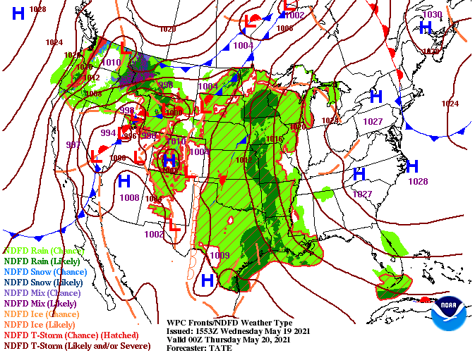 With the high settling across the Appalachians, temperatures will warm up the next several days. As discussed earlier in the week, the clockwise flow of the high will pull in summer-like heat from the Gulf and south. Highs Friday will range in the upper 80s with lower 90s likely through the weekend. Our average high is 80 for Knoxville so most will be 10+ degrees above that by the start of the weekend. This will be a great time to finally get out and enjoy the start of "lake season". 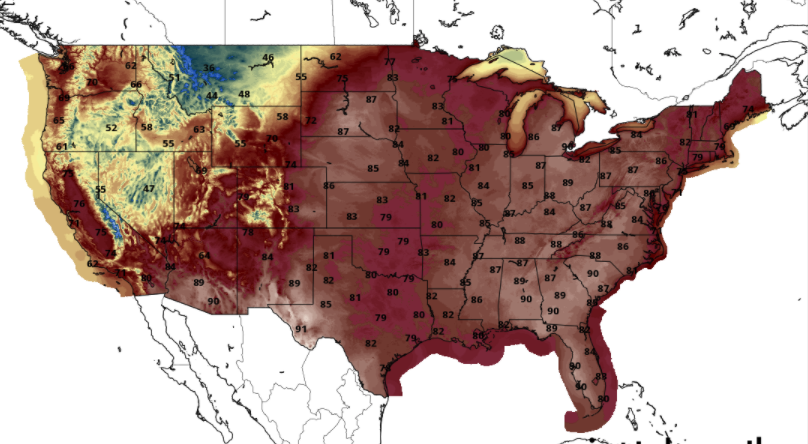 Working ahead, a heat wave will be accompanied with dry conditions. High pressure will lock in warm and dry weather through the remainder of the week with showers out of the discussion through at least early next week. Increased precipitation will be likely across the Central US, but the eastern half will stay mostly dry. Drought conditions, especially as the growing season takes off, will be a concern moving forward.  That will do it for today....don't forget to check out our daily video forecast below. Warmer days are coming! Pre-recorded for 5pm show
Good afternoon! Another mild one (temperature-wise) today with highs to be around 80 degrees. This is generally our average for this time of the year, so enjoy it while it lasts. Looking at the future surface map, high pressure will build in just to the east. Because areas of high pressure spin clockwise, the return flow (or the flow on the left side of the high) will pull in warm southerly air. This will increase our temperatures as well as keep sunshine locked in place Wednesday and onward. 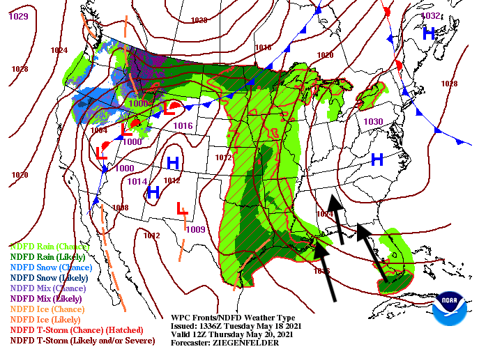 A quick look ahead shows highs Friday and through the weekend around 90 for some areas of East Tennessee. In fact, I wouldn't be surprised to find Chattanooga and the lower Tennessee Valley in the lower 90's throughout the weekend. This isn't record-beating or extremely uncommon to get a big warm-up in late May. For reference, the record for May 22nd is 96 degrees and we are expecting highs around 90, so plenty of wiggle room.  Though we have seen little if any shower/sprinkle activity today, that nuisance will continue through the afternoon and early evening tonight. As high pressure builds in from the north and east, skies will clear throughout the night and into Wednesday, with lots of sunshine the remainder of the work week. A few clouds will be possible at times, but again, the biggest threat will be the heat. We will progressively get warmer Wednesday through Saturday. I will add the threat of drought is on the rise. Because we have picked up little rainfall the past several days and don't anticipate to through the remainder of the week, drought conditions could begin spawning up across the state. We will keep a close eye on this ahead and give you the latest on how this might impact our region.  With well above average temperatures in the forecast, be sure to keep your heat safety in mind. Thankfully, it won't be as humid as your typical summer-time heat, but still will be uncomfortable for some. Drink lots of water, take breaks, and find a way to get cool if you plan to be outside for extended periods of time (especially this weekend). Pre-recorded for 5pm show
I hope everyone had a good weekend! As we jump into the new week, a system to our southwest and a front across the region will allow for a few isolated showers this afternoon and again for Tuesday. Looking at satellite, dense cloud cover, associated with a strong low, resides over Texas this afternoon and will bring strong to severe storms across that area of the US.  Looking ahead, isolated showers and a few storms could be possible both this afternoon and again tomorrow. In behind the front and low to the southwest will be dominating high pressure. This will shift eastward, arriving by midweek. With the high in place the second half of the week, lots of sunshine and warm temperatures are in store. 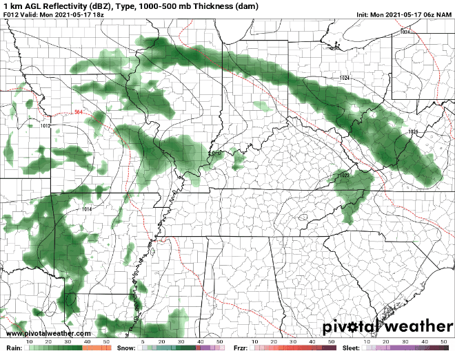 Looking at the next 6-10 days, well above average temperatures are expected from the Central Plains and east. This can be contributed to the high that will be positioned right above the area. To the west, higher rainfall totals are likely (Central Plains/Upper Midwest) given the return flow of the high. Across our area, anticipate much drier and warmer conditions Wednesday through at least early next week. Highs for some could be around 90 degrees as early as Thursday afternoon and lower 90s by the end of the weekend. 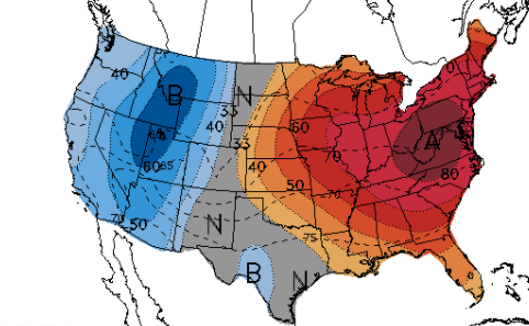 Cloud cover and a few isolated showers will make temperatures feel right around the average for this time of the year but big changes are ahead. Highs near 90 will find East Tennessee the second half of the work week with plentiful sunshine to also accompany. Pre-recorded for 5pm show
A picture perfect Friday morning across East Tennessee with lots of sunshine and temperatures a bit closer to what is expected this time of the year. Looking below, most locations don't even have a cloud in the sky late this morning. Highs for most valley locations will top out in the mid 70s with a warming trend expected to continue into the weekend. 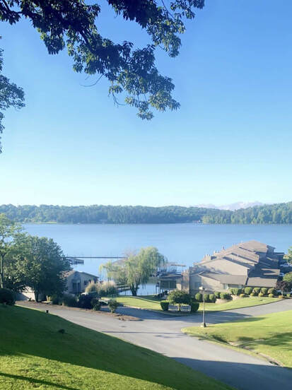 Courtesy of Ashley Howe along the Tennessee River in Chattanooga Speaking of a warming trend, the CPC suggests at to slightly above average temperatures through the end of May for our neck of the woods. The overall pattern across the US has been slow this year. We are still in a early Spring phase, but we are slowly transitioning to something a bit more common for this time of the year. As a result, anticipate temperatures to warm through early next week and stay relatively idle (near average) through the end of the month. On the flip side, as the pattern evolves, precipitation is expected to be lower than average through the end of the month. This could result in heightened drought concerns, but with the above average rain we've seen so far this year, we'll be just fine for now.  Looking ahead, high pressure will settle just to our east allowing for ample sunshine today and into tomorrow. A low to the west will bring the potential for isolated showers/storms Sunday afternoon and through next week. With this though, they will be limited. The bulk of rainfall will be across the Bluegrass of Kentucky and into the Central Plains (more info in our daily video forecast below).  That will wrap it up for today. Similar conditions are in the forecast for Saturday before areas of cloud cover and isolated showers/storms return Sunday and early next week. For a full outlook, visit the "Weekly Forecast" tab for more information. Pre-recorded for 5pm show
|