|
Happy Thanksgiving-Eve to everyone! If you are traveling today, please be weather aware. Looking below is today's NWS (National Weather Service) active alerts map showing LOTS of watches, warnings, advisories, and statements throughout the USA. This "mess" to the west will continue moving east, bringing another round of cool temps and showers this weekend and early next week. 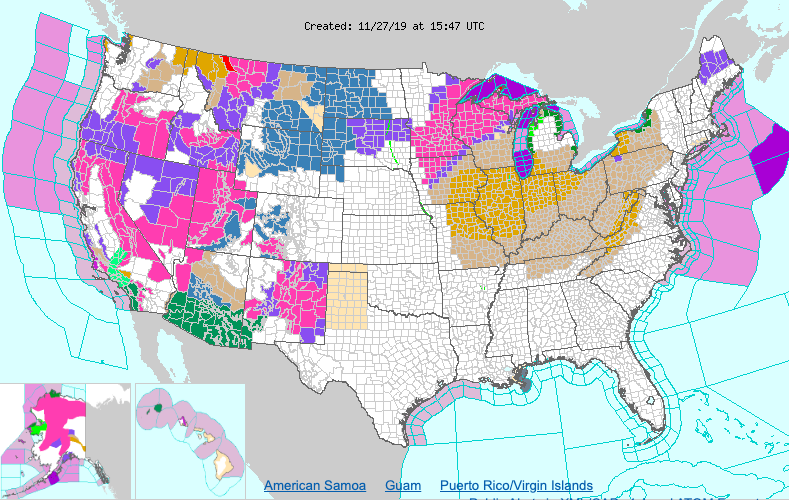 Getting into the surface map, a cold front is currently working through providing clearer skies and a bit of a reprieve from showers. Into tonight, skies will clear out giving us low's in the mid 30's. For Thanksgiving, pleasant, with dry and cool conditions for the day. 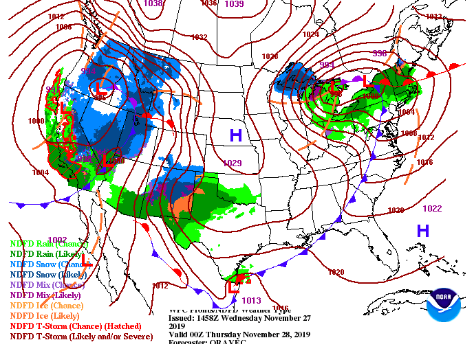 Model guidance shows Thanksgiving staying dry but cloud cover will build through the later part of the day. A cloudy Friday could give way to an isolated shower in the afternoon, otherwise showers will hold off until Saturday. Saturday afternoon and Sunday showers will fall before becoming more scattered Sunday afternoon. Model guidance is suggesting the possibility of some wintry precipitation into early next week as we may get some wrap around moisture. This wintry precipitation will stay in the higher elevations, but cold temps will be around for all. Anticipate high's in the 40's to begin the new work week with sunny skies return by Tuesday.  Here is your Thanksgiving outlook: Sunny and cool to start with clouds increasing through the day ahead of our next rain maker. High's staying cool in the low 50's. 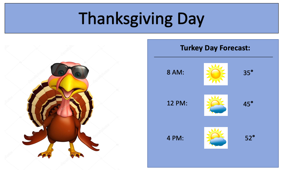 That will do it for your Wednesday forecast, but have a FANTASTIC Thanksgiving! We will continue keeping you up to date on Twitter and Facebook, but we will be off the air and website tomorrow and Friday. Have a good one!
0 Comments
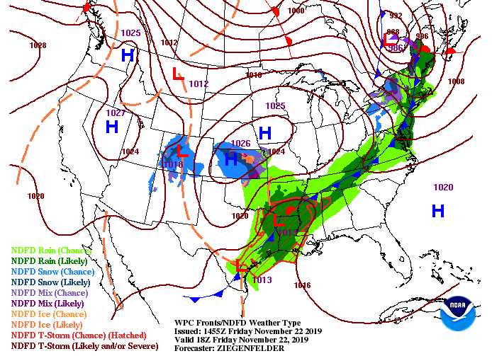
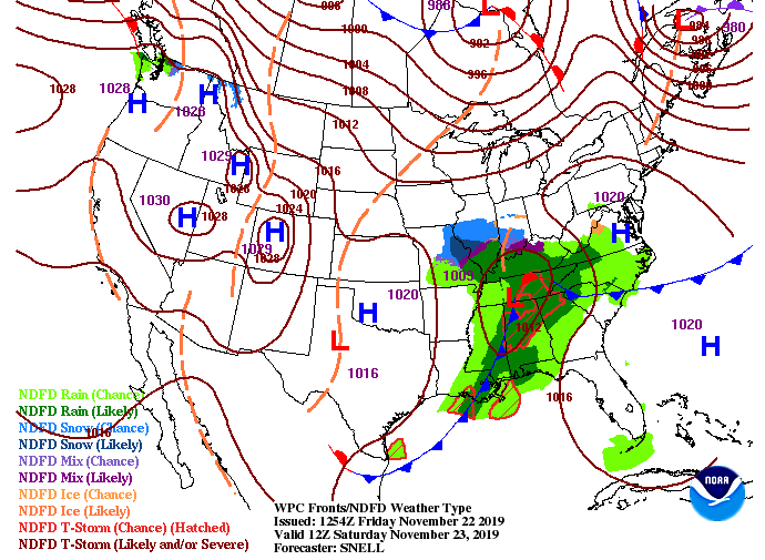
Happy Tuesday to all! We are one day closer to filling our faces with lots of food, but until then, we first must face a strong system currently to the west. The lasts SPC (Storm Prediction Center) outlook shows an enhanced region in parts of West TN, West KY, Arkansas, and Missouri. The good news for us is this system will be moving in a northeast direction (avoiding much of the heavier storms here at home). 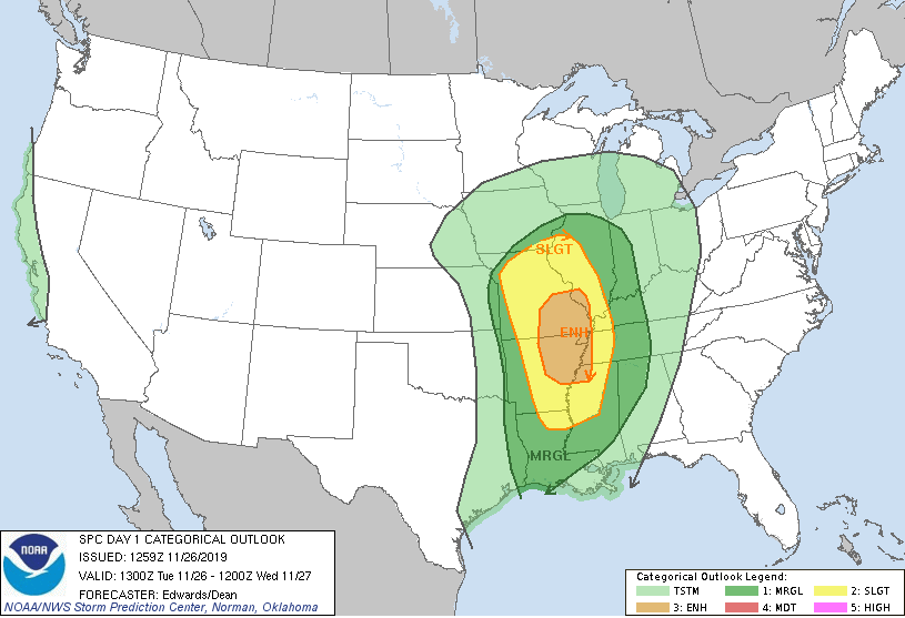 The surface map below shows the set up of this system with heavy snow storms to the north and severe storms to the south. East TN will feel a brief glimpse of these storms will gusty winds (30+ mph) overnight and into Wednesday, as well as heavier rains and some thunder. Fortunately for us, this system will move out just in time for Thanksgiving with sunnier skies and cooler temperatures in the forecast. 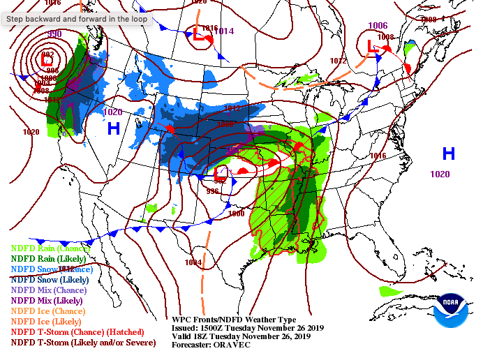 System #1: Looking ahead at the set up of these two next systems, showers will arrive this evening (starting scattered) and becoming more moderate & heavy late overnight. Showers will begin moving out by the lunch time hour tomorrow as a cold front sweeps through. High's will arrive early in the day tomorrow (low/mid 60's) with temperatures eventually falling by tomorrow afternoon. The cold front will not only decrease temperatures but also help clear the skies. Thanksgiving: Thursday will be beautiful with sunny skies and a mix of light clouds through the day. Temperatures will feel very much like Fall as well, in the low 50's as high's. By Thursday night, clouds will be reintroduced, increasing overnight and through the day Friday. Weekend (System #2): By Saturday, showers will arrive (mainly in the afternoon hours) and carry through the first half of the day Sunday. The latest data suggests this next round won't be as strong, with more light to moderate shower activity. With the second system moving out late Sunday, temperatures will again fall, leaving high's back in the 40's early next week. 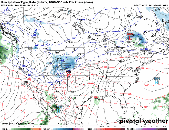 The latest outlook below suggests rainfall between half an inch and an inch over the next 5 days. Keep in mind this is just one of several models. As for the system tonight and into tomorrow, total rainfall is expected to be around half an inch with localized amounts higher in heavier storms. 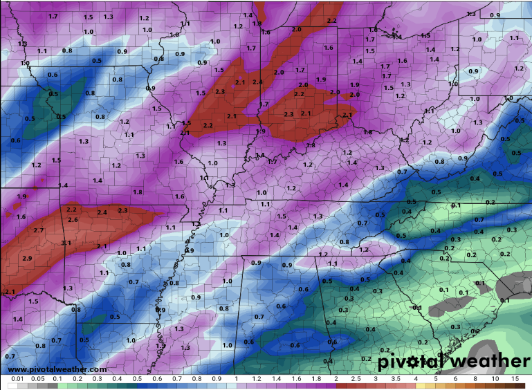 That will conclude today's forecast so stay up to date on our social media for the latest in these next systems. Have a good one! Happy Monday to all! A beautiful day is in store today with sunny skies and temperatures in the upper 50's. Satellite is still picking up on some patchy fog from this morning, but it is quickly dissipating as we get into the afternoon hours.  Looking at the current surface map, it may seem pretty boring but a VERY active period is on the way. For now, a high pressure system sits overhead allowing for the sunny skies today and first half of the day Tuesday. A winter storm (for the upper mid west and moderate to heavy showers for the south) will arrive tomorrow night and Wednesday. This will be round 1 of two systems that will be felt this week. The good news out of this is Thanksgiving will be mostly dry for us here in east TN. 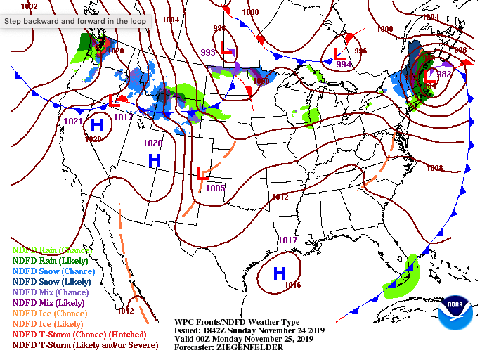 Looking at model guidance and the suggested setup/movement of these systems, we see the first of two rainmakers arriving tomorrow night. Gusty winds are likely to our north and west with gusts up to 25mph here in east TN for the day Wednesday. A cold front will force rain out Wednesday afternoon, leaving cooler temperatures Thanksgiving day in the low 50's. We will stay mostly dry (an isolated shower possible in the PM hours) on Thanksgiving. Friday, the next system begins to draw near bringing scattered showers by the afternoon and overnight hours with the bulk arriving Saturday.  With this being a high travel period, be sure to stay up to date on the weather. For those in east TN or coming to the area, Thanksgiving Day will be pleasant but the days leading and following will be quite wet (even snowy depending where family/friends are coming from) so be careful. As always though, we will keep you updated on the latest! If you have some spare time and wouldn't mind (1-3 minutes), click the link below and provide Secret City Weather some feedback. Without our viewers we wouldn't be where we are so your feedback is vital. That will wrap up Mondays forecast but check back in through the week as two massive systems are planned to sweep through much of the USA. The latest scan from radar shows showers continuing to move in from the west this afternoon. As we get into the evening hours, showers will become more isolated. Unfortunately, another day of soggy conditions returns to start the weekend. High's this afternoon will feel a bit cooler with the cloud cover in the mid 50's.  Todays surface map (left) shows the parent low to the southwest. As we work into Saturday the system will move to the northeast (right). With this movement over the area, reinforcing moisture from the Gulf will funnel into the region providing rainfall through much of Saturday, eventually pushing out late overnight Saturday and into Sunday.
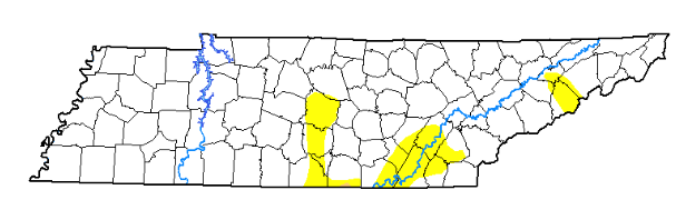
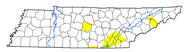
Model guidance continues to suggest shower coverage thinning out this evening before showers are reintroduced tomorrow. By tomorrow night, much of this system will have moved off to the east setting us up with a sunny and cooler Sunday. By the start of the new work week, temperatures will be back into the upper 50's with sunny skies sticking around. 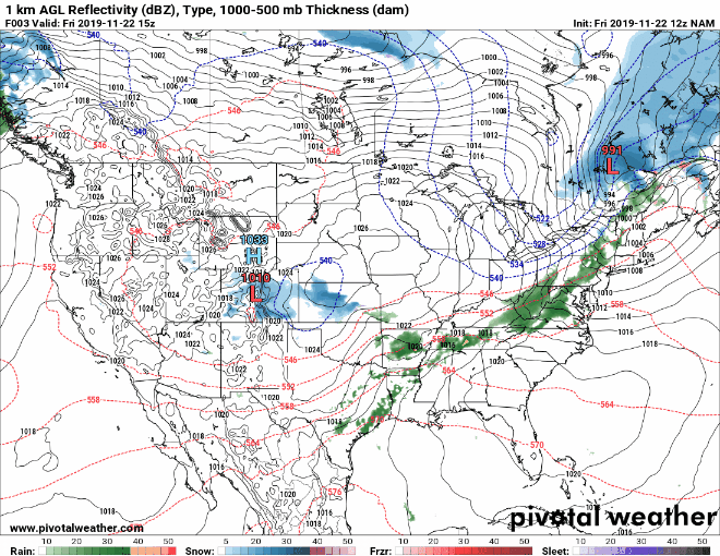 If you plan to get out of the house tomorrow, remember those umbrellas as we will have showers on and off through the day. Sunday is your best day for any outdoor errands, clearer skies returning with warmer temps in the days to follow. Have a great end to your Friday and a good weekend! Good afternoon! There has been little change in the latest drought map, but this will quickly change as rain is on its way. With an inch or more of rain expected throughout east TN, we will be back to normal conditions in the very near future. For this afternoon, we will stay mild with temperatures in the lower 60's and cloud cover increasing.
Speaking of that rain, model guidance suggests scattered showers will arrive late overnight tonight before transitioning to more steady showers Friday. By the end of the day tomorrow, they will become more scattered. Getting into the day Saturday, reinforcing moisture from the south will provide additional rainfall before the rain moves out the later half of the day. Clear skies and cooler temperatures return Sunday afternoon with warmer temps to start the new work week next week.  Umbrellas will be needed tomorrow so don't forget them on your way out the door! Have a good rest of your Thursday. We started the morning on the cloudy side but have quickly cleared out. Sunny skies and warmer temperatures have returned and will stick around Thursday, as well. We will have high's this afternoon in the upper 50's with lower 60's expected tomorrow. If you look below at the latest from the National Hurricane Center, we still have an active tropics. Keep in mind, hurricane season does officially run through the end of this month, so it is not surprising to see a tropical storm (Sebastien) form in the Atlantic. There is not threat to the US as this storm will continue moving north and east. 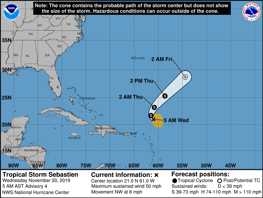 Getting back to today and tomorrow, we will stay sunny and dry with comfortable conditions. As we get into tomorrow evening, clouds will move in ahead of a system currently sitting to the south and west. This will stick around through Friday and the first half of the day Saturday before moving out. 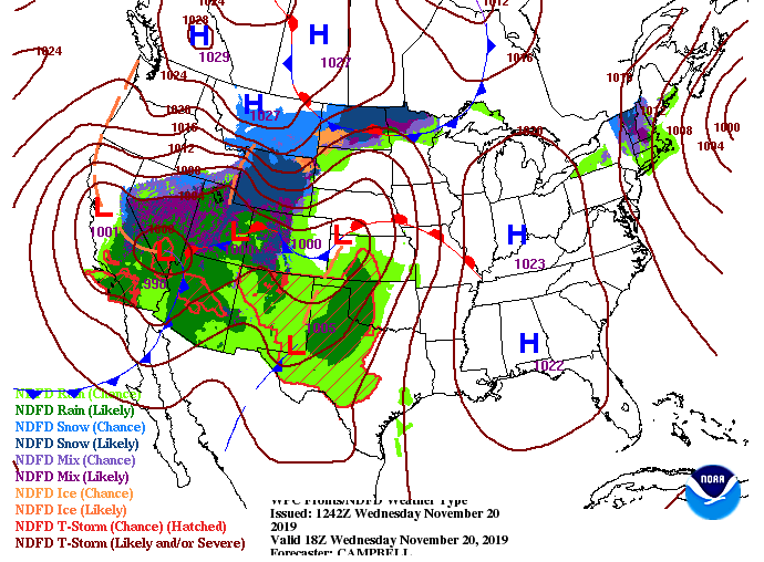 Model guidance shows isolated showers moving in overnight Thursday, with the bulk of the system arriving by Friday. Showers will be light to moderate through the day Friday and Saturday with total rainfall expected to be over an inch. Clearer skies and cooler temperatures will return for the day Sunday, with warming temperatures as we get into next week.  That'll do it for Wednesday, but be sure to go out and enjoy these sunny skies and warmer temperatures if you can! Cloud cover continues to stick around across east Tennessee thanks to a system hanging to our north. The good news is, this will be short lived as clearing will take place overnight and into Wednesday morning. Sunny skies will quickly return for your Wednesday and we will rebound temperatures back near 60 degrees.  Model guidance is continuing to suggest light showers moving into the area this afternoon. Much of the activity will stay north and east of the valley but a stray shower or two can't be ruled out (20% chance). Working into tonight, clouds will begin moving out as a high moves in from the west.  The surface map shows the weak shower activity associated with a system to the north. The bigger activity we are eyeing is to the west (Southwest to be exact). We are anticipating a wet end to the work week and beginning to the weekend. First, though, we will have a high pressure system sit overhead Wednesday and much of Thursday before that next system arrives. 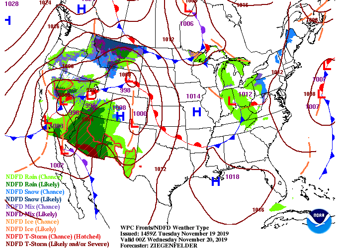 We will keep you updated via social media on any showers that develop this afternoon. Nonetheless, they will be light and very quick as sunny skies and temps near 60 return tomorrow. Happy Monday to all! Average temperatures this time of the year is 60 degrees and we will be nearing that this afternoon with high's in the mid to upper 50's. Cloud cover has moved out as well but it will soon return this evening and overnight, as you can see from the west.  This cloud cover is all associated with a system to the north and west that will move through overnight and into Tuesday. Light shower activity can't be ruled out for northern areas of Tennessee and into Kentucky. As for the valley, we will stay mostly dry tomorrow afternoon with broken cloud cover throughout much of the day. Working into Wednesday, sunny skies and warmer temperatures will return. 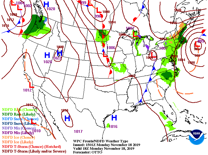 Jumping into model guidance, the NAM is suggesting shower activity will stay more northern tomorrow afternoon but some of the high-res models suggest a brief shower in the northern valley as well. Fortunately, working into Wednesday, a high pressure system will work in bringing back sunny skies and high's around 60 degrees. Toward the end of the gif below, shower activity increases to close out the work week.  If you live in eastern Kentucky or northern Tennessee it wouldn't hurt to bring an umbrella incase you run into a shower toward the end of the work day. This system will be quick moving, just grazing east TN before sunny skies return mid week. We will finally be ending the week on a warmer note with high's this afternoon in the lower 50's. Cloud cover will continue moving out as the system to our east moves north. Taking an extended outlook into the end of November, the Climate Prediction Center suggests slightly cooler than average temperatures (low to mid 50's range) and slightly above average precipitation.
As for the next few days, the system to the east will move north allowing for a high to fill its place. This will bring sunny skies and warming temperatures into the weekend. By early next week, we will have another system to the north bring cloud cover the later half of Monday and the chance for an isolated shower early Tuesday. We will then quickly clear out Tuesday night allowing sunny skies to return by mid-week next week. 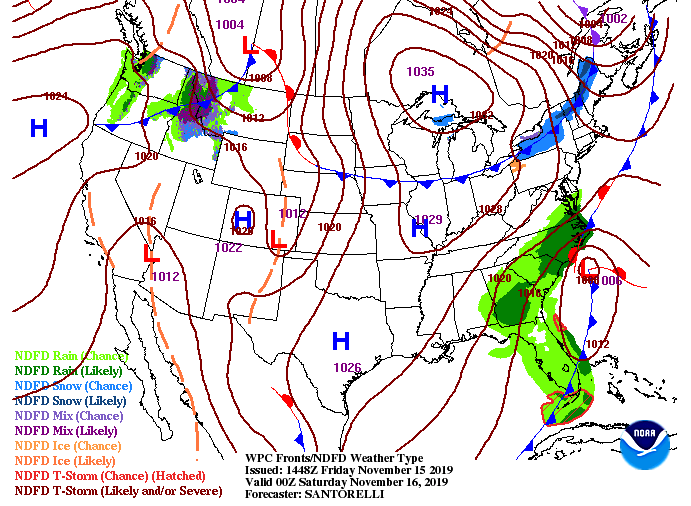 Model guidance shows the movement of these systems through the weekend. To the east, the low pressure system will move north forcing in a high. As we get further into the gif, a system in the Great Lakes region will bring some cloud cover the later half of Monday and the chance for an isolated shower overnight and into early Tuesday. Following will be another high that will keep things dry and sunny. We will also warm, looking to be back around 60 degrees by mid-week next week.  It will be a beautiful weekend to get out and enjoy the outdoors or see the Garth Brooks concert tomorrow night. It will stay on the cool side once the sun goes down so dress warm, but overall going to stay dry the next several days. Have a great weekend and share your outdoor adventures with us! We have some good news for your Thursday! In addition, to the gradually warming temperatures, the drought monitor shows back to normal conditions for nearly the entire state. We are still sitting abnormally dry around Chattanooga, but overall the last bit of rain and snowfall has brought the state back to normal.
As we work into the afternoon, highs will top out in the mid 40's with clouds building. A system will continue to develop bringing rainfall to our friends in the east (Carolinas and up the coast) but we will stay dry here in the valley. Working into tonight, the Smokies could see a shower or two, otherwise we will clear out by Friday afternoon. Looking at model guidance cloud cover below, lighter shades indicate increased cloud cover overnight. By tomorrow afternoon, darker shades return, suggesting sunny skies. High's to end the work week will be in the low to mid 50's.  The surface map shows the development of the system to our south. Moisture will soon be advected into the Carolinas through the day bringing rainfall in overnight. As for east TN we will see clouds through the night (locking in some warmer low's) before clearing out by Friday afternoon and into the weekend. A high pressure system to the west will bring in sunny and dry conditions for the weekend, where we will see high's near 60 on Sunday. 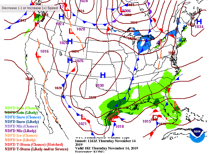 That will do it for today, so have a good one! Reminder: A full graphical forecast can be found under "Weekly Forecast" at the top of this page. |