|
We have started the morning relatively calm with temperatures currently in the mid to upper 70's. As we transition from AM to PM, showers are slowly making their way east. Currently residing in middle Tennessee, showers and storms will arrive by the the afternoon and evening hours. 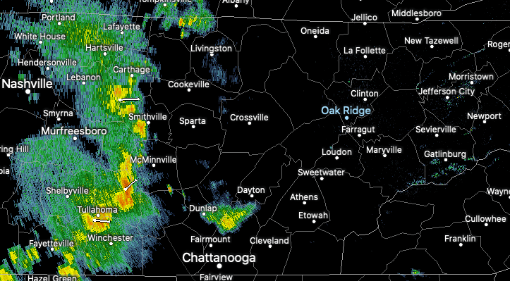 Just like yesterday, some could be strong to severe at times. In addition to gusty winds and small hail, flash flooding is again a concern. Parts of Knox, Anderson, and Blount counties received 4+ inches of rainfall last evening and more is on the way. If you are in low lying areas or flood prone regions, be sure to take the proper precautions ahead of time. 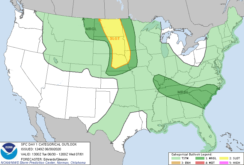 As seen below by future radar, showers and storms will continue working east and developing in east Tennessee. The bulk of this activity will fall in the later part of the afternoon and into the evening hours. Getting into the overnight hours, expect mostly cloudy skies and low's in the upper 60's. A very similar pattern sets up for Wednesday with scattered showers and storms throughout the day and the risk for isolated strong to severe thunderstorms. By Thursday afternoon, sunshine will return and temperatures will warm Friday and into the weekend. 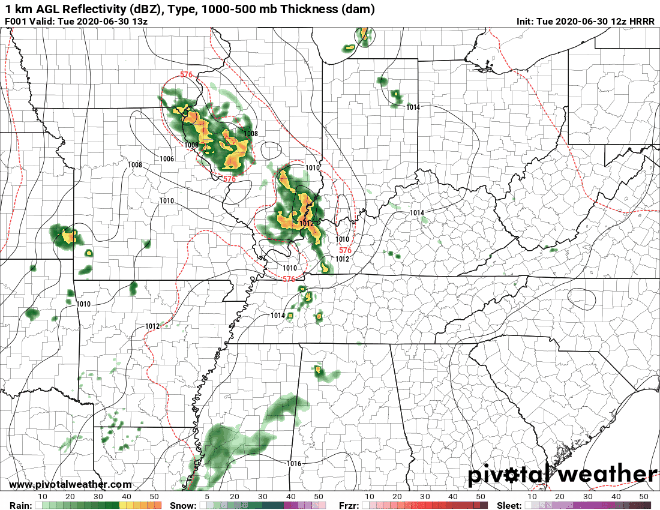 That will do it for now but be sure to check in for updates throughout the later part of today. We received some good reports of flooding, frequent lightning, and gusty winds so please continue that tonight and Wednesday! You can do so by email ([email protected]) or by social media @SecretCityWx
0 Comments
Showers and a few storms have developed and are working southeast around 15 mph. Heavy rain, small hail, and gusty winds are possible with this cell just north of Oak Ridge. As we continue to push into the afternoon hours, expect isolated to scattered showers to continue. 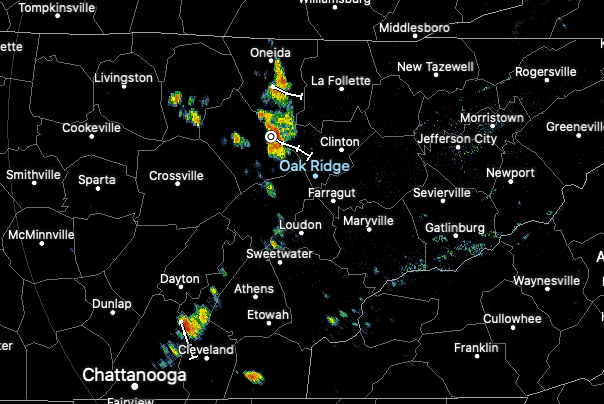 Future radar shows the activity expected ahead. Working into Tuesday, the bulk of activity will fall the later half of the day. Heavy rains, lightning, gusty winds, and small hail are possible tomorrow afternoon and overnight. Shower and storm activity will continue into Wednesday as well before clearing beings Thursday afternoon. By Friday, sunshine returns and so do the warmer temperatures.  A peak into tomorrow shows a Marginal risk for the entire state. Scattered showers are possible in the morning hours before widespread activity appears in the afternoon and night. The main threat tomorrow will be gusty winds, small hail, and isolated areas of flash flooding. Keep these in mind as we work through the day and remember to check in for updates! 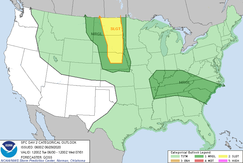 With a low to the north, we'll see rounds of activity the next few days. Keep the umbrellas handy and look out for flash flooding potential in heavier showers & storms. Better chances for sunshine and dry air return Friday and the weekend. Good afternoon and I hope you are enjoying your Friday thus far. Looking at a still shot of the latest CONUS satellite, cloud cover remains for the southern region of our viewing area. Fortunately, this is beginning to thin out as we get toward the PM hours. High's will top out today in the mid to upper 80's with an isolated shower or two possible. 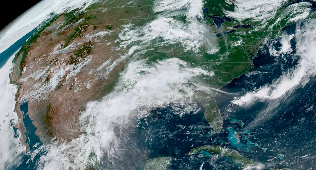 Looking into the weekend and early next week, a front from the west will meander east. This will provide shower and storm activity (bulk of this to the north) the second half of the weekend and early next week. With that said, scattered showers are still more than likely here at home. Our first round of scattered rain will be the second half of tomorrow. From then on, Sunday, Monday, and Tuesday will have the chance for scattered showers on and off throughout the day. 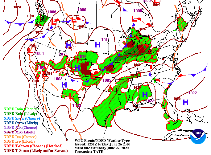 The latest trends show the bulk of precipitation to the north along the front. As winds shift out of the south this evening, higher dew points will slide into the area. I anticipate much of the shower activity later this weekend and into next week to come off the Plateau and from the north and west. Again, shower/ storm activity will be scattered so don't anticipate an all day kind of event.  Though the later half of the weekend doesn't look as pleasant as today or early tomorrow, there will still be time to enjoy some outdoor activities. If you want to monitor the latest radar, you can do so by clicking on the "Radar" tab at the top of the page. Have a great weekend and we'll let you know the latest! NewFound Gap is starting to clear out early this afternoon after a foggy start to the day. If you don't have any plans, it would be a great day for a hike. Temperatures will remain below average in the lower 80's (70's for the Smokies). 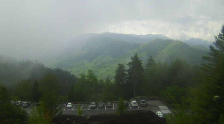 Turning our attention to what's ahead, there is not a ton to talk about. A few afternoon pop up showers are possible for southern east TN today, but otherwise partly sunny skies will be the main story. Much of the same can be said for Friday and Saturday as well. Isolated pop up showers and thunderstorms will mainly stay contained in the higher elevations with a few rolling through the valley. By Sunday, cloud cover builds with another system moving in. Showers are likely the second half of the day and again into the start of the work week (Monday).  Today's view of the Sahara dust plume shows it's slowly making its way north. Currently sitting in the Gulf, this will continue to work north and east providing some beautiful sunset/rises Friday and into part of the weekend. If you have the chance to see it, you should!  That will conclude today's forecast but go out and enjoy today as temperatures will remain below average. We also welcome your pictures...if you get a shot of a beautiful sunrise, a hike, lake trip, etc. share with us and we'll be sure to give full credit to you! Simply send it through email ([email protected]) or tag us on social media (@SecretCityWx). Happy Hump day to all! A mix of cloud cover and limited sunshine has been the main story so far this morning. As we push into the afternoon, a front will begin to work through. Ahead of this, we could see a few isolated showers by this evening. On the flip side, this will allow for clearing back side (AKA sunnier skies for Thursday). 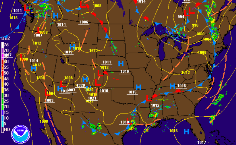 Thursday and Friday will be relatively the same. Lingering showers will move out by Thursday morning allowing for partly cloudy skies the remainder of the day. To close out the work week Friday, partly sunny with isolated pop up showers/ storms possible. These will stay mainly in the higher elevations, but a stray shower can't be ruled out here in the valley. Temperature-wise, expect to stay in the mid 80's today and tomorrow before warmer temps (mid to upper 80's) arrive Friday and Saturday.  Sahara Dust PlumeShifting gears, something rather interesting is taking place in the Tropics. Strong storms in Africa are kicking up massive plumes of dust from the Sahara. These occur every summer but this is one of the larger ones seen in many years. Taking a look first at the surface map, the Bermuda high, along with the African Easterly Jet, are steering this plume right into the southern US. High pressure systems are associated with clockwise flow, so we'll likely see some of the pros and cons of this dust plume here at home by the weekend.  To get a view of this plume, check out the "dirty cloud-like mass" south of Florida. This massive plume will begin working north bringing some positives and negatives with it. Sahara dust plume pros: 1) These severely reduce tropical development. Tropical depressions, storms, and hurricanes are, for the most part, out of the question while these are in the southern Atlantic. 2) They make for GORGEOUS sunrises and sunsets. With dust particles in the atmosphere, they refract light allowing for the many colors seen during sunrise/sunset. Be sure to pay attention to this as we work towards the weekend. Sahara dust plume Cons: 1) Awful air quality. Those with underlying health conditions could feel some of the impacts of this plume. The good news is the bulk of this mass will be to our south, so parts of Texas, Louisiana, and others will be affected the most. 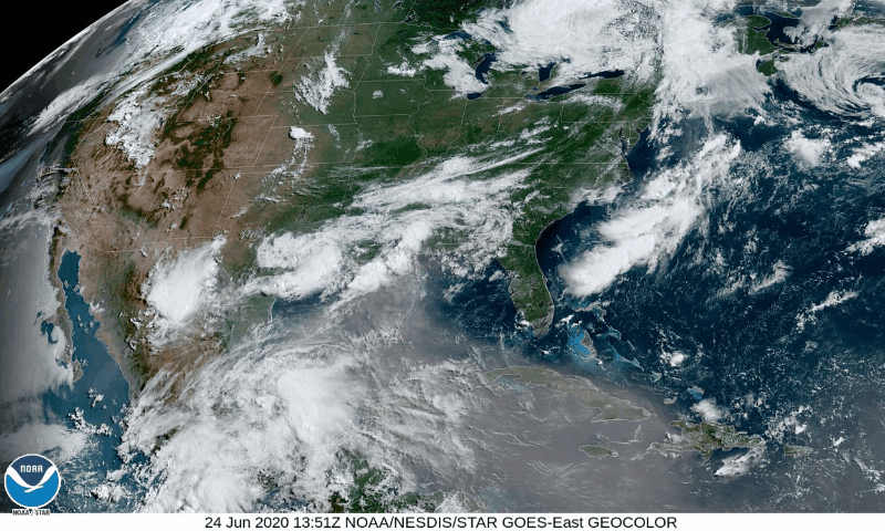 It will be exciting to see some pretty sunsets/ sunrises in the days to come, so take advantage if you get the chance! For now, enjoy sunnier skies Thursday with temperatures staying below average. Shower activity so far this morning has been moderate through the valley but that will transition to isolated showers this afternoon. In addition to showers beginning to lighten up, temperatures will top out around 80 degrees (7 degrees below average for this time of the year). 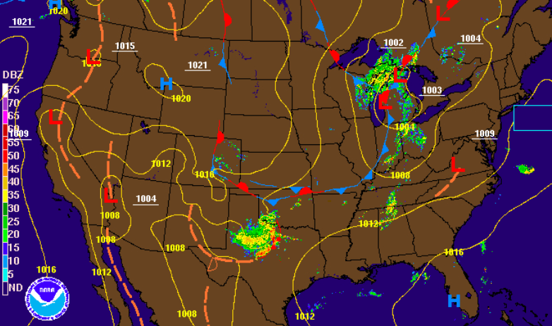 Looking at future radar, a front will move through Wednesday bringing drier air for Thursday and Friday. Until then, cloud cover and isolated shower chances will continue to be in the forecast. By the later half of the week and into the weekend, the general flow will be southern. That means humidity values rise, temperatures rise, and afternoon pop up showers/storms return.  As for the longer term, little positives are in sight. We will more than likely finish out June and enter July above average (likely in the upper 80's and lower 90's). We have been pretty lucky temperatures-wise so far, but that looks to change in the weeks ahead. 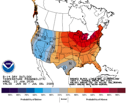 That will wrap it up for today but keep the umbrellas handy as showers remain possible this afternoon and again into Wednesday. Good afternoon! Conditions have been pleasant so far today but we'll see increasing clouds this afternoon. A look at the SPC shows a marginal risk for our area. Showers and storms are expected to develop later this afternoon and into the overnight hours. These will be scattered with heavier cells bringing the chance for gusty winds and small hail. 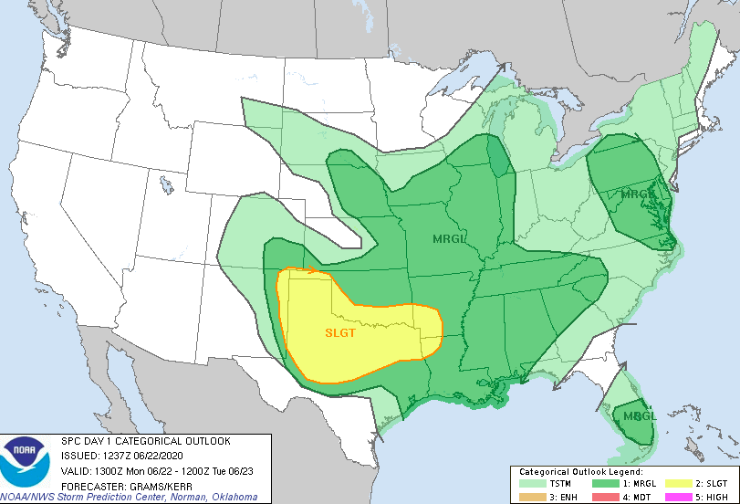 A low pressure system to the north and west will continue to slide eastward bringing showers/ storms throughout Tuesday and early Wednesday. Following a cold front (late Wednesday), clearing skies will allow for sunshine Thursday and Friday. Temperature-wise, we'll stay comfortable through Thursday before upper 80's to lower 90's return Friday and the weekend. 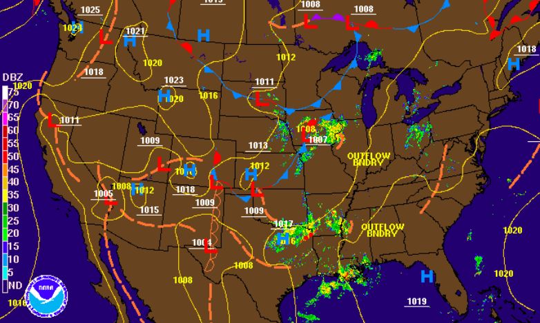 Showers are expected to develop later this afternoon and continue overnight. A second round of showers will move throughout the day of Tuesday (& early Wednesday) before a front clears things out late Wednesday. Sunnier skies return Thursday and Friday with isolated afternoon showers possible (mainly in the higher elevations).  Severe potential remains low but not out of the question the later half of today. Check in on Twitter & Facebook for any changes throughout the day. Have a good one and stay dry tomorrow; scattered showers are expected on and off throughout Tuesday. Good afternoon! We begin this Friday on the dreary side with cloud cover once again overhead. The good news is Saturday and much of Sunday will contain lots of sunshine as that "pesty low" works out overnight tonight. For now, isolated to scattered showers will be possible this afternoon with high's in the low to mid 80's. 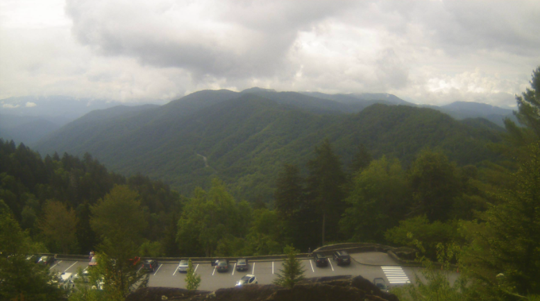 A brief area of ridging will arrive for Saturday and much of Sunday before a low to the north and west shifts winds out of the south. By doing so, scattered shower and limited storm activity will return the first half of next week. 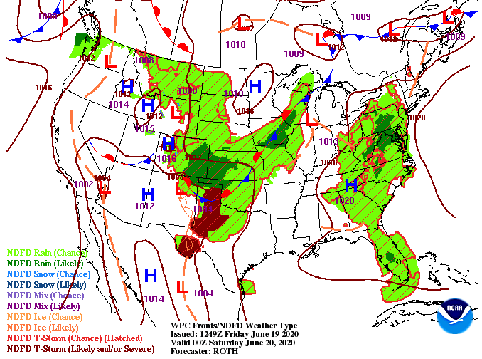 A look into this afternoon shows scattered showers developing before pushing out this evening. Saturday and Sunday (for the most part) will stay dry and sunny. An isolated shower/storm is possible during the afternoon hours each day but these will mainly stay in the higher elevations. As a new system works in to the north late Sunday, shower activity will return Monday, Tuesday, and Wednesday.  Future temperature trends show high's returning to the upper 80's and lower 90's this weekend. After a pleasant week in the 70's and low 80's, summer heat and humidity have returned. Feel like temperatures, especially Sunday, will feel closer to the mid 90's. Be sure to stay hydrated if you are outdoors for extended periods of time. 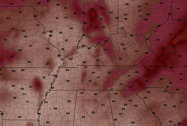 Though severe potential is very low today, some shower/storms this afternoon could contain gusty winds and small hail. We will let you know the latest as it develops but until then, I wish everyone a fantastic weekend! The pesty low to the east continues to leave cloud cover and shower chances throughout east Tennessee. Fortunately, drier air will begin working in the later half of Friday and through much of the weekend. As for today, scattered showers (and few storms) will likely develop in the afternoon and evening hours before fizzling out overnight. 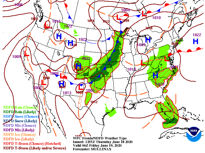 Model guidance depicts these showers through the later half of today before another round of isolated showers are possible the first half of Friday. By Friday evening, clearer skies will have moved in making for a sunny and warm Saturday. For the most part, conditions will stay sunny and warm through the weekend but another system will bring rain chances Monday and early next week.  A look into Saturday afternoon shows above average temperatures will make a return. High's will likely fall in the upper 80's with some regions (particularly to the south) topping out around 90. In addition to the above average temperatures, muggy conditions will also creep back in. This will make temps feel closer to the mid 90's by Sunday afternoon. 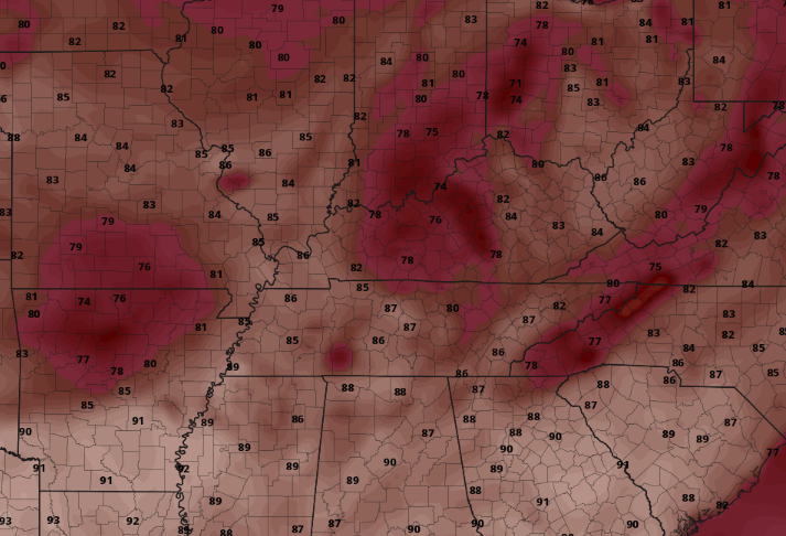 Enjoy the last bit of "early Spring" before summer like heat and humidity return. As always, we'll keep you updated with the latest radar scan & weather conditions throughout the day. You can also click on "radar" at the top of the page to know what conditions look like in your area. The view a few thousand feet up is a little different this morning than here at home. The Newfound Gap area of the Smokies are currently sitting in the upper 40's with heavy fog throughout the mountains. Getting closer to home, broken cloud cover is the main story with a few isolated showers possible this afternoon. Temperatures will remain comfortable near 80 degrees, but changes are soon on the way. 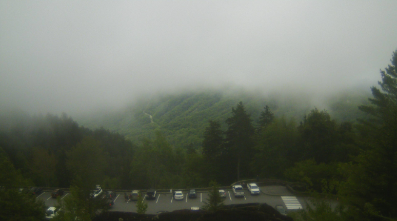 The low pressure system in the Carolinas will continue marching north bringing better rain chances for Thursday. By Friday, remnant isolated showers will be possible before a high builds in late Friday and through Saturday. This will begin to build back in those very warm and muggy conditions through the weekend. 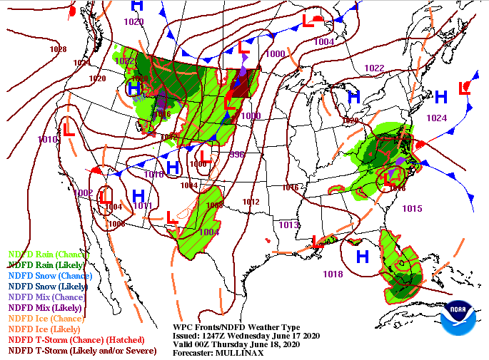 Looking at model guidance, an isolated shower or two remains possible this afternoon, otherwise we'll stick with broken cloud cover and below average temperatures. For tomorrow, wrap around moisture will provide widespread activity in the afternoon and evening before things clear out the later half of Friday. Lots of sunshine returns for Saturday and much of Sunday but so does the summer-like heat.  If you have plans this weekend, be sure to stay hydrated and cool. Feel-like temps could feel closer to the mid 90's at times. Until then, enjoy the last day or two of comfortable temperatures before late Spring to Early summer conditions return. |