|
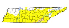
Very warm start to the work week with high's this afternoon expected to be in the low to mid 90's. Below is a map of total precipitation from September 1- 25th across the US. As you can see, very dry for the southeast with only 1 to 3 days of rainfall recorded. For Knoxville, we did not receive any rain in a 25 day period. 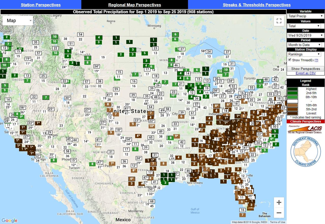 With these very dry conditions, the drought monitor continues to worsen across the state. Moderate drought through much of the state has led to burn bans from emergency management officials, so check with your county before burning trash, open campfires, etc. These drought conditions will only get worse the next week or so, as hot temperatures, dry conditions, and little to no rainfall is expected the next 5 days. 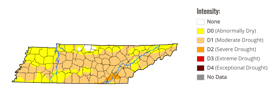 If you have been keeping up with us on social media, we showed the blizzard conditions through Montana and the Rockies this past weekend. This system will continue pushing eastward allowing for much cooler temperatures to arrive here by the end of the work week. Until then, a high pressure system will keep us warm, muggy, and dry. 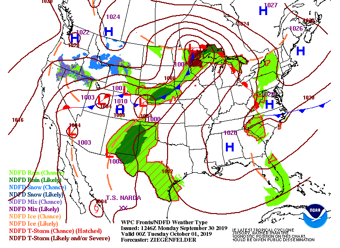 Little to discuss on the latest model guidance, as the high pressure system will keep things mostly sunny and warm through mid week. An isolated shower can't be ruled out this afternoon, but these will be limited to the higher elevations.  Stay cool the first half of the week, as we will have high's stay in the low to mid 90's and heat indices near 100. Keep in mind your heat safety and stay hydrated if you are to be outdoors for extended periods of time. There is a "light at the end of the tunnel", so be patient for cooler temperatures toward the end of the week and into the weekend.
0 Comments
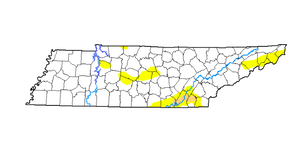
It is not too common to see a perfect lake forecast in October, but we have one this weekend. Typically, we have high's in the upper 70's to lower 80's this time of the year, but we will be dealing with lower 90's the next several days. Looking below at the expected temperatures across the US on Tuesday, very warm across the eastern half of the United States. This is all associated with a strong ridge, locking in warm temperatures, keeping us dry, and making things feel muggy outside. Oppositely to the west, very cold temperatures (associated with a deep trough) and that will provide the first major snow of the year for parts of Montana and the Rockies. This will likely be a very strong blizzard with feet of snow expected to fall in the Rockies early next week. This eventually will slide toward the east, which in turn, will bring some cooler temperatures and the chance for some much needed rainfall to east TN. We will be eyeing this as it grows closer to time late next week. 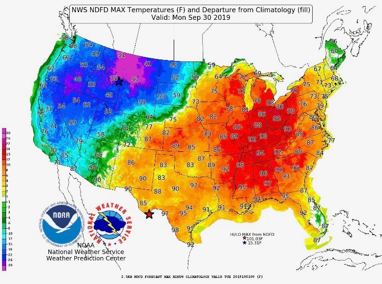 For our surface map, you can see the high pressure system keeping things dry across the region through the weekend. We could see an isolated shower (mainly in the higher elevations) tomorrow afternoon associated with the low to our north, but that will quickly move out leaving us sunny through next week. 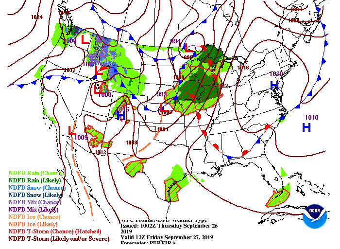 With the lack of rain last week and into much of this one, the drought monitor for the state has increased dramatically to a moderate drought. Toward the south for our friends in Bradley and Hamilton counties (Chattanooga), very dry with a severe drought intensity. Unfortunately, this will only get worse as we will remain hot, sunny, and dry over the next week or so. 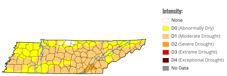 The latest model guidance shows the chance for an isolated shower in the higher elevations tomorrow afternoon. For us in the valley, though, expect to stay mostly sunny and dry with high's in the lower 90's. 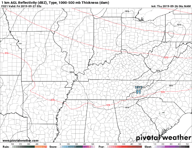 Thats all we have for your Friday, but go out and enjoy an early October lake day with mostly sunny skies and highs in the 90's. Have a great weekend! Good morning to everyone. We started the morning mostly cloudy with isolated rain in parts of Roane county. This has now traveled east into Knox and Sevier counties with the additional chance of showers as we get into the early afternoon hours. High's today will be cooler, thanks to the cold front and cloud cover, but this won't last long. To end your work week, we will be back in those upper 80's to lower 90's under mostly sunny skies. 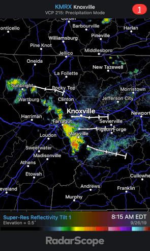 The current surface map shows the cold front across Tennessee. That will continue to slide through the area bringing with it those isolated shower chances and cooler temperatures. Unfortunately, this will move out quick as a strong high pressure system builds in tomorrow. This will clear the skies allowing for plentiful sunshine and warm temperatures. 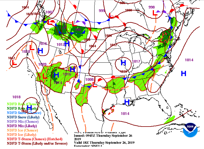 The latest model guidance suggests we could see some additional shower chances as we get into the early afternoon. We are definitely in need of some rain as we have gone almost a month without even a trace of precipitation in Knox county. These showers will quickly move out this evening, allowing for clearing skies overnight, and most sunny skies on your Friday.  I hope everyone sees a few sprinkles today as mostly sunny skies and hot temperatures will return tomorrow and through the first half of the week next week. Good morning to everyone! We started pretty cool this morning with temperatures in the mid to upper 50's on the way out of the door. Unfortunately, we will warm up quickly with high's expected to be in the upper 80's by this afternoon.  As we get into Thursday, a weak cold front will move through the area. This will give us the chance to see some spotty showers (very similar to Monday afternoon), as well as high's back in the mid 80's. Closing out the week, another high pressure system will build in providing plenty of sunshine and warm temperatures through the early half of next week. 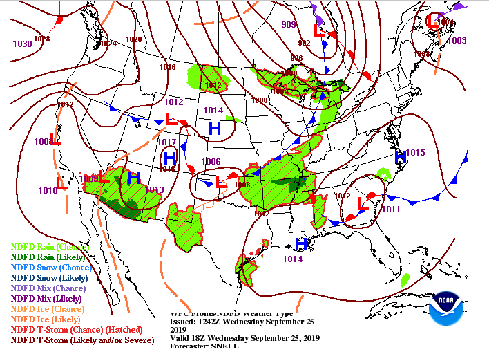 Taking a look at the latest model guidance, we will continue to stay dry this afternoon due to that high pressure system. As we get into Thursday, a cold front will slide through bringing the chance (30% chance) of some spotty light showers. This model tends to over predict rain amounts, so expect very similar results to what we saw Monday afternoon.  That wraps up your Wednesday forecast but I hope everyone has a good rest of their day! There is some good news and bad news in the forecast over the next week and a half. Taking a look below, we see the bad news. The later half of this week and through the early portions of next week, expect temperatures anywhere from 9 to 15 degrees above the average for this time of the year. A very strong ridge will lock in hot temperatures, muggy conditions, and mostly sunny skies Friday through mid next week. The good news is this afternoon will feel more seasonal with highs in the mid 80's, as well as low humidity. We could also see highs back in the lower 80's to upper 70's toward the end of next week (in a week and a half) so check back in with the latest forecast regarding that. As you can see, much cooler temperatures on the west coast expected early next week, which will eventually slide to the east providing a bit of relief from the 90's. With cooler temperatures we could see some much needed rain as well. Like I said though, check back in as this is 10+ days out and many changes are likely to occur. NOTE: With these strong temperatures gradients early next week, we could see severe weather in the Midwest. We will be eyeing that, and the changes expected to occur in our area, the next several days. 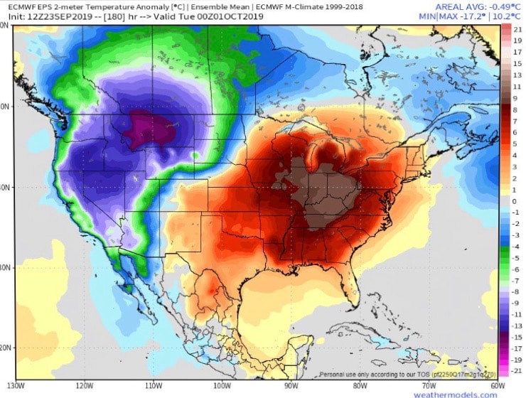 Looking more short-term, we will stay dry this afternoon and into Wednesday thanks to the high pressure system. As we get into Thursday, though, another weak cold front will move through the area giving us highs back in the mid 80's and a chance for a spotty shower. 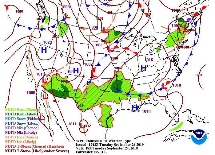 Model guidance shows little activity through this afternoon and tomorrow, but toward the end of this GIF, we do see some spotty showers Thursday afternoon. Don't get too excited though as this next system will be very similar to what we saw yesterday (very light, isolated, and quick moving). We will quickly clear out Friday as that strong high builds in.  Thats all we have for your Tuesday but check out our video update below and have a good (and comfortable) day! Today is officially the first day of Autumn but its not feeling like it as we are expecting high's in the mid to upper 80's this afternoon. We will cool down a touch for your Tuesday as a weak cold front will slide through this afternoon. This could provide us with some limited shower potential (30% chance) overnight, but these will be light and quick moving. Tuesday and into the later half of the week a high pressure system will slide in locking in warmer temperatures and keeping us rain-free. 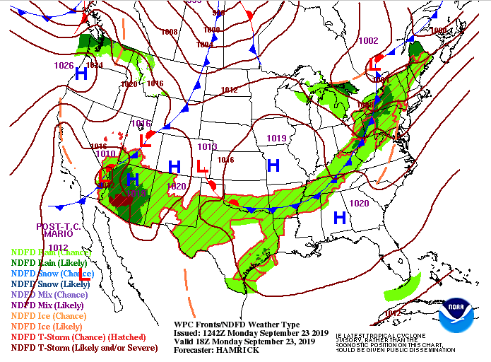 Looking at our model guidance (below) we see how the drier air aloft will keep rain chances limited tonight. We will definitely be hoping for some much needed rain, but amounts and spread potential (how widespread these showers will be) will both be low. Tuesday we will stay dry with mostly sunny skies and highs in the mid 80's.  Taking an extended look into the first month of Fall, we will continue this pattern with dominate ridging being the main story. This will keep in warm temperatures and limited rain potential the next several weeks (into at least the first week of October). 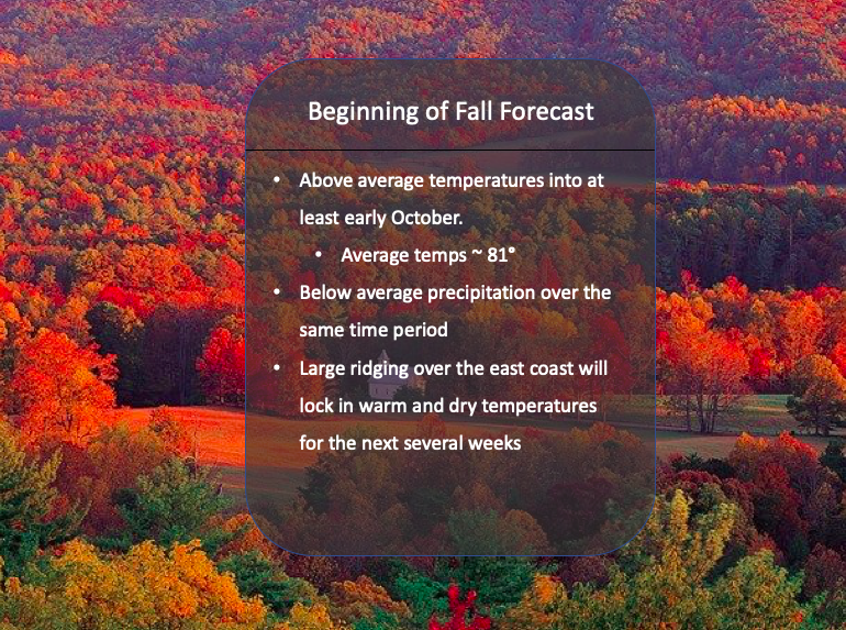 Thats all we have on your Monday, I hope everyone has a good day! We will be hoping for some rain showers this evening, followed by cooler and drier air Tuesday. Another pleasant day to end your work week with highs expected to be in the mid 80's. For this weekend we will remain pretty dry and with this, these dry days have started taking a toll. If you recall, on Monday we presented this same graphic showing only isolated areas (NE, Plateau, and Chattanooga) under abnormally dry conditions, but now, the entire state is under abnormally dry. This is an issue we need to be eyeing in the next several days as it will likely only get worst with little rainfall expected in the forecast.
Taking a look at the surface map right now, we will remain dry into the weekend with a high pressure system sitting on the east coast. Temperatures may feel a little cooler as dew points are expected to stay low. This will make temperatures feel closer to their true value versus the muggy and sticky conditions we have felt much of this month. As we get into the later half of the weekend, we will have a low slide to our north. With this will be a cold front that could provide the chance for some light showers Monday afternoon. We will also cool down a bit with high's in the lower 80's. 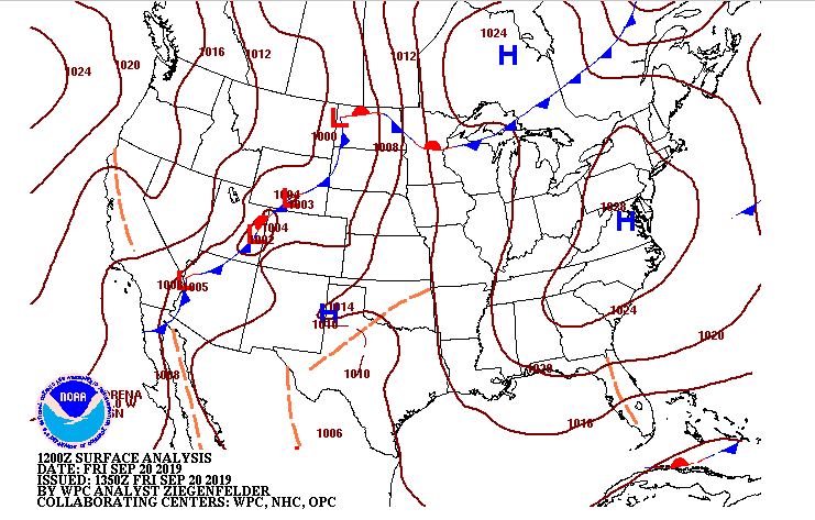 Looking at our model guidance as it rolls through, we do see by Monday afternoon a line of showers slide in, but with the dry air in place these will quickly break apart giving only isolated to scattered shower potential. As I said, though, very limited shower potential in the next week or so, which will likely contribute more to the overall drought we are seeing. 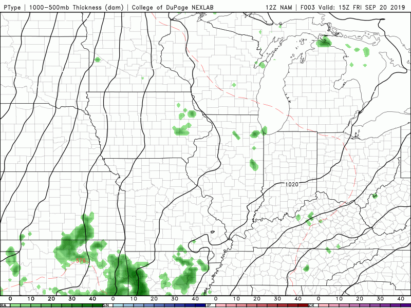 Thats all we have for your Friday but go out and enjoy a "cooler" and drier weekend. We would love for you to share your pictures with us if you are hiking, on the lake, viewing the sunsets etc. You can send them to us at [email protected] or tag us on our social media @SecretCityWx (Facebook & Twitter) where we will give you full credit. Have a good weekend! I hope everyone is enjoying a bit of cooler air for your Thursday. Taking a look below, we see where that cold front made an impact with much of the east coast nearly 8 degrees cooler than this time yesterday. For this afternoon, we will have high's in the low to mid 80's and partly cloudy skies. 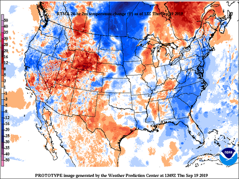 Looking ahead here we will have a high pressure system (the one that brought us cooler air today) move south, providing warmer and more muggy temperatures by this weekend. 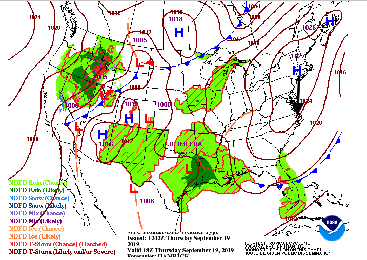 Little change in the model guidance with an isolated shower or two possible this afternoon. Those will stay in the higher elevations, associated with the thicker cloud cover and front that moved in. Overall though, we will continue to stay dry for the next several days with the greatest rain chance not coming until next week. Even with some hope on the horizon, rain chances look low within the next 5 days. 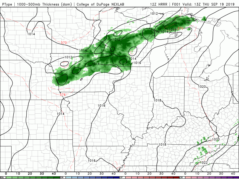 Thats all we have for your Thursday, but I hope everyone has a wonderful day. Happy hump day and Wednesday to everyone. A little bit cooler out there today with highs in the upper 80's, near 90. Pleasant news in the forecast though, as cooler and drier temperatures will funnel in Thursday. Taking a look at the surface map below, you can see a high pressure system in the northeast. Due to the clockwise flow of high pressure systems, cooler and drier air from Canada will move in, allowing for a taste of Fall Thursday and Friday (annotated by the blue arrows). 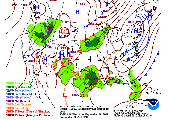 Today will be another day of dry conditions across the valley. We could see an isolated shower or two develop in the higher elevations, but overall very limited rainfall expected. As we get into Thursday, that cooler and drier air will move in allowing for a mostly sunny afternoon.  Taking a look at the CPC (Climate Prediction Center's) 3 to 4 week outlook for precipitation, well below average precipitation expected. This isn't very good news, as we are in need of rain across east Tennessee. Looking at the latest data our best chance of rain in the next 7 days will come Tuesday (next week) as another front will move through allowing for limited chances of rain ahead of it. We will keep a close eye on that as we get into your weekend. 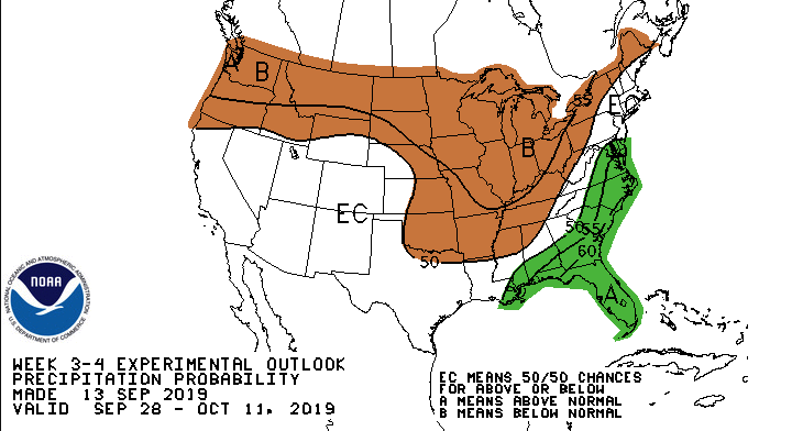 Don't forget to check out our daily video updates. We provide lots of extra content not seen on our written forecasts. Have a great rest of your Wednesday and prepare for some much needed cooler temperatures as we get into your Thursday. Pretty warm start to your Tuesday with current temperatures (as of 11:45am) sitting in the upper 80's across much of the region. By this afternoon we will have high's in the lower 90's and feel like temps in the mid 90's. Something we should be paying attention to is our drought monitor. With drier air and cooler temperatures expected to move in, we need to be cautious for wildfires. Overall, the drought intensity across the state isn't too bad with abnormally dry conditions in the NE and Plateau. Near Bradley and Hamilton counties (Chattanooga) we are a bit more dry with moderate drought currently taking place. I will keep you up to date on these drought conditions the next couple of week, as limited rainfall is in the forecast.
I wanted to share this awesome GOES-16 EAST Satellite imagery with you from last night around 7:30pm. You can clearly make out the transition from day to night across the US, as well as hurricane Humberto off the east coast. As for the east half of the USA, there is limited cloud cover and that's due to the high pressure system that's been dominating the area. 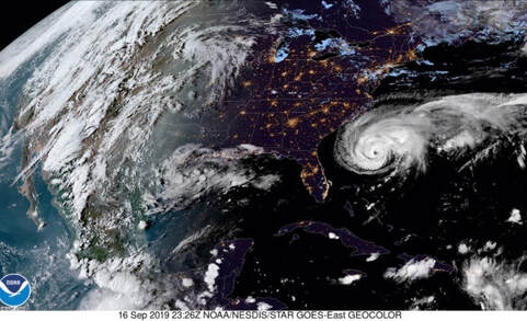 As you can see, the high pressure system will stick around today. Working into Wednesday, though, it will begin to slide out allowing for cooler and drier air to move in for the later half of the work week. It'll feel a little closer to fall with those highs in the mid 80's and dry air. As we get back into your weekend, though, warmer temperatures and more humid air will begin to funnel back in.  Little activity expected this afternoon and into your Wednesday, as that high pressure system will do its job. Tomorrow afternoon a few of us in the higher elevations could see an isolated shower or two (20% chance), but overall I expect for most of us to stay dry and warm once again.  Thats it for your Tuesday forecast, but there is some cooler and drier air in the forecast. If you can push through today and tomorrow, anticipate better conditions to close out your work week. |