|
Happy Friday! Many of you woke up this morning to mostly clear skies, but those clouds have managed to find their way into our area. Expect these to continue increasing throughout the day. We could see a sprinkle or two in spots this afternoon and tonight, but expect for most of the region to stay dry. For Saturday, expect mainly overcast skies and a high in the mid 70's range. Saturday night is when the rain, associated with a low, will reach east TN. Moving into Saturday night we will see those rain chances increase, as I briefly stated above. The timing of this event will be mainly Saturday night. The rain is set to arrive sometime between midnight and 3 am and last into the late morning/early afternoon hours on Sunday. This may be good sleeping weather for some, as this line of storms is likely to produce some heavier rains and thunderstorms at times. At this point, the severe threat is not there due to the lack of Convective Available Potential Energy (CAPE), moisture convergence, and many other important ingredients. I will let you know if any of this changes over the next day and a half. Back to the rain...following the showers will be some cooler temperatures, due to a cold front. This cold front will drop temperatures converting some rain into frozen precipitation in the higher elevations. Expect no accumulations at all for east TN but there is a chance at some traceable amounts in the highest elevations of the Smokies. After the rain clears out Sunday, temperatures will be a bit cooler (in the lower 50's) and clouds will begin moving out. Monday we look dry with the sun returning before Tuesday we could have another chance of rain. I will update you more on what you can expect this coming week sometime this weekend, until then, stay dry and don't forget your light coats!
0 Comments
Today is a BIG day for Orange country as we face off again the Perdue Boilermakers in Louisville, KY. Because this is such a high octane game and we are so close to such a rare sight, I am sure many of you plan to head to the game this afternoon, if you are not on the roads already. As I am sure the game is the ONLY things on your minds, let me quickly let you know what you can expect weather wise. Right now temperatures are currently sitting in the lower 60's for the Knoxville area and will increase to the lower 70's. We also have beautiful blue skies over head with a few high altitude clouds in some spots. As you head to Louisville, you can expect a similar story for the remainder of the day. I would advise a light jacket or wind breaker, as it is breezy in KY currently and the low will be in the mid 50's tonight. This afternoon into the evening clouds will build ahead of moisture moving into the area tomorrow. For those staying the night in Louisville tonight, include a rain jacket or umbrella in your bag as it will be wet at times tomorrow. Expect the rain to be on the lighter side of things. Rain will likely arrive in the morning hours Friday in Louisville (between 7-10). This rain will stay mainly in Kentucky, leaving east TN with partly cloudy skies and dry conditions.
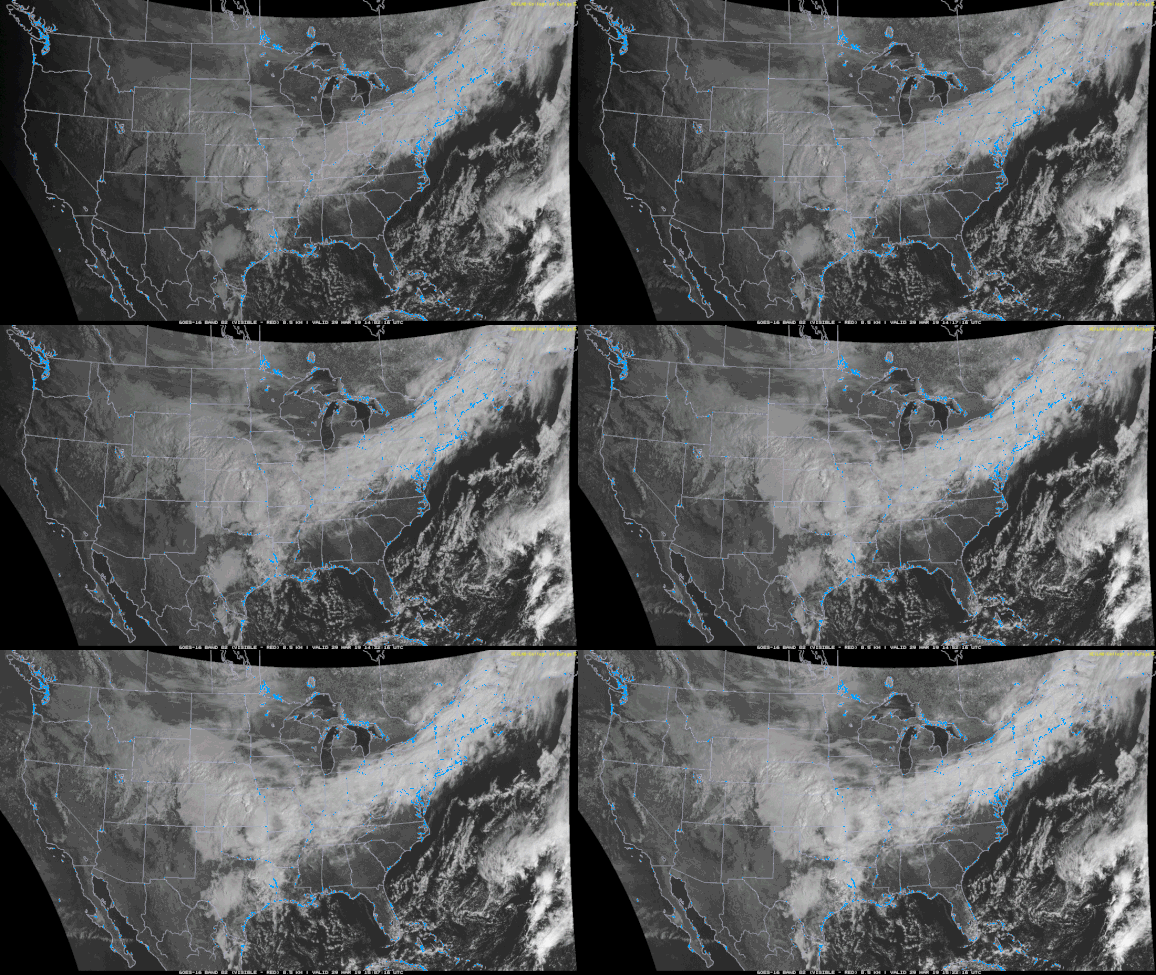
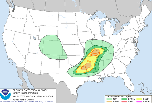
For those heading to Louisville, have a safe drive and be weary of rain showers Friday morning and scattered showers throughout the day. Go VOLS! Forecast For Louisville: Tonight: Mostly cloudy with a slight chance of a stray shower. Breezy with gusts up to 25 mph. Low in the mid 50's. Tomorrow: Showers likely in the morning hours and becoming more widespread in the afternoon. High in the mid 60's. Forecast For East TN: Tonight: Partly cloudy with a low in the mid 40's Tomorrow: Clouds building throughout the day leaving partly cloudy to cloudy skies. High in the low 70's. Overall, it was a pretty weekend filled with blue skies and comfortable temperatures. The overnight hours were a bit chilly, but the temperatures were around average for this time of the year. Today we started with partly cloudy skies and ended mostly cloudy. Clouds are expected to increase overnight ahead of rain that will be moving in Monday. Do not rule out the possibility of some scattered showers overnight tonight, as there are some scattered light showers south of Knoxville around Sweetwater, Athens, and Maryville. These will move out soon, leaving cloudy skies overnight. As for 12z today to 12z tomorrow (8am today to 8am Monday), the SPC (Storm Prediction Center) has released their thoughts on the up and coming system (below). Luckily, the severe threat is in areas like Arkansas, Louisiana, and Missouri. The mechanisms for severe weather in our area appear to just not be there. So with this in mind, we can expect rain much of tomorrow and for it to be heavy at times. Overall totals for this event are up to half an inch of rain. The main threats are localized flooding. Even though we have had lots of sunshine as of late, much of the ground is still saturated, so with an added half an inch of rain, flooding is possible in some areas. Once the rain moves out Monday night, you can expect sunny skies for the rest of the work week. On top of the plentiful amounts of sunshine are warmer Spring temperatures. By Friday you can expect high's in the low 70's. I will let you know if there are any changes with the event tomorrow, but until then don't forget your umbrellas! Also check out our newest tab "radar" to see where the rain is in your area.
It has been a very wet year to start with record amounts of rainfall across east TN. Rainfall amounts for east TN have been a record amount of 15 inches + for the month of February (as measured & reported by NWS Morristown). Not only has east TN been very wet since the start of 2019, but the entire nation has received record rainfall. Just to give some statistics:
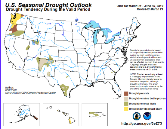
NOAA also agrees that the likelihood for drought seems very unlikely and all this moisture will stick around for awhile longer. So, prepare for a likely hot and muggy summer in east TN.
It has been an interesting day weather-wise. Mostly cloudy skies dominated the day with scattered showers this afternoon and into the evening. We had many reports of hail in and around the Knoxville area. This was made possible due to the cold air aloft. As stronger convective (warmer moist air rising & colder denser air sinking) storms rolled through, the lifting of air was much stronger. Hail is created initially by water freezing, sinking, being lifted again where water freezes to it, and then sinking again. This process continues to happen until the hail "ball" is too heavy from water freezing to it for the updraft to "hold" (lift anymore) and therefore falls to the ground as hail. This is why in very strong storms, hail tends to be much larger. Today, the cold air in the mid to upper atmosphere allowed for ice particles to form much quicker than normal. Tying this with the stronger updrafts within stronger convective storms, penny sized hail formed in many east TN areas. So what can East TN expect next? Lots of sun and warmer temperatures. A high pressure system will be moving in from the Minnesota/Canadian border bringing with it sunny skies and warmer temperatures. It definitely will feel like Spring with sunny skies and high's in the 60's Friday, Saturday, and the first half of the day Sunday. Late Sunday and into the early part of next week, showers return. Some of these showers could be heavier at times, but I will keep you updated as time gets closer. Until then, enjoy some vitamin D and warmer temperatures to end the work week and into the weekend.
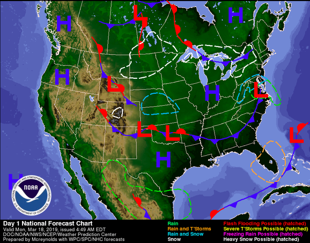
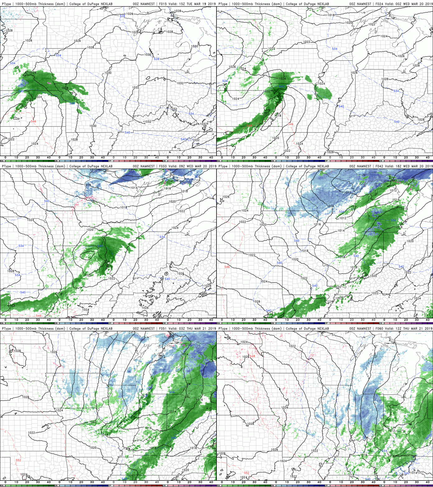
Due to the abundance of sun, there has been little to talk about weather wise. These clear conditions can be thanked in large part to the high pressure system that made its way into the Ohio Valley. It will stick around tomorrow, giving us sunny skies once more, before moving off of the coast. Behind this High is a Low, located to the north of North Dakota (in the graphic below). This low pressure system will move east bringing some tailing showers into our region. Most of these showers will occur late Wednesday night and into early Thursday morning. During the day Thursday, some scattered light showers are possible, but do not expect these to last very long. Below is the latest North American Model Mesoscale CONUS NEST run for the slight disturbance we will see Wednesday night into Thursday. After some minor rain showers, around a tenth of an inch total, expect sunny skies to return the rest of the week. For the rest of the week (Monday through the weekend) expect sunny skies and warming temperatures. We will see temperatures flirt with near 70 degrees by Sunday. Early next week rain showers will return, so enjoy this beautiful Spring (Starting March 20 @ 5:58 PM) weather while it lasts.
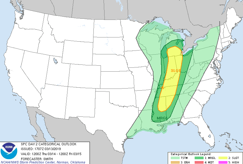
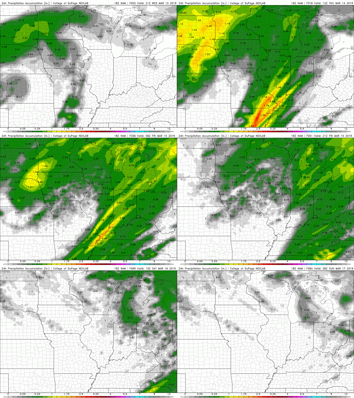
Happy Hump Day! It has been a pretty day today with partly cloudy skies throughout. Expect clouds to begin increasing overnight and during the day Thursday; ahead of a front moving into our region. Ahead of this front, there is potential for some thunderstorms, heavier winds, and heavier rains. As of now, the ignition "ingredients" for this system are mainly in western Tennessee. This graphic (below) was released by the National Weather Service (NWS) Storm Prediction Center (SPC). Seen in this graphic is a relatively thin, but long line of a slight risk. For those in this area, they can expect thunderstorms, stronger winds, heavy rain, the possibility of hail, and the slight chance of isolated tornados. For us east "Tennesseans" we can expect some thunderstorms, heavier winds, and heavy rain. This system will be quick moving, arriving sometime around 11pm and moving completely out by 3 pm Friday. Not to get confused, I am referring to a single line of heavier rain/storms than scattered rain for the rest of the time. For tomorrow (Thursday), clouds will be increasing throughout the day. Scattered showers are possible throughout the day but these will be light and few and far between. The wind is also something to look out for, as gusts can be up to 30 mph tomorrow afternoon. I would not be surprised if the NWS released a wind advisory ahead of tomorrow afternoons winds into Friday morning. As I said, the main weather maker will arrive Thursday evening. Friday we will feel the remanence of the system with a chance of some showers (but these will end early), allowing for clouds to begin moving out Friday afternoon and overnight. This will allow for a clear weekend, with Saturday and Sunday being mostly sunny with high's in the mid 50's. At this point (roughly 30 hours out), there is plenty of time for things to chance with this system. There is a lot of discrepancy in the models dealing with timing and exact placement, so change is possible. Currently, the moisture values are pretty weak, but I expect these to increase as we move through the day tomorrow. Thursday will be pretty warm and partly cloudy allowing for the potential of convection, (the transfer of heat) providing the ingredients and energy for a weather event. In the end, rain totals will not be too high, but with already saturated surfaces, minor flooding/flash flooding is possible, especially if the storms sticks together long enough to impact our area. Below shows the 24-hour precipitation amounts. In total, there is a chance for the "slight" outlook to be pulled a bit farther east, but the bulk of the severe threat is located from western Tennessee all the way into southern/mid Ohio. As always, I will be the first to update you on any changes with this system! If you have Twitter, follow us, as this will be the quickest way to update you. If you do not, you can follow along here by scrolling through our tweets on the right side of the home page.
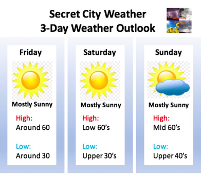
Sources: NWS, NOAA, COD Weather It was a beautiful Sunday after some heavy rain Saturday night. We were left with partly cloudy skies today and high's near 70 degrees! Monday looks more or less the same, with cloudy to partly cloudy skies and temperatures in the lower 60's. These conditions will continue through Wednesday until our next rain event arrives. With the rain will come cooler temps the second half of the week. As seen below, we will stay mostly dry until late Wednesday. There is a chance of some light stray showers Monday afternoon but nothing impactful. I will update you mid week with what you can expect precipitation wise Thursday and temperature wise the rest of the week. Enjoy the mild temperatures and sunshine through Wednesday before the rain and cooler temperatures creep their way back into east Tennessee. Don't forget to check out our "Weekly Forecast" tab for your daily weather outlooks.
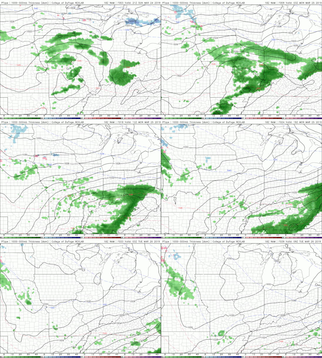
Good afternoon and happy Friday to everyone! I hope everyone enjoyed the sun we had at the beginning of the week along with the warmer temperatures. Sadly, winter is not over for us just yet. For tonight, we can expect some light scattered showers, but staying mostly dry. Saturday looks to be mostly cloudy with some breaks in the clouds possible throughout the day. Overall, Saturday looks to be the best day for any outdoor activities as it should be pretty dry and comfortable with a high in the mid 50's. Below is the latest GFS run. A cold front is expected to come through late this weekend bringing with it much colder temperatures (seen below). Sunday is the "game changer" as a low pressure system is expected to move through the south of Tennessee bringing with it lots of rain and colder temperatures. Below is the latest NAM (North American Model) run at 18z precipitation mode. Rain is expected to arrive Saturday night and early Sunday morning. This system is expected to bring moderate amounts of rain to our area. Final totals Sunday are anywhere from 1 to 1.5 inches of rain. Following the rain Sunday is a cold front that can bring the potential for some lingering snow showers/flurries. These snow showers will mainly stay in the plateau and in the smokies, but we can't rule out the possibility of a snow shower or two in the valley. Overall, this is a pretty quick moving system as it will move out Sunday leaving mostly clear skies for the start of next week. Unfortunately, cooler temperatures are to be accompanied by the clearing that is to take place Monday and Tuesday. Recap: Mostly cloudy the rest of today with cloudy to partly cloudy skies Saturday. Saturday will be the best day to run errands or do any outside work. On Sunday, the rain will move in (heavy at times) with a cold front to follow brining colder temperatures for the start of the work week and mostly sunny skies. There is a chance to see some snow showers but no accumulation is expected. For the start of the work week, expect mostly sunny skies and much cooler temperatures.
As always, don't forget to check out the "Weekly Forecast" tab to keep up to date on what you can expect weather-wise each day. Don't forget to check out our Twitter (@SecretCityWX) for daily updates, as well. If you do not have Twitter, you can view it through our home page on the far right side! |
Your trusted source for everything weather in East Tennessee.
Social Media
|

