|
Quiet and quaint conditions the next several days, with the primary theme of dry weather and warming temperatures expected. We will be off tomorrow through next week, but remain active on Twitter and Facebook so be sure to follow along there. Have a good one and enjoy these pleasant conditions! Pre-recorded for 5pm weather broadcast
0 Comments
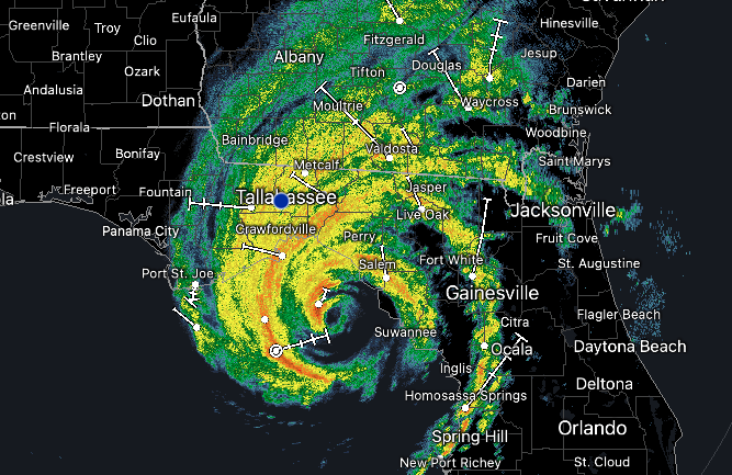
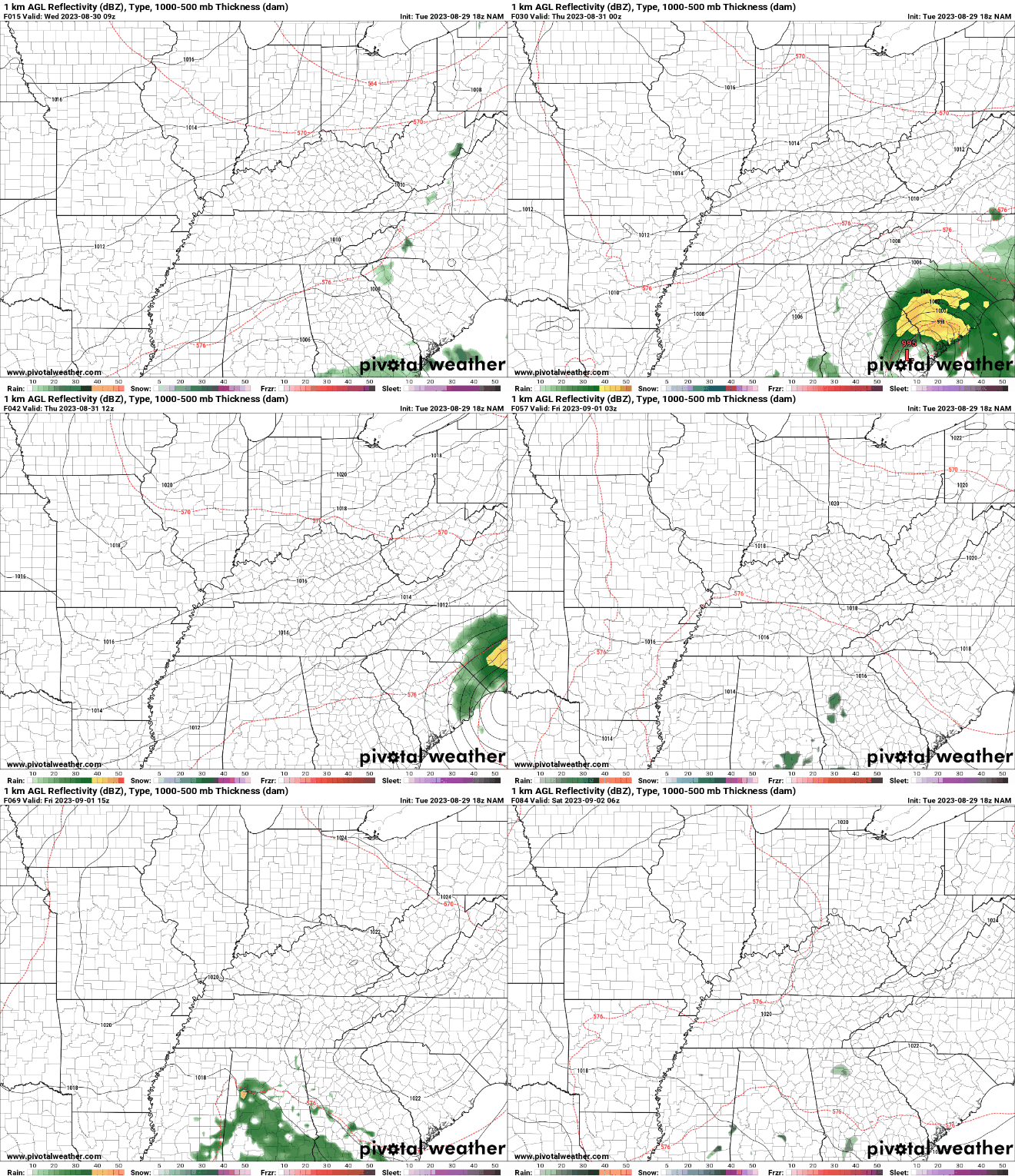
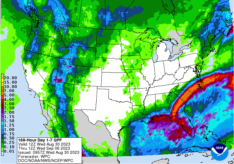
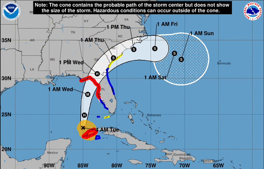
Good morning! Category 4 hurricane Idalia will be making landfall within the next couple of hours in Northern Florida, before working across the Deep South and back into the Atlantic by Friday. Check out the intensity of its outer bands and even the eye is clearly visible. For those interested, head outside this afternoon and the cloud cover you see will be associated with this system! The good news is, no real impacts are expected with Idalia. She will work through Georgia and the Carolina's before making her way in the Atlantic and hooking southeastward by the weekend. That said, a very isolated shower or two can't be ruled out this afternoon in the southeast, otherwise high clouds from the system will be the main result locally today. Cloud cover will clear out overnight, bringing an extended stretch of dry weather and warming temperatures each day thereafter. In fact, check out the precipitation forecast from the Weather Prediction Center (WPC). No rainfall (outside of the low end chances in the south today) are expected over the next 7 days. I could almost go as far as saying we may not see rainfall in even the next 10 days. Time will tell, but a strong area of high pressure will slide east through early next week, bringing a return of seasonably warm air to the region. Temperatures will be comfortable through Friday, before veering on the warm side of average Sunday into next week. Highs will range from the low to mid 80s, warming to the upper 80s and 90s Sunday through Tuesday. Have a good one and enjoy the beautiful stretch of weather we have through the end of the week. I will be off this next week for vacation, so follow along the latest forecast via Twitter & Facebook. Pre-recorded for 5pm weather broadcast
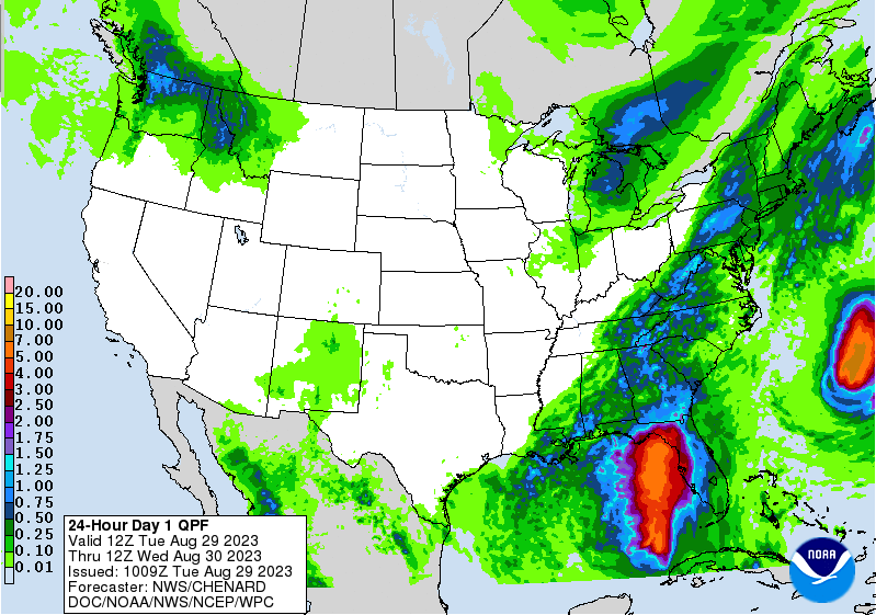
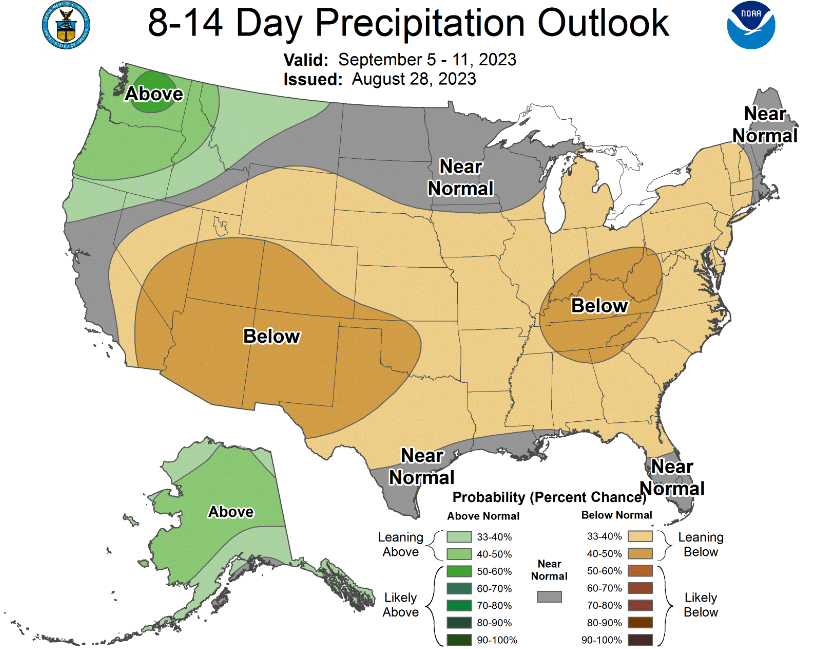
Good morning! Showers and storms are already ramped up, with activity on going across SE Tennessee to Maryville this morning, with scattered showers in the plateau. Expect for most locations to see a bit of rainfall today, some of which could be heavy. Isolated flooding can't be ruled out. As you can see below, rainfall amounts are expected to vary between a quarter of an inch to an inch and a quarter depending on where you are. Those further south and east (closer to the boundary) will see the highest rainfall amounts, while those further north and west generally can expect less. After this, an extended stretch of dry weather looks likely (more on this below). After this sluggish boundary dips south into tonight, Hurricane Idalia will make landfall midday Wednesday across the armpit of Florida. We expect this to rapidly intensify in the warm Gulf waters today, where The National Hurricane Center has this making landfall as a major hurricane (category 3 or higher). We think a category 3 or 4 is likely, with a 5 not entirely out of the cards. Something worth monitoring over the next 24-36 hours. Reach out to family/friends in these areas and come up with a game plan- in guidance with local officials. Significant flooding, hurricane force winds, tornado potential, and more all associated with this system. In terms of impacts locally, there will be minimal. Idalia will bend northeast with time, where increased high clouds will be noted across East Tennessee. A few locations in the far south/east could see isolated to scattered showers, but most of the area will stay dry Wednesday. High pressure then fills in Wednesday night, bringing dry and warming weather through at least early to mid next week. In fact, this comes from the Climate Prediction Center. Following along with what has been said, an extended dry period is expected. High pressure will shift east with time, squeezing out any rainfall chances through at least early next week. This is well reflected by the higher confidence of below average rainfall, along with (not shown) high confidence in above average temperatures. We could see values back up in the upper 80s to low or mid 90s a week out from now. Don't forget to view our video forecast below more even more information. Once we make it through today, and for a portion of the area tomorrow, dry and warming temperatures are on the plate for the foreseeable future. Have a good one, stay dry today, and enjoy the weather heading into mid and late week. Pre-recorded for 5pm weather broadcast
A slow moving frontal boundary will keep the threat of showers and storms in today and Tuesday. High pressure then fills in the second half of the work week, keeping the area mostly dry. Tropical system Idalia will make landfall sometime midday Wednesday, potentially as a major hurricane, but should have little to no impacts to East Tennessee as it works south and east of us. Check out our video forecast below for more information. Pre-recorded for 5pm weather broadcast
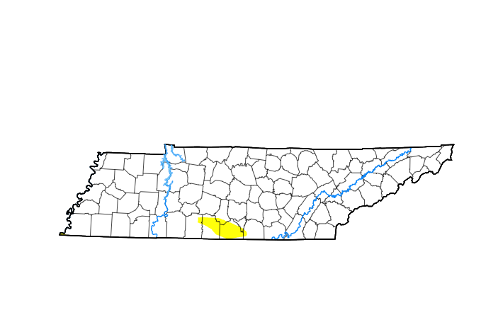
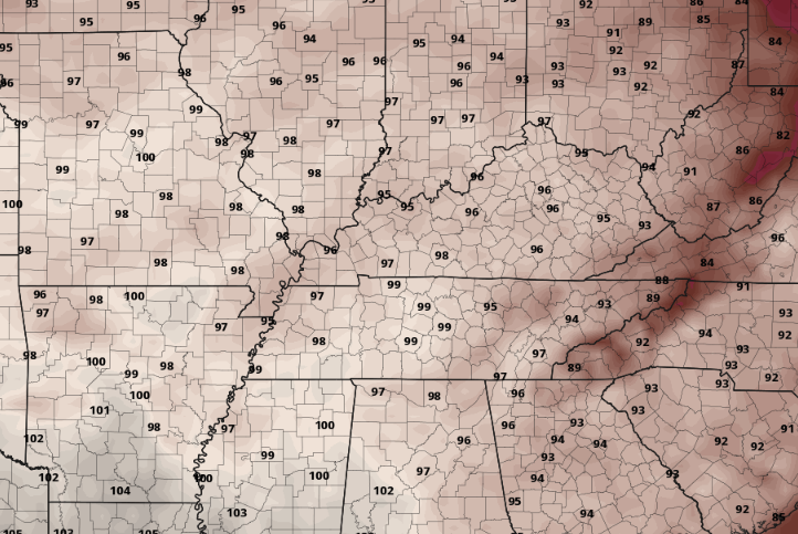
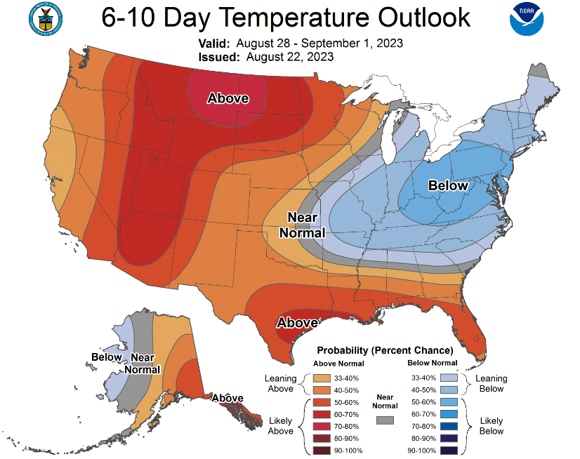
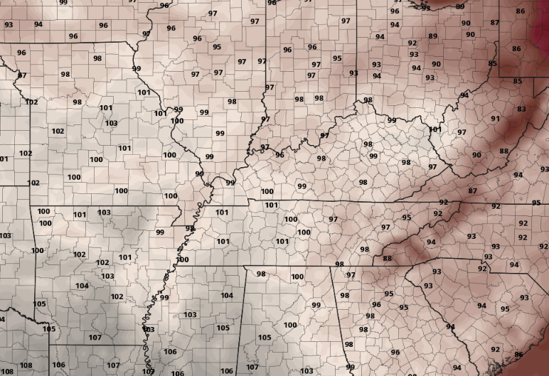
Good morning! Many are sitting (9 AM) in the low to mid 70s, with much warmer air to arrive into the afternoon. Starting first (below), our drought map is looking excellent. Other than a very small blotch of abnormally dry conditions across southern Middle Tennessee, the rest of the state is normal or exceeding normal (surplus of moisture). That being said, the outlooks moving forward, coupled with the dry week we have had thus far, could bring a turn to the area. This will be something worth monitoring, especially for agriculture folks or those who rely on water and/or dry surface conditions. The next hot topic, literally, are the temperatures moving forward. A weak cold front lies across a portion of the area today, but will do little to limit the heat. As such, highs in the lower 90s can be expected for most. Like today, Thursday will be a touch warmer. Values in the low to mid 90s can be expected with even warmer air Friday. That said, there is a catch on Friday high temperatures. Looking below, here is what some models think we could achieve (mid to upper 90s). Now the catch...a series of passing disturbances will bring the threat of isolated showers in the far north and east, with the bigger question on associated cloud cover. If these disturbances can maintain themselves a bit better south and east, associated cloud cover could limit highs from achieving mid to upper 90s for the day Friday. Likewise, if activity dissipates sooner or earlier in the day, hot - near record highs- will be possible. Extending the scope through the remainder of the month, relief is in sight. In fact, we will see a big change as early as Sunday. A passing cold front, bringing isolated to scattered shower/storm chances this weekend, will allow cooler air to filter in by late weekend (highs in the 80s). This will continue through the greater portion of next week, where the CPC suggests a dip to below average temperatures may even be possible. On the other side of the spectrum, below average rainfall remains in the outlook, again leading to the mentioned drought concerns moving forward. Heat safety should be priority number one today through Friday, as highs in the 90s combined with humidity will leave feel-like temperatures in the triple digits. In all likelihood, a heat advisory (most likely) to an excessive heat warning is possible both Thursday and more certainly on Friday. Drink plenty of fluids, wear light colored clothing if outdoors, and take frequent breaks.
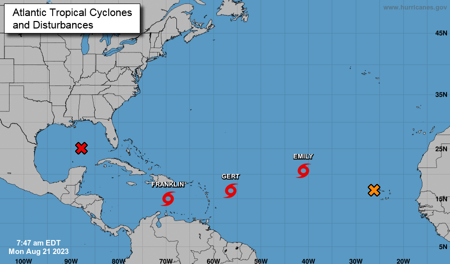
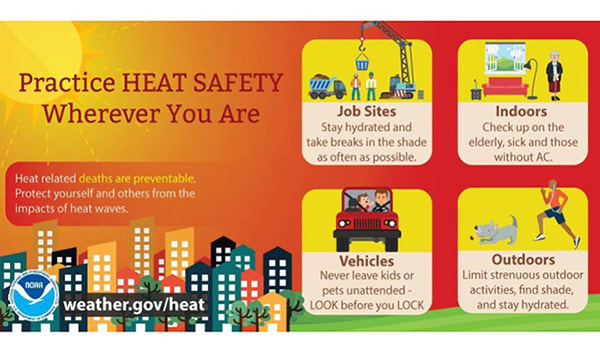
Starting first across the Tropics, check out the activity! Very active here late in the month thanks to the setup we have aloft. Three tropical storms are on going, with 2 more areas of likely development in the next 24 to 48 hours. The bad news is development into a tropical disturbance to storm is likely in the Gulf, bringing strong winds, flooding potential, and choppy seas to Gulf states- especially Texas where this system will track and make landfall in the next couple of days. The good news..elsewhere the 3 named storms will work north and eastward with little harm to the USA in the days to come. We will continue to keep a close eye on the Gulf along with any other threats to the states to come. The big news locally will be the intense heat. Highs today under mostly sunny to partly cloudy skies will find the lower 90s, with a gradual uptick in temps moving forward. By Thursday, highs are set to achieve values ranging from the mid to upper 90s. Combining the high heat with humidity, it is very likely heat indices will feel closer to the 105-110 degree range for some locations. At the very minimum I expect a heat advisory to be issued mid to late week, with a warning not out of the realm of possibilities. Keep your heat safety in mind through this week. Below are a few helpful tips to "beating the heat." Drink plenty of fluids, take breaks, find a way to cool off, and limit your outdoor exposure. Have a wonderful day, stay cool, and check back in for the latest on heat related products sent out by the National Weather Service in the days to come.
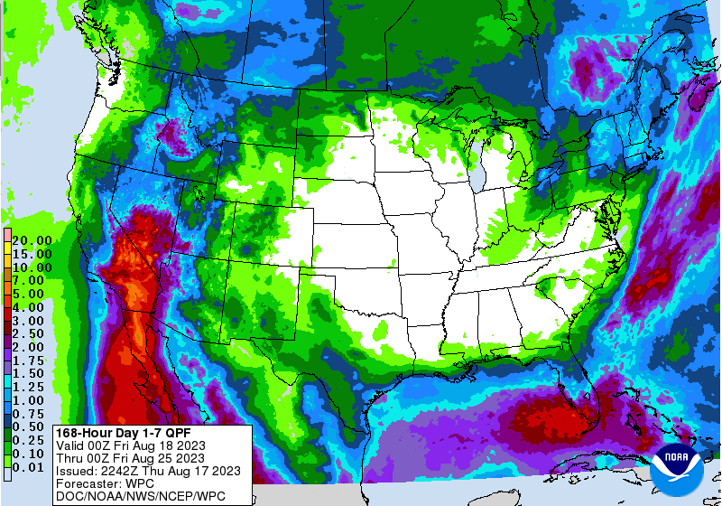
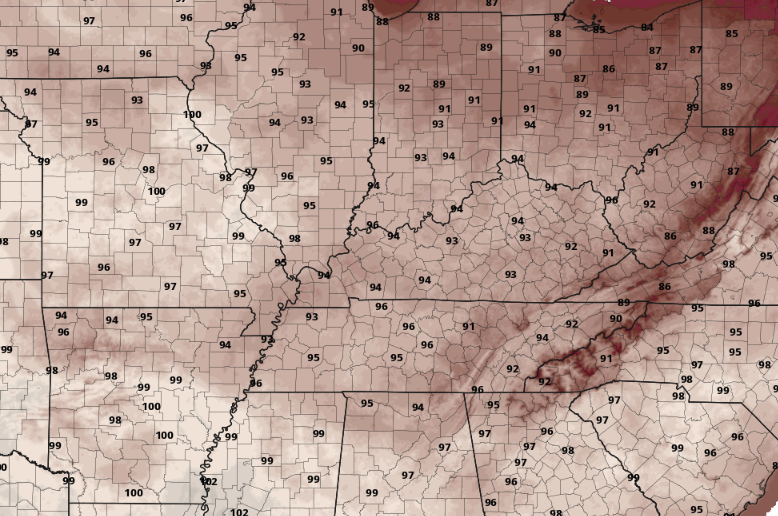
I hope your Friday is off to a good start! The forecast for today should bring you good news, as many top out in the low to mid 80s under mostly sunny skies. The trend moving forward is that of a dry and hot one. Looking below, this is the 7-day rainfall outlook (according to WPC) for the United States. As you can see, no meaningful rainfall is expected today through next Thursday, and this will be the case for much of the center of the U.S. So what kind of influence will this strong high pressure bring to East Tennessee? A late summer heatwave. Temperatures will feel wonderful today, but changes are quickly on the way. By Sunday, highs will range in the upper 80s to low 90s, followed by increasing values thereafter. Potential highs, visualized below, could warm into the low and mid 90s by Tuesday, with a few mid to upper 90s not impossible Wednesday and Thursday (especially for southern locations). To make matters worse, humidity will make things feel closer to the triple digits for many. Something we have fortunately not had to talk much about this year is the heat, but keep your heat safety in mind all of next week as this will likely be the warmest we have been this year to date. That will do it for today...get out and enjoy the beautiful weather planned through this evening. We will even start Saturday morning off with a fall-like feel with lows tonight in the upper 50s to near 60 degrees. A heatwave then sets up Sunday into next week.
|
Your trusted source for everything weather in East Tennessee.
Social Media
|

