|
Happy Friday to all! So far today, mostly cloudy skies have been the main story. For this afternoon and early Saturday, isolated showers/drizzle remains possible. The later half of the day Saturday we will begin clearing out for a beautiful Super-Bowl SUN-day. 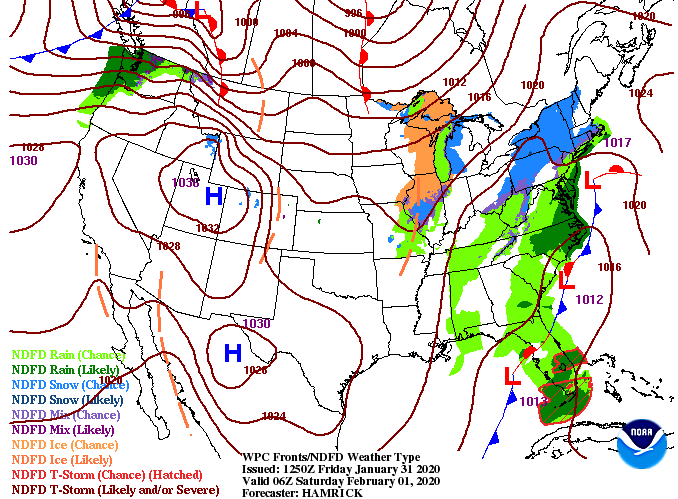 As depicted below, a few isolated showers remain possible today and early tomorrow before drier air works in. A high pressure system will build in the Gulf, allowing for warmer and drier air from the Southwest. Sunday high's will be in the mid to upper 50's with Monday in the lower 60's. As for Tuesday, showers return and continue into Wednesday as well. For Thursday, reinforcing moisture will bring the chance for heavier showers and storms before colder and drier air works in late next work week.  Taking a look at the totals for this mid-week system, we are in the ballpark of an inch. With 5 to 6 days out, totals will vary over the next couple of days but do expect a fair amount of moisture Tuesday through Thursday. 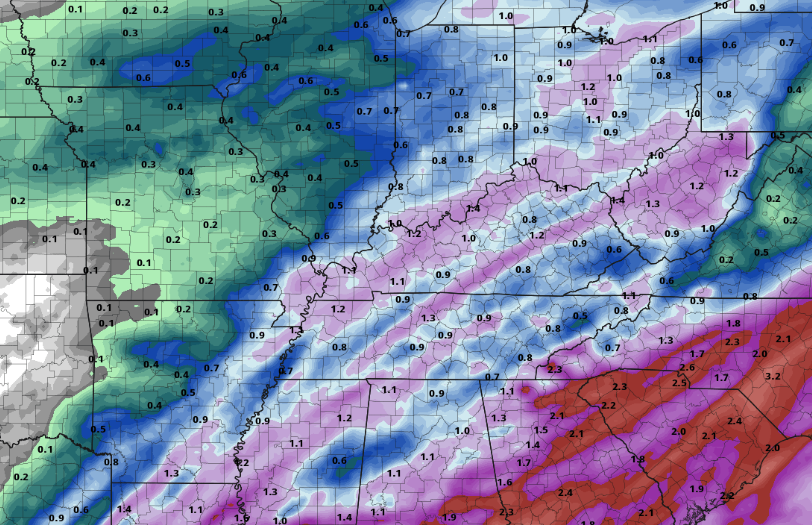 That will do it to close out the work week but I wish everyone a good and safe weekend. If you plan to do some exploring (especially Sunday), be sure to share your outdoor adventures with us via Twitter & Facebook.
0 Comments
Check out the latest view from Newfound Gap. As for here in the valley, satellite shows some breaks in the clouds beginning to work in. Temperatures in the mid 50's and rounds of sunshine are what you can expect today. 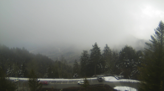 Looking ahead, scattered showers arrive tomorrow afternoon and into Saturday morning. By Saturday afternoon, clearing begins to take place setting up sunny skies and warm temperatures on Sunday. A high pressure system is expected to develop in the Gulf early this weekend, providing warm and dry southwestern air. By mid-week, rounds of showers and a few storms return.  Friday's forecast remains near average for most, as the Plateau will have high's in the upper 40's and the valley in the low 50's. Warmer air will arrive (nearly 10 degrees warmer) by Sunday and Monday of this next week. 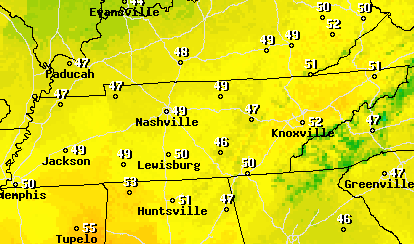 That will do it for today's forecast, but be sure to sign up for this year's almanac, if you haven't already. Today is the FINAL day to subscribe and/or submit content. You can access the page by visiting SecretCityWeather.com/Almanac. Good afternoon! So far today we have stayed pretty dry with just an isolated shower for the plateau this morning. As we continue into the afternoon, these isolated showers remain possible, but overall we will stay mostly cloudy. Looking at the graphic below, this system looks a little more intimidating than what it actually is with a few isolated showers working through this afternoon and evening. For Thursday, we will have a brief break with afternoon sunshine and slightly warmer temperatures. 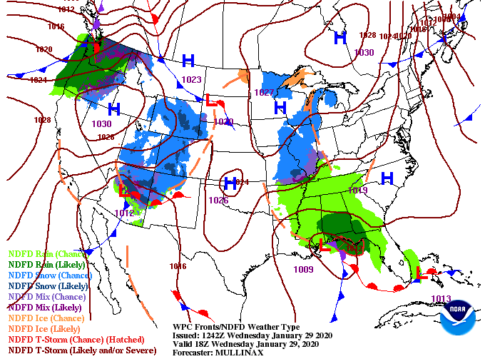 A few isolated showers are possible this afternoon and evening but as we get into Thursday, drier air works in. This will leave the chance for rounds of sunshine during the day but clouds once again build overnight tomorrow. For Friday, scattered showers return for the afternoon and continue into Saturday morning. Once the last of the remnant showers works out Saturday afternoon, much drier and warmer air works in for Sunday. High's in the upper 50's and mostly sunny skies are finally back in the forecast to end the weekend.  Looking at temperatures for tomorrow, model guidance is suggesting the lower 50's as high's. With some rounds of sunshine likely, temperatures could warm to be near the mid 50's by the afternoon. Nonetheless, above average temperatures and dry conditions are what you can expect for tomorrow. 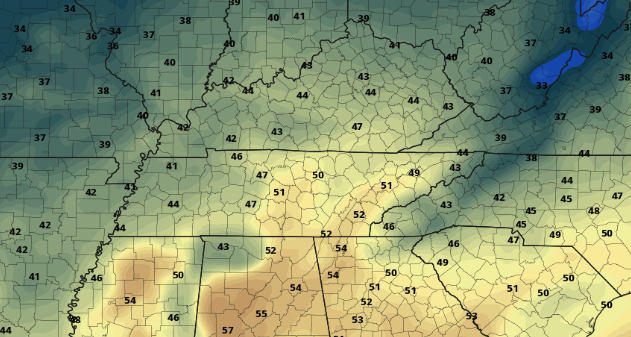 That wraps it up for today, but don't be surprised if a brief shower passes through this afternoon; drier conditions return tomorrow. Good afternoon! Plenty of sunshine is expected this afternoon as low level clouds continue to fade out. Unfortunately, clouds will work back in this evening as rain chances are possible tomorrow. For temperatures today, we will have high's back in the upper 40's and lower 50's. 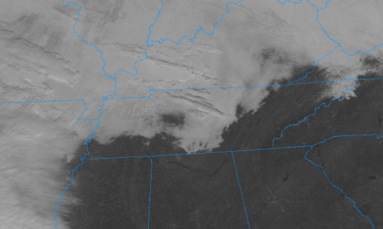 Looking at model guidance, scattered showers will work in tomorrow morning and continue throughout the day. The good news is there is not a ton of moisture supporting this system so showers will be light and scattered. Thursday and much of Friday we will dry back out with some rounds of sunshine in the afternoon. For Friday night, shower chances return before drier air and sunshine arrive Sunday and early next week.  If you are a fan of warmer temperatures, you are in luck! As suggested by the CPC, the first week of February will be on the warmer side with high's Sunday and early next week in the upper 50's to lower 60's. A blast of cold air returns mid to late next week so enjoy these above average temperatures while they last. 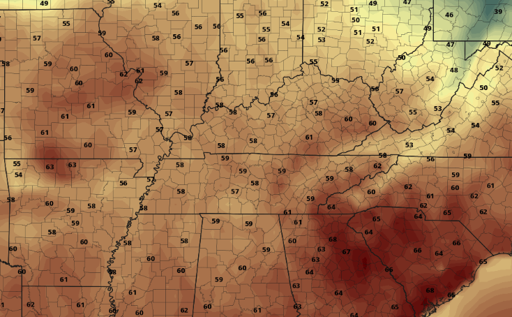 It wouldn't hurt to pack an umbrella tomorrow just in case you do come across a few showers, but overall, we will stay mostly cloudy. For more details into this week's forecast, watch our video below and check the day to day forecast under "Weekly Forecast" (Above). Showers have continued to push east and are sitting in the eastern half of the valley and into the higher elevations. With this being the last of the showers for the day, drier air will work in this evening. 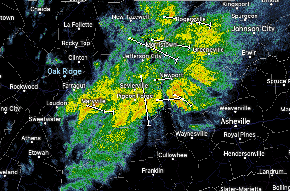 Looking at the latest satellite, clearing is beginning to take place for western and middle TN. We will more than likely see some peaks of sunshine this afternoon with more opportunity tomorrow. As for temperatures this week, expect to stay average with high's in the upper 40's each day. 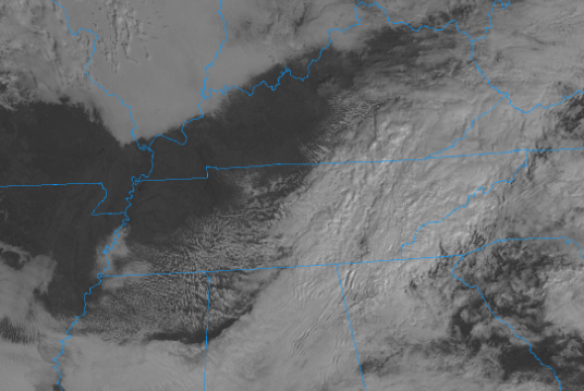 Comparing model guidance to the current satellite, we do see clearing continue from west to east. Much needed sunshine will make a few appearances this afternoon with high's near 50. Tuesday will be mostly dry with partly cloudy skies but shower chances return Wednesday. Earlier models had this system staying more to the south but the latest data has this track further north. Regardless, scattered showers are likely Wednesday, with snow showers possible in the higher elevations overnight.  The latest from the CPC shows next week (the first week of February) to likely be a bit warmer than average. We'll likely see temperatures in the 50's much of next week. Another round of cooler air is favorable as we get into mid-February but snow chances remain grim here in the valley. 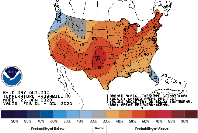 All and all, it looks to be a fairly average this week with rain chances every other day and temperatures in the upper 40's. Be sure, if you haven't already, to subscribe to this year's almanac at SecretCityWeather.com/almanac I hope you are staying dry out there! The good news is the last line of moderate to heavy showers is working through now, leaving only isolated chances this afternoon and evening. 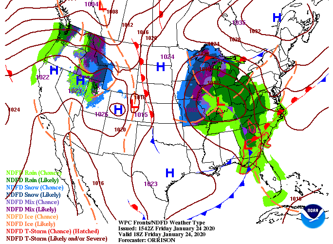 With the center point of the low pressure system so close, we will likely see wrap around moisture into Saturday morning. The moisture will likely be in the form of snow flurries but isolated showers are possible for the valley (depending on temperatures). We will begin drying Saturday afternoon and Sunday before another round of light scattered showers/flurries arrives Sunday night and Monday morning. By the afternoon, rain will have moved out leaving drier air and warmer temperatures mid-week.  If you have any plans for Saturday, be sure to bundle up. We will start the morning in the mid 30's with afternoon high's only increasing into the lower 40's. Outside of isolated showers/snow flurries in the morning hours, expect a mostly dry and chilly day.  That's all we have to cap off the work week, so I hope you have a wonderful weekend! Remember to subscribe to this year's FREE East Tennessee Almanac at SecretCityWeather.com/Almanac. Taking a look at the latest shot from the Newfound Gap area, mostly cloudy skies and mild temperatures (low 40's) are what you can expect for the lunch time hour. Moving into this evening, showers will begin working in arriving by the overnight hours and through Friday. 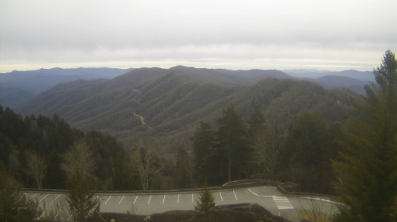 The latest radar scan (as of noon) has showers around the Chattanooga area and moving northeast around 20 mph. Expect these to arrive by the evening hours tonight and continuing through the day Friday. Because areas of low pressure spin counter-clockwise, we will see wrap around moisture into Saturday. For the morning hours, this will likely be in the form of snow showers/flurries, but into the afternoon, all rain. No accumulation is expected but the sight of some snow will be nice given the cold air we have had to deal with. 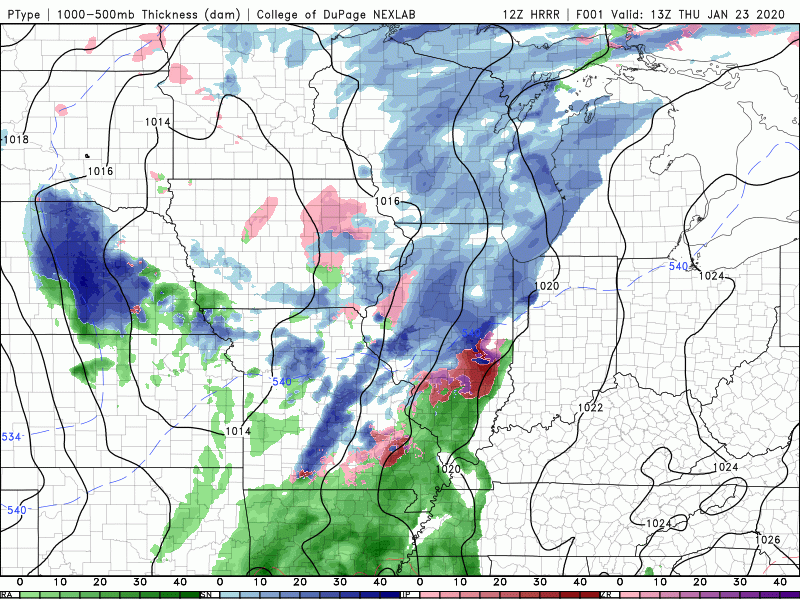 The latest data continues to show upwards of an inch of rain through Saturday with locally higher amounts possible. Be sure to account for breezy conditions Friday night and Saturday as wind chills could be in the low 30's Saturday morning. 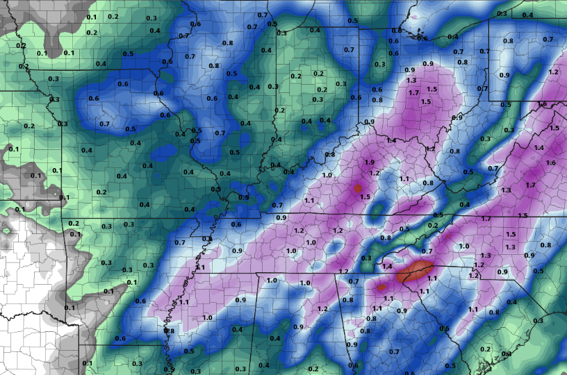 That wraps up today's forecast so stay dry and warm as we close out the work week. For daily high's and low's, visit the "Weekly Forecast" tab at the top of the page. We started the morning very cold; the coldest of this year in fact. The good news is a warming trend is set to begin with temperatures staying near average this week and slightly above average next week. As for right now, a system to the west will continue to push in cloud cover throughout the day today and tomorrow. 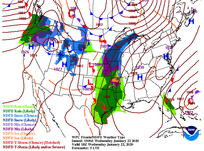 By tomorrow evening and overnight, showers will arrive and carry on throughout the day Friday. Rain totals continue to be upwards of an inch here in the valley with locally higher amounts possible. Getting into Friday night and Saturday morning, we will likely see a transition to frozen matter (snow) take place. Though no accumulation is expected here in the valley, there could be minor accumulations in the higher elevations. As we get closer to time we will have a more realistic idea. Nonetheless, it will be nice to enjoy a few flakes with this very cold air that has been hanging around. 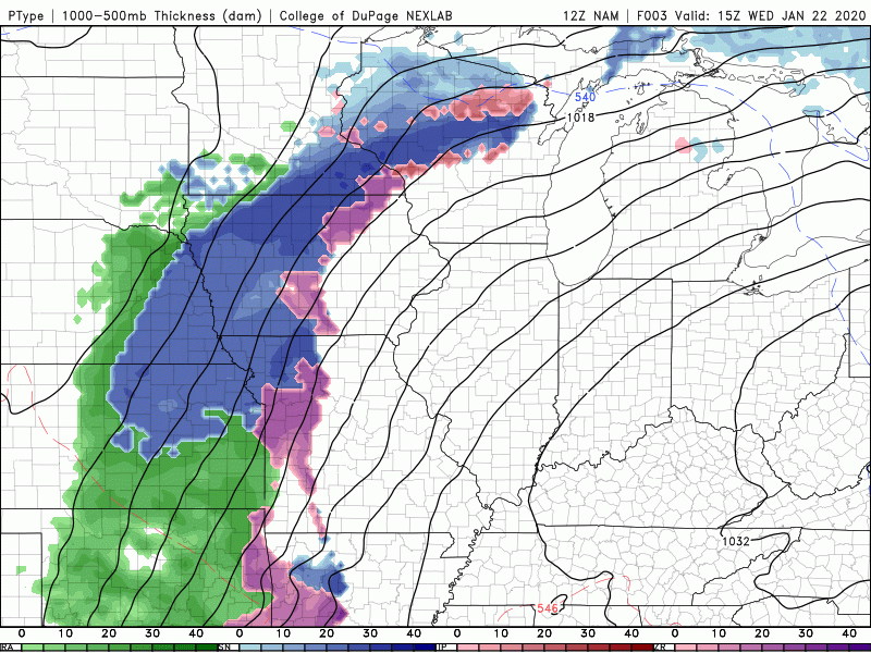 Looking longer term into the end of January, this warming trend is expected to continue. The CPC (Climate Prediction Center) gives east Tennessee a good chance of slightly above average temperatures to close out the month. Don't let this fool you though, rounds of colder air are likely to return as we get into February. 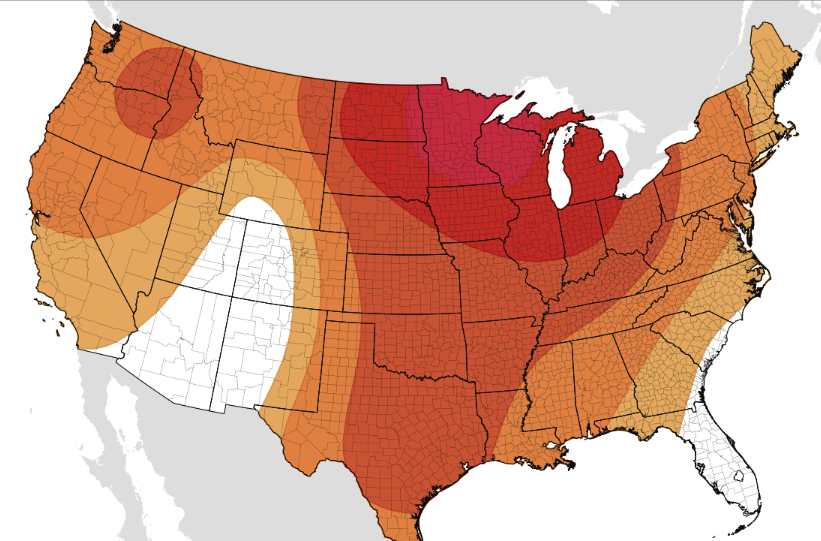 Remember to sign up for this year's addition of the East Tennessee Almanac. If you would like to submit photos taken in 2019 (for consideration in this year's Almanac) you may also do that at SecretCityWeather.com/almanac Good afternoon! Cold air sticks around today with lunch time temperatures around freezing for much of the valley. I have better news for Wednesday, though, as ridging works in. 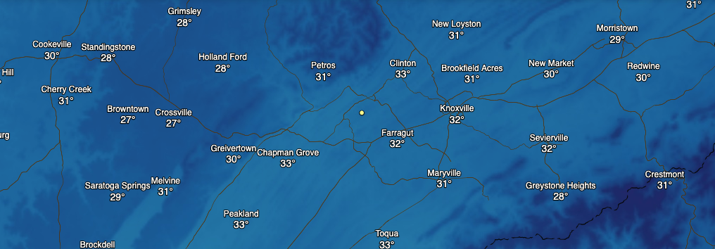 Looking at the latest 500mb heights and winds (half way through the atmosphere), strong ridging is working in, providing some much needed warmer temperatures and sunny skies. Unfortunately, this won't last long as rain is back in the forecast late Thursday and Friday. 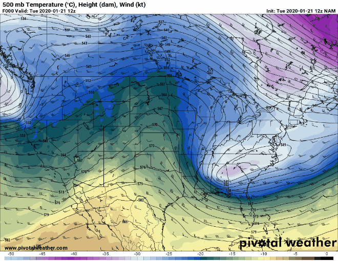 As seen from the chart above, ridging will play a big role in keeping things seasonable Wednesday and early Thursday. As we get into early Friday, showers move in from the west. Snow is seen on the leading edge of this system but by the time it arrives in east TN, we will see all rain. Early models show amounts up to an inch through Saturday, but as this system evolves we will have a better idea on totals. For the time being, enjoy sunny skies and slowly warming temperatures. 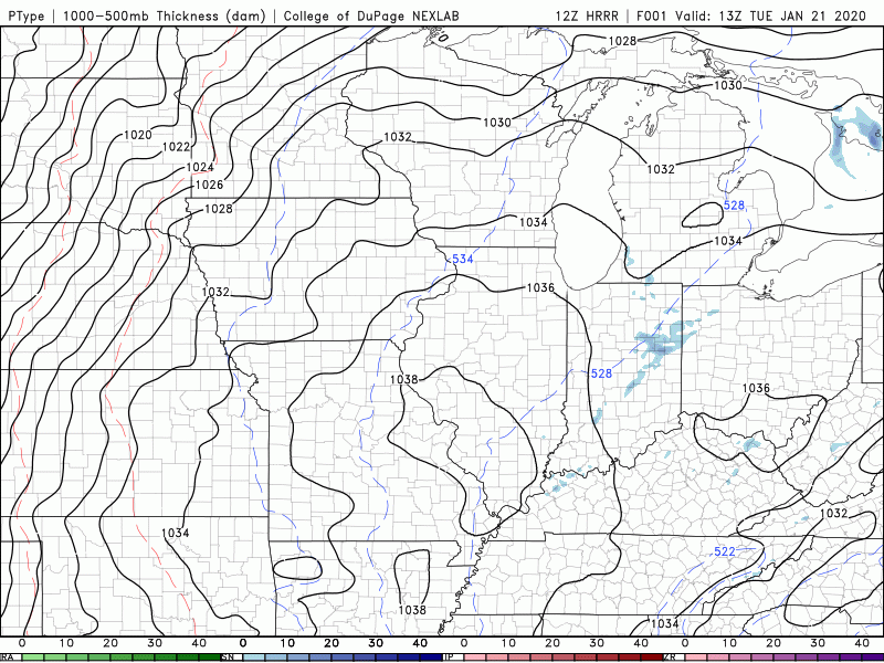 With clear skies overnight, temperatures will be very cold to start the day Wednesday. Looking below, bus stop and morning commute temperatures will be in the low 20's, so dress warm and in layers. We will eventually warm up to average high's for this time of the year (in the upper 40's). 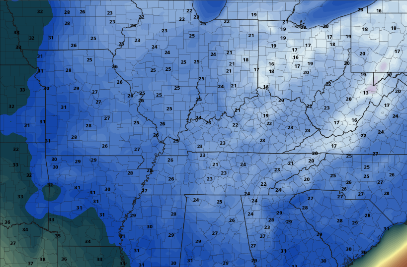 If you can endure another day of below average high's today, warmer air is on the way for Wednesday. Good afternoon and I hope you are staying warm out there! Lunch time temperatures today will be in the upper 20's for the valley and low to mid 20's in the higher elevations. To round out the day itself, expect mostly sunny skies with high's in the mid 30's. 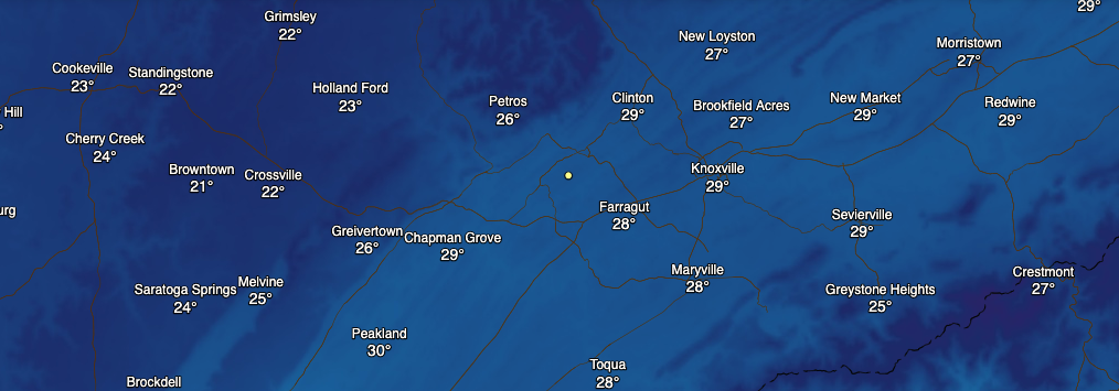 If we take a look at what's going on across the US, a major ridge is dominating much of the eastern half of the US. This ridging will keep things dry for much of the work week before showers move in late Thursday and into Friday. Along with the lack of moisture, temperatures will begin slowly warming with high's back in the 50's Thursday and Friday. 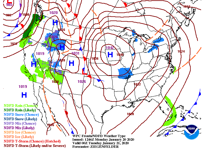 If you have been outside today, you may have noticed some snow flurries moving through. The latest sounding data shows some moisture in the "snow growth layer" of the atmosphere, contributing to the light snow showers/flurries we are seeing. Though no accumulation is expected, it is nice to see a few flakes with this cold weather. Moving forward, expect to stay dry for much of the work week with showers moving in late Thursday and into the day Friday.  That will wrap it up for today's forecast but be sure to dress warm the next couple of days. |