|
We have started with a wet morning as moderate showers push eastward. These will become more scattered by the early afternoon hours, before clearing begins overnight. A cold front, currently in Western Tennessee, will provide much cooler air the second half of today. Highs are expected to come mid-morning in the mid 60's before cooling temps follow the second half of the day. 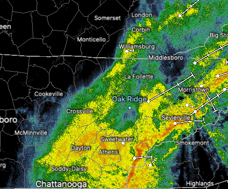 Looking at a model run of the cold front moving through, you can see how abnormal this is. Temperatures on either side of the front waver 20 degrees + from each other. Much cooler air sticks around for Thursday as highs will be in the mid to upper 40's. Some areas will be lucky to break the upper 30's. 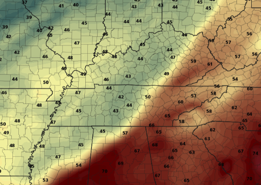 Once the moisture from today works through, a much needed dry stent will take hold. A large area of high pressure will dominate nearly all of the USA, leaving dry conditions into Easter weekend. The warming and dry conditions continue into early next week as well. 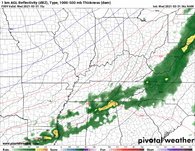 In addition to the rain we see during the day today, snow could also be in the mix. This will be confined to the highest of elevations, of course, but it's not too common to see or hear of snow across Tennessee in April. Valley locations could see a flake or two, especially into tomorrow morning, but nothing will stick. However, the highest peaks of the Smokies could see several inches. Looking at the "worst-case scenario", totals between 8-12" can be seen across the Tennessee/NC border. Blue values indicate 1-2". Again, this is the worst-case scenario, so most will likely see a few flakes fly without anything sticking (for areas like the plateau). High-resolution short term guidance suggests chance to see light lake-effect snow off of Lake Michigan as the flow is northerly tomorrow. This could lead to a few bouts of afternoon flurries across Eastern Kentucky and Tennessee. 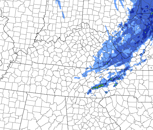 A BIG cool down will take place tomorrow with temperatures ranging 15-20 degrees below average. Fortunately, this is only temporary as high temperatures gradually warm Friday and through the weekend. Easter should be sunny and comfortable with highs around 70 degrees. Pre-recorded for 5pm show
0 Comments
Another bout of moderate rain is in the forecast late tonight and through much of Wednesday. Typically this wouldn't be too much of a concern but with the heavy rainfall we received over the weekend, a marginal risk for flash flooding is in place. Isolated flash flooding will be possible, specifically for those in low-lying and flood prone areas. 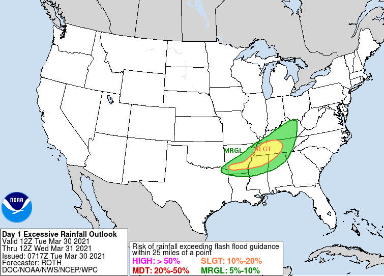 Analyzing model guidance, scattered showers arrive late tonight and become widespread throughout Wednesday. By Wednesday night, clearing will persist allowing for overnight lows around freezing. Some locations will even see mid to upper 20's overnight. The Smokies will have an opportunity for a light snowfall Wednesday night, as model guidance is hinting at upwards of an inch for the highest peaks. Into Thursday, high's for most will stay in the 40's and overnight lows will be in the teens and 20's.  Looking at the progression of the cold front tomorrow, it is clear to see the temperatures gradient between Middle and Eastern Tennessee. A 20 degree swing can be seen across the state as a powerful late-winter like system works through. Fortunately, dry conditions will prevail Thursday onward with warming temperatures as well. 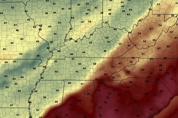 Look for showers to lead to isolated flash flooding through tomorrow. Following, a cold air mass will take hold for Wednesday night through Friday before a gorgeous Easter weekend finds us. Pre-recorded for 5pm show
After an eventful weekend, here are the unofficial rain totals from the NWS. Significant rain fell across the Plateau with some locations near Oneida with well over half a foot recorded. This led to numerous flash flood warnings and advisories through the weekend and even into the day today. 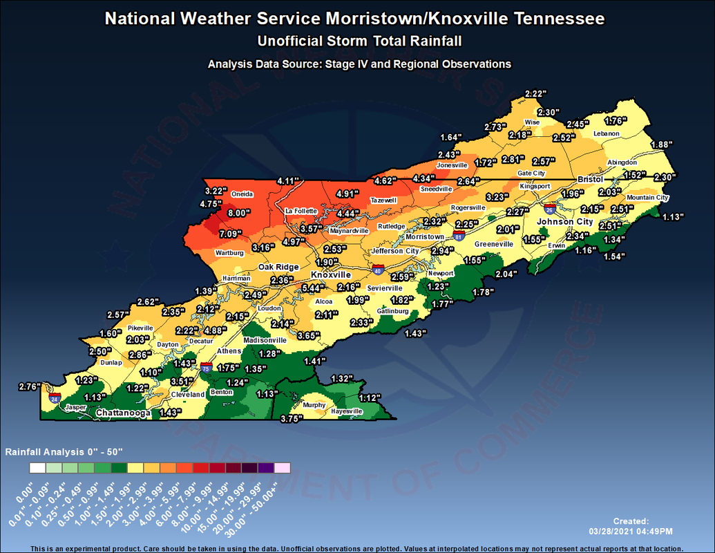 Working ahead, another system will bring moderate rainfall (at times) Tuesday night and Wednesday. This could lead to additional flash flooding & flooding across the region, given the saturated soils we already have. Fortunately, our two-day dry spell with lots of sunshine should assist in lessoning those odds. Nonetheless, the WPC has placed East Tennessee under a Marginal risk for flash flooding on Wednesday. Conditions clear and COOL back out Thursday through the weekend.  Short-term a cold spell is set to return later in the week. Our next weather maker will have a trailing cold front looking to knock high temperatures into the mid 40's for most. Overnight low's will be in the 20's and 30's Wednesday to the weekend. This is a heads up now to protect & cover any plants you may have for the new growing season. Longer term, April looks to be a warm and dry one. The latest from the CPC suggests above average temperatures and less than average rainfall through the middle of the month.  That will wrap it up for the day....Don't be surprised to see high's Thursday and Friday nearly 20 degrees below average. A strong front will slide through bringing less than ideal temperatures for this time of the year. More information can be found on our daily video forecast below. Pre-recorded for 5pm show
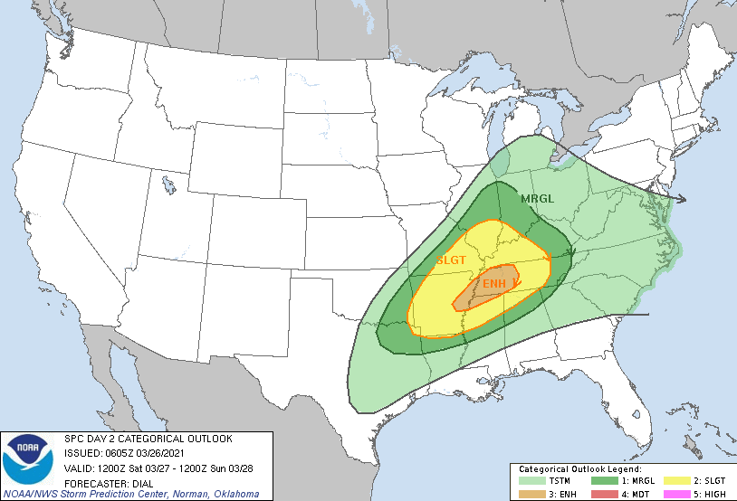
A much needed pleasant end to the work week is upon us with plentiful sunshine and mild temperatures. Comparing the current temps to this time yesterday, the western 2/3's of the state are a bit cooler with the passage of a cold front.  Pushing into the weekend, another round of strong to severe storms is possible. The timing falls Saturday evening/night and into early Sunday. The Day 2 SPC outlook has an enhanced notch for Western TN with the Day 3 putting in East TN. This is because of the day transition from the system arriving Saturday night into Sunday. Regardless, the biggest threat will be straight line/damaging winds. With the heavy rainfall picked up last night and again expected this weekend, downed trees and power lines will be something to look out for. Hail and isolated, short-lived, tornadoes can't be entirely ruled out either.
Flash flooding will be another hazard to look for. With several inches of rainfall picked up yesterday, another round could allow for water levels to rise quickly. A slight risk encompasses much of the state Saturday into Sunday. 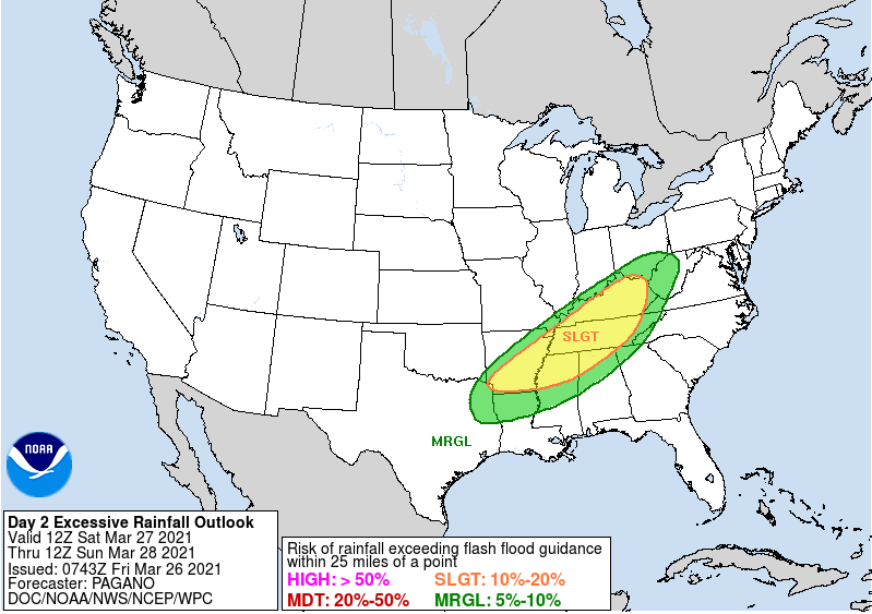 Model guidance breaks down with dry conditions through Saturday morning before scattered showers arrive late morning to early afternoon. This will be followed with a line of storms working west to east. Repeating, the greatest threat will be damaging winds and flash flooding. Showers continue into the first half of Sunday before we dry back out Sunday night and Monday. Isolated to scattered daytime showers will then follow towards mid-week. Temperatures, overall, will trend at to slightly above average.  I hope everyone has a great weekend, stay safe and weather aware! We'll provide updates via Twitter & Facebook through the weekend. Pre-recorded for 5pm show
Diving right into it, reports of closed roads and flooding conditions are coming in around Hamilton county as storms continue to pound southeastern Tennessee. The SPC outlook for today has upgraded the region to bring Oak Ridge and west to an Enhanced risk of severe storms. Chattanooga remains under a moderate (4/5) risk through tonight. Damaging winds will be the greatest threat (60mph and greater) but 1" or greater hail, and isolated strong tornadoes (especially I-75 and west) are all possible. 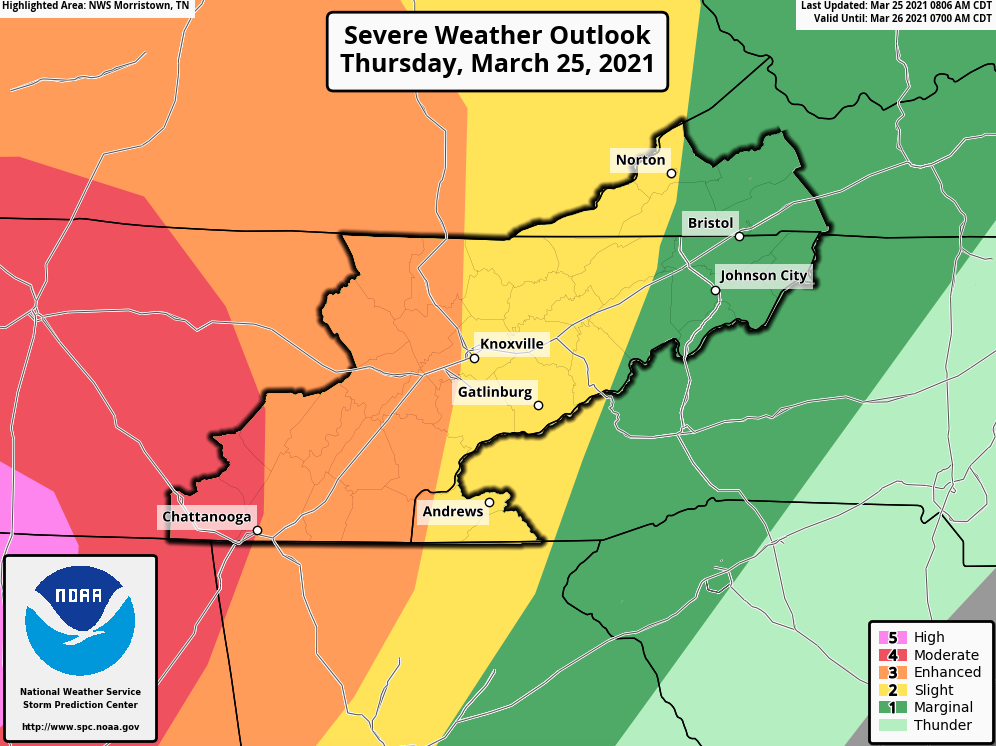 In addition to the high potential for severe weather across parts of the state today, flash flooding also poses a moderate (20-50%) risk. Chattanooga and southeast TN are under a moderate risk, while the remainder of the region lies under a slight (10-20%) risk. Flash flooding reports are already coming in and will continue through the overnight and morning hours of Friday. TURN AROUND, DON'T DROWN. 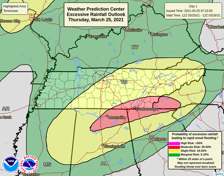 High-resolution short-term model guidance depicts rainfall totals as high as 6+ inches across Hamilton county before the day ends. This is a substantial amount of rain within a 12 to 16 hour period, so anticipate flash flood warnings throughout the area overnight. 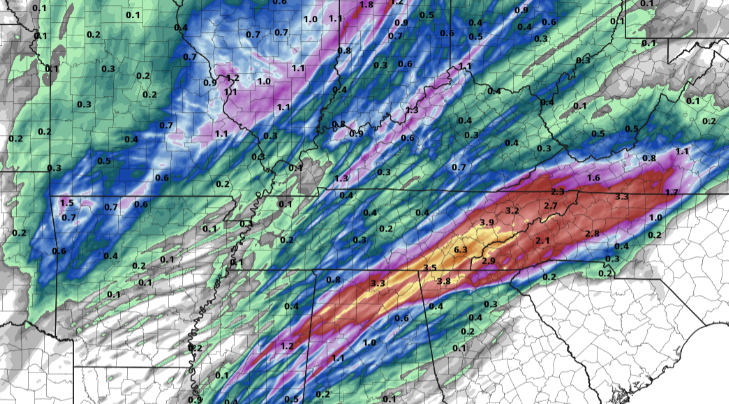 Breaking down future radar, heavy showers and storms will continue this afternoon with a bit of a lull for middle Tennessee over the next few hours. A cold front will then bring strong to severe storms (from west to east) this evening and overnight. The "prime" time period we'll be watching is from 10pm to 2am. Storms will likely impact Middle TN and Northern Alabama the hardest. A tornado WATCH (meaning the environment is favorable for tornadoes through the afternoon) has been issued for much of Alabama, Mississippi, and southern Middle Tennessee through 9pm (8pm CDT) tonight. 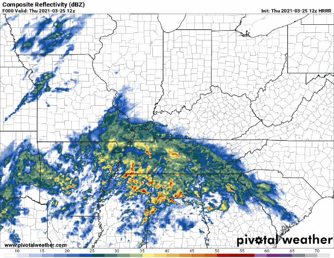 PLEASE adhere to watches and warnings this afternoon/evening/night. The biggest threat remains damaging winds and flooding but as the cold front draws in tonight, large hail and tornadoes will be possible. This is especially so for counties west of I-75. Use caution, remain weather aware, and know your plan if severe weather strikes your location. We'll continue to provide updates on Twitter and Facebook, but don't forget to check out our video forecast below. Lots of additional details included. Pre-recorded for 5pm show
A low is currently developing and enhancing along northern Texas and Oklahoma this afternoon. It is expected to work north and eastward, bringing strong and severe storms to parts of Alabama, Mississippi, and Tennessee tomorrow.  The latest SPC Day 2 outlook encompasses Chattanooga in the Enhanced (3/5) risk, while the remainder of East Tennessee sits under the Slight (2/5) risk. Strong storms will bring the opportunity of damaging winds (15% chance) and severe hail (1-inch or large at a 5% chance). We again have nightfall on our side to help, as storms will slowly weaken eastward towards the end of the day. 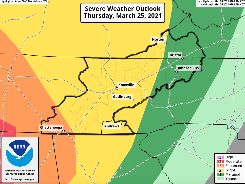 Along with severe weather, flash flooding also remains a hazard. The western half of East Tennessee sits under a slight (10-20% chance) for flash flooding through the day tomorrow. Rainfall accumulations will generally range between 1 and 3 inches but locally higher amounts are possible under training heavy storms (mainly across Middle TN). 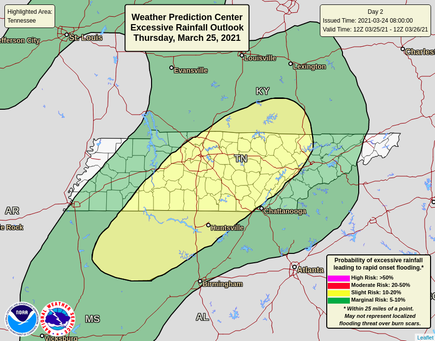 Looking at future radar, widespread moderate showers will start the day tomorrow. By the late morning to early afternoon, they will become more scattered. This will be the time period that will really judge and set up the later strong to severe "stuff". A few ingredients to look for that could enhance the severe odds include high dew points, sunshine, and limited storms through the early afternoon. Timing for the line ahead of the cold front comes between 8pm and 2am. There is still uncertainty on how quick the low & front move through the day tomorrow. Overall, be on alert through the afternoon, evening, and overnight hours. The biggest threats are damaging winds, hail, lightning, but isolated tornadoes remain possible.  Be sure to have all your severe weather plans ready. These include a save place to hide if a tornado warning were to be issued, spare batteries, food, water, flashlights if power were to go out, and a way to receive watches and warnings if they were to be issued. The worst weather will be under the red "bullseye" but severe storms can't be ruled out through the later half of the day tomorrow for our neck of the woods. Pre-recorded for 5pm show
Another bout of severe weather is on our radar this week as a low will develop to our south and work north and east. The latest Day 3 (Thursday) release from the SPC has parts of East Tennessee under a slight risk for severe storms. We will keep a close eye on the expansion of this as the parameters look favorable for strong storms across the Southeast. 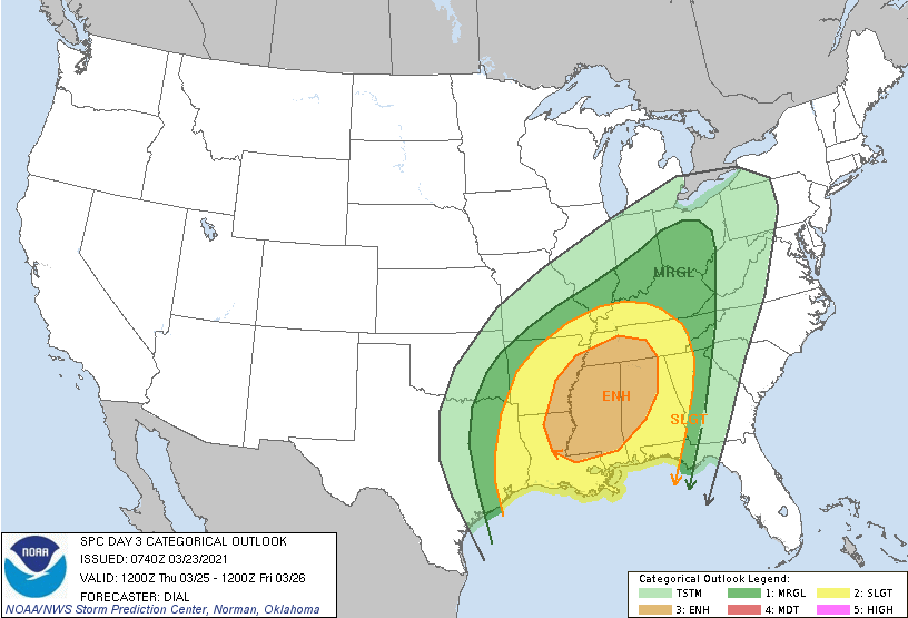 Breaking this down a bit further, a low working through the plains will bring limited chances for rain late tonight and through Wednesday. As this works northward, a secondary low is expected to develop and work north and east. This secondary one is what we'll watch closely. Initial showers will arrive Thursday morning but strong to severe storms will arrive in the late afternoon and evening. All forms of severe weather are on the table: Damaging winds, hail, and (for now) isolated spin-up. Again, I would check back in as we could see severe risks expanded from the SPC this afternoon and ahead. 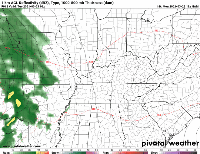 In addition to the NWS defined severe weather, flash flooding will also be a concern. As heavy showers and storms set up through Thursday, water levels can quickly rise. Looking at one of many model runs, the axes of heavy rain will be across northern Alabama and central Tennessee. Watch for a shift in this line as there is still quite a bit of uncertainty with where this will set up. 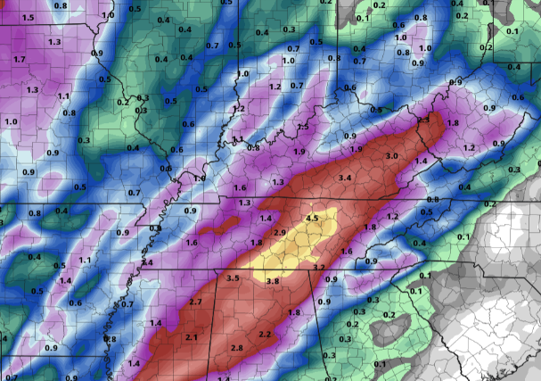 Cloud cover will dominate much of today but we should stay dry through this evening. A few isolated showers find us tomorrow but heavy showers and storms follow for Thursday. Continue to check back in for updates & practice your severe weather plan ahead of time. Pre-recorded for 5pm show
Sunshine and warm temperatures find East Tennessee again today with high's topping out around 70 degrees. Unfortunately, cloud cover and eventual rainfall also find their way back Wednesday and Thursday. Looking at the current surface map, low pressure is working through the Central plains, bringing severe weather opportunities to northern Texas. As this shifts east, scattered rain finds us Wednesday with better chances on Thursday.  Breaking model guidance down, we stay dry now through Tuesday evening. Scattered showers will accompany the low to our (current) west. The better weather maker arrives late Wednesday into Thursday, bringing heavy showers and storms for the day. As of now, the SPC has issued a 15% chance for severe weather along Alabama, Mississippi, and Louisiana. Given the latest data, I could see them expand this area as we get closer to Thursday. For now, anticipate showers (heavy at times), lightning, and the chance for gusty winds & hail (sub-severe).  Enjoy another mild and sunny day before cloud cover works into overnight and throughout Tuesday. Showers then follow for Wednesday and Thursday with bettering conditions Friday and the weekend. Pre-recorded for 5pm show
Cloud cover continues to persist here at the noon time hour, but clearing is on the way. Just to our west, sunshine is gleaming for northwestern Tennessee. With the overcast skies and passing of a cold front, temperatures are much cooler this afternoon. As seen below, temperatures were anywhere from 10-20 degrees warmer this time yesterday. The good news is warmer air returns this weekend.  In fact, if we compare the average temperature to what is expected this weekend, we'll be 5-10 degrees above the norm. Sunday afternoon high's will range from the mid 60's to the low 70's with plenty of sunshine overhead. 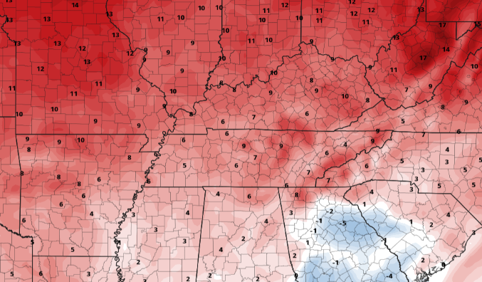 We finally transition back to a much quieter and less active pattern. Conditions stay dry and warm Saturday through Monday before showers edge back in Tuesday. Our next weather maker doesn't look super impressive, but most will likely see scattered showers Tuesday and midweek. Temperatures will fair above average Saturday through Wednesday.  That will do it for today. The next several days will tick upward in temps with plenty of sunshine to go around. Enjoy and have a great weekend! Pre-recorded for 5pm show
Scattered showers are beginning to fill back in this afternoon. Some of these could be strong bringing heavy rain, lightning, and small hail (as is the case for the cell across Oakdale & Oliver Springs). Temperatures are nearing the high's for the day around 70 degrees but cooler air is in the forecast for tomorrow. 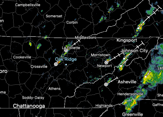 Timestamp 1:20 PM Moving forward, scattered showers will continue to disturb the day before drier air arrives Friday morning. Gradual clearing can be expected for tomorrow with lots of sunshine in for the weekend. Temperatures will tick down Friday (in the mid 50's) but will quickly rebound with high's in the 60's throughout the weekend. High pressure will dominate much of the eastern half of the US, giving way to plenty of sunshine. 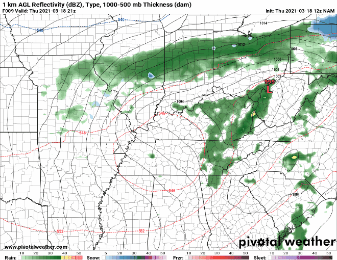 Another round of scattered showers can be anticipated this afternoon and evening as the low shifts east. Gusty winds will continue until the cold front passes through, where cooler air arrives for Friday. Following, a picture perfect weekend is ahead! Pre-recorded for 5pm show
|