|
Gorgeous day in the works! The passing cold front has allowed for both cooler and less humid air today. Highs will warm a few more degrees to top out in the mid 80s, while overnight lows bottom out in the upper 50s to low 60s. Yes, finally a taste of Fall in some aspects. Moving forward, warmer temperatures return, with highs Friday around 90 degrees. Showers and storms (isolated to scattered) also return- mainly through the weekend. 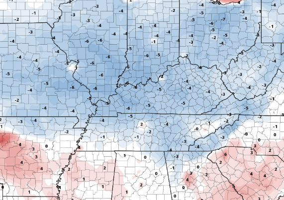 The Tropics are ramping up! Three different disturbances are of concern, with two in particular worth keeping an eye on. The two off the coast of Africa and near the Caribbean could bring impacts, as they have a 40-60% chance of development over the next two days. It seems the second half of hurricane season will be a very active one. 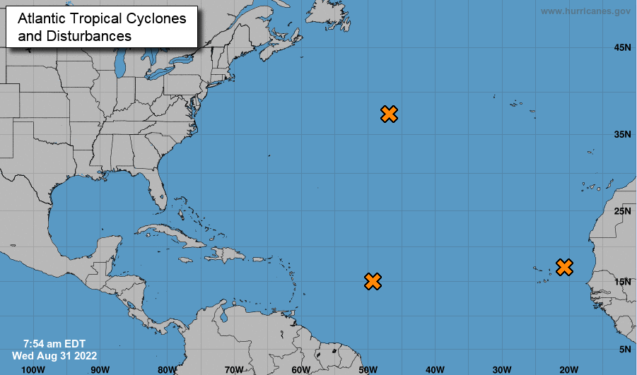 Be sure to enjoy the great conditions and fall feel to start Thursday morning. Warmer temperatures once again return in the days ahead, with low chance shower/storm potential Saturday, Sunday, and into early next week. Pre-recorded for 5pm weather broadcast
0 Comments
Pretty lame so far this morning, with little more than a few light showers and sprinkles for the valley. With that said, heavy showers are across the northeast, with activity picking up into the foothills and Smokies. This will be the case through this afternoon, before drier air finds us tonight. 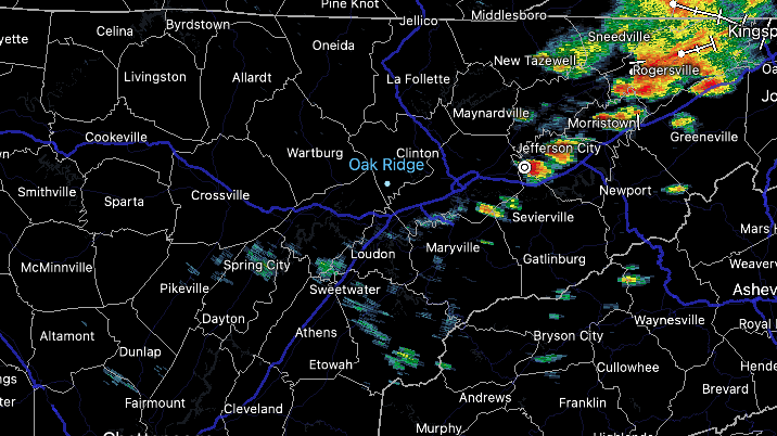 Looking at the temperature differences from this time yesterday, you can clearly make out the cold front. Kentucky, West/Middle TN, and north are all 10+ degrees cooler. We will feel the relief tonight, as lows bottom out in the mid 60s. Humidity will be much lower tomorrow as well, making afternoon highs feel very pleasant (topping out in the mid 80s).  Moving forward, a gradual warming trend will find us through the end of the work week, with highs by Friday around 90 degrees. Showers and storms also return (isolated to scattered in nature), continuing through the weekend. These will be best during the afternoon to evening hours each day (typical summer time activity). Pre-recorded for 5pm weather broadcast
Warm and humid again today, with highs topping out in the upper 80s and low 90s. A few isolated showers/storms can't be ruled out this afternoon (mainly across Plateau and elevated locations) otherwise mostly dry for many. Working into tonight, cloud cover increases as a cold front approaches the area. A few showers/storms will be possible late, with activity increasing throughout the day tomorrow. Our best chances will be early to late afternoon Tuesday, with a few stronger storms not ruled out (but very low chances for severe). By Wednesday, high pressure fills back in with warming temperatures and mostly sunny skies the remainder of the work week.  Additionally, a few isolated instances of flash flooding will be possible, but again, low chances overall. As you can see below, nearly all of East Tennessee is within the marginal (5%) chance. Given the "pop up" activity we have seen in days past, some locations will be more susceptible to higher running water than others. Overall though, we are looking at an area-wide quarter to half an inch rainfall, before clear and dry conditions return. 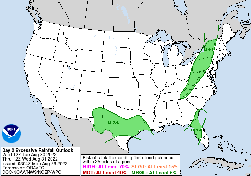 The best of the week will likely come Wednesday, as highs top out near average and humidity is much lower. This will gradually trend upwards in the days to follow so take advantage! Pre-recorded for 5pm weather broadcast
Temperatures increase to the lower 90s this weekend, with afternoon pop up storms possible each day. Better chances arrive early to mid week, as a frontal boundary approaches the area. Check out more by watching below: The views for late August across the Smokies are pleasant, with a mix of sunshine and clouds for the lunch time hour. As we work into the afternoon, shower chances will pick up, with isolated activity possible through early this evening. Highs will be warm and muggy as well (and will continue to be), topping out near 90 degrees. 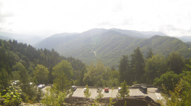 We do have some good news to share...after several weeks of very dry conditions (even severe drought and greater), West Tennessee has improved greatly. There is still some locations facing moderate to severe drought, but on a much more isolated scale than previous outlooks. Hopefully this trend continues and we see near normal conditions for the entirety of the state. 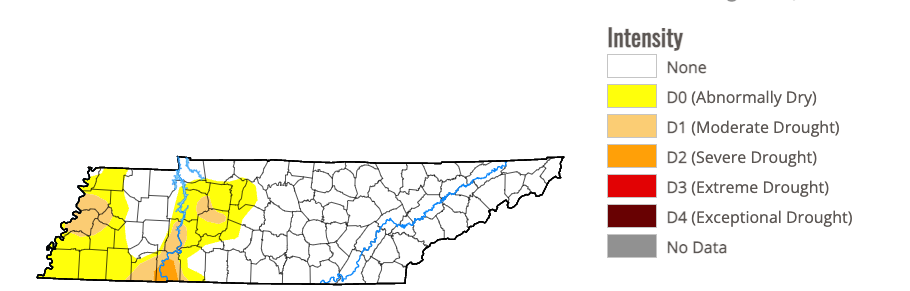 Overall, a boring summer-time pattern will find us through early next week. Afternoon pop up showers and storms will be possible each day, with afternoon highs in the upper 80s and low 90s each day. It will feel a bit warmer with the higher humidity, but nothing we haven't already seen so far this year. A cold front then approaches Tuesday, bringing better rain and storm chances to the area. Pre-recorded for 5pm weather broadcast
Beginning with a bit of a recap...Looking at July rainfall totals compared to monthly norms (below). If you recall from some of the earlier Tennessee drought maps, most of the state faced drought to some degree. By late July, a stalled boundary brought heavy rainfall to the area, especially across Eastern Kentucky. This largely helped the recovery of those dry spots, with some areas picking up well over 4" above monthly norms. However, looking west, who have continued to deal with dry conditions, less than normal rainfall amounts occurred. This has continued to aid in plaguing the area with moderate drought, though improvements have been seen through August so far. 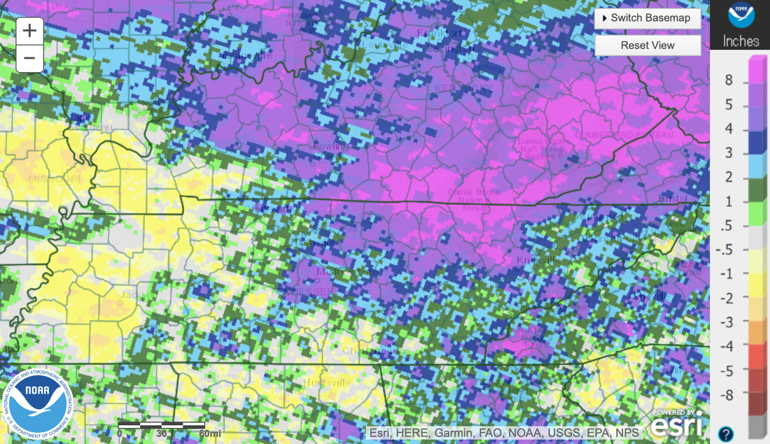 Inching a bit closer to the present, take a look at the last 7-day soil moisture amounts. On average, most areas have been near to slightly below (meaning loss of soil moisture). This is most evident across the Tennessee Valley and far northwest TN. Areas that saw pop up showers and storms, as well as repeated activity with the cold front, are doing better with increased soil moistures. Overall, the take away is that sunnier skies have led to a loss of soil moisture. This isn't a bad thing, we just can't continue this trend through the end of the month and into September if we want to stay out of any drought potential in the coming weeks. 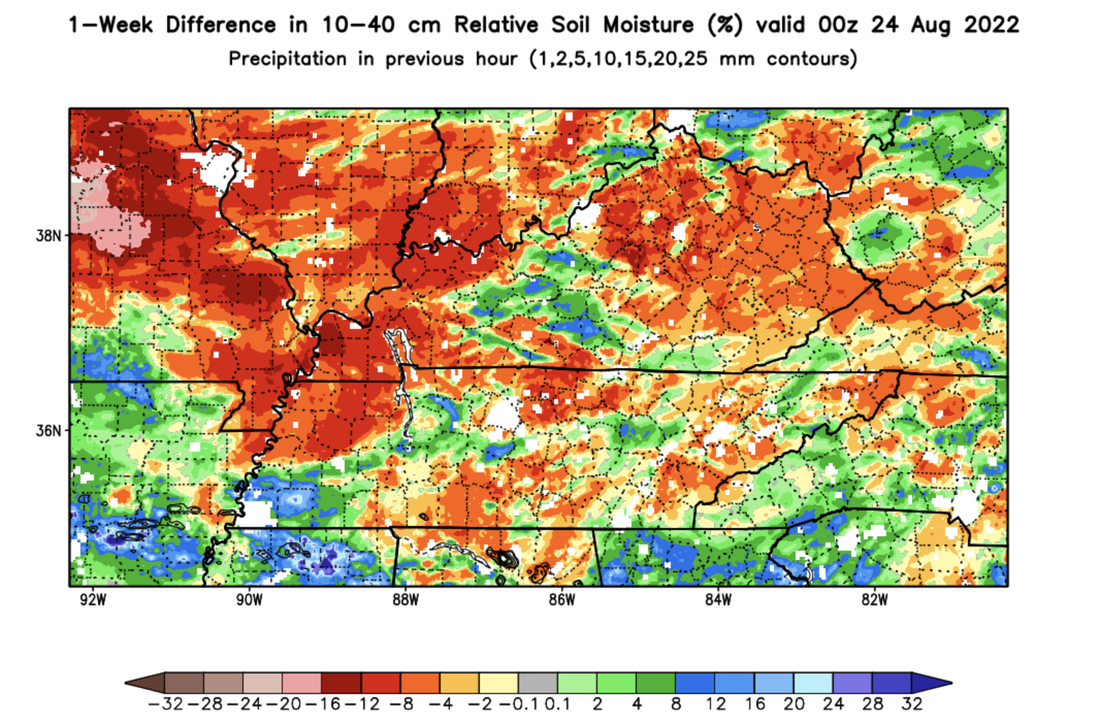 As far as the forecast up ahead, very summertime conditions can be expected. Highs will top out in the upper 80s today, with most staying partly cloudy. An isolated stray shower can't be ruled out along the TN/GA border and in the higher elevations, otherwise dry conditions prevail. With increasing moisture and temperatures tomorrow, pop up showers and storms will be possible in the afternoon, which will continue to be possible each day after (through at least the weekend). Highs will warm each day as well, finding the low 90s by Sunday.  Other than a few afternoon showers and storms each day, temperatures will be warming back up in the 90s. This is a change from the mid 80s we have been blessed with most of the month. Keep cool, stay hydrated, and have the sunscreen close by! Pre-recorded for 5pm weather broadcast
Sunshine should be out in full force today, allowing for UV indices to peak in the 8 to 9 range both today and tomorrow. This won't be as aggressive than a few months ago when ray angles were a bit better, but this is still high and sunscreen will still be needed! 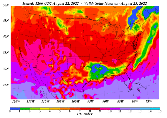 In terms of rainfall potential though, most veer dry today and tomorrow before shower chances return Thursday. Any development will be the usual summer time peak heating stuff, during the afternoon and early evening, before fizzling out overnight each day. Chances will generally be 30-40% Thursday and onward. Highs will warm up as well, returning to the upper 80s, and for a few, low 90s.  Looking longer term (early September), the Climate Prediction Center suggests near normal temperatures will stay in place. For us, that means mid to upper 80s, while precipitation is expected to be above average. Typically, September is one of our drier months, so we could see something similar to earlier this month and rounds of rainfall. For now, this is just an outlook of probabilities, with changes possible. 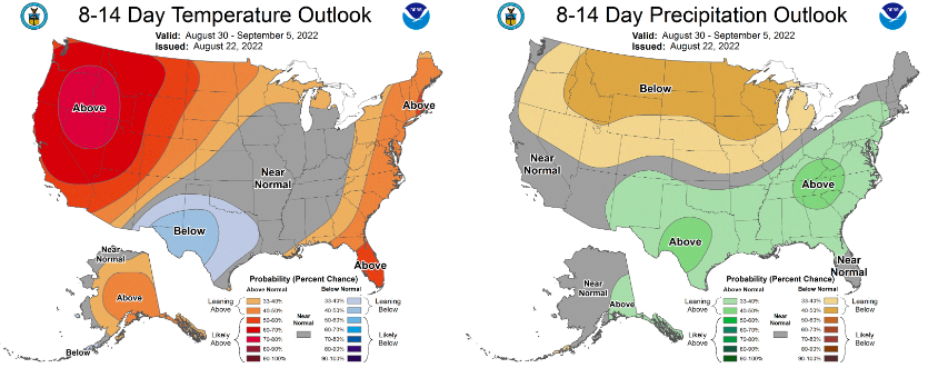 Highs will warm up in the days ahead, topping out in the upper 80s most days. It will feel a bit closer to real summer after low and mid 80s experienced for the past two or so weeks. Have a good one and don't forget to give us a follow on Twitter & Facebook @SecretCityWx Pre-recorded for 5pm weather broadcast
Hurricane season has been quit thus far, but should begin ramping up over the next few weeks and through the second half of the season. Looking at the current activity in the Tropics, a disturbance is just off the coast of Africa. Though chances for development over the next 2 days are low, it will be something to watch for. 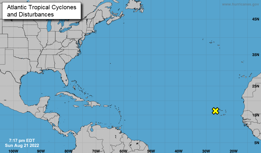 In terms of Tennessee, the last of a cold front is pushing through today. Other than a stray shower or two through early this afternoon, most will begin trying out today with sunshine in for Tuesday. Isolated to scattered shower and storm chances return Wednesday and through the remainder of the week, but this will be the typical summer-time afternoon pop up variety. Temperatures through the period will generally be near average (mid to upper 80s).  Over the next 7-days, heavy rainfall is expected just to our south. Looking at the WPC rainfall forecast, upwards of 5-7+ inches can be expected across Louisiana, Florida, and Mississippi. Flooding is likely in some spots, so let any family or friends in these areas know to take caution now! Across our neck of the woods, amounts upwards of half an inch will be possible through next Sunday. 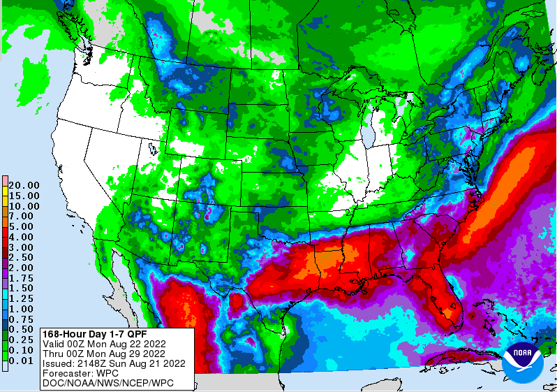 Overall, a pretty quiet week can be expected. Other than a few pop up showers and storms each afternoon, most veer dry with highs in the mid and upper 80s. Have a good one and don't forget to check out our video forecast below. Pre-recorded for 5pm weather broadcast
Shower and thunderstorm chances return tomorrow, as a frontal boundary pulls north. Scattered showers and storms will be possible through the weekend, with activity picking back up overnight Sunday and into Monday with a cold front. Activity will look to gradually diminish back off Tuesday and into mid week. Temperatures will remain below average each day through this period. |