|
Another pleasant day in the playbook today, with highs expected to top out in the upper 70s and low 80s. Most will veer dry, but an afternoon pop up shower or storm can't be entirely ruled out. Looking at the latest surface map, high pressure is passing through to our north. The frontal boundary that appeared to influence the area has shifted a bit further south, allowing us to stay mostly dry today and portions of tomorrow. By Friday, a passing upper level disturbance will bring the return for better showers and storms. 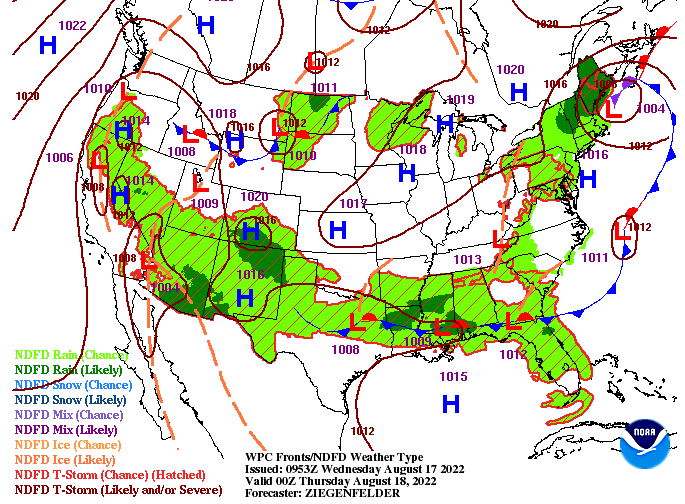 Looking into model guidance, things sit on track. Showers and storms will be best Friday and Friday evening, but a few isolated showers/storms will be possible this afternoon and again tomorrow. This weekend looks to quiet back down a touch with isolated to scattered showers/storms possible. An approaching cold front then brings increased activity Monday and towards mid week.  Overall, temperatures will remain below average for this time of the year. The trend looks to continue through much of the remainder of August as well, so fingers crossed this "early-fall like" feel continues. We all know Tennessee weather though, so take advantage of these conditions while we have them!
0 Comments
Fairly quiet conditions find us again today, with shower chances not arriving until tonight. Temperatures are a bit cooler starting out, with highs expected to warm into the low and mid 80s this afternoon. Compared to this time yesterday, we are beginning the day 2-5 degrees cooler, which will be reflected in afternoon peak temperatures as well. Overall, the upper level pattern will keep temps in check, with highs to be below average all week.  In addition to the cooler conditions, afternoon pop up showers and thunderstorms will be possible. Passing storm complexes could clip the area over the next couple of days, with a flash flooding threat in place tomorrow. Though the risk is low, it can't be ruled out. Stronger storms could produce heavy rainfall rates, which could result in localized flash flooding or higher running water bodies. Have a way to receive warnings if they were to be issued (though low chance). Showers and storms will be possible each day after today (at least through the weekend), mainly during the afternoon to early evening hours.  Other than the daily shower/storm threat, temperatures will be pleasant with a mixture of sunshine and cloud cover each day. Take advantage of the cooler stretch while it lasts! Pre-recorded for 5pm weather broadcast
Swinging back into the work week, highs will top out near to below average all week. Chances for showers and thunderstorms will be possible each day, with the quietest day coming tomorrow. A lower end flash flooding risk finds the area Wednesday. Check out more details by watching our video forecast below: Pre-recorded for 5pm weather broadcast
Pleasant weather conditions find us today and into the weekend! A few isolated afternoon showers and storms will arrive by Sunday, but with slightly better chances (20-30%) through the upcoming work week. Temperatures will stay at to below average through the period. Check out more below: A slow moving cold front will allow for the development of showers and thunderstorms again today. Fortunately, they won't be as widespread or as heavy. These will peter out overnight, setting up mostly sunny and cool temperatures Friday and through the weekend. Isolated to scattered afternoon showers/storms return Monday and through midweek. Pre-recorded for 5pm weather broadcast
A Slight risk of flash flooding is in place today. This means isolated to scattered instances of flash flooding is possible, particularly in slow moving thunderstorms and within areas that have already received heavy rains earlier this week. Use caution and have a way to receive warnings if issued. The slow moving boundary should shift southeast tomorrow, bringing drier and cooler conditions by late afternoon and through the weekend. More details on our video forecast below: Pre-recorded for 5pm weather broadcast
Showers to be scattered this afternoon, but those that do form will be slow moving and heavy rainfall makers. This will "prime" soil conditions for widespread activity on Wednesday. A flash flooding risk is in place as a result, so use caution and have a way to receive warnings if they were to be issued. Check out more details below: (Hint: Friday and this weekend look GREAT) Pre-recorded for 5pm weather broadcast
Good morning! Our continuous rounds of showers and storms find us once again today. The good news is activity is be fairly sparse, with only isolated chances (20-30%) this afternoon to early evening. The heavy hitters will arrive tomorrow and especially Wednesday. A slow moving cold front will crawl into the area, bringing between 1 and 3 inches (and locally more) the next few days. Looking at the Day 2 (Tuesday) flash flood potential, a Marginal to Slight risk is in place. A Slight risk entirely encompasses the area Wednesday, with isolated to scattered instances of flooding/flash flooding. 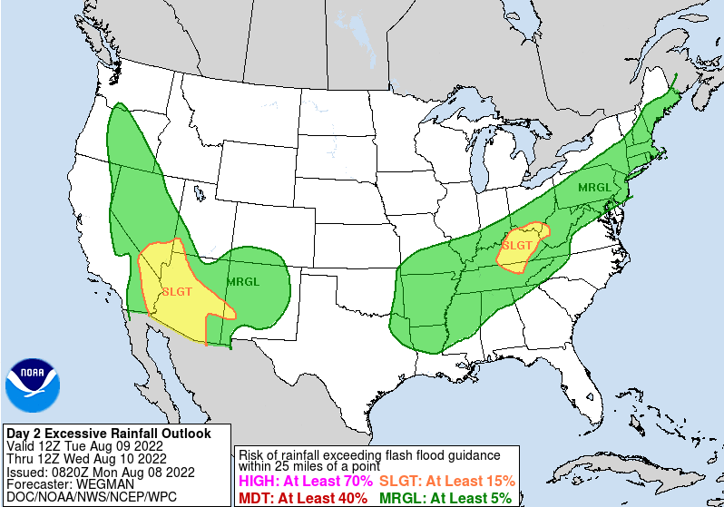 Breaking things down a little deeper, the approaching front will generate the development of storms tomorrow afternoon. These will continue, though fade is spread, overnight Tuesday. Activity will revamp Wednesday, bringing heavy rainfall rates and a few strong thunderstorms. As the boundary drifts south, lingering showers will be possible into Thursday, before much needed drier conditions prevail. We also find ourselves in a cool period, with highs Friday through the weekend BELOW average! Dew points will also be much lower, making things feel late Summer-ish.  Looking at the expected rainfall amounts on Wednesday, East Tennessee could see between 1 and 1.5". This is an average, with some locations likely topping 2" within stronger and persistent storms. Keep your safety in mind if in flood prone or low lying locations. Chances are a few of these locations will see higher running water tomorrow and Wednesday. 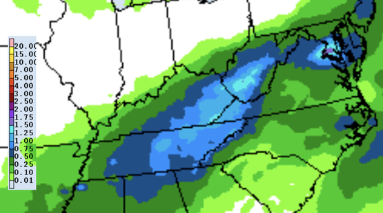 That will do it for today, our last wave of heavy rainfall and warm/muggy temps, before a welcomed pattern change late week. Highs Friday and the weekend will top out in the upper 70s to low 80s! Pre-recorded for 5pm weather broadcast
We will start off with positive news! In terms of the drought-front, we have improved this week. Not only has East Tennessee fully recovered, but West Tennessee has also shown signs of improvement. Check out the latest conditions (figure 1) compared to the prior week (figure 2) 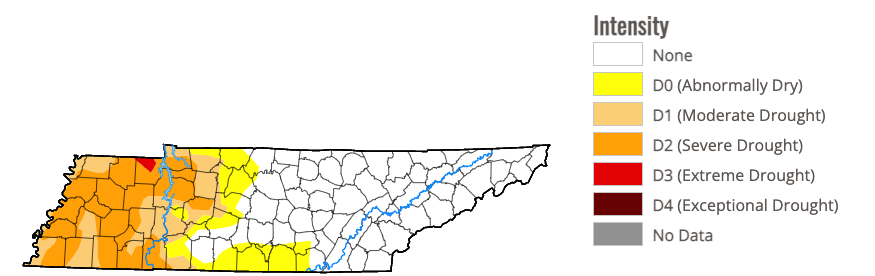 Figure 1 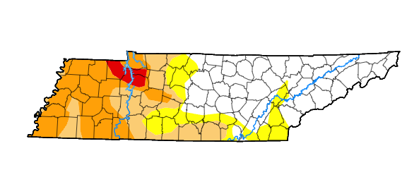 Figure 2 Back to the unfortunate reality ahead though, showers and storms look to ruin afternoon plans for at least the next 5-7 days. Given the warm and muggy airmass in place, as well as the current atmospheric pattern, daily showers and storms should be expected. With that said, there will be breaks with the most opportune time in the morning and at night. Showers and storms will be best during the afternoon and evening hours each day, with the better potential today and tomorrow, and then again next Tuesday and Wednesday. By late next week, high pressure looks to fill back in bringing some much needed drier conditions. Check out expected 7-day rainfall totals below. 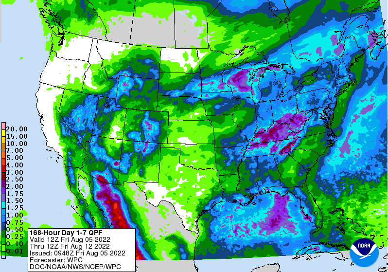 As mentioned, the best rainfall potential will fall later today and again tomorrow. The bulk looks to fall across Middle Tennessee and into Kentucky, but high-res guidance depicts activity picking up for us overnight tonight. This could pose some issues with flash flooding potential, as we are under a Marginal Risk today and tomorrow. Really any thunderstorm over the next week will have the potential to be strong and bring localized heavy downpours. Keep this in mind moving forward, with another good shot of rain Tuesday & Wednesday with the arrival of a cold front. Check out our graphical forecast under the "5-Day Forecast" tab at the top of the page for more information!  That will do it for today...another warm and muggy one is in store, with highs in the mid 80s to around 90 degrees. We gradually trend cooler moving forward, but rain chances continue. Have a great weekend, and don't forget to catch us on Twitter and Facebook for the latest updates (@SecretCityWx) Pre-recorded for 5pm weather broadcast
|