|
Check out the view over Oak Ridge this morning from the Stansfield's webcam! High clouds will continue to work through off and on today as our next system pushes in from the west. High's will be a bit warmer today's well in the mid 40's with 50's expected tomorrow.  Similar to our most recent system, a low will work just to our north keeping East Tennessee in the warm sector. Rain can be expected Saturday evening through Sunday morning with a few stray showers in the afternoon. As this low moves east, we could see some wrap-around moisture in the form of light snow showers and flurries. As of now, not expecting any accumulations in the higher elevations (with the exception for the highest elevations of the Smokies). We will cool back off early next week.  Tennessee as a state has had some improvement with abnormally dry conditions, but we will still have some work to do. I anticipate for this to continue improving as a weather maker moves through this weekend dumping between half an inch and an inch for much of the state. CPC patterns indicate above average precipitation now through February 10th, so state drought improvement looks likely.  Temperatures will continue to climb into Saturday with high's in the 50's and cloud cover on the increase too. Showers will dominate the second half of the weekend before much cooler air follows (30's) Monday and early next week. Check out more below: Pre-recorded for 5pm show
0 Comments
Good morning! Temperatures are hovering around the freezing mark right now with little room to increase by this afternoon. A cold front has passed through with our latest system, bringing much colder air (as seen below) across the eastern half of the US. High's today will top out in the upper 30's, near 40 with a gradual increase in temps through the weekend.  Along with increasing temperatures, a new system will build in for the middle of the weekend. Weather conditions stay dry tonight with sunshine returning Friday. By Saturday, cloud cover will be reintroduced and showers will arrive by the afternoon and through the overnight hours. Expectations for rain will be a nice soaking (0.5"-0.75" possible). Cooler air will again follow for early next week as clearing takes place as well. 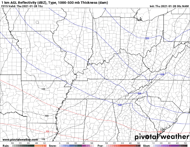 Long term, a deep trough will introduce well below average temperatures to the western half of the United States. Oppositely, the far eastern third will trend above average with much of Tennessee near average. This period has been ran from February 4th- the 10th by the Climate Prediction Center. 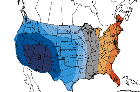 Temperatures won't fluctuate too much today but clearing will allow for low's tonight in the teens for most. Make sure to layer up tomorrow morning! High's will return to near average in the mid 40's before 50's find us back into the weekend. Pre-recorded for 5pm show
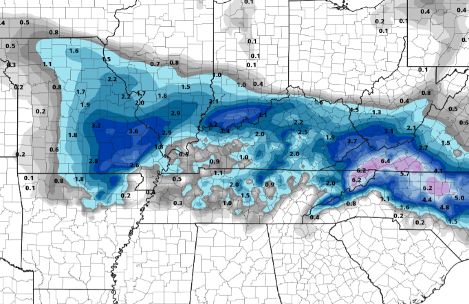
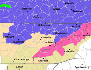
Good afternoon, I hope you are enjoying your Wednesday so far. Looking at radar, our next weather maker is producing rain showers to parts of West and Middle Tennessee. These will continue to work east this afternoon and evening bring a wide range of precipitation types. 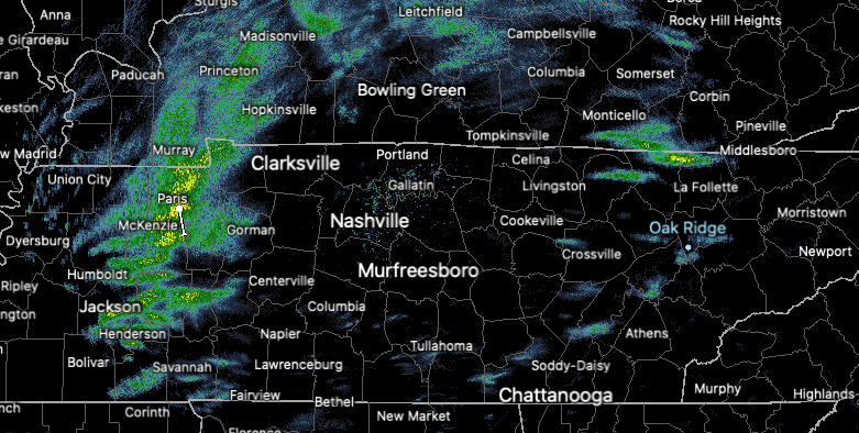 Getting a bit more in depth, we are on the warmer side of the system (not good for you snow lovers). Because of this orientation, precipitation will be in the form of rain (initially). As colder air on the back side of the system works in, a transition to frozen matter will take place. Because of the vast elevation difference across East Tennessee, this will first come for the Plateau and Smoky Mountains. A change over late in the night is possible across the Valley locations, but no snow related impacts are expected (dusting on grassy surfaces possible). However, patchy black ice will be a concern as overnight low's dip into the upper 20's. Use caution as slick spots are possible for the roadways in the morning Thursday.  Getting into snow totals, things will vary. If you are living in the Plateau and counties bordering Kentucky, you have the best opportunity for accumulating snow. We are anticipating upwards of 1" possible for these locations but locally higher amounts are possible. It is also important to highlight the Plateau and northern counties are under a Winter Weather Advisory tonight. Working east, as mentioned, Valley locations should see most precipitation in the form of rain with a brief transition possible early Thursday morning. Getting to the Smokies, it is a different story. The high elevations will likely see upwards of half a foot +. These areas are under a Winter Storm Warning (highlighted pink).
We will continue to monitor this system as it works east this afternoon and for any changes that could occur. For now, expect minimal impacts across most valley locations with slick spots (from black ice) the exception into Thursday morning. You may also send us reports via Twitter/Facebook/Email and we will pass those along to the NWS and other viewers. Stay warm and safe as we work overnight and into Thursday. Are you enjoying your Tuesday? Take a step outside if you get the chance as conditions are gorgeous for this time of the year. Temperatures right now are in the low to mid 60's across the Valley with sunny skies overhead. We are 20+ degrees above average for this time of the year with a big flip in store ahead. 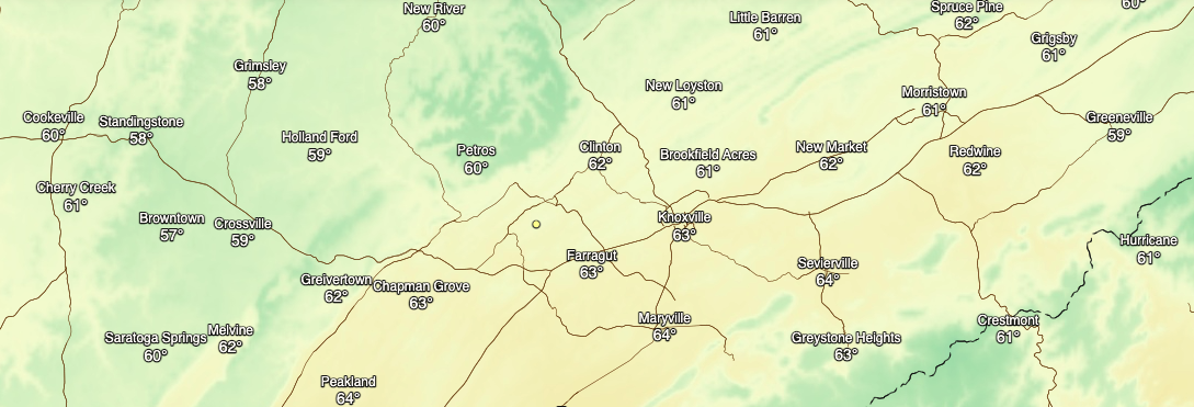 Based on the current surface map, an area of low pressure is working through the Central Plains dumping lots of snow as it works east. With the arrival of this system tomorrow afternoon, we'll see cloud cover on the increase tonight through Wednesday. With it will come a mixed bag of precipitation. First, we will start in the form of rain before a transition to mix and snow is likely overnight as temperatures drop. Looking at this model in particular (below), a more realistic play-by-play is pictured. Oppositely, other trends show a faster transition with more snow in the forecast. Given our climatology, the latest trends with similar systems in the past, and the overall agreeance in ensemble data, I am incline to agree with lesser amounts (more details below). Once this system works through, you can anticipate cooler temperatures Thursday before trending back upward as another system arrives for the weekend.  Continuing on, model data is still rather uncertain. Some data suggests better totals while others suggest little to none. Given the dynamics of this system, snow ratios will be much lower than 10:1 (meaning 1 inch of rain = 10" of snow and visa versa). I would put ratios in the 8:1 ballpark as overnight temperatures are expected to be right around the freezing mark. Given this, amounts in the left graphic (below) will be much less. Moving to the right graphic, a more realistic outcome is presented. With the Plateau several thousand feet higher than the valley locations (likewise for the Smokies), snow is more likely in these areas. As of now, my snow forecast is as follows: Valley: trace to a dusting (mainly idle cars, trees, and elevated surfaces Plateau: up to half an inch with locally higher amounts possible Smokies: up to half an inch for the foothills with 4+ inches likely as you head up in elevation Keep in mind there is still a lot of uncertainty within the data so changes are likely. Be sure to check in for more details as we work into Wednesday, but for now, I don't anticipate too much excitement for those in Valley locations (good news for travelers).
Be sure to enjoy the sunshine and unseasonably warm temperatures across East Tennessee today. Changes are in the forecast ahead with rain, mix, and snow all likely. Check out more details below! Pre-recorded for 5pm show
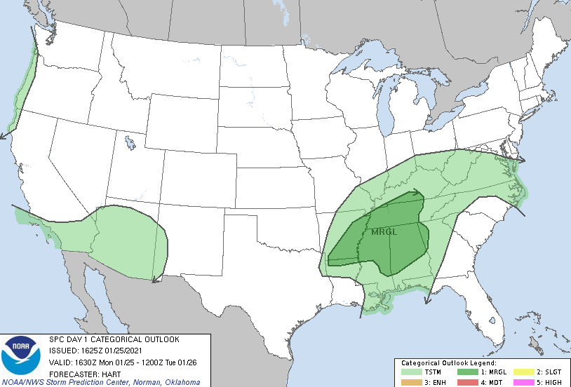
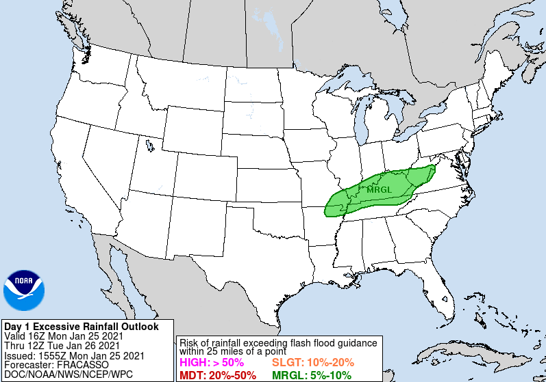
Good afternoon and I hope you are staying dry today. The current radar (as of 12:55 pm) show's a swath of moderate to heavy rain working through Knoxville and in a northeast direction. We will continue to see these waves of showers/storms work through this afternoon and evening.  Touching on our forecast late last week, we warned heavy rains could bring flash flooding potential to parts of the northern plateau and counties bordering Kentucky. As you can see below (right) a Marginal excessive rainfall outlook has been issued for all of Kentucky and the northern quadrant of Eastern Tennessee. Be mindful of low lying and flood prone areas. Please send reports to us via email & social media as we'll pass those along to the NWS. In addition to limited flooding potential, the SPC has issued a marginal risk for severe storms across Western and Middle Tennessee. This does include the Plateau. Some instability this afternoon could fire off some heavier showers/storms which could create lightning, gusty winds, and localized flooding. Again be weary, take your time if on the roads, and pass along any reports you may have.
Looking to what's next, this is one of two systems that will impact us this week. The next one arrives later Wednesday bringing much cooler air and the chance for a few snow flakes. A quick moving low, now developing across NE Texas, will work eastward bringing cloud cover back across the area Wednesday. Showers will begin the show with a transition to mix and snow late in the night and early into Thursday morning. Light accumulations are possible across the higher elevations while little to no impacts are expected across the valley locations as of now. Patchy black ice is something we'll monitor for as we get closer to time.  Warm temperatures will be around tomorrow with some locations seeing near 70 degrees (yes I promise it's still winter). Our second system later in the week will knock temperatures back down to average, and slightly below, bringing another round of rain, mix, and snow. Stay safe this afternoon, send us reports if you can, and check in for the latest on our Twitter and Facebook. Pre-recorded for 5pm show
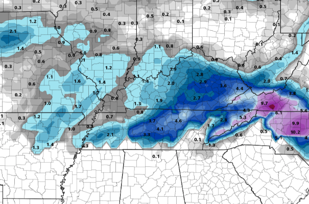
Cloud cover is thinning across East Tennessee this afternoon with temperatures warming up into the mid 40's (high's in the low 50's). A recap of the states' current drought shows an ever expanding abnormal dry line. This now encompasses nearly 3/4 of the state as of yesterday. The good news is this weekend could help these conditions significantly improve. 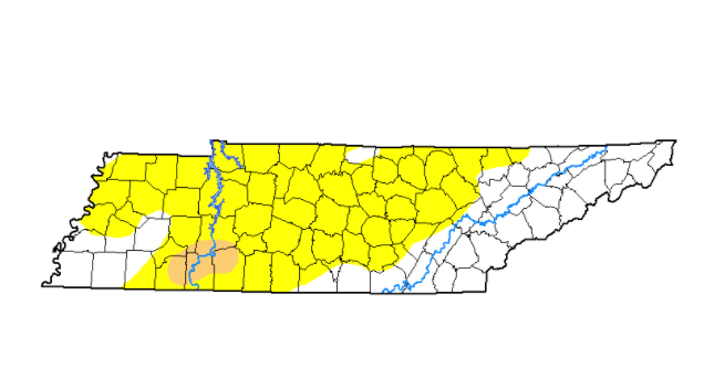 As for today, sunshine will work back in and continue for most of the weekend. Saturday will be a bit cooler (in the mid 40's) but sunny skies should make it feel comfortable. By the end of the weekend, cloud cover increases across the region as our next system builds in. Showers will arrive towards the evening and overnight hours and throughout much of Monday. Earlier data suggested the bulk of rainfall across central and eastern TN but this now has shifted further north.  Looking at the expected rainfall Sunday night through Tuesday morning, the heaviest swath of rain is across central Kentucky. This doesn't mean we are out of the woods. Localized flash flooding will be possible along the Plateau and specially, the northern Plateau and counties bordering Kentucky. East Tennessee as a whole can anticipate upwards of 1-2 inches (decreasing as you move west to east). 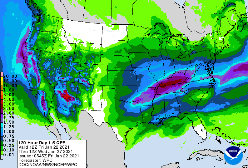 Data continues to narrow in on rain to the north but we'll continue to monitor for changes. As of now, the biggest threat for any flash flooding will be the Plateau and northwestern counties bordering Kentucky. Have a great weekend and don't forget to check out our video forecast below. Conditions this afternoon are somewhat gloomy with cloudy conditions and mild temperatures. This shot comes from I-40W in Knoxville. A few showers still hang out in the Smokies, otherwise we are dry across East Tennessee. Temperatures are currently in the lower 40's with high's likely topping out in the upper 40's.  A few isolated showers could be possible for the deep southern counties of Tennessee, otherwise we stay dry this evening and overnight. Working ahead, high pressure builds in for Friday clearing things out but keeping things near the norm (mid 40's). Overall, conditions continue to improve the next couple of days. Sunny skies stick around for Saturday before our next weather maker inches in late Sunday. Heavy showers are likely early next week giving way to flash flooding potential across the state.  Looking a little more in detail, temperatures are expected to be above the average early next week (indicated by the red). Along with abnormally warm temperatures, we will see abnormally high rainfall as well. We touch on this a bit more in the video forecast below, but guidance & ensemble data is suggestive of 2"+ of rainfall Sunday night through Tuesday. Some areas could see as high as 4 inches over this period so we are keeping a close eye on magnitude, duration, and location. 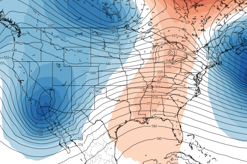 The next few days should be pleasant before heavy rain chances arrive late weekend and early next week. Changes are likely but flash flooding potential is on our radar. More details below. Good afternoon! Sunny skies are out with temperatures currently in the low to mid 40's. Satellite shows the cloud cover associated with our next system just to our south and west. Increasing cloud cover will be seen late this afternoon and overnight. 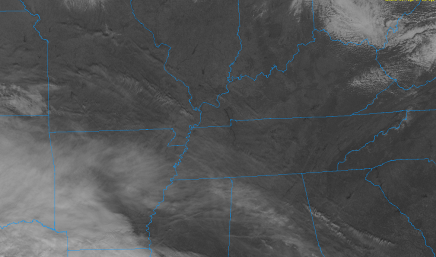 As mentioned above, a low to the south will bring rainfall to the area late tonight and early into Thursday. Guidance suggests a nice bed of showers through the first half of the day before cloudy skies take over the later half. By Friday, clearing will begin to take place for the afternoon with sunshine returning Saturday. High's will also sit at to slightly above average, so things should be pleasant Friday afternoon and into the weekend.  With showers likely in the morning hours Thursday, use caution on your way to work and school. Most areas across East Tennessee should see upwards of a few tenths of an inch with enhanced rainfall, up to half an inch, for the windward side of the Plateau. Drier air will work in by the evening hours tomorrow as high pressure begins settling in Friday. 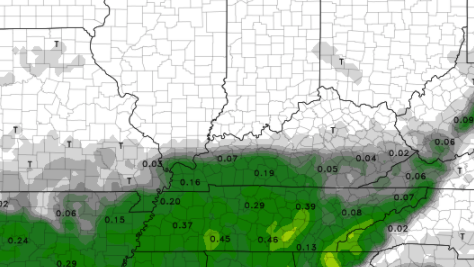 Enjoy the conditions today before a bit of rain and messy conditions arrive for the AM commute Thursday. Those with weekend plans should enjoy Saturday and much of Sunday before rain chances return Sunday night and Monday. Pre-recorded for 5pm show
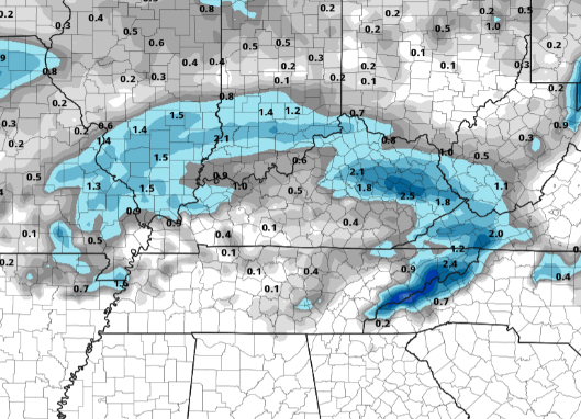
A weak front will progress eastward through the day today bringing some light and isolated showers through the early afternoon timeframe. Cloud cover will continue through this time period as well before gradually clearing out this evening and overnight. High pressure will be in place for Wednesday with cooler temperatures (mid 40's). 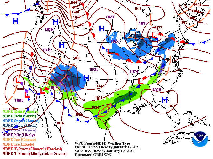 Better rain chances arrive later in the work week as a system is expected to arrive from the south. As you can see below, much of the southern half of the state will see rainfall into Thursday and early Friday. Uncertainty still lies in how much rainfall the area will see so for now, we are in the 50-60% ballpark. Changes are likely in the days ahead. For Saturday, things clear back out with high's near average.  Early indications suggested a cold flip toward the end of this month but current data keeps the brunt of cold air west and to our north. With that said, we will see some cooler pass through toward the end of January and into early February. The balance between above average temperatures (a few days this week and ahead) and below average temperatures (also mixed in this week and ahead) keep temperatures (overall) average now through mid-February (according to the CPC). We continue to keep a close eye on the patterns going on worldwide and for any changes we could see across the southeast. 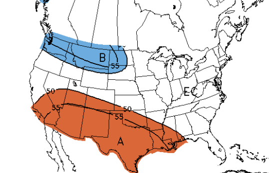 Satellite shows some breaks of sunshine and clearing for parts of Middle Tennessee. We'll likely see some better shots of sunshine toward the mid-afternoon hours, so take advantage if you can. We'll cool down a few degrees tomorrow but stay on track with norms this time of year. Happy Friday to everyone! We are seeing showers work through mainly east of Knoxville with some clearing in from the west. This is all apart of a low currently located to our north near the Great Lakes region. With the cold front moving just behind the leading rain shield, temperatures will stay in the 30's for much of the day. Some clearing should also set in allowing for a bit of sunshine this afternoon. 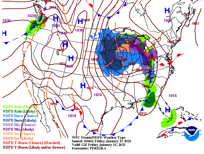 As we work ahead, some changes are in store. Previous data and forecast's suggested the low to track a bit further north than it is now. With the change comes some slightly hightened snowfall chances. Wrap around moisture from the low should bring isolated to scattered snow showers through Saturday. High's will settle in the mid 30's for most Valley locations so most precipitation should be in the form of frozen matter. By Sunday, a few flurries to light showers will be possible before clearing begins overnight and into Martin Luther King Jr. Day. We look to warm back up and clear out by early next week.  The big question I'm sure many are asking is: How much snow can we expect? Well, not much. With enough moisture for a few snow showers we could see an event similar to early this week with a light dusting on grassy surfaces, trees, and sitting vehicles. I don't anticipate a huge disruption to the roadways and transportation but slick spots will be likely in the morning and late evening hours Saturday/Sunday. Other areas across East Tennessee (Plateau and Foothills) can anticipate 1-3" at best Saturday into Sunday with locally higher amounts possible. 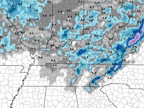 If snow is in the forecast you can be sure to expect cold temperatures to accompany. A look at the NWS forecast for East Tennessee tomorrow shows high's struggling to find the upper 30's with cloud cover and wintry precipitation likely at times. 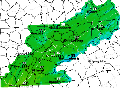 Be sure to stay warm and stay safe tonight and through the weekend. If higher moisture can manage to stick around into tomorrow, we could see more impressive totals. For now, the consensus across the data doesn't suggests this solution. We'll have updates as always through the day and into the weekend! Pre-recorded for 5pm show
|