|
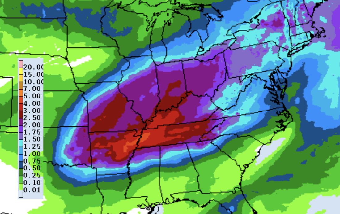
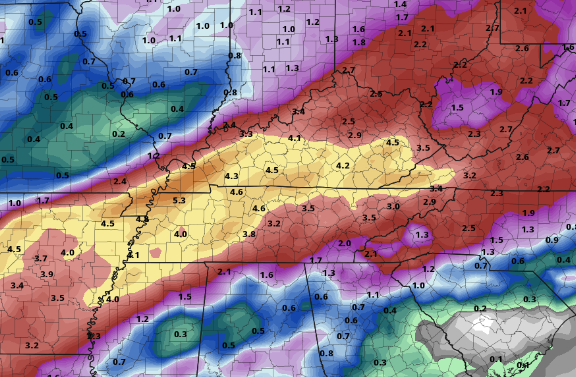
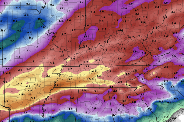
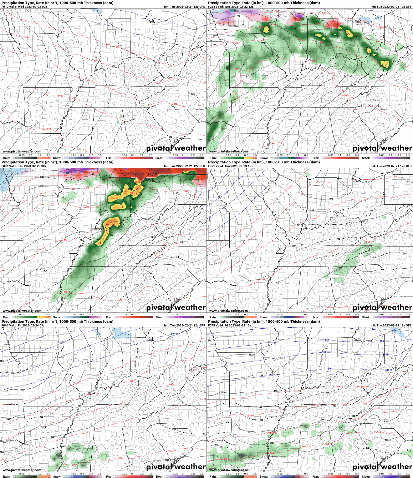
A beautiful morning across the Volunteer State as we start most sunny and generally stay that way through the day. Other than a few high clouds it should be a pleasant one with highs warming into the upper 60s and low 70s. Take advantage of the sunshine today into tomorrow, as it'll be the last we see of it until the weekend. Looking at model guidance, there still remains quite a bit of uncertainty regarding our next couple systems. Up first is the one arriving late tomorrow (really tomorrow evening and overnight), followed by a second one Thursday into Friday. System number 1: A cold front will pull east tonight into tomorrow, where cloud cover will increase throughout Wednesday. This will eventually lead to showers as a warm front builds north Wednesday night. Some activity Wednesday night into Thursday could be strong to severe, with gusty to damaging winds and heavy rain the main threats. Several inches of rainfall will pose both a flash flooding risk as well as a river flooding risk between Wednesday night through Friday night -- have a way to receive watches and/or warnings if they were to be issued. System number 2: With heavy rain in the realm of possibilities Wednesday night into Thursday, this second system could add to the fire. This will be particularly so if we see thunderstorms develop (which is likely). The good news is better agreement on a low track well north and west of the area favors lesser rainfall locally. There will be a brief break sometime midday Thursday (at least lesser shower chances) before activity picks back up Thursday afternoon and evening. Heavy showers and a few storms will be best Thursday night into Friday. We will continue to monitor trends moving forward and provide the latest here and on Twitter/Facebook. Looking at the rainfall amounts from the Weather Prediction Center, we are talking ranges of 2-4". These will be highest the further west you go, but still a soaker no matter where you are. Again flash flooding and river flooding will be a concern, particularly for locations that have passing thunderstorms and repeated activity. Enjoy the last of the sunshine and dry conditions, as showers and storms return Wednesday night through Friday. By the weekend, a post cold front airmass will allow for drier and much cooler conditions. Highs will be near average Saturday, moderating Sunday and into early next week. Check out more details below: Pre-recorded for weather broadcast
0 Comments
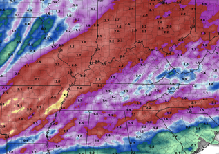
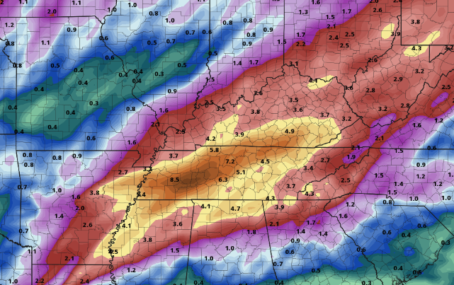
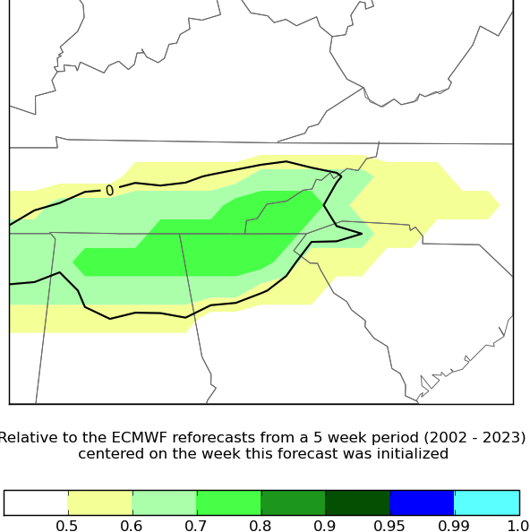
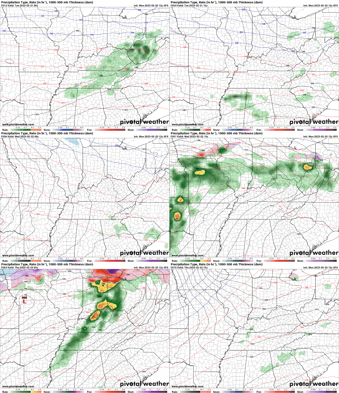
Good morning! Quiet so far but that'll change into this afternoon. A cold front is building across West Tennessee, where showers and possibly a storm will fill in just after lunch today. These will be widespread in nature, but diminishing by late evening. Additionally, it's going to be a breezy one. Winds out of the southwest will blow between 10 and 20 mph with gusts of 30 to 40+ possible in the valley. Even higher readings are expected for the elevated terrain. Following the front tonight, high pressure will bring dry conditions Tuesday. Highs will maintain their above average state, topping out Tuesday in the upper 60s and low 70s under partly cloudy to sunny skies. This will be short lived unfortunately, as a very unsettled pattern presents itself Wednesday through late Friday. Several passing low pressure systems will bring rounds of showers and some storms (some of which could be strong to severe) during this timeframe. Showers will generally start Wednesday night ad continue on and off with each passing system through Friday night. Breaking this down further, how much rain are we actually talking? Well...thats still largely up for answering. What can be said is rain is certain at times Wednesday through Friday. Guidance shows the large contrasts between various models, ranging from 1-2" all the way up to 3-5". Probabilistic data further highlights these differences, making it challenging to pinpoint exact totals at this time. With all of that said, flooding (of rivers) will be something on our radar. Flash flooding will also be a concern, particularly Thursday night into Friday. Adding more fuel to the flame, some strong to severe storms will be possible with strong wind gusts (outside of storms) again likely Friday. Continue to check back in with us for the latest forecast. SOME range of possibilities (take with a grain of salt)So in total, what does this all mean and what the heck is this graphic below? Well there's quite a bit of uncertainty. Piecing everything together though and analyzing the EFI, heavy and unusually high rains look increasingly likely. This graphic below assesses what ensemble members suggest versus whats common for late February. Values of 0.7 and higher suggest an extreme or likely case for high rainfall. Though this is just one piece of evidence among many, this is just another nudge toward lots of rain being possible. As far as what we are thinking total wise Wednesday night through Friday night, we are in line with 1.5-3" with locally higher amounts exceeding 4 to 5 inches not out of the realm of possibilities. Obviously we hope for a more southern track with system number one (Wednesday night into Thursday), while a more northern track with system number 2 (Thursday evening through Friday), but time will tell. For now, understand there's large uncertainty in guidance varying from low track, strength, speeds, and more so tune back in for further updates. We will have a better idea moving forward and guidance will narrow in on better agreement. Pre-recorded for 5pm weather broadcast
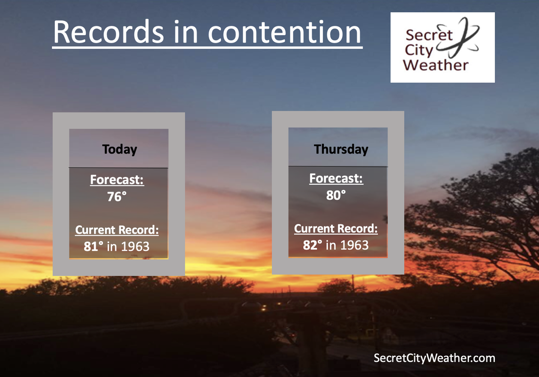
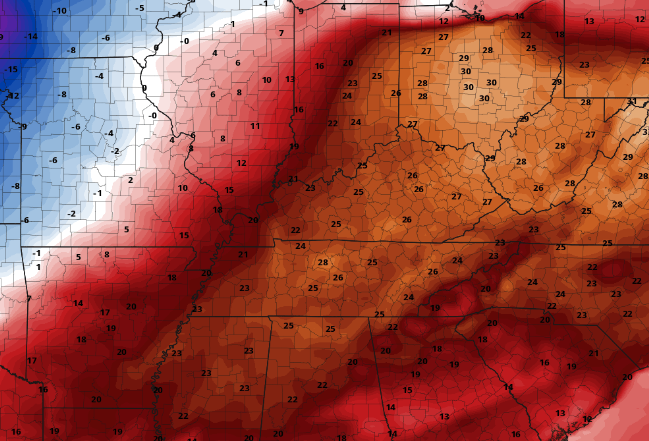
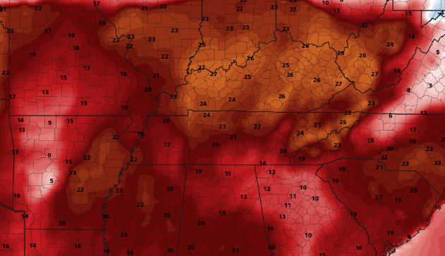
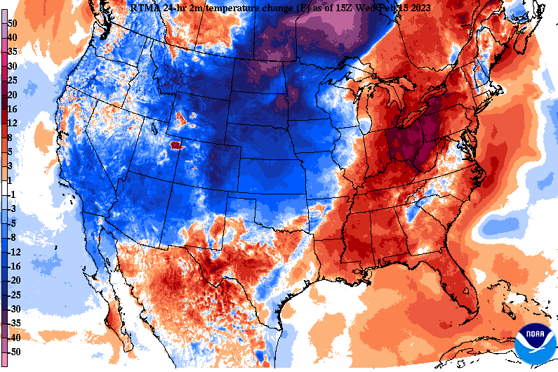
Early morning forecast for my East Tennesseans! Showers will continue to pour in the next couple of hours, with the best chances into Kentucky. Fortunately, clouds begin clearing out mid morning to the early afternoon, allowing for sunshine the remainder of the day. Highs will again be very warm, even near records, before a cold front slides through overnight and cooler air settles in Friday. More unsettled weather finds us ahead...check to our video forecast below for more details. Good afternoon! Are you enjoying the now sunshine and warm air? If so, more is on the way tomorrow. Cloud cover has been slow to retreat this morning/early afternoon, but most are now seeing sunshine across East Tennessee. Looking at the records we have, we could be close to breaking a couple. Below are the current high temperature records for today and Thursday. If it was not obvious enough we are well above average by throwing in near record temperatures, take a look at the graphic below. This image is the difference between our average highs and those of which we are expected to see tomorrow. We are talking temperatures 20-30 degrees above the norm! After our warm stretch, cooler temperatures do find us into Friday as a cold front passes through Thursday night. Until then, a frontal boundary will approach tonight bringing showers and maybe even a storm. We will begin to clear back out tomorrow, before isolated shower chances with the cold front find us Thursday night into Friday. Though Friday will generally stay on the drier side, cloud cover will remain in place. The next disturbance will then arrive Friday night and Saturday, bringing the best shower chances over the next 5 days. Lingering activity will remain through Sunday before yet another system into early next week. Temperatures will remain above average through at least early next week, but be the warmest today and tomorrow. Mid 50s should be expected Friday and Saturday, before warming back towards the 60s and even 70 Sunday and Monday.
Good afternoon! Cloud cover slowly cleared last night and that has lead to mainly high clouds this afternoon. This will be short lived though as a warm front is set to build north tonight bringing isolated rain chances and mainly increased cloud cover. If you haven't been outside yet, open that door. Temperatures currently range in the 60s, with highs to warm into the upper 60s and low 70s before days end. With the warm front en route tonight and tomorrow, temperatures will soar even warmer, with near record highs forecast. As of now, the record high in Knoxville for Wednesday is 81 (set in 1963) while Thursday is 83 (also set in 1963). Though we may struggle to achieve record breaking temperatures tomorrow, Thursday we definitely stand a close chance. It will come down to how much sunshine we see through the day and if winds are too gusty to maintain warmer surface temperatures. Either way, it's going to be very warm for this time of the year today through Thursday. As far as rainfall is concerned, a dynamic and unsettled pattern will remain in place. The warm front will allow for increased clouds tonight along with isolated shower chances. Activity will generally hold off through the day tomorrow, before activity returns best Wednesday night into Thursday ahead of a cold front. Once this passes through later Thursday, cooler air (back in the 50s) returns on Friday. Another system then brings shower and possibly storm chances back in Friday night and into the weekend. As of now, flash flooding with this later series of disturbances is low, but something we can't rule out. That will wrap it up for today. If you haven't already, be sure to head outside and enjoy the warm air and sunshine. The Spring-like warmth will stick around through Thursday, before more reasonable (but still warm) highs return Friday and Saturday. Pre-recorded for 5pm weather broadcast
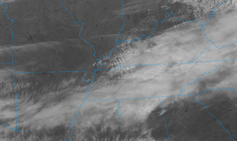
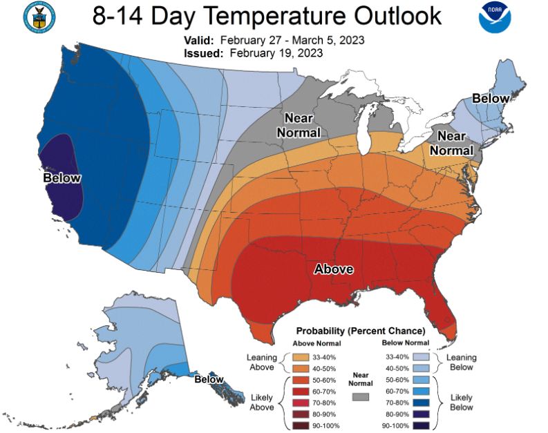
I hope you are enjoying George Washington's Birthday! Though it's been rather cloudy/foggy, at least the temperatures aren't too bad. We will continue warming this week, to even near record highs, before cooling into Friday. As far as the planner for the remainder of the day today, cloudy skies will persist with isolated to scattered rain possible. The best chances will arrive this evening and into the overnight. Looking ahead, a frontal boundary will stall out across the area, allow for the focus of moisture to be nearby. As such, repeated light shower activity will be possible each day. More or less, showers will be on and off but remain generally light in nature. Towards Wednesday night into Thursday, a last push of the boundary will allow for cooler conditions to fall into place by Friday but another disturbance enters our doorstep bringing continued rain chances again into the weekend. Further out in time, the CPC predicts our very mild winter to continue. This look comes late February into the first week of March, where above average temperatures are expected to continue. Paring this with the rainfall outlook, near normal to slightly above normal is forecast. Overall, the pattern is an unsettled one. There will be numerous shots for rain this week, fortunately activity will be light and scattered in total. This means flooding/flash flooding potential is very low. That said, if a few thunderstorms do develop Wednesday, we could see locally heavy rainfall within them. Thursday will be our best shot to see some sunshine along with the most limited rain potential. Pre-recorded for 5pm weather broadcast
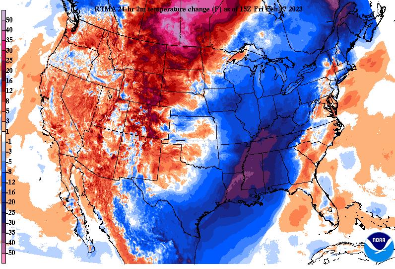
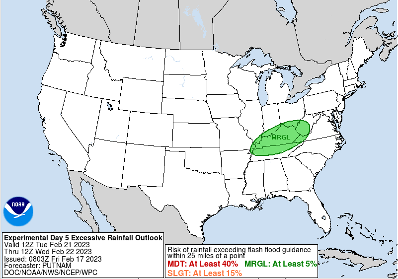
Good afternoon! It is certainly much cooler outside than yesterday and that is reflected on the graphic below. A swing of 25+ degrees is being felt, where most temperatures won't top 40 degrees through the afternoon hours. Fortunately, we do have a big warm up on tap, with highs warming to the 70s by mid next week. Looking below, the Weather Prediction Center has highlighted a rare day 5 marginal risk of flash flooding. There is still a lot of uncertainty in amounts, timing, and strength, but it is something on our radar that we will be watching closely. A frontal boundary will sag south providing rainfall chances into early next week, followed by a developing and passing low and cold front. With the boundary laying nearby, repeated showers could induce flash flooding by mid week as the low draws closer. Take this all with a grain of salt now and tune back in for updates early next week. Sunshine will be slow to return today, but western and the central valley counties will likely see it first. Into the weekend, most stay sunny with temperatures warming into the mid 50s and beyond by Sunday. Cloud cover and shower chances then return for the upcoming work week. Have a great weekend! Pre-recorded for 5pm weather broadcast
Generally cloudy as of noon, but activity is to quickly return later this afternoon and into the overnight. Some storms could be strong to severe with the main threat damaging wind gusts. Additionally, and likely more concerning, is the flash flood risk. A slight chance is in place today, so some locations could see isolated issues. Have a way to receive warnings through early tonight and know what to do if one were to be issued. Pre-recorded for 5pm weather broadcast
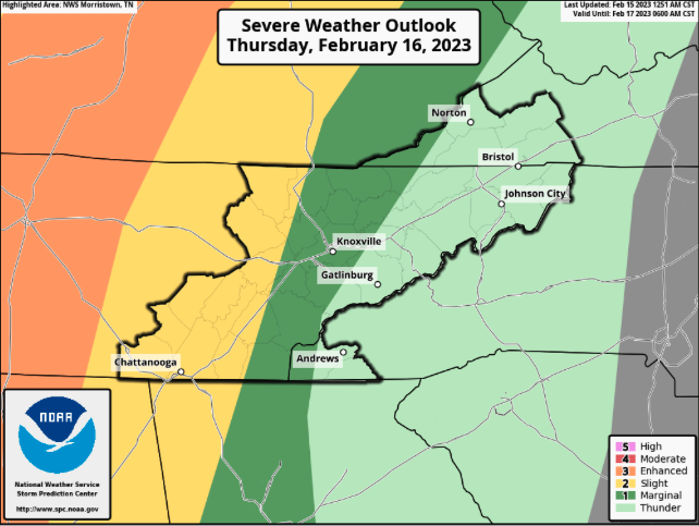
A warm one here on this Wednesday and it will remain that way again tomorrow. A warm front is expected to meander north overnight, keeping overnight lows well above average for this time of the year. This will also allow for our first batch of showers/storms to overspread the area. As far as through the afternoon today, generally cloudy and warm. A few isolated to scattered showers will be possible towards the evening, with better potential overnight. With the low and associated cold front drawing closer late tomorrow, the risk for strong and severe storms will be possible. There is still some timing concerns, which will play a role in the outcome, so stay close for updates. As it sits now, the bulk of strong to severe storms will stay contained to Middle Tennessee, but a few longer lasting cells could bring damaging winds to the Plateau and into the Central Valley late tomorrow afternoon and evening. If this line ends up moving a bit quicker, a higher risk of storms will be possible versus a slower progression and lesser chance. Either way, the primary risk will be damaging wind gusts. Looking at the progression of all this, our first round pushes northward overnight and into Thursday morning, before a brief pause in activity finds us into the middle of the day. As the trailing cold front then shifts east, a line of strong to severe storms takes shape west. This line will glide east weakening as it does so. Again timing will play a role, as a quicker progression could allow for stronger storms while a slower one would lessen those odds. Stay weather aware tomorrow as both strong to severe storms and flash flooding will be possible. Once the cold front slides through late tomorrow, much colder air filters in Friday. Highs will only top out in the upper 30s to low 40s, before a gradual warm up through the weekend. Plenty of sunshine finds the area Saturday and Sunday. Pre-recorded for 5pm weather broadcast
|
Your trusted source for everything weather in East Tennessee.
Social Media
|

