|
Pre-recorded for 5pm weather broadcast
0 Comments
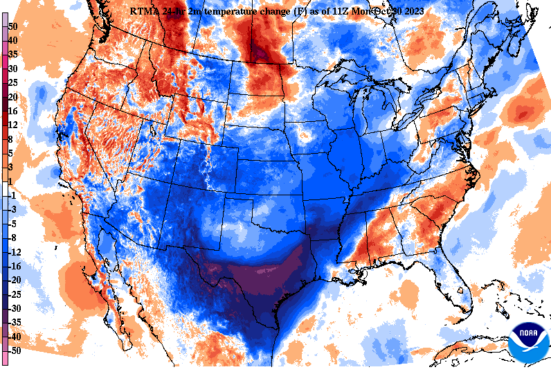
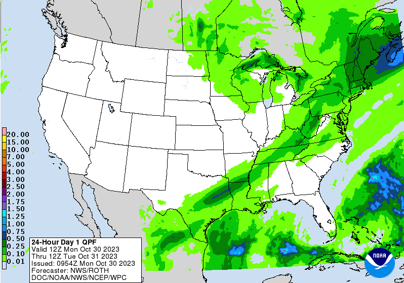
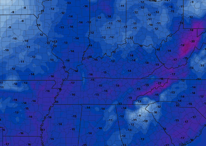
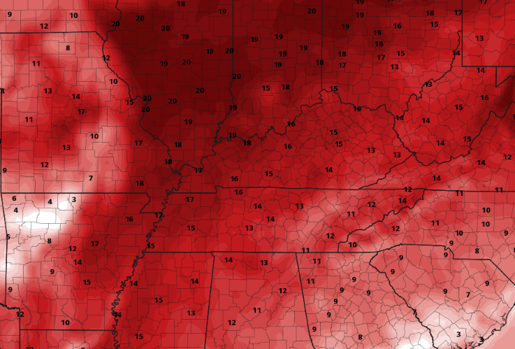
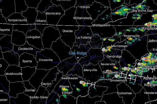
Good morning! If you haven't heard, a taste of early Winter is on the way. Looking at the latest 24-hour temperature change map below, MUCH cooler air is seen just upstream from the Rockies to the Tennessee Valley. This will spill into East Tennessee this afternoon and through midweek, leading to chilly temperatures. As far as the expectations for today, a cold front is sliding through now. This will allow for showers to fill in late morning into the afternoon, eventually exiting the area tonight. Rainfall amount with this system will be minimal, generally a tenth of an inch or so, but something is better than nothing. That is especially so with the drought we have across the state. Much cooler air finds us tonight through Wednesday night, with near record values possible for some locations. This model is depicting average temperatures to those of which will be possible Wednesday afternoon. As you can see, we will be 10 to 20 degrees below our usual late October to early November average, so bundle up accordingly! The good news is this will be temporary, as average to even above average temperatures return late work week and into the weekend. Until that point, brace for cold highs and even colder overnight lows. Temperatures will drop from this point through the end of the day, with highs Tuesday in the low to mid 50s and highs Wednesday in the 40s to around 50 degrees. Like highs, lows will drop into the upper 30s to near 40 tonight, upper 20s to near 30 degrees Tuesday night, and mid 20s Wednesday night. This should end/kill what is left of the "growing season," which is why the National Weather Service has a Freeze Watch in effect for Tuesday night into Wednesday morning. A quick moving disturbance to our north will bring some increased clouds late Tuesday, where a few sprinkles to even flurries (yes, you just read that) could fall. The best chances will be for those furthest north and in the higher terrain, but a few could fall in the northern valley too. High pressure then allows for plenty of sunshine Wednesday through the start of the weekend. Have a good one and stay warm the next few days! Pre-recorded for 5pm weather broadcast
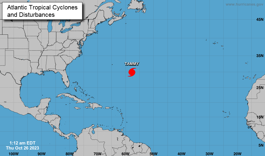
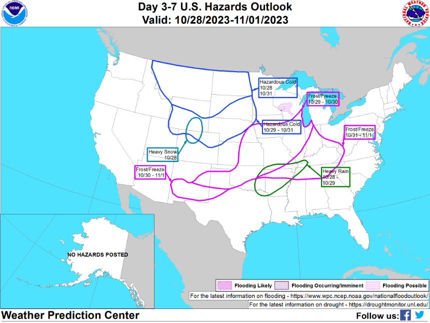
I hope your Thursday is off to a good start! We are looking at a beautiful day ahead, with warm temperatures and sunny to partly sunny skies. Highs should top out in the mid to upper 70s. Looking broader scale, hurricane Tammy is churning in the Central Atlantic. This system is not expected to impact the United States, primarily spinning across the same area for the next few days. Looking ahead locally, not too many big changes through the early weekend. Thereafter, a BIG pattern change. High pressure will remain dominate today through Saturday, keeping any rain chances west of the area. Consequently, warm temperatures and continued dry weather will be maintained. Eventually, this will break down late weekend, allowing a very slow moving cold front to slide through the area. Unfortunately, there will be a large lack in moisture associated. What does this mean? Don't plan on any big rainfall to start the new work week, but some scattered showers and maybe a very isolated storm will be possible in the far north (low likelihood). This is not good news as it relates to the ever-so growing drought, but it will allow for much cooler air to filter in next week. Showers will be possible (low chance) Sunday night, with the best chances on Monday (30-50%). Drier air and sunnier skies then filter back in by midweek. With a much cooler airmass returning by early this next week, frost and freeze is a concern. This will likely be our coolest overnight lows we have seen so far this season, so if you have any tender outdoor plants, plan to bring those in or cover them up Monday, Tuesday, and Wednesday night. Tuesday night will be the coldest, with valley lows around freezing and higher elevations well into the 20s. Look for the National Weather Service to issue frost/freeze related products early next week. You can see the highlighted hazards below as well. Dry and warm weather will continue through the early weekend, before an approaching cold front brings increased cloud cover and eventually scattered showers. A big cool off then follows into early next week. Have a great one!
High pressure remains dominate, bringing warm temperatures and pushing any disturbances west of the area. Check out the latest forecast below for more details. We could be nearing record highs this weekend for some. A warming trend will continue through the weekend, with high pressure staying locked in for some time. This will lead to dry weather the next several days, before a much needed pattern change this time next week. Check out our latest video forecast below for more: High clouds and plenty of sunshine is in the forecast today. We will even see highs near average: upper 60s to low 70s. Aside from this, dry conditions will continue to haunt us, with rainfall not back in the forecast for at least a week out. Strong high pressure looks to win out, deterring rainfall chances a little longer. This is not good news in terms of the ever growing drought, which has expanded to severe for a third of the state. With high pressure remaining dominate this week, temperatures will take a big bump up. With highs the past several weeks near to below average, we will swing opposite. Highs will warm to well above average, with locations Thursday and Friday as warm as 10 to 15 degrees above the norm. We could be nearing record territory in fact, so something we will keep a close eye on. Values Wednesday through Friday will range from the mid 70s to around 80 degrees. Even warmer air could find us into the weekend. Quiet forecast ahead, which is typically good, but with drought/fire risks growing it may not be. Enjoy the abnormally warm temperatures over the next 5-7 days and we will hope for a good rainfall thereafter. Pre-recorded for 5pm weather broadcast
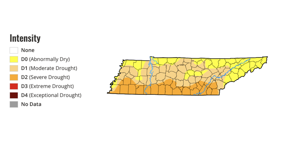
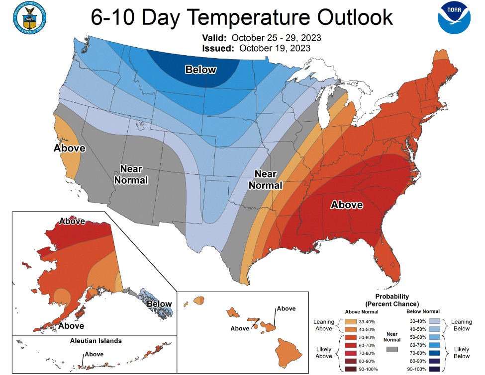
Good afternoon! Showers have generally ended west of I-75, but with wrap around moisture and the proximity of the disturbance pop up isolated showers remain in the Foothills and Smokies. These will continue at times this evening/early tonight, before drier conditions find us Saturday for all. Temperatures will remain on the cooler side of average today, topping out in the low to mid 60s. We'll see a slight warm up tomorrow, in the upper 60s to around 70, before followed by a secondary blast of cooler air Sunday (highs this day in the mid 60s). Winds will also be a bit breezy at times today through Saturday, before slackening late weekend. Turning our attention to something we have highlighted often the past couple of weeks and that's drought. As you can see below, severe drought continues to expand, now encompassing the entire southern third of the state. Meaningful rainfall has been hard to come by, and last night into today was no exception. Most picked up a tenth to a quarter of an inch, but that will do very little in lowering the drought we currently have. Rainfall does not look likely in the next 5 days either, so I expect even worse conditions this time next week. Looking at the longer term outlooks, we appear to close out the month of October on a warmer note. After the active and cooler pattern we have had in the past 10 days, we veer warmer with time. This will be seen as early as next week, with highs trending above average in the low to mid 70s (Tuesday and Wednesday). Precipitation outlooks from the Climate Prediction Center suggest near to slightly above average, so we will keep our fingers crossed. Guidance has an active set up in the pattern around a week out, which could bring us a fair shot at much needed rainfall. Aside from a few isolated showers today, mainly east, most will stay dry through tonight. Cloud cover will thin out with time, resulting in partly cloudy to mostly sunny skies Saturday through at least early next week. Temperatures will be mild tomorrow, take a little dip Sunday with the second dry front, then moderate through mid next week. Enjoy, have a great weekend, and don't forget to send us pictures if you are out and about this weekend- we love to see the Fall colors!
Showers push in tonight into Friday, followed by a second front that will usher in cooler air Sunday. Rainfall amounts will vary, but generally up to half an inch is expected for most. The highest amounts will come for the foothills and Smokies through Saturday morning. High pressure brings the return of dry weather and sunshine Sunday into early next week. Pre-recorded for 5pm weather broadcast
|
Your trusted source for everything weather in East Tennessee.
Social Media
|

