|
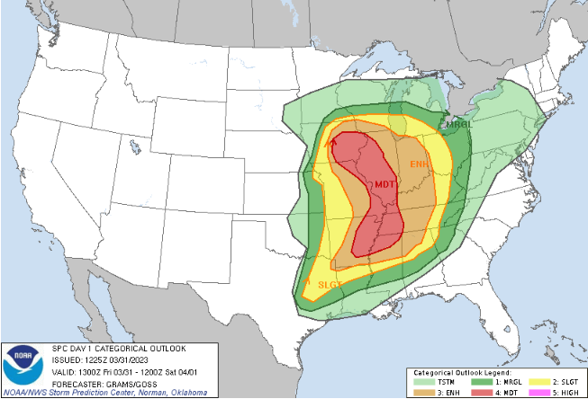
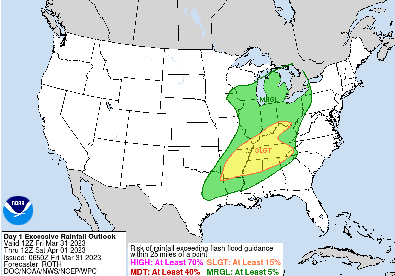
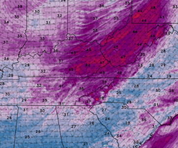
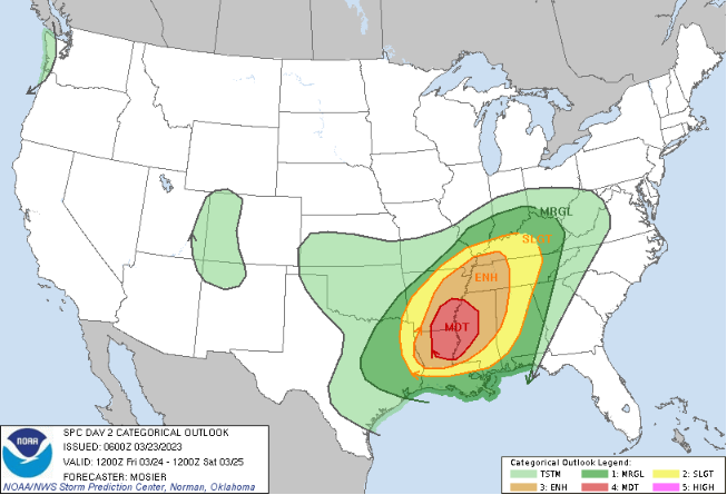
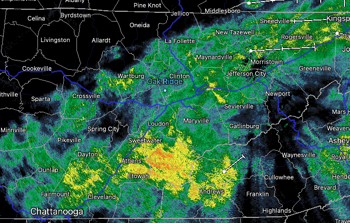
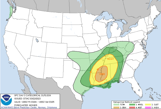
Good morning! Forewarning to be weather aware as we work into the night tonight. A line of storms is expected to work east today, arriving tonight into early Saturday morning. Looking below, the SPC has highlighted a Marginal risk for much of the area, while a slight across the Plateau and southern valley. I would not at all be surprised to see this slight shifted further east given some of the latest guidance, so stay tuned. As far as timing and threats, initial arrival of the front will come between 11 pm and 3 am, working east into Saturday morning. The biggest threat will be damaging wind gusts but an isolated tornado can't be ruled out. To a lesser extent, flash flooding will be possible. Though we have not had a ton of rainfall in the most recent days, strong storms in addition to the on going rainfall this morning could pose concerns. Prepare now, especially if near low water zones and common flash flood points. Lastly, even after the cold front departs, winds/gusts will be strong. A wind advisory has been issued for Saturday as a result, with gusts as high as 50+ mph in some locations. Sustained southwest winds of 15-25 mph are also expected. Bring in and secure any outdoor objects you may have. The biggest take away is to have a way to receive warnings tonight. Strong storms could bring 60+ mph straight line winds along with isolated tornado chances. Be weather aware, know your safe place now, and have multiple ways to receive alerts. Better conditions return by tomorrow afternoon and into Sunday, before shower chances pop back up early next week. Another strong system could even bring storm chances mid week (so stay tuned for updates on this one). Pre-recorded for 5 pm weather broadcast
0 Comments
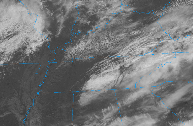
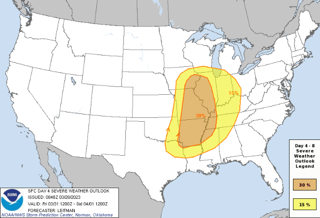
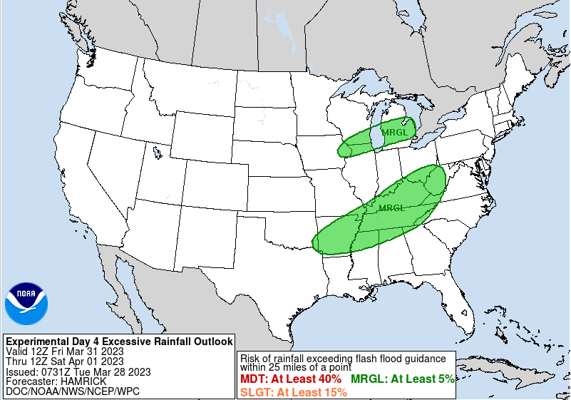
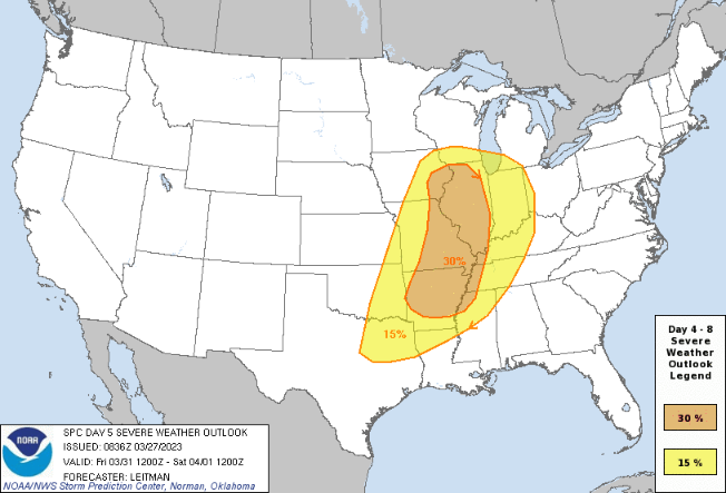
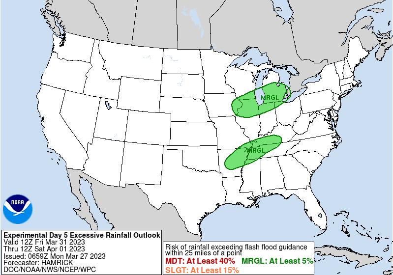
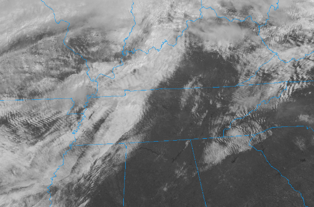
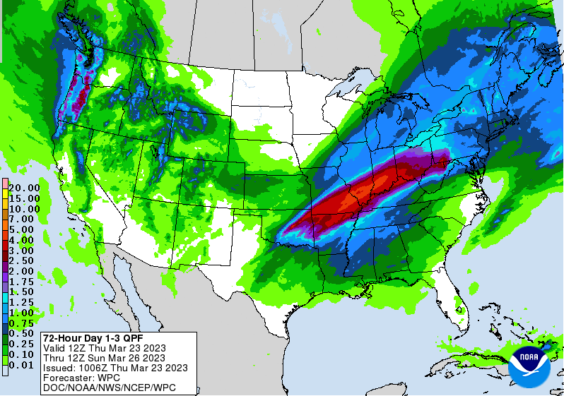
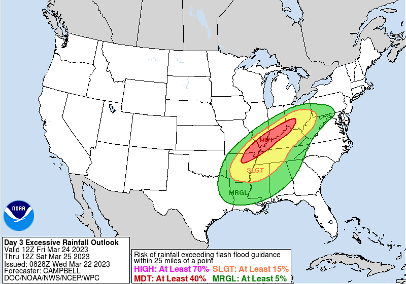
Other than a few light showers to sprinkles today, most have stayed dry but cloudy. Temperatures are cooler as a result, in the 50s now and warming to the low 60s by days end. The good news is clearer skies are in sight. Looking at the latest (12:20 pm) satellite image below, sunny skies prevail across West and portions of Middle Tennessee. This cloud shield will continue march east, allowing for clearing skies overnight into Wednesday. High pressure will then remain in control through Thursday, before a strong area of low pressure glides nearby and brings a renewed threat for showers and storms Friday into Saturday. The SPC has highlighted its thoughts on the severe risk, with a slight chance (and greater) staying just west. That said, we are very likely to be under at least a Marginal risk, with a slight chance seeming favorable for at least the plateau and possibly southern valley. Time will tell, as there remains some uncertainty in the exact timing in larger scale models. Start preparing now if there could be a severe storm or two and what you would do. The WPC has also placed the area under a Marginal flash flooding risk, again for those strong storms and heavy rainfall makers. Friday night into Saturday morning will be the timing for the bulk of activity, good news as far as the lesser severe risk timeframe. Nonetheless, be weather aware Friday night and stay tuned for further updates. That will do it, temperatures tomorrow will fall similar as today with highs in the lower 60s. Thankfully, a warming trend ensues, with highs climbing back into the low and mid 70s by Friday. That said, breezy conditions should be expected both Friday and Saturday with the tightening pressure gradients across the area. Pre-recorded for 5pm weather broadcast
Good afternoon! A beautiful one it is with mostly sunny skies and temperatures ranging in the upper 60s to near 70. We will squeak out a couple of more degrees before days end, topping out in the low 70s across the valley. Generally moving forward we will see a cooling trend, with highs Tuesday in the mid 60s and Wednesday in the low 60s. Not to worry though, as low 60s are our typical average and we will see things warm right back up toward the weekend. Looking below, we are eyeing another storm system late week. Similar to this past storm system, we could see the opportunity for strong to severe storms and an isolated flash flooding threat. There is still a lot of details to smooth out but timing (for us) looks favorable, generally late Friday into early Saturday. Additionally, there could be a low end shot of flash flooding risk. With generally dry or low end rain amounts expected now through Thursday, this is likely very minimal at best. That said, within any strong thunderstorms and over any location that sees repeated activity, the risk can't be entirely ruled out. The break down this week is as follows: High pressure keeps things dry through tomorrow morning, before isolated shower/sprinkle chances find us Tuesday afternoon and evening. Drier conditions then return overnight Tuesday through Thursday with seasonable temperatures during this time. By Friday, a strong area of low pressure will glide north and west of the area, bringing the opportunity for strong storms Friday into Saturday ahead of a cold front. Stay tuned for more details to come. As mentioned, the timing (as of now) looks for favorable for a lesser severe risk but there remains medium spread in guidance solutions. For now, enjoy the generally dry weather over the next few days with highs near to just above average. Don't forget to check out our video forecast below for more details as well. Pre-recorded for 5pm weather broadcast
Showers & storms arrive tonight ahead of a cold front. A few strong storms and heavy downpours leading to isolated flash flooding can't be ruled out. Drier conditions arrive by Saturday afternoon into Sunday, before isolated shower chances return Sunday night through Tuesday. Pre-recorded for 5pm weather broadcast
Good afternoon! It has and will continue to be a pleasant day across East Tennessee, with partly cloudy skies and temperatures warming into the mid 70s. That said, it is a bit breezy out of the southwest with sustained winds between 5 and 15 mph and gusts up to 30 mph. This will be the case again tomorrow and Saturday as well. Looking ahead, we will stay dry tonight into Friday, before a slow moving frontal boundary allows for widespread showers and storms into Friday night. The Storm Prediction Center (below) has stayed consistent in the better severe potential staying further west, as we lose energy into Friday night. That said, the flash flooding risk also remains in place. If we see a few storms into Friday evening/early night, heavier downpours could result. Followed with the line of showers to storms Friday night with the frontal boundary, there could be isolated flash flooding concerns. Both the severe and flash flooding risk are low, but not entirely ruled out. Rainfall amounts will generally range from 0.5-1" with significantly higher amounts across Western Kentucky and the Mid Mississippi Valley. The boundary will stall out here today, dumping rounds of rain across these locations tonight through Friday. We escape this, thankfully, with only a soaking rain in store Friday to Saturday morning. That will do it for today, enjoy the sunshine and Spring conditions. Similar conditions will be in for the start of Friday, before increasingly cloud cover and approaching front bring shower to storm chances late Friday afternoon, evening, and through the overnight. Pre-recorded for 5pm weather broadcast
Good early afternoon! Showers are beginning to taper off from west to east, with most out just in time for the evening commute. That said, cloudy skies will hold on tight, with clearing not arriving until into Thursday. With cloud cover and showers, highs will be chilly today only topping out near the mid 50s. Fortunately, much warmer air is on the way. As this disturbance clears out into tomorrow, our next one takes shape. Looking at the severe potential according to SPC, a Marginal risk is in place. This will be a low end severe risk as the timing comes mainly into Friday night. That said, can't rule out a few strong storms heading through the evening and into the overnight with gusty winds the primary concern. The slightly bigger concern of the hazards will be flooding. Fortunately, there has been a pretty consistent trend that the axis of better precipitation will be north and west of the area. As indicated by the moderate risk across portions of Kentucky, the best of the heavy and repeated rain should miss us. This will be the pivot point of the two fronts and passing low. That said, we are not entirely out of the woods, as heavy downpours in addition to what we see today and leading up to Friday night could create some localized issues. Rainfall amounts Friday afternoon through Saturday morning will vary between 0.5-1". Both hazards: severe & flooding are low chances. Even so, take precautions now as there is that low end risk. As far as the play by play, showers end over the next couple of hours, with clearing skies into Thursday. Dry weather is in the plans for tomorrow, before showers return the later half of the day Friday. The best chances will be just ahead of the front Friday night to early Saturday, before clearing and drying out through the weekend. Shower chances then return Sunday night into early next week. Pre-recorded for 5pm weather broadest
Pre-recorded for 5pm weather broadcast
The Spring season officially begins a little after 5 pm today. Thankfully temperatures will rebound for the first official day (tomorrow) with highs around 60 degrees. Showers edge back in mid week, with the best chances Friday. Pre-recorded for 5pm weather broadcast
|
Your trusted source for everything weather in East Tennessee.
Social Media
|

