|
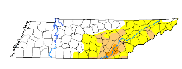
Good news across the board here for east Tennessee, drought conditions have improved greatly from this time last week. If you recall, the Chattanooga area was under an extreme drought, which has now been reduced to a severe drought. Continuous rain through this early afternoon will only help the overall situation. In addition to the diminished drought conditions, we have a dry evening just in time for Trick or Treaters.
Looking at the current surface map, the cold front will push showers toward the east, funneling in much cooler air from the north and west this afternoon. Until then, it will be stormy and windy at times with stronger storms beginning to work in now. Once this cold front pushes through tonight, we will have clearing skies and cooler temperatures into Friday and the weekend. 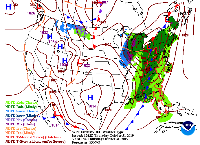 Showers will continue eastward this afternoon and overnight, eventually clearing for Friday. I will emphasize the cooling of temperatures this afternoon, so bundle up this evening if you plan to go out. Showers are expected to move out around 5 o' clock (from west to east) eventually becoming clear overhead by early Friday.  With a strong cold front moving through, the NWS has issued a FREEZE WARNING for east TN until tomorrow morning at 10 am. Be mindful of any crops or vegetation you may have and cover them up tonight. Here is a snip-it of the warning below: 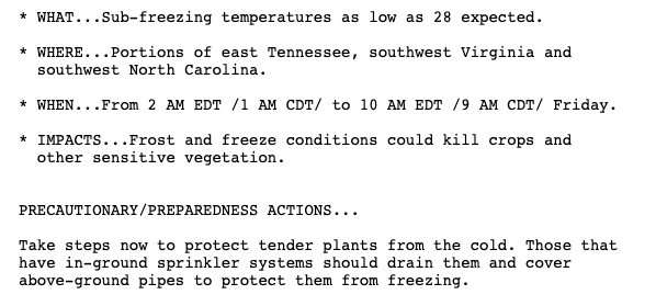 Thats all we have on your Thursday, continue staying weather aware as Anderson, Knox, Campbell, and Union counties JUST went under a Severe Thunderstorm Warning until 11:45 am. We have all the latest on our Social Media @SecretCityWX
0 Comments
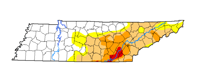
With cooler temperatures already in place (starting the day in the upper 20's and low 30's), we will top out this afternoon in the lower 50's under mostly sunny skies. For those who have already been outside today, you are definitely feeling the difference temperatures wise from this time yesterday. Much of east Tennessee is 30+ degrees cooler thanks to the cold front we had move through. 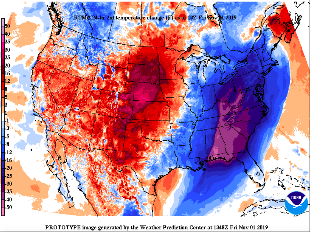 Looking at the surface map below, little changes are expected in the forecast as a high pressure system will lock in dry air and maintain the seasonal conditions. By mid-weekend, a weak cold front will bring temps back down into the lower 50's for high's Sunday, but we will continue staying mostly sunny and dry overhead. 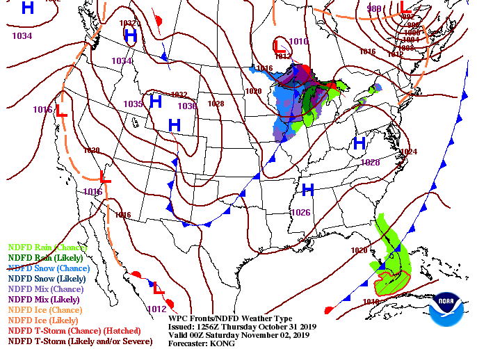 Pairing this with model guidance, there's little to discuss weather-wise other than the cooler air. Dry conditions, cooler temperatures, and sunny skies will stick around this weekend and into early next week. This will make for a perfect weekend to hike, camp, or enjoy any outdoor activities. Don't forget to share your outdoor time with us by sending your pictures to [email protected] or tagging us on social media (@SecretCityWX for both Twitter and Facebook). We, of course, will give full credit to you.  That will wrap up your forecast for the work week, but I hope everyone can enjoy the cooler temperatures and the much needed sun after days of soggy conditions. You can find your full graphical forecast under the "Weekly Forecast" tab above. Have a great weekend! I hope everyone is staying dry today as the latest radar scan shows the showers continuing to stream in from our south and west. These will continue this afternoon leaving high's in the mid to upper 60's. 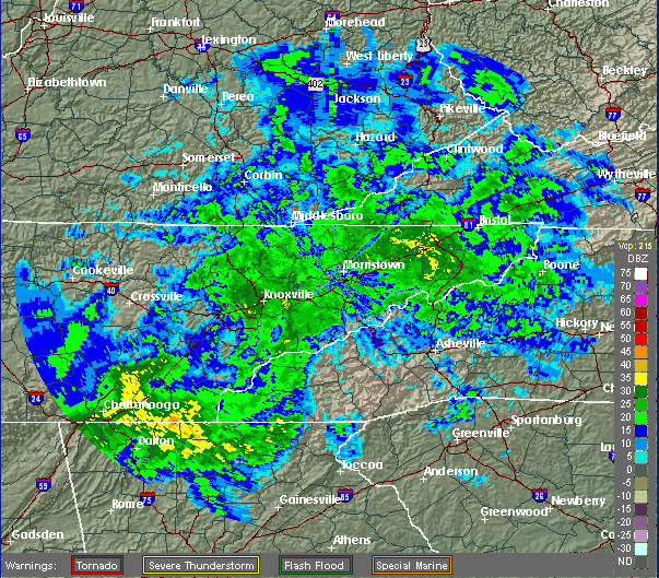 Showers and storms (as we will see tomorrow morning to mid afternoon) will continue all ahead of a cold front to our west. This system is expected to move out just in time for Trick or Treating (around the 5-6 o' clock hour). With the rain moving out, expect much cooler temperatures to move in. Our high temperature tomorrow will actually arrive near lunch (near 70 degrees) and begin decreasing after that. For the afternoon commute tomorrow, expect temperatures in the 50's and decreasing through the night to a low around freezing (32). 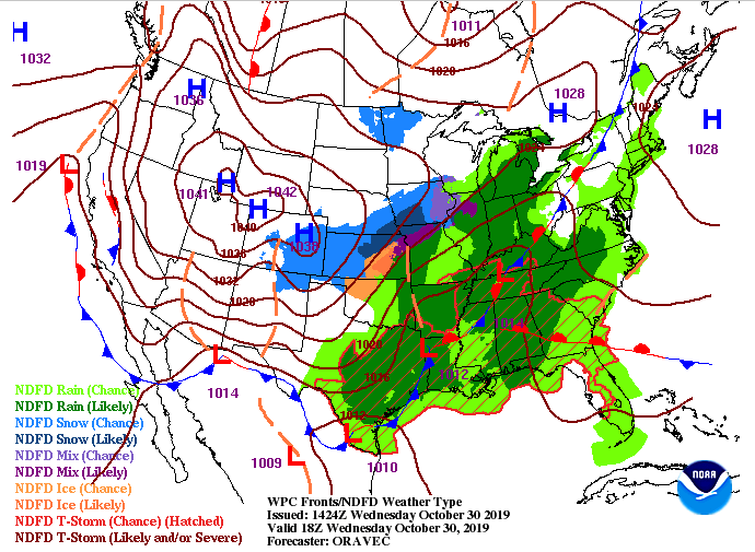 Ahead of the cold front, we are anticipating the chance for some strong to severe weather. The latest SPC (Severe prediction center) convectional outlook shows a marginal risk for much of east TN with NE TN under a slight risk tomorrow. Confidence is very low for an tornado formation, but can't be ruled out entirely. Instead, expect the worst of these storms to be damaging winds between the 9 AM to 1PM range. 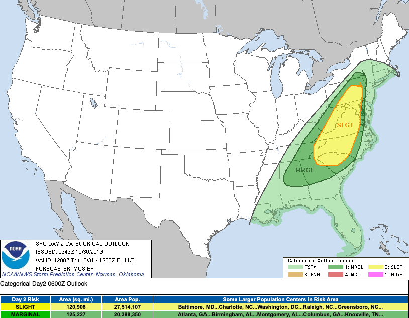 As expected from model guidance, showers and some storms will roll through this afternoon and overnight before the darker shades of color (reds, yellows, oranges) arrive tomorrow mid-morning. Be weather aware for your Thursday as we will have gusty winds throughout the day (around 25 mph), some thunderstorms, and heavy rains at times, as well. The good news is this system will move out just in time for some free candy. Dress accordingly though as we will have decreasing temperatures into the night. 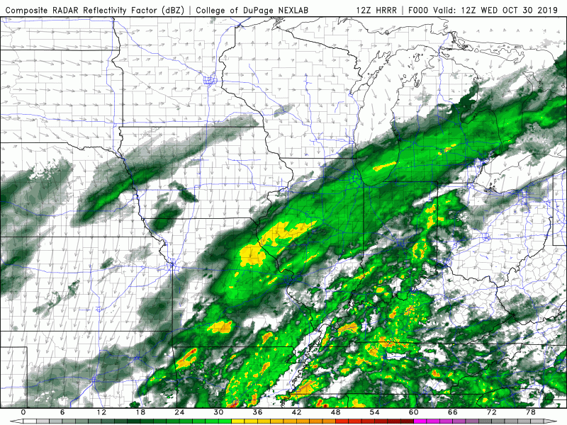 Your full video forecast can be found below. Stay dry today and tomorrow, as it'll continue to be a wet one. Also be weather aware and be sure to check in with us tomorrow morning for the latest on the stronger storms. Have a great day! I hope everyone is enjoying their day thus far. It's going to get wet one the next couple of days thanks to our next system starting to work in this afternoon. Clouds are already beginning to increase from west to east and this will continue overnight as showers work in late morning/early afternoon Wednesday. Much like our last system, these will be light with on and off showers throughout the day Wednesday and Thursday.  Behind these showers expect much cooler temperatures. Friday and this weekend will be in the 50's for high's and 30's for low's. Post cold front, also expect clearing conditions with sunny skies to return Friday and the weekend. (Perfect for hiking or camping) 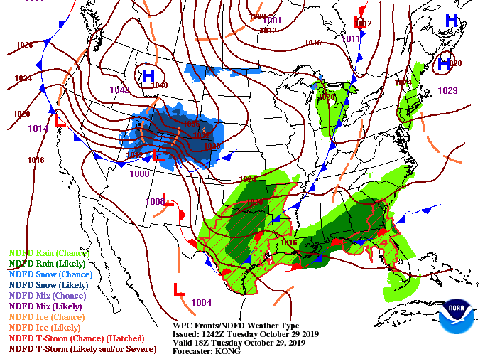 Unfortunately, Halloween will be a rather wet one with showers through much of the day. A rumble of thunder or two can't be ruled out so take the proper precautions if you do encounter one. As of right now, 11 PM looks to be the hour we are shooting for for much of the showers to begin working out leaving skies to clear overnight Thursday. Though it may not be ideal, I am sure many of the kiddos will enjoy a little extra fun with rain overhead during the early trick of treat hours. 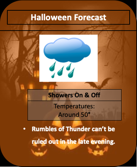 Thats all we have for your Tuesday forecast here, but don't forget your umbrellas out of the door tomorrow, as you'll see those showers begin working in by lunch. We have a gorgeous Monday in store to start the new work week. Mostly sunny skies and high's expected to be in the low to mid 70's. Working into the larger forecast for the week though, changes are coming. Right now we have a high pressure system hanging over head keeping things dry and comfortable. As we work into tomorrow afternoon, cloud cover will increase ahead of a cold front to the west. This will funnel in moisture from our south and west Wednesday and Thursday before clearing out and cooling off Friday and the weekend.  Model guidance suggests an isolated shower is possible tomorrow afternoon in the plateau but the main system won't arrive until Wednesday, caring through Thursday evening. With this next system, we are expecting between an inch to two inches of rainfall. Again, as depressing as it can be, we have been very dry across the state, so all rainfall helps. By Friday morning we will begin clearing out, allowing for a "chilly" end to the work week with high's in the low to mid 50's. Frost will likely be a concern Friday and through the weekend, as low's are expected to be in the low/mid 30's with some in the higher elevations dipping into the upper 20's.  Looking ahead into early November, the CPC (Climate Prediction Center) expects much cooler temperatures (below average) for the first week. In addition, expecting much drier conditions as well. Once the cold front moves through Thursday and into Friday of this week, we will cool down and dry out for the week ahead. 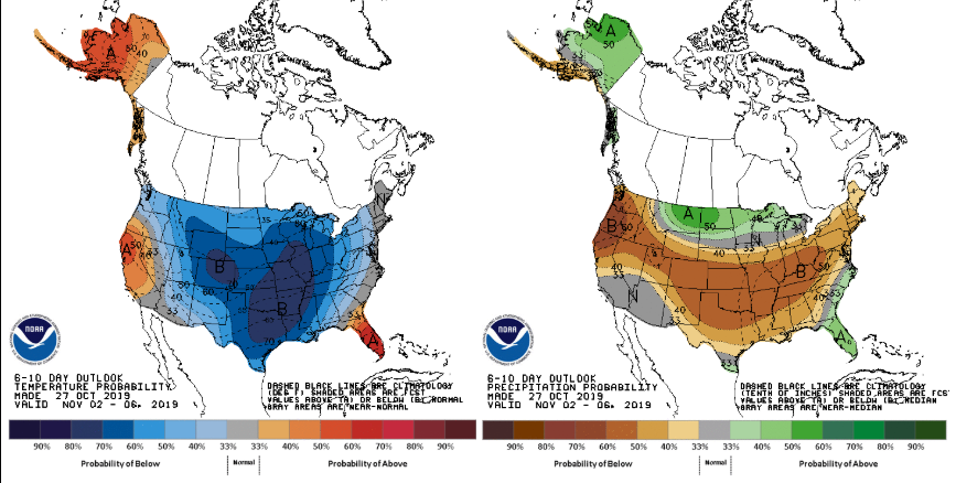 That is all we have for your Monday forecast but be sure to soak up some rays before more rainfall moves in mid-week. Happy Friday to all! Cloud cover worked in overnight allowing for a few showers to work in across the area for the lunch time hour. As we progress into the afternoon these will continue, likely having a wet commute home from work. These showers are streaming in from our south and will continue on and off through early Sunday before a high pressure system clears things out. 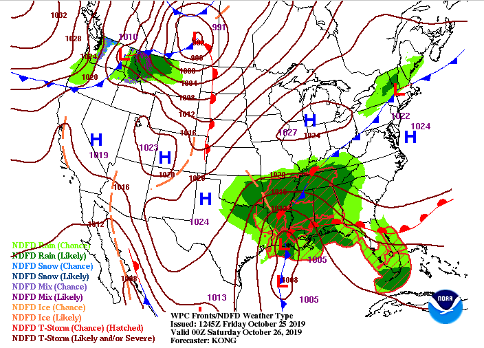 Model guidance continues to keep the bulk of this system west. This may be good news if you have any errands to run or outdoor activities. Showers will continue overnight tonight but by tomorrow afternoon we could see a brief pause from the showers. Into Saturday night, another round from our west will develop and slide through into early Sunday. By Sunday afternoon we will begin clearing out, bringing back those sunny skies and comfortable temperatures. Rain totals through the weekend will be anywhere from 0.5 - 1 for the majority of east TN. The more you head west, the more rainfall is expected. I know many aren't welcoming rain for the weekend, but as we saw from the latest drought monitor, it is still very dry throughout east TN. 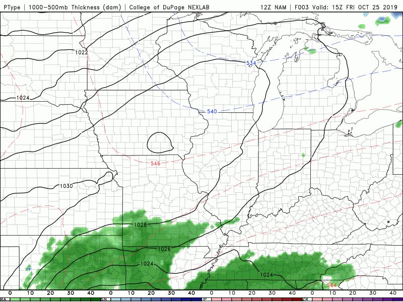 A sneak peak into next week shows cooler temperatures are on the way to close out October. Halloween might be chilly for some with high's Thursday and Friday in the 50's and overnight low's in the lower 30's to upper 20's (for the higher elevations). A cold front mid-week will drop temperatures to close out October and begin November. Side Note: We started October with high's in the 90's and will likely end in the 50's (What a change!) 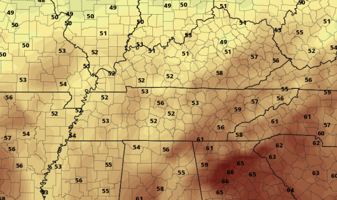 That will wrap up your Friday forecast but stay dry this afternoon and throughout the weekend. We will continue posting on our social media for the latest regarding radar, totals, and any changes in next weeks cold front. Have a good weekend! Good afternoon to everyone! We will have one more beautiful day before showers move in Friday and the weekend. Before I touch on that, take a look at the latest drought monitor map for Tennessee. VERY dry conditions still present in Bradley, Hamilton, and Rhea counties along with much of east TN. Luckily, rainfall will be moving in tomorrow and this weekend, helping combat the dry conditions.
Looking at the current surface map, you can see a cold front beginning to work in from the west. This will arrive tomorrow, cooling temperatures down to a high in the lower 60's. Along with this front, expect showers to move in by tomorrow afternoon. 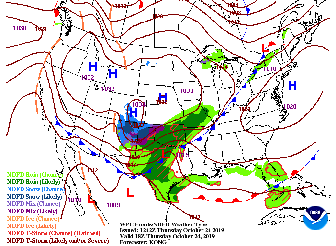 As you can see from the latest model guidance, light showers will move in tomorrow afternoon and become more moderate tomorrow night. These will carry through the day on and off Saturday before slowly moving out the later half of Sunday. Overall rain totals are around the one inch mark with higher totals expected in middle Tennessee. The bulk of rain will ride middle to West TN and push north. Rain totals in these areas could exceed 2 to 2.5 inches through the weekend.  As unfortunate as it is to have a wet and gloomy weekend, we are in need of rainfall as you can see from the drought map. Much cooler temperatures are in the forecast for next week, so stay tuned as we will discuss this in more detail tomorrow. Remember your umbrellas out of the door in the morning, as you will likely encounter rain on your way home from work tomorrow afternoon. The cold front has brought cooler air (up to 12 degrees) into the area since this time yesterday for parts of east TN. Working into this afternoon though, we will warm up to high's in the mid 60's. This will continue into Thursday warming up near average with sunny skies and highs around 70.  There is some changes coming in the forecast though, as a system will develop to our south bringing another round of rain and storms Friday and into the weekend. This will cool things back down into the lower 60's and bring another inch to two inches of rain Friday through Sunday. 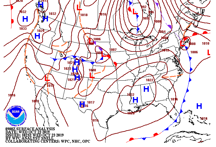 Taking a look at model guidance, we see that system develop in the Gulf moving north into east TN. This will bring us quite a bit of rain (based on the latest data) from 1-3 inches depending on where you are. As we get into tomorrow, I will have a better idea on totals across the region. In addition to rain, snow showers are possible for our friends to the north by early/mid next week. A low to the north early next week will swing through a cold front bringing light snow showers to parts of Kentucky, Indiana, and Ohio. There is a slight chance for some snow showers in the highest of elevations of the Smokies, as well, but we will see as time gets closer. Nonetheless, expect cooler temperatures to work back in early to mid next week with overnight low's dropping in the the 30's and even 20's for the higher elevations.  Thats all we have for your Wednesday but go out and enjoy the fall conditions and check back with us tomorrow for the latest development Friday and into the weekend. (Side Note: This weekend looks wet and gloomy so get all of your outdoor errands done while its beautiful) We cleared out quickly this morning allowing for sunny skies and cooling temperatures to move in. Much of the same is in the forecast for tomorrow with high's to be in the mid 60's and mostly sunny. A high pressure system to our south will keep things dry the next several days until scattered showers arrive Friday.  For those in the higher elevations (Plateau, Smokies, and north TN into south KY) be sure to cover any valuable plants, as frost is possible both tonight and tomorrow night. Dew points (Seen below) will continue decreasing overnight allowing for a cool & crisp evening and dry Thursday. Low's for the valley are expected to be around 40 degrees with cooler low's in the higher elevation (mid to upper 30's). 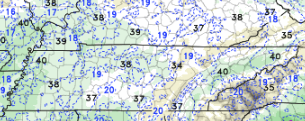 A few residual showers (associated with the cloud cover) have begun moving out of NE TN early this afternoon, leaving sunny skies behind. This will continue being the case for the next few days as the high pressure system to our south will lock in drier air. Friday and into the weekend, this will break down as another system will bring scattered shower potential and cooler temperatures.  Go out and enjoy the next few days of beautiful sunny skies and temperatures in the 60's. You can find a full graphical forecast under the "Weekly Forecast" tab, as well as our video forecast below. What a gloomy start to the new work week with fog across the area. It has begun lifting, but clouds are working in from the west. For this afternoon, we will be looking at high's in the mid 70's and mostly cloudy. 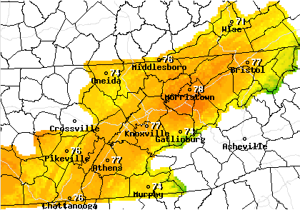 To get a better idea of what is going on, a parent low to the north will extend a cold front out, providing showers and storms tonight and into early Tuesday. Cooler air will also begin backing in from the north allowing highs in the 60's both Tuesday and Wednesday before we begin warming back up to near average temperatures, Thursday. 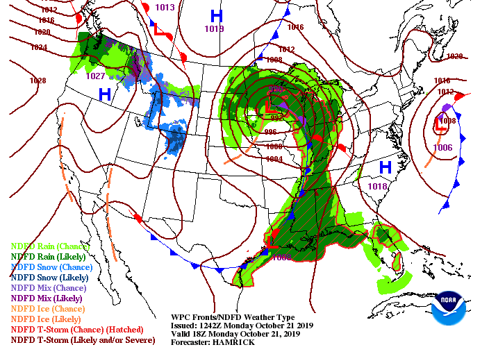 This snip-it at midnight tonight shows the cold front still off to the west. Ahead of it, showers and storms will move through into the early hours of Tuesday. Anticipate cooler temperatures back in the 60's both Tuesday and Wednesday and low's back in the low to mid 40's each evening. 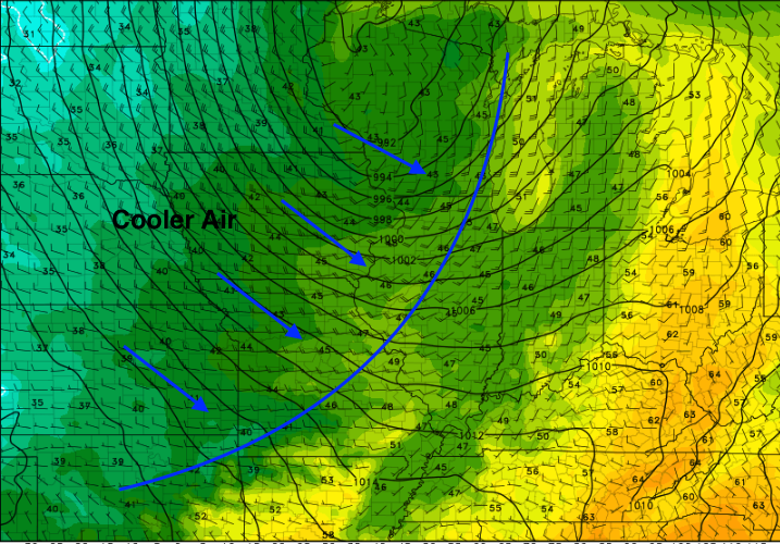 Model guidance depicts the showers/storms overnight tonight. With this system arriving overnight, it lessons the potential for any severe development, meaning good sleeping weather is expected. Nonetheless, any severe development will likely occur in the Plateau before the system weakens as it moves east. Overall rain totals tonight will be between half an inch to an inch. Higher totals are possible in thunderstorms, but generally, 0.5-1 is anticipated. This will help the overall drought we have been dealing with, but are still in need of more rain to correct the issue. 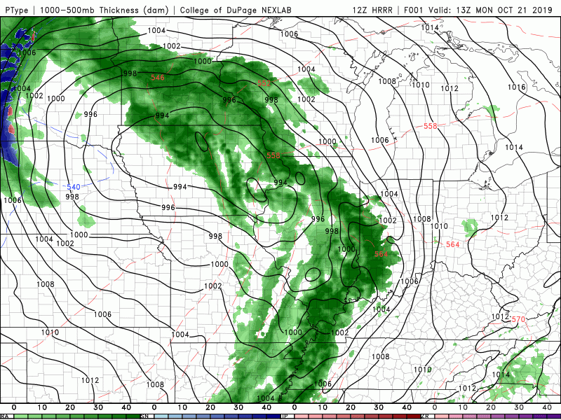 Expect clearing skies Tuesday with high's in the mid 60's by the afternoon. Thats a wrap for your Monday forecast, but be sure to stay up to date on our Twitter: @SecretCityWx for the latest updates on tonight's showers and storms. |