|
The latest radar scan shows a more impressive swath of snow than what is actually going on. A few light flurries are continuing to fall but no accumulation is expected here in the valley. Temperatures are beginning to climb (with day time heating) so snow will transition to rain. 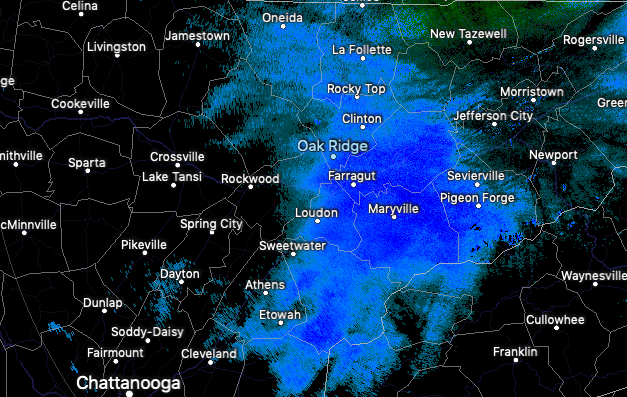 This system will continue to work through today before sunnier skies and warmer temperatures find their way back this weekend. Unfortunately, changes arrive by Monday as heavy showers work through much of early next week. 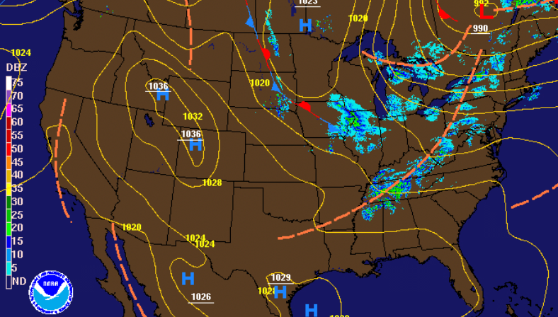 Model guidance shows snow to rain this afternoon then a flip back to snow showers overnight. Early reports show upwards of an inch in the Plateau this morning but I anticipate much of this to melt this afternoon. As we work overnight, another round of snow is possible providing an addition half inch to the Plateau and 1-3" for the Smokies. We could see a dusting on grassy and elevated surfaces, otherwise no accumulation is expected in the valley. The BIG story comes early next week with rainfall expected Monday through early Thursday.  Looking at early totals, east Tennessee can expect between 3" and 5" of rainfall for the first half of next week. As we have seen in January & February, flooding can quickly become a concern so stay up to date for the latest. As of now showers will arrive Monday with heavier showers and storms into Tuesday and Wednesday. We look to finally clear back out by Thursday afternoon, but as I said, flooding is definitely something on our radar. 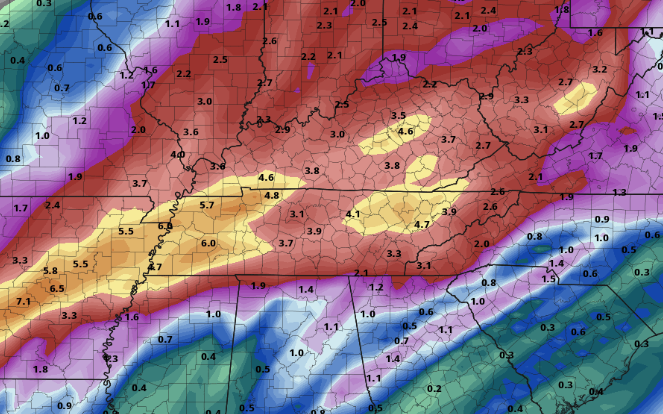 That wraps it up for today! Let us know what's going on in your area by sending us an email, message, or tagging us on social media. A beautiful weekend is ahead so be sure to enjoy that before lots of rainfall returns early next week.
1 Comment
Cloud cover continues to decrease this afternoon opening up the skies to lots of sunshine. As we work ahead, a system just to the north and west will arrive by the morning hours tomorrow. We will start in the form of snow showers but quickly transition to rain as temperatures warm above freezing. By Saturday, a high pressure system works in drying things out and warming things up. Sunday looks to be the most ideal day for outdoor activities as high's will be near 60 with mostly sunny skies overhead.   With this system being a quick mover and temperatures warming into the day, totals will be very minimal. For the Valley, expect mainly flurries with upwards of a dusting possible on grassy and elevated surfaces. Working into the Plateau, up to half an inch is possible for the higher elevations. Keep in mind any accumulation that does occur will quickly be washed away with rain and temps in the 40's during the day time hours. Be careful Saturday morning if you have plans as roads could be slick in spots from patchy black ice. 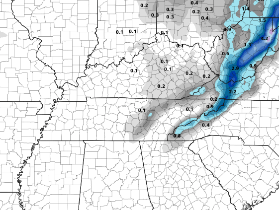 Enjoy the sunshine today before a mix of snow and rain return for Friday. If you can make it through tomorrow, a beautiful weekend is ahead with sunny skies and warming temperatures. Good afternoon! So far this morning we have stayed mostly cloudy but changes are quickly on the way. Showers just to the west will begin working in the next hour or so bringing much cooler air in behind. Looking at the future temperatures by 3pm, we'll be in the low to mid 40's. Along with decreasing temperatures this afternoon, expect a breezy west wind between 10-15 mph. Bundle up for the evening commute as wind chills could be in the mid 30's at times.  The latest surface map isn't too impressive with a weak line of showers we'll see this afternoon followed by a cold front. Showers will stay light before transitioning to light snow showers/flurries overnight.  Model guidance shows the transition taking place around midnight and into the early morning hours. The good news is accumulations aren't expected here in the valley, so morning commute impacts will be very limited. Working ahead, we'll stay dry Thursday before another round of scattered showers to snow showers arrive Friday. Again, limited accumulations and impacts associated. Saturday we will begin to clear up by the afternoon with sunnier skies and warmer temperatures for Sunday.  Be sure, if you haven't already, to have the winter coats handy. Temperatures in the lower 40's and winds between 10-15 mph will make things feel in the mid 30's by the evening commute. I hope you are enjoying your Tuesday so far! A very Spring-like day is ahead with temperatures into the lower 60's and broken cloud cover. Working ahead, showers are expected to arrive by the mid-morning hours tomorrow and continue into the afternoon. On the back-side of this system a cold front will provide much cooler air to end the work week.  Future radar shows showers moving in by the mid-morning hours Wednesday. As we get into the afternoon, a cold front will work through decreasing temperatures. This model has the transition to snow taking place a bit earlier into the day than what I am thinking. Temperatures will remain above freezing into the evening hours (here in the valley) keeping things all rain. Once we get into the overnight hours, a few snow showers/flurries are possible here in the valley, but no impacts or accumulation is expected. As for the higher elevations, the Foothills and Plateau, minor accumulations and little impacts are expected Thursday morning.  Looking ahead into early March, the CPC (Climate Prediction Center) has a trend in warmer temperatures. This graphic is for the first week of March with a 50% chance or higher of above average temperatures. For the time being though, keep the winter coats handy as high's in the lower 40's will stick around Thursday and into the weekend. 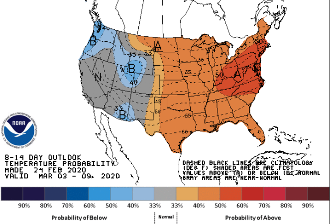 Enjoy the Spring-like feel we have today because colder air is once again on the way. Don't forget the umbrellas either as showers work in tomorrow followed by cold air, breezy conditions, and scattered snow showers. We'll close out the last week of February very similar to this past week. Showers and fair temperatures will be the main headline early week before a shot of cold air and scattered snow showers arrive late Wednesday and into Thursday. As for today, showers will increase this afternoon and overnight before clearing out for much of Tuesday. High's today will be near 50 with temperatures tomorrow in the lower 60's. 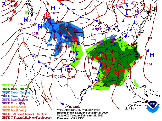 As for the future radar, moderate showers arrive this afternoon and continue overnight. By Tuesday morning, most showers should be to the east with cloudy skies for the day. For Wednesday, another system arrives bringing showers and the potential for snow showers on the tail-end. Just like this past week, the timing of cold air and how much precipitation is associated will dictate snow outlooks. For the time being, stay focused on the rain and cold air to follow with very limited accumulation expected across the region.  Though heavier showers are expected to arrive this afternoon and evening, flooding concerns remain out of the discussion as we push into Tuesday. Overall amounts look to be upwards of an inch before drier air works in tomorrow. A secondary system works in for Wednesday providing another half inch before sunnier skies and cooler air work in Friday and the weekend. 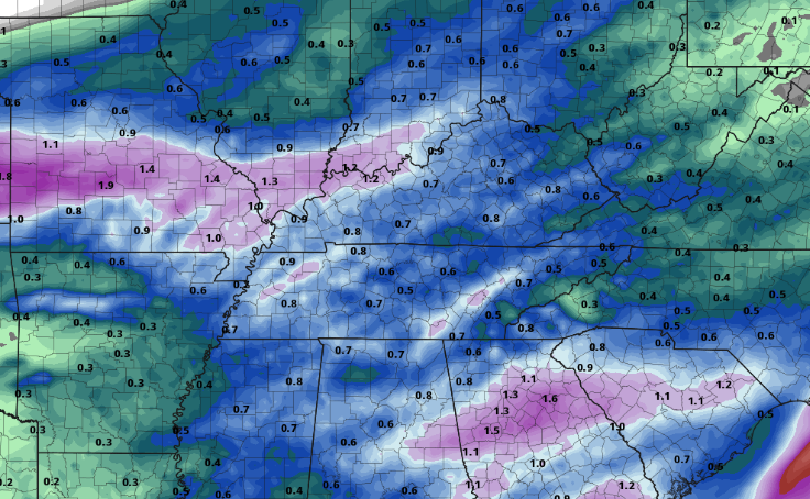 With another active pattern expected this week, be sure to tune in for updates here and on social media. We will continue to eye any snow chances this week, but for now, stay dry this afternoon. Sunny skies have returned for Friday but cooler continues to stick around. Luckily, warmer air just to the west will work in by tomorrow afternoon leaving high's in the low to mid 50's.  Thanks to a high pressure system, we will stay sunny and dry the next couple of days. This would be a great weekend to go out and enjoy the outdoors as temperatures will be seasonable with sunny skies overhead. 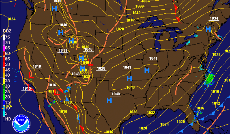 As the latest surface map depicted, a high pressure system will keep things peaceful the next couple of days. Unfortunately, showers return by early next week. Cloud cover will build Sunday afternoon with scattered showers working in overnight and throughout the day Monday. Temperatures will stay fair but colder air will once again tail this system bringing high's in the low 40's by mid to late week.  That's all we have for you today but go out and enjoy the outdoors if you get a chance and don't forget to share your pictures with us. Have a good weekend! Rain has been the main story this morning for much of the valley with light accumulating snow in the Plateau and Smokies. Working into this afternoon, a surge of colder air is expected to arrive helping transition some of the rain showers to mix and light snow. 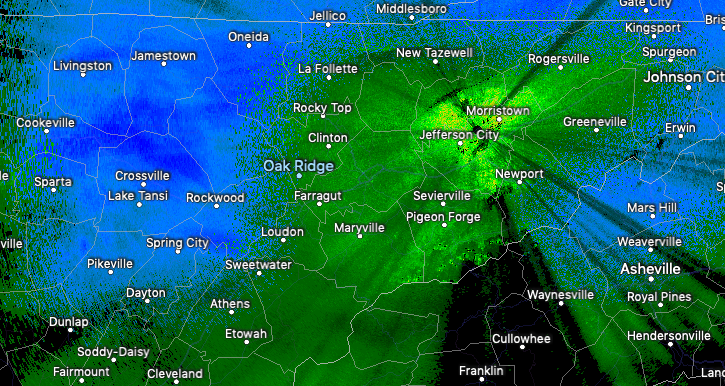 Based on the latest observed temperatures versus model guidance suggested temperatures, we have dialed back accumulation outlooks for the Valley. Currently we are hanging around 37 degrees; a bit too warm for snow at the surface. Depending on when colder air surges in, we could see upwards of an inch in the valley or stay with more of a wintry mix this afternoon. As for the southern valley, rain will be the main story throughout the day but light snowfall this afternoon (with colder air) could provide a few tenths of an inch. For the remainder of the area, the forecast stays on track with 1-3" for the Plateau and 2-4" for the Foothills and Smokies. 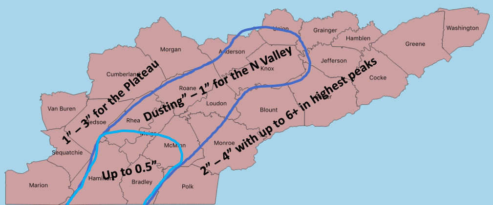 Pushing into this evening, remnant wintry mix and snow showers continues to slide east. A high pressure system will work in from the north, clearing things out for Friday. Sunny skies will stick around Friday and into the weekend with temperatures gradually warming each day. 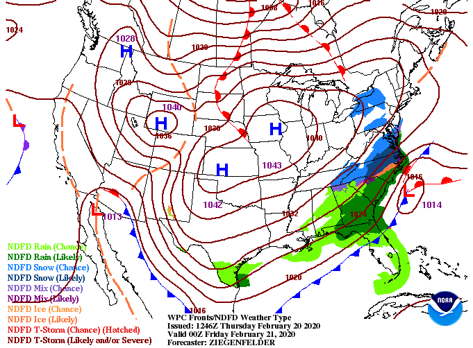 Looking at the latest short-term model guidance, we see that surge of colder air arrive by late morning to early afternoon. Depending on how cold this air actually gets will depend on the precipitation type we receive. As of the current observed data, I am leaning toward mostly rain to mixing but snow is still possible (especially the northern valley). 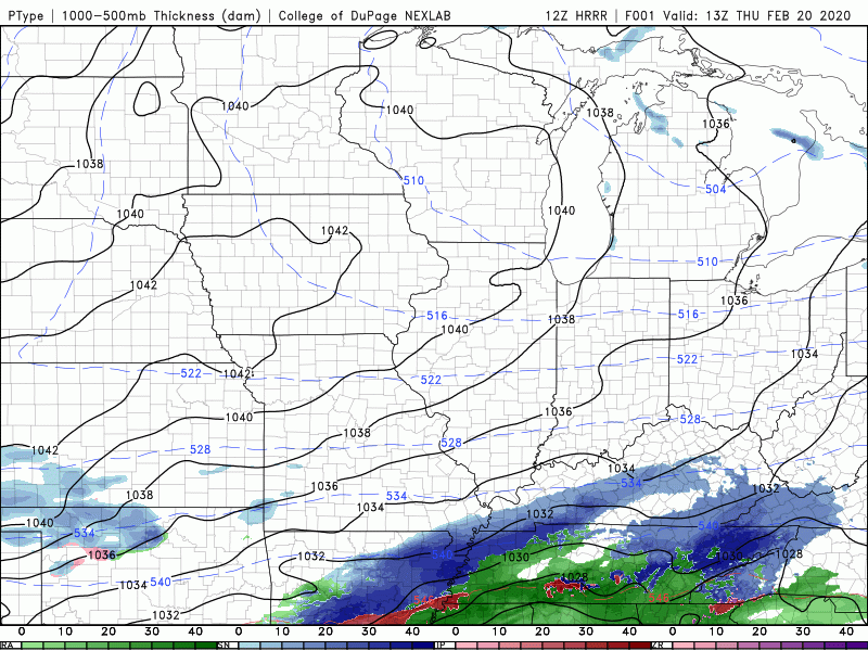 It is important to note the impacts from this system will be minimal with any accumulation staying primarily to grassy and elevated surfaces. Let us know on social media what you are seeing throughout today and we'll continue to keep you updated on the latest! Good afternoon! Sunshine will begin funneling in this afternoon keeping temperatures somewhat comfortable in the lower 50's. Looking ahead, many questions are still out there on the idea of snow. 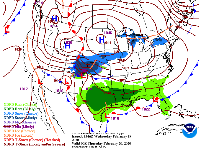 Model data is having trouble pinpointing this next event. To give you an idea, these are the outputs from model to model: NAM: gives the valley an aggressive 3-4 inches GFS: Up to half an inch in the valley RAP: No snowfall ECMWF: Up to half an inch As you can tell from a few of the model's above, there is lots of disagreeance. The biggest factor in determining snowfall will be temperatures. Models are in sync we'll start the morning with all rain but by the early afternoon, a transition will begin taking place. The timing of this cold air advecting in, how cold it will make the lower level of the atmosphere, and how much moisture will still be around are all questionable. We will continue to closely monitor the latest this afternoon, overnight, and early into Thursday.  Based on the latest data, here are the totals broken down by topographic region: Plateau: upwards of half an inch with upwards of an inch for the southern Plateau Valley: Up to half an inch Smokies: 1-3" with 2-4" likely in the higher elevations Again, I will emphasize the variability within the data which plays a roll in the forecast. Changes are likely, so continue to check in with us here and on social media as we will provide updates throughout the day and into Thursday. As for impacts, they will be minimal with any accumulation mainly sticking to grassy and elevated surface. 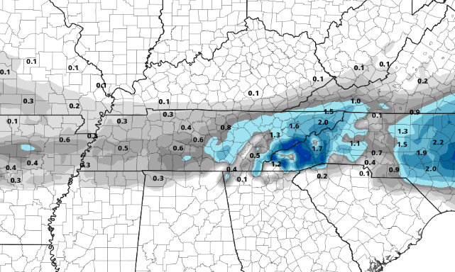 Enjoy the sunnier skies to close out the day today and keep in mind rain to snow showers are possible tomorrow. Scattered showers continue to work through today so be careful on wet roads. A few rounds of heavier showers and rumbles of thunder are possible this afternoon as a cold front draws near.  Pushing into Wednesday, showers will work out by the morning hours allowing for some clearing in the afternoon. Temperatures will stay cool in the 40's much of the day with pockets of sunshine likely in the PM hours. Looking ahead, a system to the south will funnel in moisture Thursday before we clear back out Friday and Saturday. 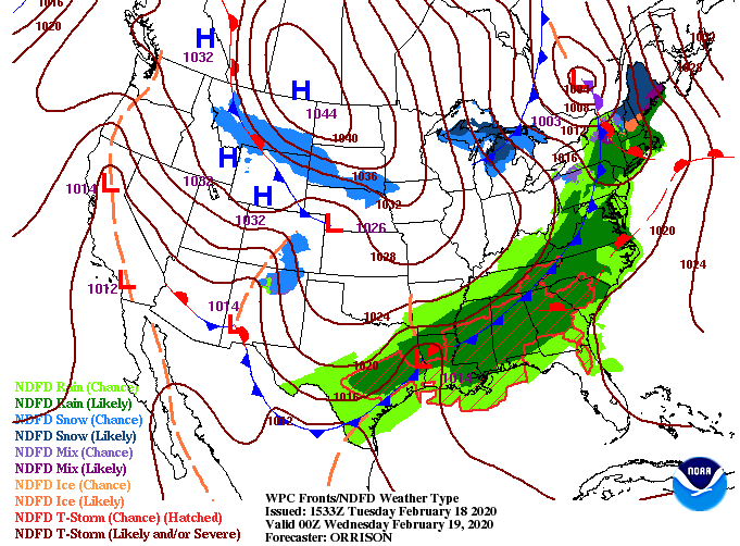 The latest trend in many of the models is for of a more northern track of the system Thursday. This is something we'll be watching through today as snow could be a hazard. Because this trend is relatively fresh (only in the latest two runs), I am hesitant on providing a snow totals forecast of this morning. I think given the early details snow is something to consider but mainly in the higher elevations. Temperatures will play the biggest role as the latest data suggests above freezing through much the day (AKA rain). We will continue to keep a close eye on the track of this system as well as the timing and impacts of the cold air associated. As of now, little impacts are expected for the valley but continue checking in for the latest details. 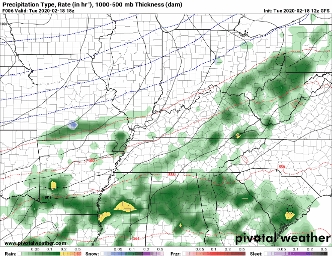 If you haven't already, be sure to check out this year's 2020 East Tennessee Almanac found at SecretCityWeather.com/AlmanacDownload. As for the forecast ahead, stay dry and warm the next few days. We started the morning with partly cloudy skies fir the north half of east TN but cloud cover is quickly on the way. Clouds are expected to continue working in this afternoon with high's near 60 degrees.  The latest surface map shows our next weather maker for the day tomorrow. Showers will arrive in the mid morning hours and continue throughout the day. On the tail-end, a cold front will bring much cooler temperatures Thursday and Friday with sunnier skies as well. 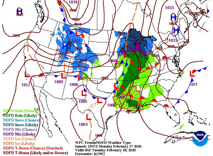 Looking into what the models are suggesting, scattered showers are to arrive in the morning hours and continue throughout the day. The good news is flooding will not be a concern as this will be a one day event of light to moderate showers. Expect to pick up between half an inch to an inch before cooler air and sunnier skies return. 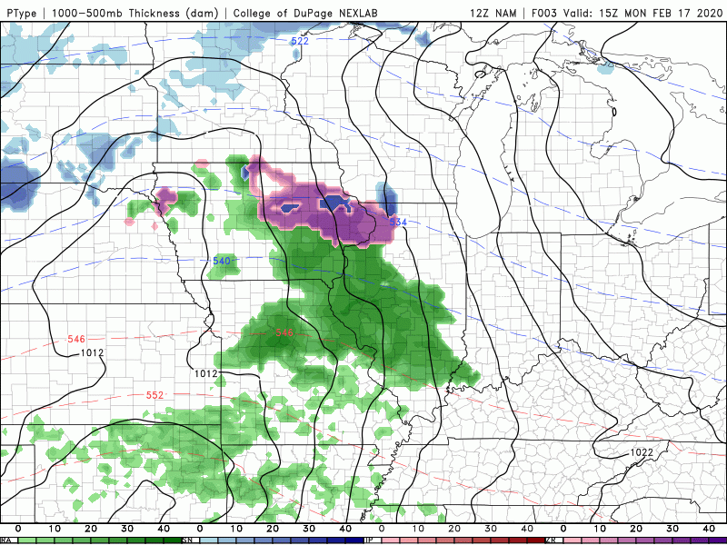 ANNOUNCEMENT: Secret City Weather has officially released this year's Almanac and can be found at SecretCityWeather.com/AlmanacDownload or by clicking the link (button) below. This is a FREE Almanac featuring temperature trends, precipitation, growing seasons, GDD, and much more! Download it today and let us know what you think!  That will wrap it up for the start of the new work week but I wish everyone a great President's Day and stay dry as we work into Tuesday. |