|
I hope you remembered your coat this morning! Take a look below at the changes to the eastern half of the US today. We are 20 to 25 degrees colder today than we were this time yesterday. 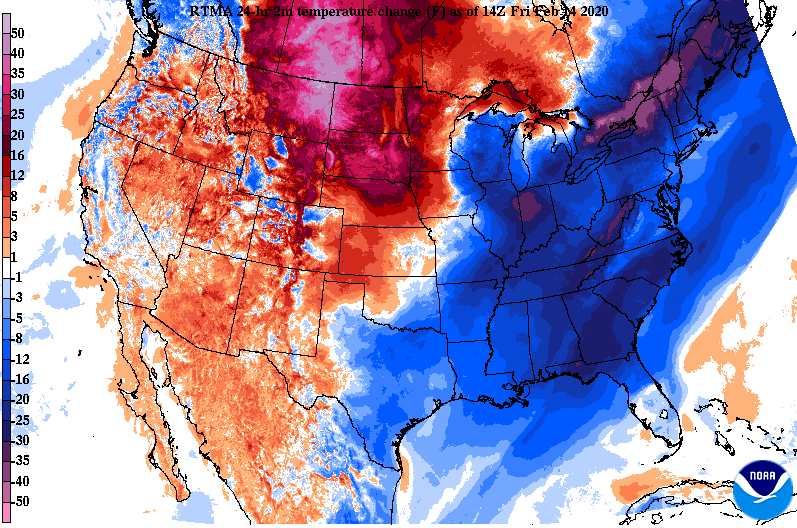 A high pressure system will lock in dry air the next couple of days with temperatures slowly increasing as well. This weekend we'll stay in the 50's with 60's returning by early next week. 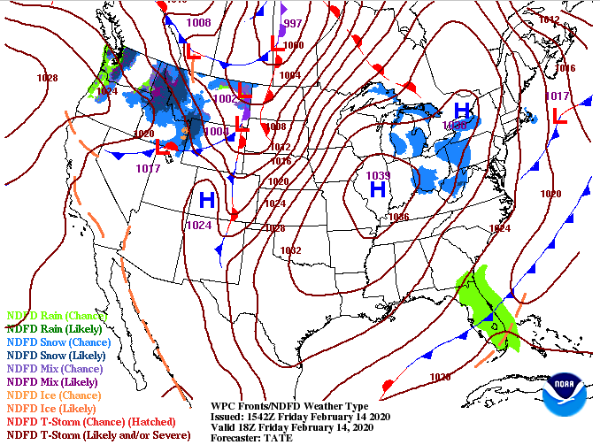 Looking at model guidance, there's little to discuss (thankfully) the next couple of days. As we get into Sunday, cloud cover builds. A chance for an isolated shower or two is possible Sunday evening, otherwise we will stay mostly cloudy. By Monday, scattered showers will work in with a better chance of rain overnight and throughout the day Tuesday.  That will conclude todays forecast so go out and enjoy these lovely conditions. I also want to remind you that this year's East Tennessee Almanac will be available for download on Monday this next week. You can find the page here: SecretCityWeather.com/AlmanacDownload
0 Comments
I hope you remembered your coats this morning! Falling temperatures throughout today will lead to temps in the low to mid 40's by the evening commute hours. Looking below, the cold front is starting to work in from the west and temperatures are beginning to fall (currently 49 here at the office). 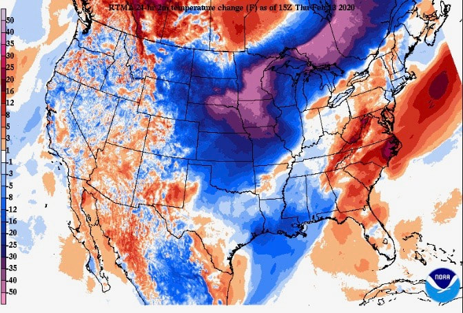 Looking ahead, MUCH better news with sunny skies back in the discussion tomorrow and the weekend. A high pressure system just to the north and west will begin to shift through keeping things dry for much of the eastern US. A warming trend will follow as well with temperatures back into the 50's this weekend. 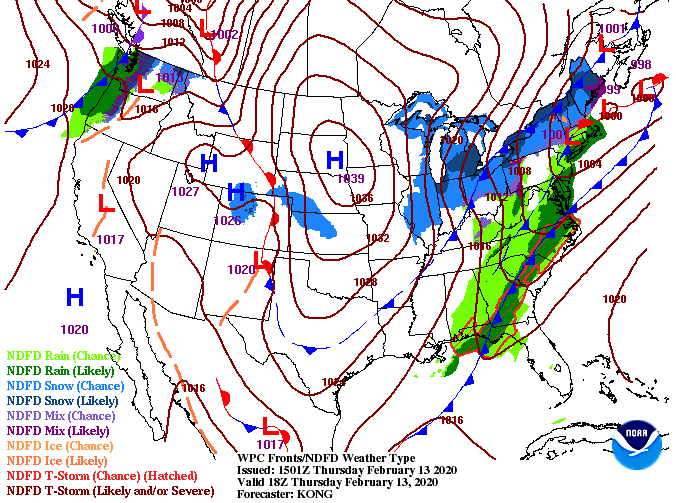 As depicted by the surface map, a high pressure system will keep things worry free the next few days. Cold and dry air Friday will lead to average temperatures Saturday and Sunday. By Sunday evening a system to the north brings the chance for isolated showers with better chances by Monday night.  Enjoy the much needed string of dry days ahead and don't forget your coats tomorrow! Happy hump day! Showers have stayed at bay so far today but a few scattered showers are possible this afternoon. Looking at the surface map below, the main system is just to our west. We'll see heavy showers and storms overnight before MUCH needed drier air works in Friday and the weekend. 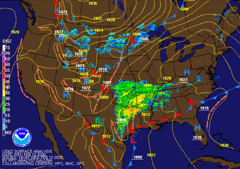 It is important to note the SPC has a slight risk of severe weather tonight across middle TN, Chattanooga, and parts of the central valley. The main threat with these storms will be damaging winds but isolated spin up is possible as well. Be weather aware tonight as heavy rains can create flashing flooding and heavy winds can easy topple over trees. In addition to the severe potential, we are under a flash flood watch until 7am tomorrow. 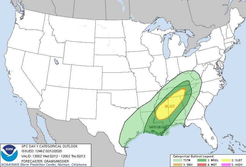 As you can see, model guidance suggests some scattered showers this afternoon otherwise we'll stay mostly cloudy. Working overnight tonight and early into Thursday, a strong line of showers and storms will work through bringing heavy downpours and gusty winds. Expect showers to end entirely by the mid-morning hours tomorrow with cooler air to follow. A cold front will decrease temperatures throughout the day, so bundle up! In addition to the cold front, expect breezy conditions as well with gusts up to 20 mph. 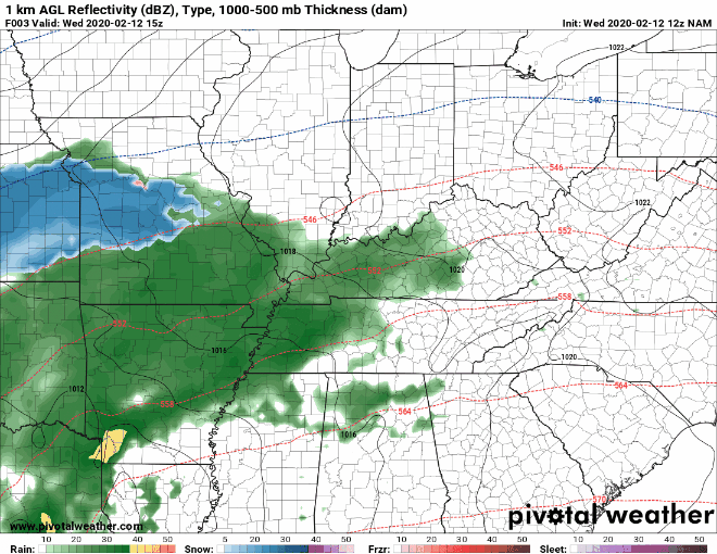 Rain totals with this next system are around the one inch mark for east TN with locally higher amounts possible in heavier cells. With an already saturated ground and the chance for heavy rain, flash flooding can be a concern overnight. 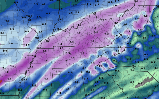 I know more rain isn't something we want to hear but much better weather follows Friday and the weekend. Stay weather aware and safe tonight and check back in for updates! Good afternoon! I have some good news for today as we'll stay mostly dry through the afternoon and overnight hours. As we work into Wednesday, showers work back in. The outlook from the SPC remains much of the same with a slight risk for the Plateau and middle TN and marginal risk for east TN. The main threat will be damaging winds but isolated spin up is possible as well. With the heavy rains we have received the past few days, be weary of trees overturning in strong wind situations. Lots of rain has contributed to loose soil and, in some cases, mudslides. 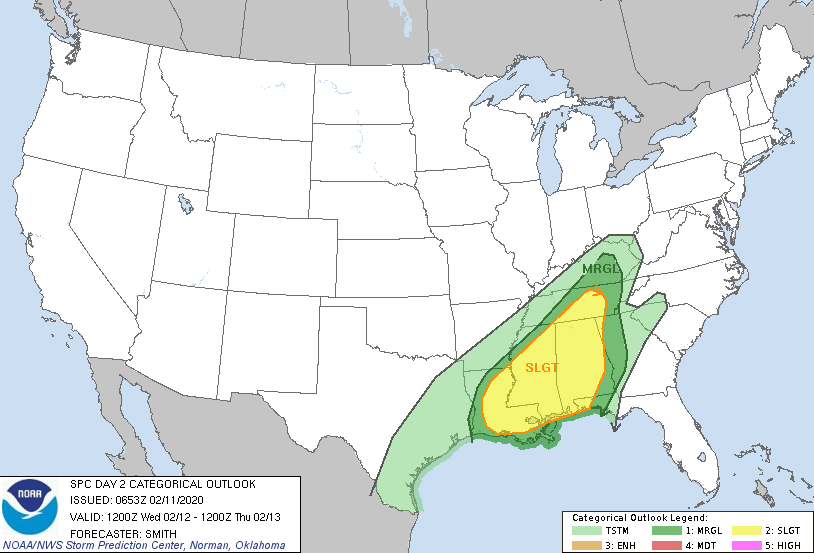 Looking ahead, we will stay mostly cloudy this afternoon and overnight before scattered showers arrive tomorrow morning. Strong to severe storms will move through in the evening and overnight hours ahead of a cold front. Once this front moves through, expect clearing to take place and temperatures to drop throughout the day Thursday. Friday and Saturday look to be beautiful with sunny skies overhead. 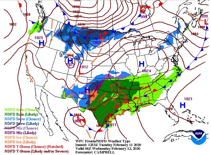 Looking at model guidance, the last of the showers are moving through the Smokies now. This will leave the remainder of today with mostly cloudy skies and mild temperatures. Scattered showers are expected to arrive Wednesday morning and continue into the afternoon. By the evening and overnight hours, a heavy line of showers and storms (strong to severe) will work in. As we get into Thursday morning, shower chances decrease and a cold front will slide through. With the cold front, expect clearing to take place overhead and temperatures to fall throughout the day. That will set up a sunny end to the work week on Friday with temperatures around 40 degrees for the high.  Enjoy a break from the showers this afternoon because more are on the way for tomorrow. As of noon today we have picked up 2.65" of rainfall and more is on the way for Wednesday. Stay weather aware tomorrow, especially the evening and overnight hours. Lastly, stay up to date with us on Twitter & Facebook for the latest. With a very active week ahead, I'll jump straight into it. With a system working through, expecting to dump up to 3+ inches of rainfall today and tomorrow, flash flooding is a major concern. The latest from the WPC outlines a moderate (20% - 50%) risk of flash flooding. Heavier showers are expected overnight tonight as a warm front moves through, so flooding is likely tomorrow morning. Be sure to check in with local officials on what to do if flooding occurs in your area. 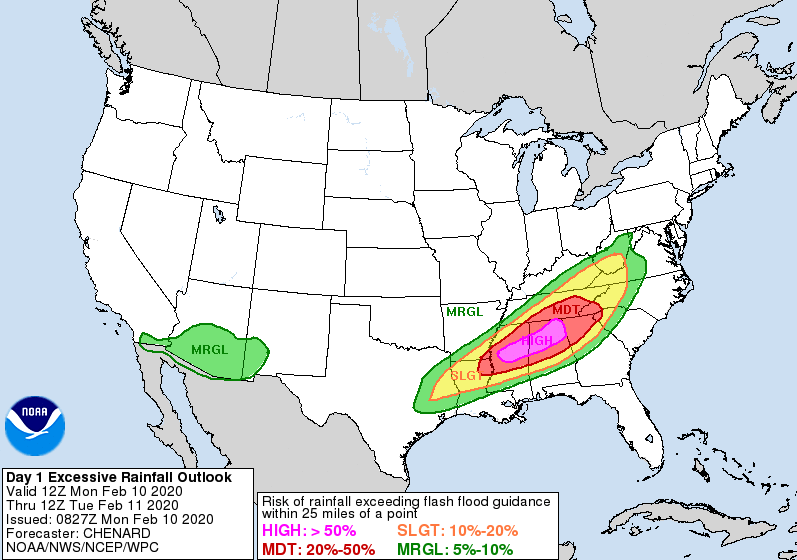 Looking at the latest surface map, this week looks almost identical to last week. Expect rounds of systems bringing heavy rains, severe possibilities, and cold air to cap it all off. Below, a warm front will work through overnight providing lots of rainfall (1-2 inches) into Tuesday morning. Another system from the southwest will bring strong to severe showers/storms Wednesday and early Thursday before cooler and drier air moves in late Thursday and for the day Friday. 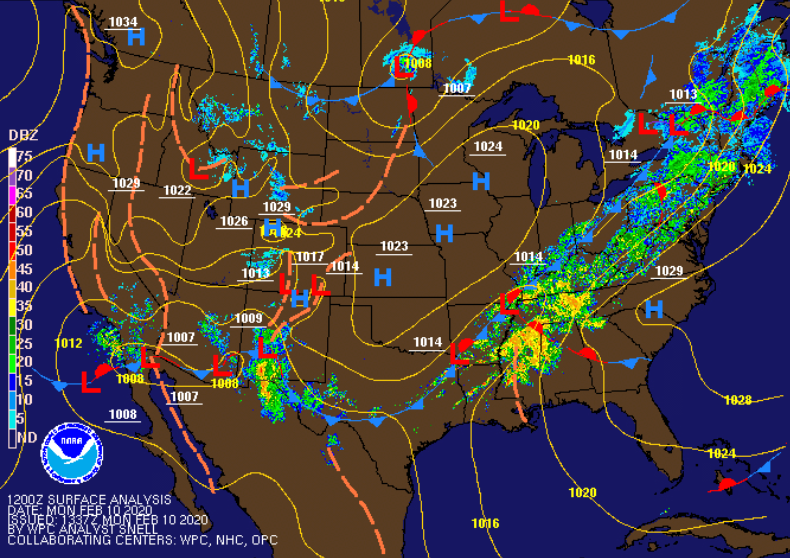 Model guidance shows the moderate to heavy showers expected overnight tonight. Scattered showers are likely into the early afternoon hours as a weak cold front works through. We will get a brief pause Tuesday night with mostly cloudy skies overhead before another system arrives Wednesday. This secondary system will bring the chance for strong to severe storms. Clearing will begin Thursday afternoon with sunny skies and cool temperatures to close the work week off on Friday.  The outlook for Wednesday shows middle to eastern TN under a slight risk for severe weather (2/5). Given the heavy rains expected today and tomorrow, flash flooding will remain a concern Wednesday as well. Damaging winds, heavy downpours, and isolated tornadoes are all possible Wednesday afternoon. 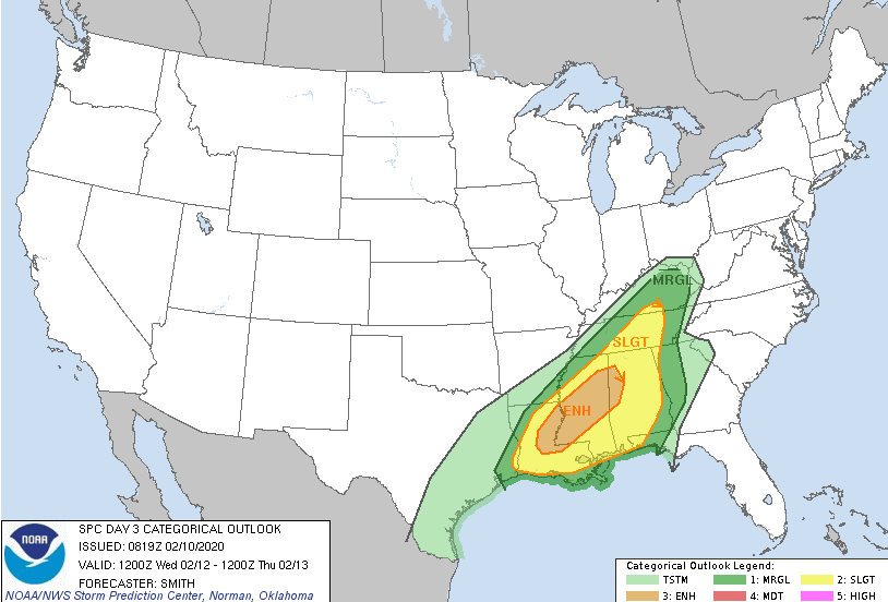 As of noon today we have picked up over 0.85" of rainfall here at the office and more is on the way. I mentioned 3+ inches of rainfall is possible through tomorrow, but up to 7" is possible for the Chattanooga area through this week. Here in the central valley, 3-5 inches is a realistic outlook but locally higher amounts are possible. Regardless of where you are at, flash flooding is a major concern this week, along with the potential for severe weather (Wednesday). Stay active with us here at Secret City Weather as well as with local officials and the NWS. 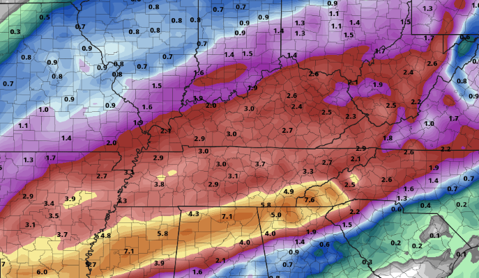 For more details, view our daily video forecast below or email us at SecretCityWx@aol.com. If you could help us out with weather reports this week, that would be greatly appreciated it! Simply tag or email us a picture (with location mentioned) or let us know what you are seeing and where. We will relay that information to local officials, the NWS, and other viewers in the area. Stay safe, do your best to stay dry, and stay up to date with us this week. Good afternoon! I hope you are staying warm outside today. Looking below, we have cooled off nearly 30 degrees across the area since this time yesterday. Temperatures will remain cold today with high's in the mid to upper 30's and winds out of the west between 5 and 15 mph. A few remnant show showers/flurries also remain possible, eventually moving out overnight. 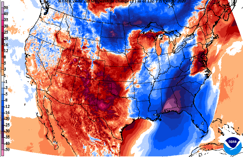 Looking ahead, remnant snow showers are possible today before we dry out a bit overnight. Another round of light scattered showers and snow showers is possible tomorrow before sunny skies and warmer temperatures return on Sunday. 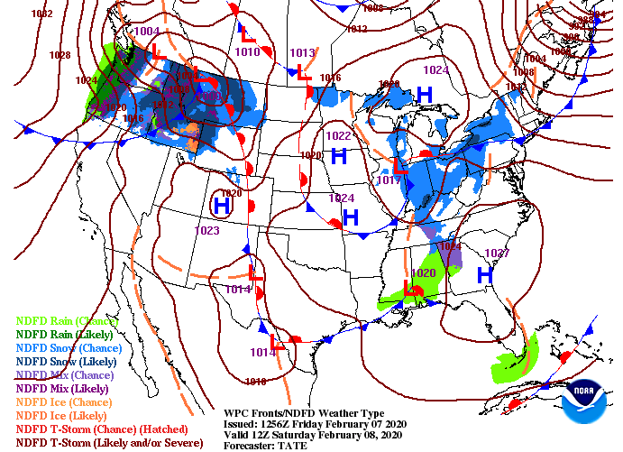 Model guidance shows the light snow showers that will likely continue throughout the day. As we get into tomorrow, another set of scattered showers and snow showers is possible before we clear out overnight. Sunday will be clear with partly sunny skies and high's in the mid 50's. Unfortunately, rain returns Monday and early next week.  Looking at the latest data Monday through Friday of next week, an additional 2-4 inches is possible. On a positive note, we will have a chance to dry out some this weekend before those showers return. Nonetheless, be weary of flooding once again next week as 2-4 inches of rainfall on an already saturated surface can lead to rising waters quickly. 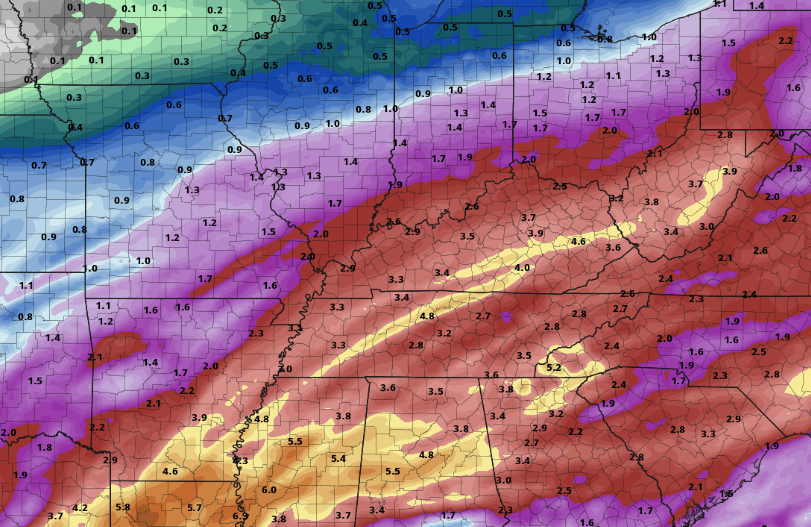 If you have any reports or pictures you'd like to send in, you may do so via Twitter/Facebook (@SecretCityWx). Stay warm today and tomorrow, and enjoy those sunnier skies, before rain moves back in Monday. Reports of flooding throughout east TN continue to pour in. If you have any reports or pictures you'd like to share, tag us on social media @SecretCityWx or email us at SecretCityWx@aol.com. We will give full credit to you. Looking below, much cooler air is on the way. In fact, temperatures have already begun dropping as a cold front starts to work in. Breezy conditions will also accompany this front. Typically, breezy conditions and cold air are not a good mix, but for this case, the wind will help in drying out wet surfaces. With temperatures near freezing tonight in the valley, icing in the higher elevations could become an issue. 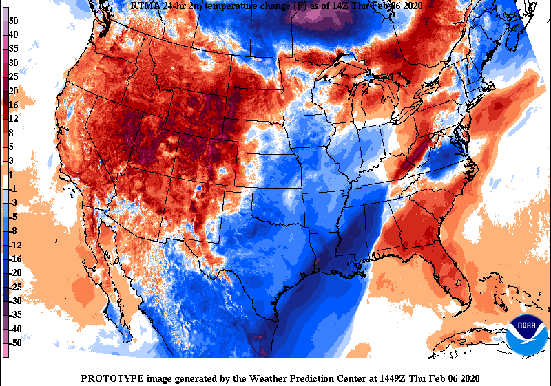 The latest surface map shows there is an end in sight. Remnant light showers and snow showers will move out tomorrow morning, leaving the remainder of the day mostly cloudy. Another round of showers are possible Saturday morning before much needed clearing takes place into Sunday. Unfortunately, this active pattern continues with more showers Monday and early next week. 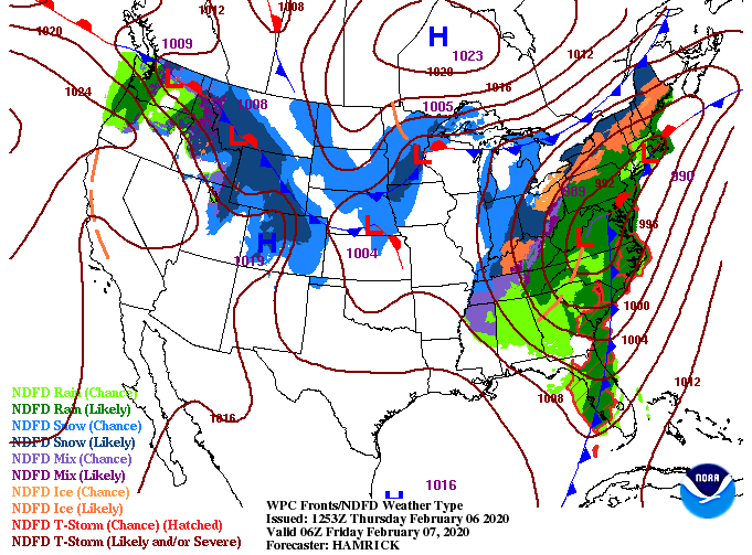 The short term high resolution model (below) depicts the likely outcome over the next 24-hours. As colder air works in, snow showers/flurries will likely move through. Though no accumulation is expected here in the valley, the Plateau and Smokies could see some "white stuff" Friday morning. 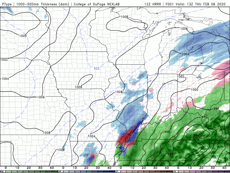 As always, stay up to date with us via Twitter/Facebook (@SecretCityWx) and be careful if you're on the roadways today and tomorrow. I hope you are staying dry outside! Showers are set to continue this afternoon and Thursday. The latest radar scan shows moderate showers working from the southwest. Unfortunately, we won't begin drying out until Friday afternoon and then again on Sunday. 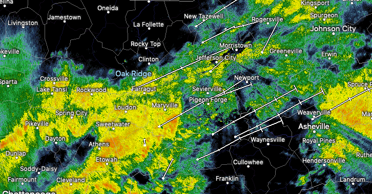 Looking below, the second low pressure system has worked in and will bring heavier showers and storms overnight and into tomorrow. Though the severe threat is low, be weary of damaging winds and flash flooding. The southern Valley and southern Plateau could feel the worst of the showers/storms tonight, but as I said, severe potential remains low. The main concern for east TN, now through Friday, will be flash flooding. NWS Morristown has issued an active Flash Flood Watch until 1am Friday morning. Something to take notice of is the colder air moving in tomorrow afternoon. High's for the day will come early, leaving temps in the low to mid 50's by the evening commute hours. 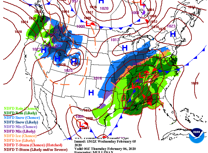 As anticipated, showers will continue into Thursday with the chance for snow showers overnight Thursday and early into Friday. As of the latest data, little impacts will be associated here in the valley. With warm ground temperatures and only a brief period of snow potential, expect little to no accumulation. Another round of showers & snow potential return Saturday morning but this one will move through much quicker.  As of noon today, the office here has picked up over an inch of rainfall. Looking ahead, another 2+ inches is expected tonight and through Thursday. Flash flooding and flooding in general can quickly become a major hazard so remain weather aware if you live in low-lying areas. 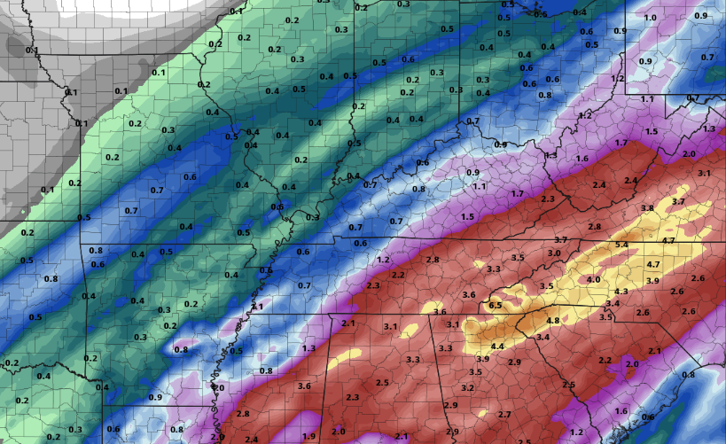 As always, we will continue to update you on the latest regarding the heavy rainfall, limited severe threat, and minimal snow potential the next couple of days. Until then, stay safe and dry as we work into Thursday! Steady showers continue for much of east TN this afternoon with little changes in the near forecast. Accessing the surface map below, rain continues today and tomorrow with a secondary system moving through Wednesday night and Thursday. 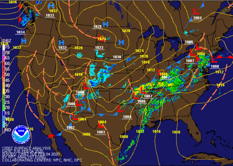 With all of the rain we have received so far and expect into the day tomorrow, this secondary system raises the potential for flooding/flash flooding. This next surface low will arrive late Wednesday and into early Thursday dumping heavy rains across an already saturated ground. The latest from the WPC shows a slight risk for flash flooding Wednesday morning to Thursday morning. Be weary of low lying and flood prone areas as water levels are expected to rise the next couple of days. 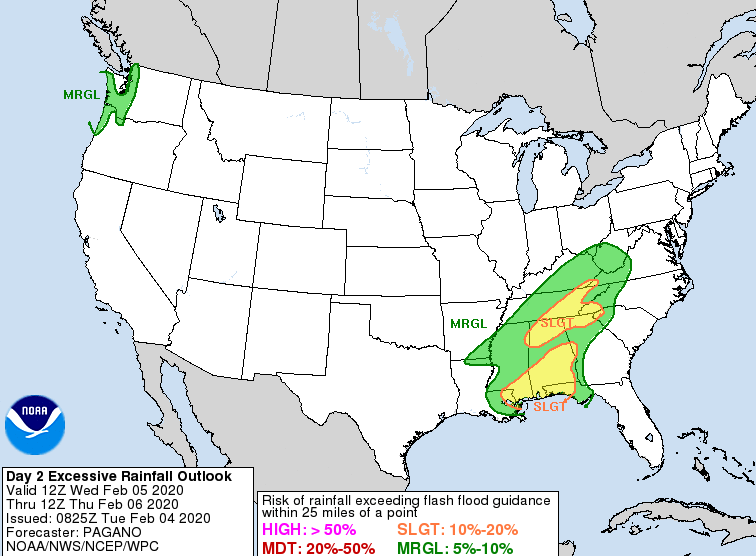 Looking at model guidance, showers will continue this afternoon and overnight. Working into the later part of Wednesday and early into Thursday, the next round of heavier showers and storms arrives. Our best chance for a dry day comes Friday with mostly cloudy skies and cool temperatures expected. Scattered showers move back in Saturday before drier conditions return Sunday. 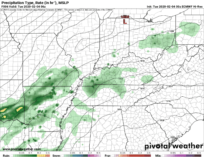 Keep the umbrellas handy the next couple of days; more rain is on the way. For more details, watch our daily discussion below: I hope everyone had a good weekend! In case you missed it, Punxsutawney Phil did NOT see his shadow; meaning an early Spring is predicted. Though his predictions the past decade have only been 40% accurate, we are definitely starting off right with high's today in the mid to upper 60's.  Washington Post Looking ahead, our next weather makers are just to the west. Showers will arrive early tomorrow and work through until Friday when cooler air arrives. 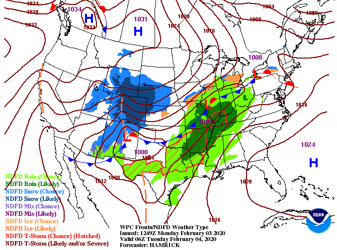 Model guidance suggests showers to begin working in tomorrow morning and continuing through Wednesday. A secondary low will provide heavier showers and storms Wednesday night and Thursday before cooler air follows for Friday. Mostly cloudy skies Friday will lead to scattered showers Saturday, and eventually, much needed sunnier skies for Sunday.  With rain likely much of the work week, rain totals will be high. Though the severe threat is low, be weary of flash flooding. A couple of inches is expected to fall Tuesday and Wednesday and with heavier showers/storms into Thursday, water can accumulate quickly. 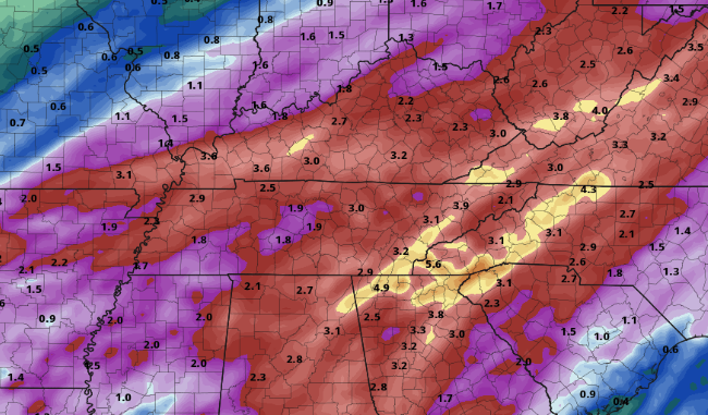 That will conclude today's forecast but keep the umbrellas handy, lots of rain is on the way. |