|
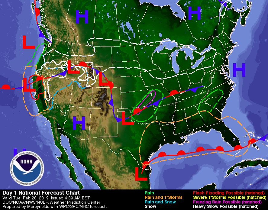
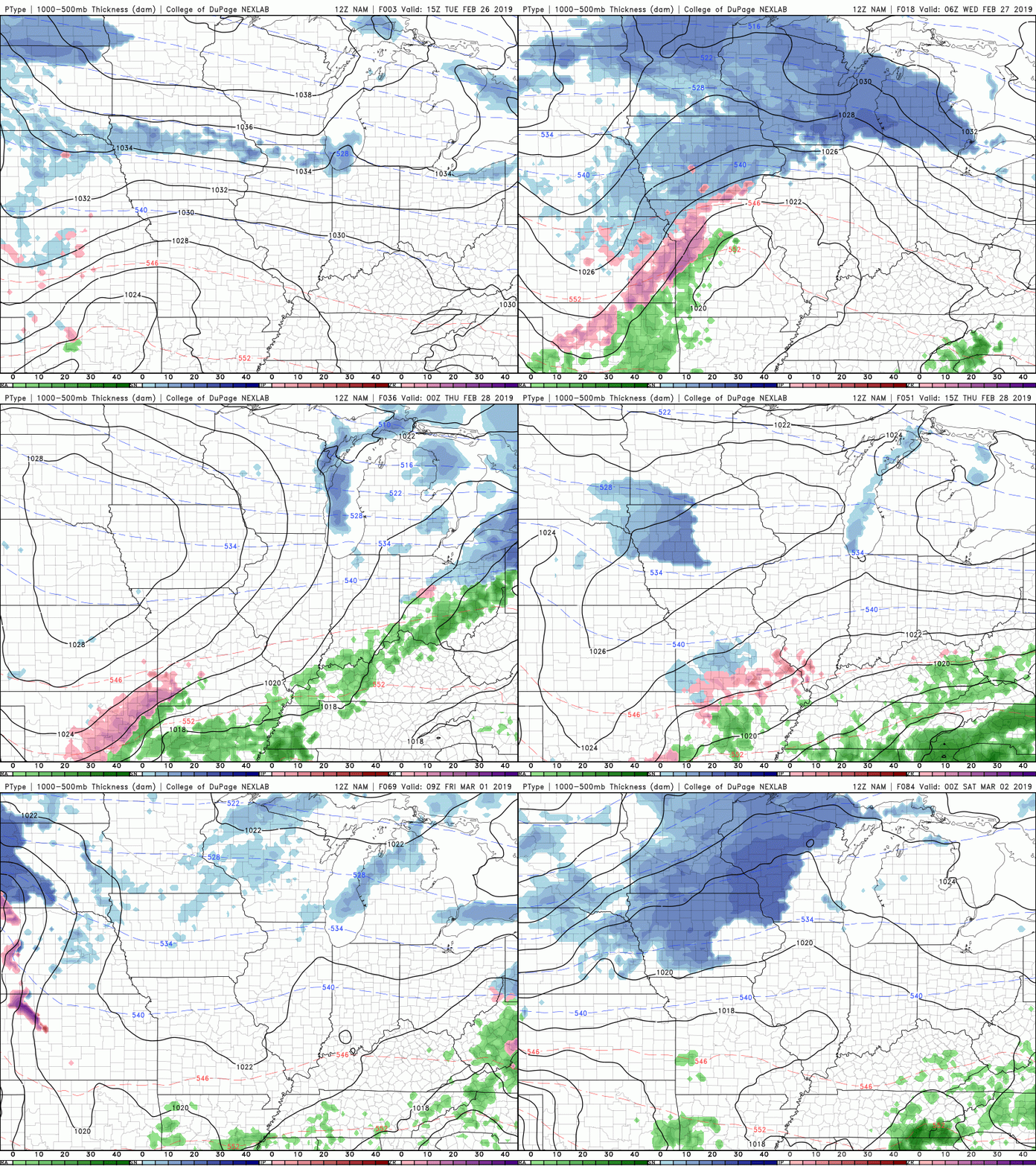
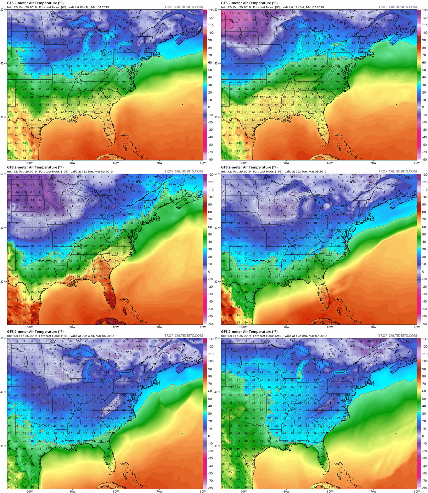
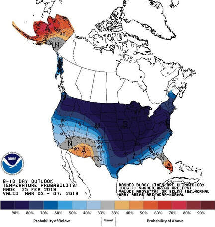
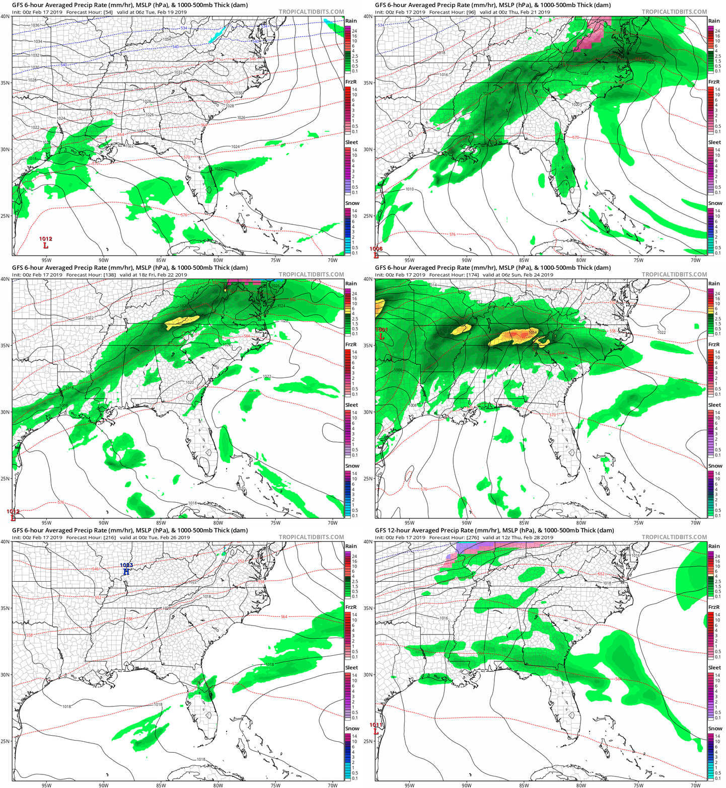
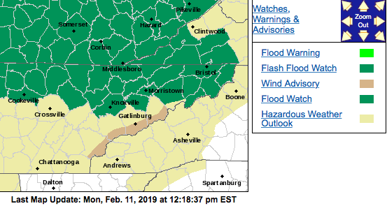
Enjoy the warmer temperatures and sunny skies while it lasts before the rain once again finds its way back to our region. To start, Anderson county is under a Flood Warning until 4:15 pm today. This is due to the flooding going on near and downstream of the dams. TVA has been working nonstop to combat the high waters received from all the rain the past few weeks. Residents in these regions or in areas of continued flooded, please remain cautious. On the bright side, today looks to be much like yesterday but with warmer temperatures. High's are expected to top out near 60 today with sunny skies. The reason for the sunny skies can be given to the high pressure system that has begun moving out of the southeast and off the coast. This has provided us with some much needed sun and spring like temperatures. Sadly, these will not stick around much longer as a low is making its way toward our region and bringing with it the chance of rain. As you can see above, we will remain mostly dry until late Wednesday and into the day Thursday. This is when our next round of showers is expected to arrive. For your Thursday, you can expect rain to be scattered throughout the day. Rain amounts of a tenth to two tenths of an inch are possible with this system Wednesday night to Friday morning. For remainder of the week and weekend, expect scattered showers with much cooler temperatures into early next week. Late Saturday into the day Sunday looks to be the time with the most amount of rain. Amounts of up to half an inch are possible Saturday into Sunday night. The general outlook for the beginning of March looks to be much below average. Starting this weekend, much cooler temperatures will be moving into east TN and most of the entire US for at least the first week to week and a half of March. To coincide with the model run above, you can see below what the Climate Prediction Center released yesterday in regards to the temperatures over the next week or two. If you are a cold weather lover, you are in luck as those colder temperatures are on the way. Until then, enjoy the next couple of days of warmer temperatures and sunny skies before the rain and cooler temperatures catch up. As always, for a day-to-day forecast, check out our "Weekly Forecast" tab or check our Twitter (@SecretCityWX) for daily updates on what you can expect. Sources: NWS, NOAA, Tropical Tidbits, COD Weather
3 Comments
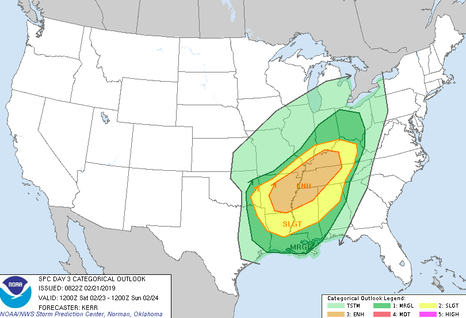
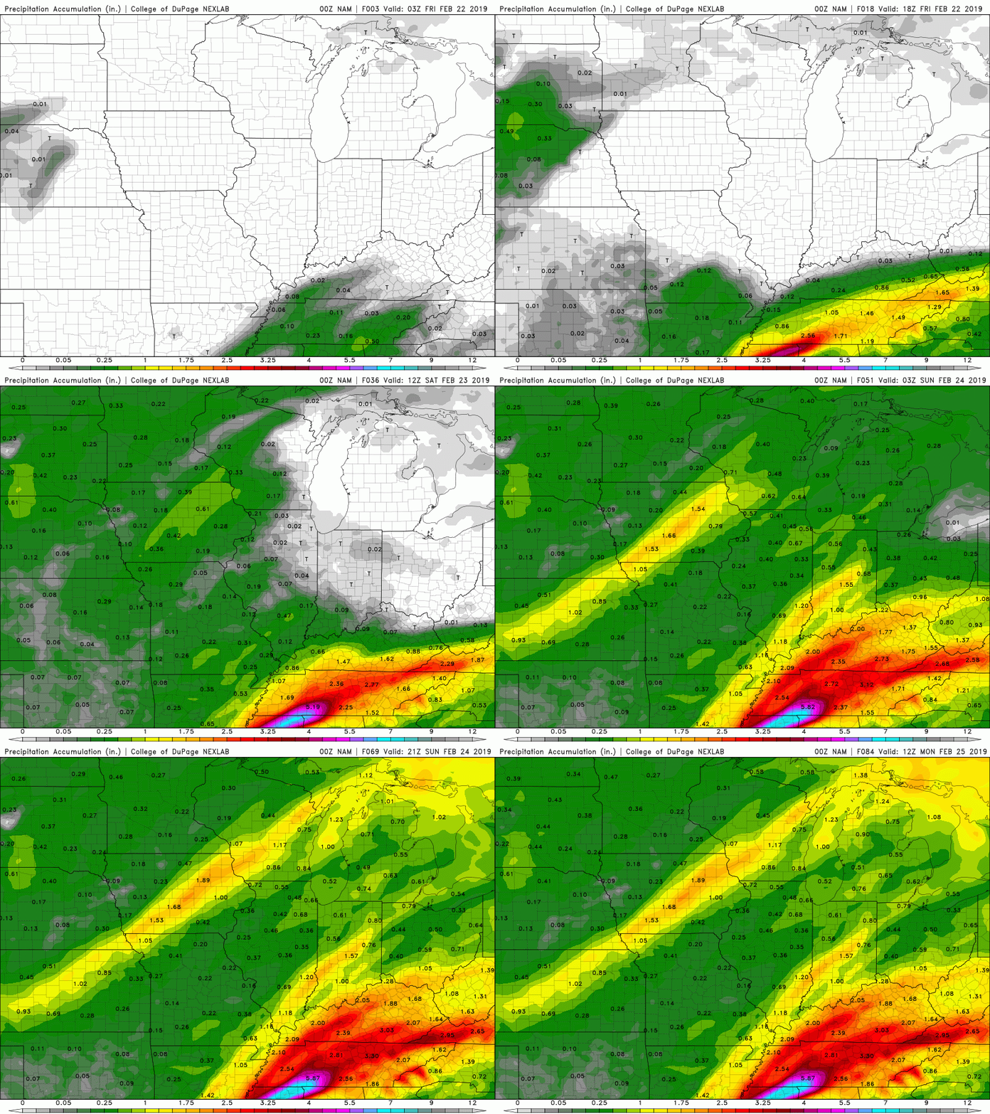
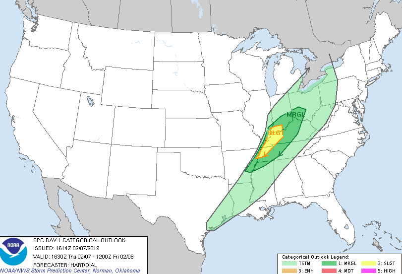
Good evening! To start, don't forget those umbrellas and rain jackets out the door in the morning. I'm sure if you forget, the rain on your way out the door will remind you anyway. As for the outlook Friday and for the weekend, its another wet, gloomy few days. It is important to note we are under a FLOOD WATCH until February 23 at 7am. On the bright side, next week looks to be mostly clear and SUNNY with high's in the 50's. So before we get to next week, lets discuss what will be happening over the next few days and namely, the next 24-36 hours. This graphic was produced today by the NWS (National Weather Service) with regard to the up and coming system moving in Saturday (Day 3 Outlook). For east TN, we are mainly under a Marginal risk with the far western portions of east TN bordering the slight risk. Basically, this means heavy rains as well as thunderstorms are expected with this system. The risk of tornadoes and hail is possible but not likely. The set up for this system is quit challenging due to its timing and location. Luckily, the bulk of severe weather will stay to southwestern TN, northern Mississippi, and eastern Arkansas. Lots of moisture from the gulf will funnel in combined with the convergence (or coming together) of the sub-tropical jet and a southern "chunk" of the polar jet. This will cause lots of vorticity (spinning), energy, and moisture (from the Gulf) to supply the system. For the areas described above, (north Mississippi, eastern Arkansas, and southwestern TN) tornadoes, heavy winds, and lots of rain is on the medium end of likeliness. As I said though, this system will phase out (weaken) by the time it reaches the east TN area. Be advised this system will still contain the possibility of heavy rains, winds, and thunder (at times). To clear any confusion, the more severe threat (heavier rains, thunder, and winds) is expected to occur Saturday afternoon/evening. As for Friday, expect heavier rains at times embedded with thunderstorms, along with heavier winds at times. As seen above, heavy rains from late tonight/early Friday morning until late Saturday will bring total rainfall of 2-2.5 inches. Portions of the far western parts of east TN could receive more. Once this system moves out late Saturday night, expect the sun to return and temperatures to be comfortable with high's in the 50's most of next week. For your daily forecasts, check out the "Weekly Forecast" tab at the top right portion of our page. Stay dry and be safe as flooding is possible over the next few days.
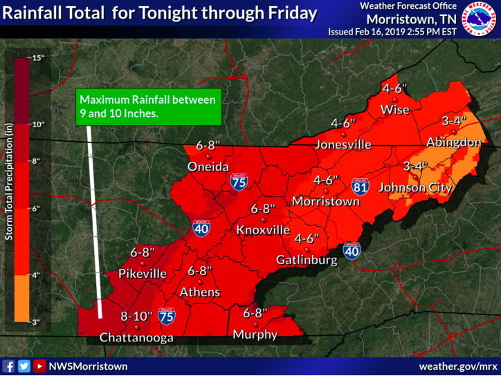
Forget the cars and break out the boats, as that may be your only way of getting to work this week. This may be a slight exaggeration, but it will be a very wet week. A series of low pressure systems will be working their way through our region this week bringing lots of moisture with it. It is important to note the potential hazards these systems will bring. Below you can see the rainfall potential from Sunday until Friday. The hazards associated this week are the potential for flooding and/or flash flooding. TVA worked today releasing water in preparation for this weeks rain so that the dams were less likely to overflow. I expect flood warnings and watches of some kind to be released by the National Weather Service (NWS) sometime this week. As always I will keep you updated of these as they come about. As for this week, it will be a spring like feel with temperatures mainly in the 50's during the day and 40's at night. Today showers will begin in the morning and be scattered throughout the day. Into tonight, showers will become more constant. Expect a high today in the mid 50's with a low near 40 overnight. President's Day (Monday) will be the best day for any outdoor activities or errands that need to be done. High's are expected to be in the low to mid 50's with partly cloudy skies. Moving into Monday night, clouds will increase and leave a low around freezing (32 degrees). Tuesday will be mostly cloudy for the first half of the day with showers moving in early afternoon. This rain will funnel in from the Gulf and stick around until the weekend. Below is the GFS (Global Forecast System) model run from Monday evening until Sunday evening when the rain is expected to finally move out. Stay save and dry this week as there is likely to be flooded areas throughout east TN. I know the phrase may be old or over used, but "Turn Around and Don't Drown". As always I will keep you updated here and on our Twitter with the latest changes, expectations, and alerts that may come this week! Also don't forget to check out the "Weekly Forecast" tab with what you can expect daily. Sources: NWS and Tropical Tidbits
Grab those umbrellas and rain jackets as it will be a wet one for the early portion of this week. The northern half of east Tennessee is under a Flood Watch. The Flood Watch is in effect until Tuesday (1/12) at 7 pm. A low pressure system to our west is bringing a large amount of precipitation being fed from the southeastern Pacific. As the low progresses to the east this evening, it will bring the potential of some heavier periods of rain. Rain tomorrow morning and into the afternoon is likely to bring another 1"+ to most of east TN. According to the USA Climate Data, Knoxville and the surrounding cities typically receive around 4″ of precipitation for the month of February. This means, Tuesday alone could bring 1/4 of the monthly average amounts. Due to the active pattern of the subtropical jet and polar jet, we have received above average amounts of rainfall for the month of February. As you can see below, heavier rain is expected to arrive late tonight and continue into the first half of Tuesday. 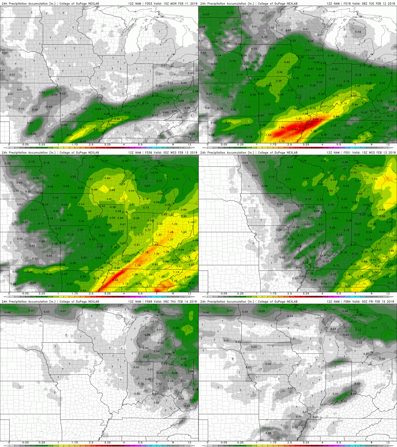 24-Hour Precipitation Amounts (Source: COD Weather) Hold on for a couple more days and the rain will move out bringing back those sunny skies. Wednesday and Thursday is expected to be mostly sunny with high's in the low 50's and low 60's, respectively. For more detail on the high's, low's, and rain chances, refer to the "Weekly Forecast" tab located at the top right portion of the page.
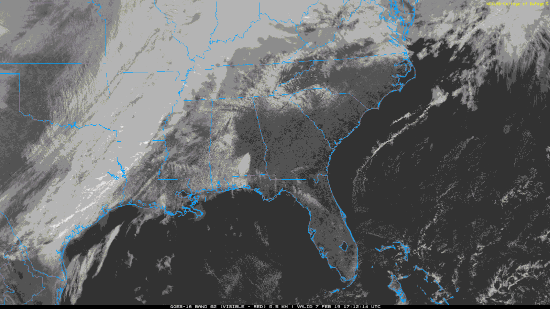
Most of east Tennessee is under a WIND ADVISORY until 8pm tonight. This means strong winds are likely throughout the day with gusts upwards of 40mph possible. For right now, satellite shows it being mostly cloudy outside right now. This will continue throughout the day before a line of showers impacts our area tonight. This line is likely to be pretty strong bringing heavy showers and some thunder/lightning. Overall, it is beginning to weaken so when it reaches our area any real threats are likely diminished. With this being said, the National Weather Service (NWS) Storm Prediction Center (SPC) did release this graphic. This shows a large portion of east TN is expected to receive some stronger rain embedded with thunderstorms. To the west the threat is more severe, but as I said, the system is or has peaked out so it will be weakened by the time it reaches our area. Following this line of showers will be a cold front. This cold front shouldn't bring any snow or freezing precipitation with it, but those cold temps will return making it feel more like the winter season that it is. Temperatures tonight should dip down into the mid 30's. For Friday, it will be chilly with highs in the upper 30's and decreasing clouds throughout the day. Saturday looks to be the nicest day with highs in the mid 40's and partly cloudy skies. Sunday and early next week, we will receive our next round of rain. Sources: COD Weather, NWS
I thought this would be an interesting read not only to those fascinated by weather but also to history buffs. On February 5th every year, weatherperson's day is celebrated. Why this day? Well this is the birthday of John Jeffries. John Jeffries was a physician and one of America's first recorded weather observers. His weather observations were first recorded in 1774 in the city of Boston. He was known to always carry a thermometer (temperature), barometer (pressure), and hygrometer (humidity) wherever he went. In 1778, John conducted the first ever weather balloon observation. Since then, February 5th has been declared the day meteorologists, weather forecasters, broadcast meteorologists, and volunteer storm spotters/observers are recognized! For a more in-depth information on John, his life, and the things he has done, visit: http://www.celebrateboston.com/biography/john-jeffries.htm
(Sources: National Weather Service and Celebrate Boston) How about this beautiful weekend of warm temperatures and plenty of sunshine! The trend will continue this week with most of the high's in the 60's and a chance at 70. For your Monday, it will be a partly cloudy to a cloudy day with a chance of rain. Monday and Tuesday looks to have scattered showers throughout the day. These will be relatively light and dispersed showers. Besides the chance of showers, it will be partly cloudy for each day. High's to be in the low 60's Monday and mid to upper 60's Tuesday and Wednesday. Longer and likely, heavier rains, will arrive Wednesday. Wednesday, Thursday, and Friday look to be the wettest days this week. Break out your umbrellas as this week looks to be a pretty wet one, especially in the mid to late part of the work week. After the rain moves out Friday, cooler temperatures are to follow bringing back temperatures in the 40's as the high. I will post sometime mid week to let you know the rain amounts, timing of the rain, and when you can see this system move out. Enjoy your Superbowl Sunday!
Happy Groundhog Day! I hope everyone is enjoying their Saturday with much warmer temperatures and mostly sunny skies. I thought I would share a little meteorology/ weather history prediction fun. Today, Punxsutawney Phil, the famous weather prediction groundhog made his annual debut. So what were his predictions for the rest of the season...? Well, he did not see his shadow today meaning Spring is expected to begin early. Though Phil predicts a soon start to the Spring season, his annual predictions do not have a positive track record with only "getting 40% of his predictions correct" (NOAA). So where does this tradition begin? Starting sometime in the 1700's Christian settlers brought a tradition known as Candlemas Day. This day was to be the mid-point between the Winter Solecistic and the Spring Equinox (February 2nd). On this day, candles were distributed for the typical dark cold days. According to legend, if it is a mild day (filled with lots of sun), it will be a cold wet end to the Winter season. Oppositely, a more mild and warmer end of Winter was set to begin (the onset of Spring). Regardless of Phil's predictions today, it is much warmer today, at least for east TN, with temperatures in the 60's this weekend. I hope everyone enjoys their weekend of warmer temperatures and mostly sunny skies before the rain returns next week! Picture Source: Weather.com
|
Your trusted source for everything weather in East Tennessee.
Social Media
|

