|
Heres the live shot from I-40 at 17th street in Knoxville. As you can see in the background, blue skies have made a return today and will continue for the start of the weekend as well. As high pressure builds in, clear skies and warming temperatures will continue for Saturday and parts of Sunday.  Looking at the temperature change from the past 24 hours, we are trending 5 to 10 degrees cooler. A cold front resides just to our east and runs up and through New England. To the west, high pressure will meander southeastward bringing warmer air for Saturday. Highs today will top out in the low to mid 70s with highs Saturday in the mid to upper 70s. 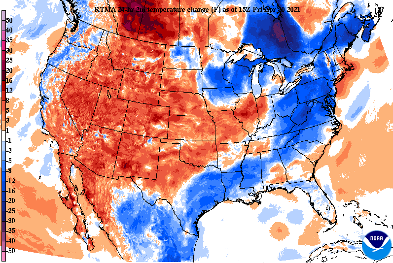 By the end of the weekend, cloud cover will once again arrive. Our next round of showers and storms will be in by Sunday night and continue throughout parts of Monday and Tuesday. A low along the panhandle of Texas will shift north bringing rainfall amounts close to an inch for the area. There is still quite a bit of uncertainty on the exact path, so rainfall amounts will vary until we get closer to time. For now, expect a wet start to the new work week with temperatures in the upper 70s and low 80s.  The first half of the weekend will be beautiful with lots of sunshine and temperatures around the norm. Don't forget to share your adventures and views with us by submitting pictures to [email protected] or by tagging us on Twitter/Facebook. Pre-recorded for 5pm show
1 Comment
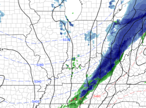
Good afternoon! We have stayed dry through the morning hours but showers sit just to the west. The initial line is just across the plateau and beginning to work into the valley now. Moderate showers and and gusty winds are possible through the evening tonight before gradually clearing takes place into Friday. Highs today to be around 80 degrees.  Severe weather is generally off of the table today. We are under a Marginal Risk for severe weather but the potential is isolated at best. If storms this afternoon do organize enough, gusty winds, hail, and lightning/thunder are the primary threats. As seen below, showers should be out by early Friday morning and cooler and drier air will follow. We'll see sunshine Friday afternoon with highs in the low to mid 70s. Similar conditions are in the forecast for Saturday (Derby Day) with highs nearing 80 and lots of sunshine overhead. Another system (current along the Gulf) will move north bringing our next round of showers late weekend and early next week.  We will cool down a bit working into Friday but in reality this will be closer to the average for this time of the year (mid 70s). Saturday will be the best day of the weekend as showers arrive the later half of Sunday and into early next week. Pre-recorded for 5pm show
As a low pushes out of the Central Plains, cloud cover will continue increasing this afternoon and night. This will lead to showers the latter half of Thursday and cooler air for your Friday. For today, another warm one with highs in the lower 80s. 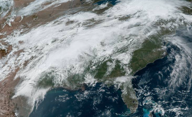 Thursday will be our last "seasonably warm" day for a bit, as a cold front shifts through Friday. Looking at highs tomorrow, East Tennessee will range from the low to mid 80s. Just to the west, where shower coverage will be the best early, temperatures are much cooler in the low to mid 70s. By Friday, a cold front will have moved through leaving highs in the low 70s. 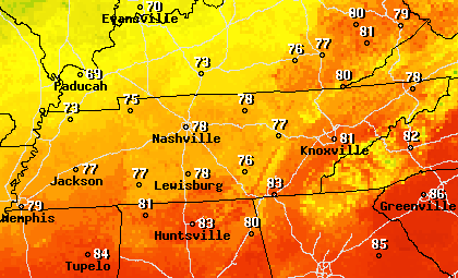 Future radar does hint at some light isolated showers for the morning commute tomorrow but the majority of activity will reside to our north in Kentucky. As the low and associated cold front work east, showers and an isolated storm or two is possible in the evening and overnight hours. The majority of rain will be out by Friday morning, but a few lingering showers along the Smokies will be possible. Clearing will follow for Friday afternoon with sunshine returning Saturday and parts of Sunday.  That will do it for today, much of the prime daytime hours tomorrow will be cloudy before showers arrive towards the evening. Have a good one and stay cool (temps remains above average one more day). Pre-recorded for 5pm show
A warm afternoon is underway with temperatures 8 to 12 degrees above what they were this time yesterday. High pressure off the coast of the Carolinas will continue to pull in warm and humid air for Wednesday, as cloud cover increases through this afternoon and into Wednesday. The norm for this time of the year is 73 degrees and highs are expected to top out in the low to mid 80s this afternoon. 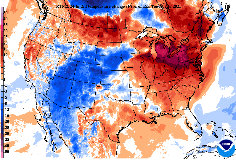 The forecast remains pretty well on track. Increasing cloud cover tonight and throughout Wednesday will lead to showers Thursday. Timing for the bulk of rainfall remains the latter half of Thursday and early into Friday. A few isolated showers will be possible Thursday morning, but nothing of concern or widespread. Following the rainfall, a cold front will knock highs Friday afternoon back into the upper 60s with sunshine returning for Saturday and highs near the norm.  Remain hydrated! With temperatures above normal and humidity on the rise, that could lead to some minor heat related issued. Highs will again return to the mid 80s Wednesday before showers and cold front cool things off later in the week. Pre-recorded for 5pm show
Good afternoon! A beautiful day is in production with lots of sunshine and warm temperatures to accompany. We are seeing temps across the valley in the mid 60s and will warm to highs nearing 80 degrees. A look from GOES-EAST satellite depicts a nice view of the eastern half of the US with light cirrus working in from the west. 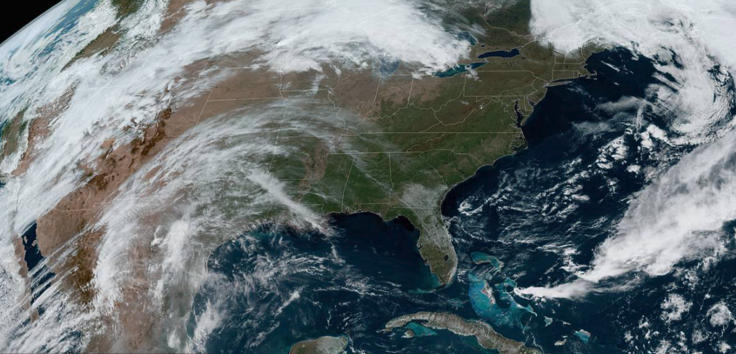 Jumping into Tuesday, an area of high pressure sits just off the coast of the Carolinas, pumping in very warm, summer-like, air. We'll see highs tomorrow nearing the 90 degree mark for some. Across the Valley, highs are expected to top out in the mid 80s. Looking at how this compares with the norm, we'll be 10+ degrees above average Tuesday and Wednesday. 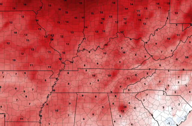 Aside from the warm air we see Tuesday and Wednesday, another system will round out our week. Cloud cover will be on the increase the second half of Wednesday (potentially tampering with highs slightly). By Thursday, showers will beginning working in from the west. Timing looks to be the second half of the day but a few isolated showers can't be ruled out early. By the evening, widespread showers and a chance for lightning and thunder are possible. As a cold front works through Friday, cloud cover will begin clearing out just in time for the weekend. The biggest trend early this week is the heat. Highs average the mid 70s this time the year and some locations could near 90 tomorrow afternoon. Protect yourself from the heat and remember to drink lots of water if you are outdoors for extended periods of time. Showers and a cold front will cool things off by Friday before drier weather prevails into the weekend. Pre-recorded for 5pm show
We'll start it off with good news! The latest drought index across the state remains consistent to last weeks outlook at normal conditions. I anticipate this to continue as another soaking rain arrives tomorrow and again mid to late next week. The CPC also suggests above average precipitation to close out April and enter early May. As for the day today, clear skies start but cloud cover migrates in as a system to our south works north and east across the Mississippi and Ohio Valleys. Highs today will continue to increase from yesterday, topping out in the mid 60s. 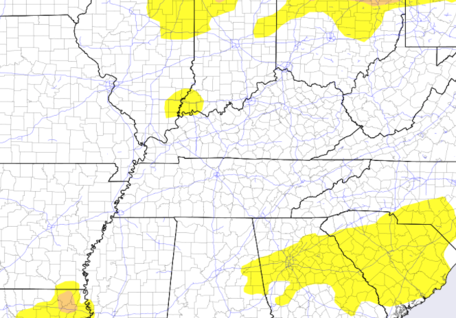 With a low developing in Texas late yesterday, it will progress north and east today. This will increase the cloud cover this afternoon and lead to showers late tonight and into much of Saturday. For the most part, this will be a moderate soaking but heavy showers and a few isolated thunderstorms are possible (specifically the second half of the day). By Sunday, clearer skies work back in as high pressure approaches from the upper Midwest. This will keep things sunny and warming by early next week with highs in the low to mid 80s Tuesday and Wednesday.  Looking at QPF (quantitative precipitation forecast AKA estimated forecast rainfall totals), the bulk of heavy rainfall has dipped a bit further south than yesterday's forecast, but still leaves upwards of an inch and a half for south East Tennessee. Across the Valley, upwards of an inch are likely before drying back out Sunday afternoon.  That will do it for the week...I hope everyone has a wonderful weekend! Showers will fulfill much of Saturday, making Sunday the best day of the weekend. We will also see more normal temperatures Sunday afternoon with above average highs early to mid next week. Last note: we did break the low record for Chattanooga (previously 33) and Knoxville (previously 31) for yesterday morning. Pre-recorded for 5pm show
It's a bone chilling morning (for this time of the year) as current temperatures across the valley sit in the upper 20s and low 30s. To put in perspective how abnormal this air mass is, the average low for mid to late April is near 50 degrees. The record low for the 21st (in Knoxville) is 27 degrees and is 31 degrees for today (the 22nd). We'll see what was officially recorded later today, but I bet we come close to the record. For tonight, we'll be a bit warmer, so not expecting a record beating night. With that said, frost conditions are likely, especially for sheltered locations.  Courtesy of the Stansfield's Looking ahead, another system looks to bring heavy rain across the Volunteer state. High pressure will be edged out by a strong low to our south, bringing moderate to heavy rain at times Saturday. A warm front will lift northward bringing warm temperatures (along with trailing high pressure) to follow late in the weekend and early next week. Highs are expected to average above average; quite the difference from what we feel now.  Looking at rainfall totals, some locations could see upwards of 2 inches from Friday night through Saturday evening. Flash flooding isn't a huge concern, given how dry we have been the past several days, but localized flooding can't be ruled out entirely. Expect rainfall to work out by Saturday evening with clearing in for Sunday and sunshine for early next week. 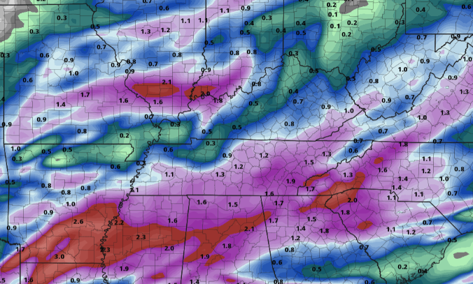 Another chilly night tonight with lows in the mid to upper 30s. I expect frost advisories to go out with the afternoon package today from the NWS, so be on the look out for that. Protect those plants one more night, and we should be in the clear. Temperatures next week will average on the warm side with highs some days in the low to mid 80s. Pre-recorded for 5pm show
I hope you are bracing for a chilly day. As you can clearly make out below, the cold front has pushed through providing a temperature change of nearly 20 degrees from this time yesterday. As the day progresses, we won't warm up too much as highs top out around 50 degrees. We do gradually warm through the day, but this afternoon (especially) and Thursday will be on the chilly side. 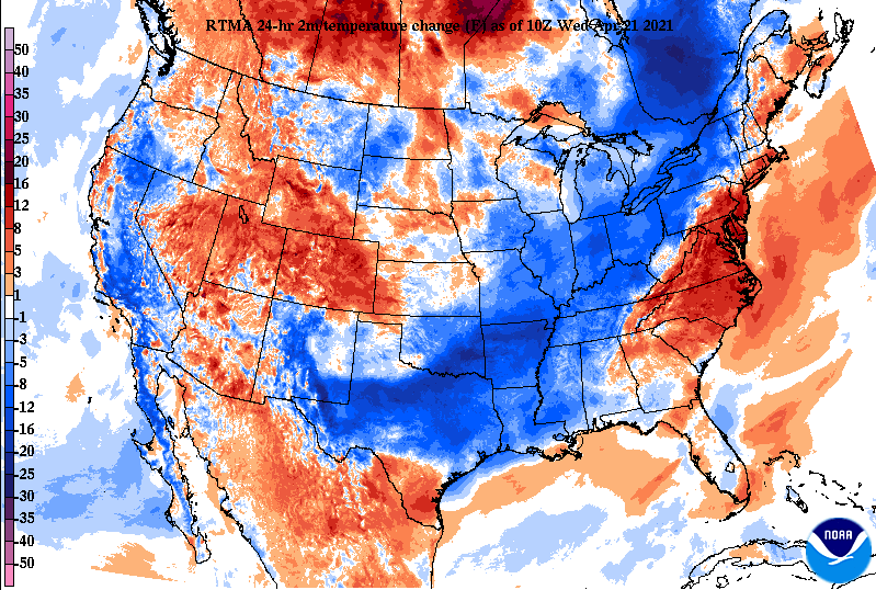 In addition to the cold temperatures, a brisk north/northwest wind will make temperatures feel even colder. Gusts will be up to 25 mph during the afternoon. High pressure intrudes the eastward half of the US, allowing for clearing through Thursday and most of Friday. Again though, another system is expected to bring widespread shower activity Saturday before clearing once again returns late in the weekend and early next week. 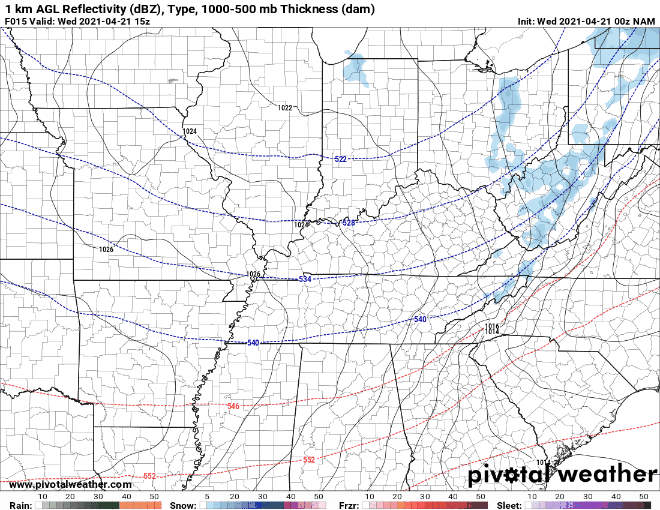 Long term, the CPC suggests another pattern shift; this time, a warm one. Closing out the month of April, temperatures should be on the warm (above average) side. The CPC also suggests precipitation to be above average to close out the month.  A FREEZE WARNING is in effect overnight tonight. Protect sensitive vegetation both tonight and tomorrow night as frost and freezing temperatures are likely. Overnight lows for most will be in the upper 20s to low 30s, with some sheltered locations dropping evening cooler. Check out more information below. Pre-recorded for 5pm show
Good Tuesday morning! A few clouds hang high in the skies above the Smokies, otherwise the remainder of East Tennessee is mostly sunny to begin the day. After what seems like many weeks, temperatures will make a return to average with highs topping out this afternoon in the low to mid 70s. Unfortunately, a big change comes Wednesday. 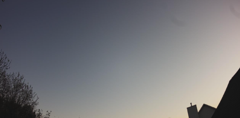 Image courtesy of the Stansfield's The biggest highlight ahead comes this time tomorrow. A strong cold front is set to arrive tomorrow morning bringing the chance for a few light showers and even a few flakes (yes I said flakes in mid to late April. Though winter precipitation isn't normal this time of the year, the temperatures to follow won't be either. Highs Wednesday afternoon are set to be in the upper 40's to low 50's for most with gusty winds at times (will make things feel even colder). In addition, overnight lows Wednesday into Thursday will be in the upper 20's to lower 30's, so frost advisories and freeze warnings are more than likely. Following the cold swing, temperatures will slowly rebound into the weekend before another system brings better rain chances Saturday (no cold with this one). 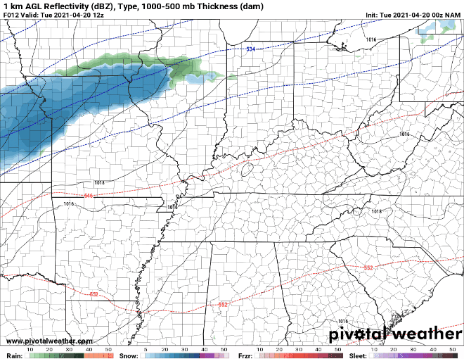 Looking from the left first, this is a shot of high resolution short-term guidance suggesting that four letter word (snow) across parts of the Plateau and Eastern Kentucky. Though little to no accumulations are expected, some will likely see a few flakes to mixed precipitation early Wednesday morning. We'll clear out by the afternoon but stay chilly. The image to the right (hard to see) depicts lows in the mid 30's across valley locations. Model guidance does a poor job with temperatures, so will clear skies and an abnormally cold air mass rolling through, I am fully expecting lows in the upper 20's and low 30's Wednesday night.
That will wrap it up for today! Enjoy the beautiful conditions and "warm" (but actually average) highs expected this afternoon. We'll continue to update you on the latest advisories and warnings (potentially) issued in the days ahead. Take the proper precautions now though to protect sensitive plants and vegetations as cold air is set to arrive early Wednesday morning. Pre-recorded for 5pm show
Noon-time temperatures stand in the upper 50s but will warm to highs around 70 degrees. Looking below, high pressure sits across Smokies but will continue to shift east for Tuesday. This will allow temperatures to warm back up with highs tomorrow expected to be in the mid 70s. Unfortunately, this won't last long, as a cold front quickly trails for midweek.  As cold air funnels across the Upper Midwest today, its eastward trajectory will eventually cross the Tennessee Valley, bringing well below average temperatures. Looking at Wednesday morning, you can clearly make out where the front is located. The temperature gradient varies nearly 30 degrees from west to east. This will make things challenging for the Ag world, as frost and freezing temperatures are likely. Some locations, namely the Plateau, could even see a flurry or two Wednesday. Prepare now for protecting crops and sensitive vegetation both Wednesday night and Thursday night. 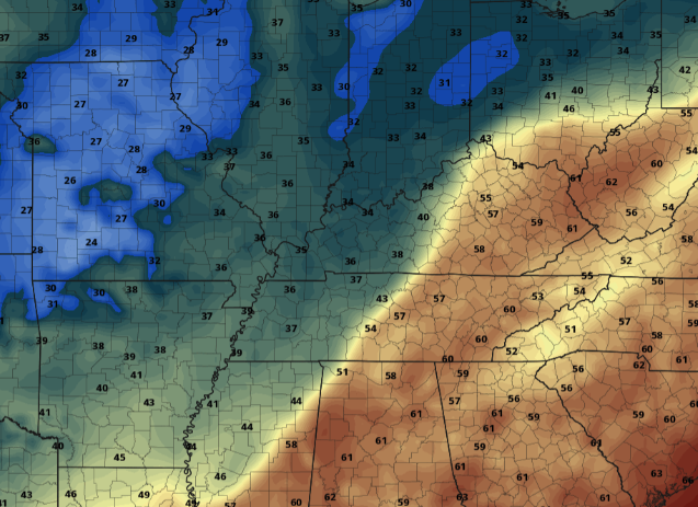 There isn't a ton to highlight precipitation-wise ahead. As the cold front works through Wednesday, there will be isolated showers/sprinkles possible. Some of the higher elevations could even see a flurry or two before the precipitation departs north and east. Following, sunshine is set to return with temperatures gradually warming towards the end of the work week. 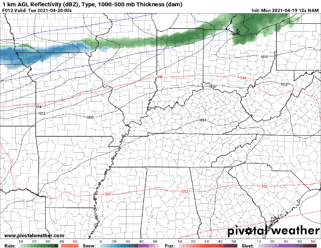 The biggest highlight ahead remains to be the shift in cold air midweek. This will be a critical timeframe for the Ag sector as growing season is well underway. Cover and insulate tender plants and also think about livestock/pets who may be outdoors a bit more than in the winter. Pre-recorded for 5pm show
|