|
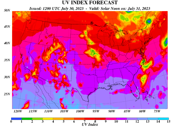
I hope you are having a good Monday thus far! I am sorry for the lack of posts this past week, as I was off enjoying the sunshine in Florida. That said, I hope you followed along on social media (Twitter & Facebook) as it was a rather active week at times. Moving forward, another unsettled pattern unfolds towards the weekend, while plenty of sunshine finds us through tomorrow. Looking at the UV Index below, we are in the "very high" category. Be sure to have the sunscreen ready if planning to be out and about for an extended period of time today and tomorrow. Cloud cover and shower chances begin moving back in Wednesday through Friday. Speaking of those shower/storm chances, how much rainfall are we talking. As of now, 0.75-1.75" is a fair guess, but that will depend on thunderstorms and where activity tracks. Those that experience stronger and/or repeated activity will favor higher amounts, while those elsewhere can expect near an inch. Overall, Wednesday night through Friday should expect a soaking rain, with cooler temperatures as well. Instances of isolated flash flooding can't be ruled out, but the dry conditions we have had yesterday, today, and for most tomorrow, should limit that potential. Looking at the break down of model guidance, most stay dry through tomorrow, though an isolated shower can't be entirely ruled out in the afternoon. Into Wednesday, shower chances will slowly increase through the day, with the best chances holding off until Thursday. Lingering activity will hold on into Friday, followed by our usual summertime shower or storm chances (in the afternoon) through the weekend. Temperatures will also warm back up to the 90 mark Saturday and Sunday. As far as the shower and storm chances (best Thursday), a few strong storms containing gusty winds or hail are possible. The severe threat, as of now, is low but not something to rule out as usual during the warm season. Other than the sunshine, temperatures should be near average today and Tuesday. Take advantage of the pleasant conditions, before unsettled weather returns Wednesday and through the end of the week. Don't forget to check out our video forecast below as well. Pre-recorded for 5pm weather broadcast
0 Comments
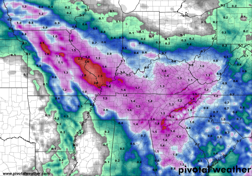
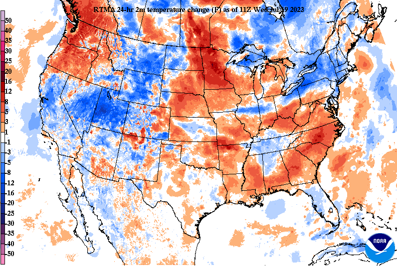
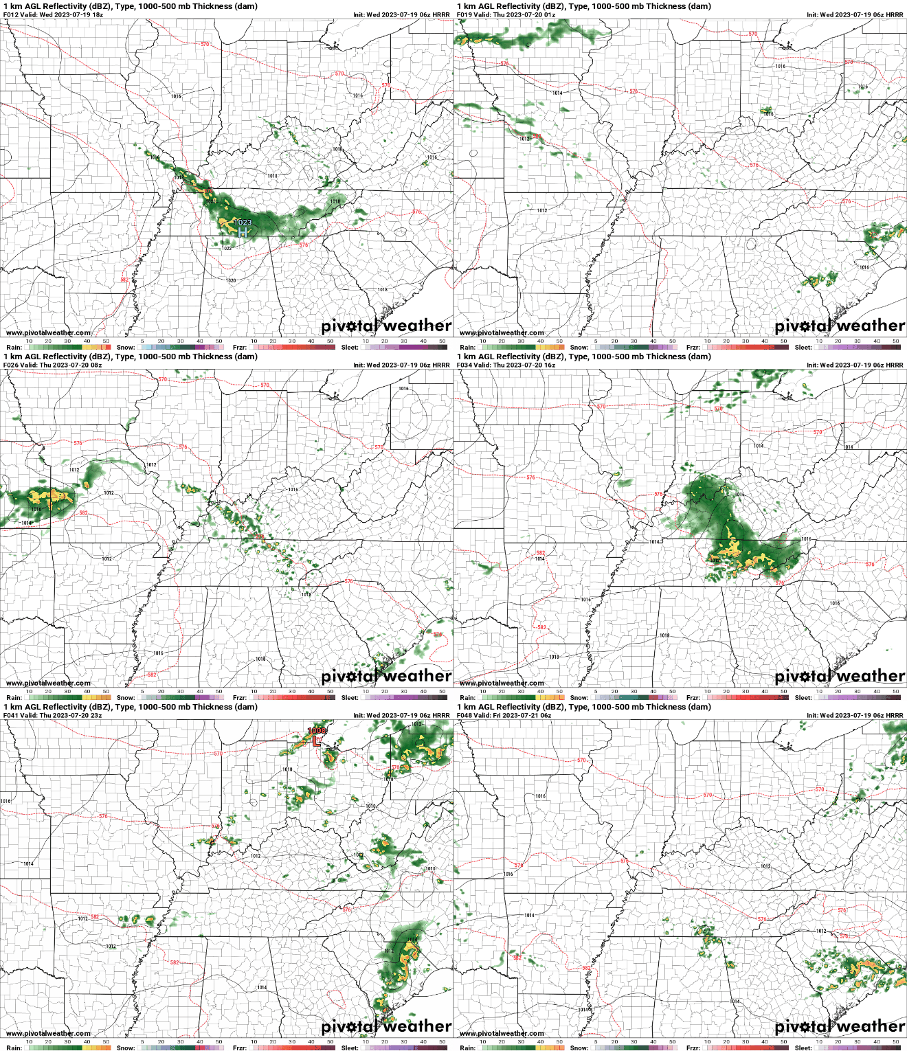
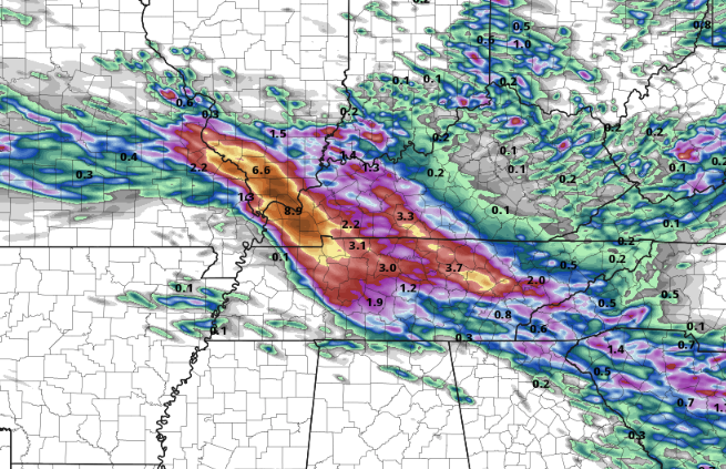
A pocket of cooler air across Tennessee and into Kentucky this morning, can you guess why? Rainfall! A complex of showers and thunderstorms is working out of Illinois, Missouri, and Kentucky and is sinking southeast with time. This will continue at times through the day, eventually coming to a close (for a time) this evening into tonight. So checking out this incoming "pain train," you can see the path this activity is taking- working across West and Middle Tennessee and progressing south into Georgia and the Carolinas. The biggest concern overall will be the flash flooding/flooding risk. With soaking rains seen from the past couple of days already, another few inches in spots will only increase those odds. Additionally, a few strong storms will be possible into this afternoon, with strong to damaging wind gusts and isolated instances of hail. Unfortunately, another round of similar circumstances finds us through Thursday. Again, strong storms will be possible into Thursday afternoon but flash flooding will be the higher risk through the day. Please be weather aware today and especially Thursday and have several ways to receive warnings if they are issued. Looking at rainfall amounts, pockets of 3-5"+ will be possible (with locally higher amounts not ruled out) through tomorrow. Concerns will be across the Plateau with terrain enhancement, along with any strong and repeated (training) storm activity. In general, 2-4" appears likely, with the least amounts in the southern plateau and far northeast Tennessee. Take precautions now to prepare for potential flooding and/or strong storms. Isolated to scattered instances of both are possible today and Thursday, before much needed drier air returns in time for the weekend. Saturday and Sunday will also be cooler, with highs in the low to mid 80s.
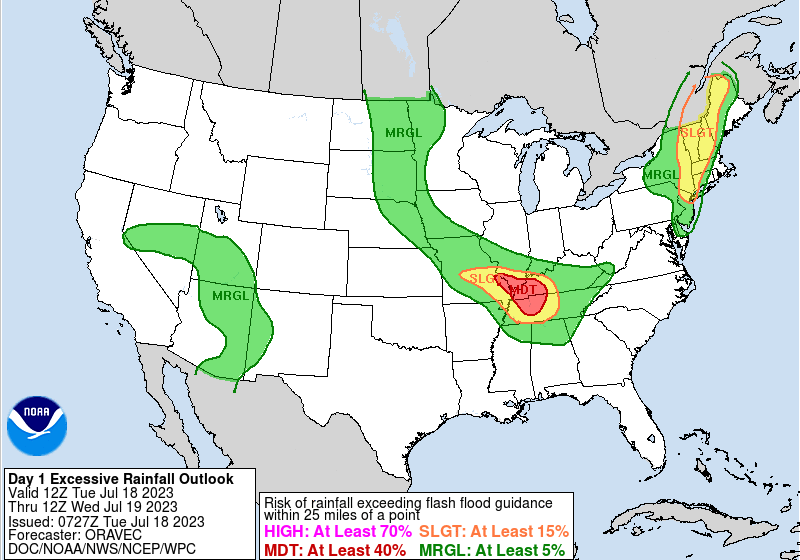
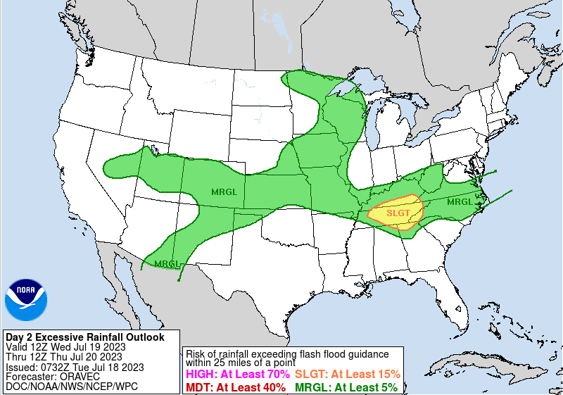
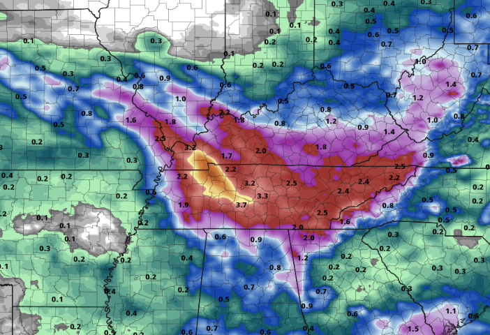
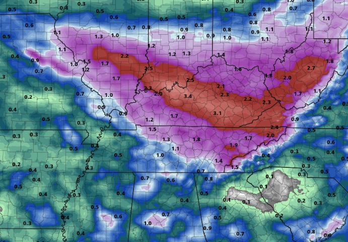
The weather concerns moving forward remain relatively the same. Flash flooding risks will grow through the week, and even a few strong or severe storms will be possible during this time. Looking below, the flash flood risk is Moderate (at least a 40% chance of occurrence) for portions of West TN and KY today. The complex that will affect this portion of the state will eventually move into our neck of the woods tonight. Keep in mind there is still quite a bit of uncertainty in the true path of this swath of storms, as some guidance has it staying further west, while others right across East Tennessee. Given this, prepare now for the chance of having heavy downpours, rising water basins, and flash flooding. Into Wednesday, the risk grows to a slight risk across us, where a continued flash flooding risk remains through the day Friday when the boundary FINALLY pushes south of the state. Looking at the suggested mean rainfall amounts through Friday, things have gone up since yesterday. We are now looking at amounts between 2 and 4 inches, with locally higher amounts certainly possible. Again, given the uncertainty in how this thunderstorm activity pans out each day we could see an uptick in amounts or just the opposite. In terms of timing of waves of showers or storms, isolated activity is on going this morning. We will see an increase in coverage this afternoon, where the mentioned complex could impact the area this evening and through the night. Another round of showers and storms then finds us Wednesday followed again by activity Wednesday night into Thursday. Lastly, the frontal boundary to the north will break south where one last shot at rainfall arrives Thursday into Friday. Drier air then returns into Saturday and Sunday, with temperatures also cooler through the weekend. Be weather aware over the next several days. A series of passing disturbances will progress through the area, bringing a flash flooding and isolated severe risk. Heavy rainfall, frequent lightning, gusty winds, and some hail will be possible at times today through the rest of the work week.
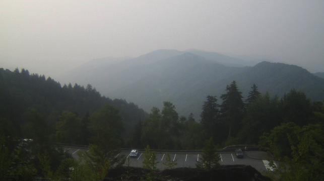
Good morning all! We are starting out on a foggy/hazy note, with this view over the Smokies at the Newfound Gap area. The good news today, hazy conditions will be on the slow decrease through the day, with clearer air in the works through the week. The bad news? Several passing disturbances will bring a flash flooding threat with a few strong storms also possible today through Friday. In terms of temperatures, we will top out in the mid and upper 80s this afternoon, which will be the theme throughout the week. Muggy conditions will only get worse towards Wednesday. So what about this flooding threat? Well, it is complicated. A strong area of high pressure is settled across the Southwest United States, which will allow for a series of disturbances to ride on the edge of the high and bring rounds of rainfall to the Tennessee and Ohio Valleys this week. A cold front is also dropping south, stalling out across Kentucky into midweek. As it does so, warm and moisture rich air will be pumped in from the Gulf. With clusters of storms more defined on small scale details, models are having trouble pinpointing exact timing, strength, and duration of precipitation (at least beyond Tuesday night). As such, giving exact rainfall amounts will be a challenge. Nonetheless, here is a best guess as of this morning, with 1-3" possible across East Tennessee. Keep in mind, if storm tracks change, are slower, strong storms occur, or locations see repeated activity, amounts can largely change (for better or worse). Keep your safety in mind through the week, as flash flooding potential will grow by the day. Here is a *general* depiction of how things could play out. A cluster of storms is moving through Kentucky now, which could bring some showers or storms to some along the border (north). Redevelopment will occur this afternoon, bringing a scattered shower/storm chances for those primarily along and north of Interstate 40 into tonight. Activity will begin to dwindle late in the night, with additional development mainly tomorrow evening and into the night. This second round (tomorrow) night will pose the best risk of the two day span for heavy rainfall rates. A few strong storms, posing gusty winds and some hail, will also be something to keep in mind too. A third round then follows Wednesday, before the cold front begins sliding through and a last round of showers/storms comes Thursday into Friday. The weekend generally looks a bit drier and cooler overall. With uncertainty in the finer scale storm details, be sure to check back in throughout the work week and follow along on our Twitter and Facebook. Forewarning, we will be off starting Thursday and through much of next week with website posts (here) but we will remain very active on social media. Pre-recorded for 5pm weather broadcast
Pre-recorded for 5pm weather broadcast
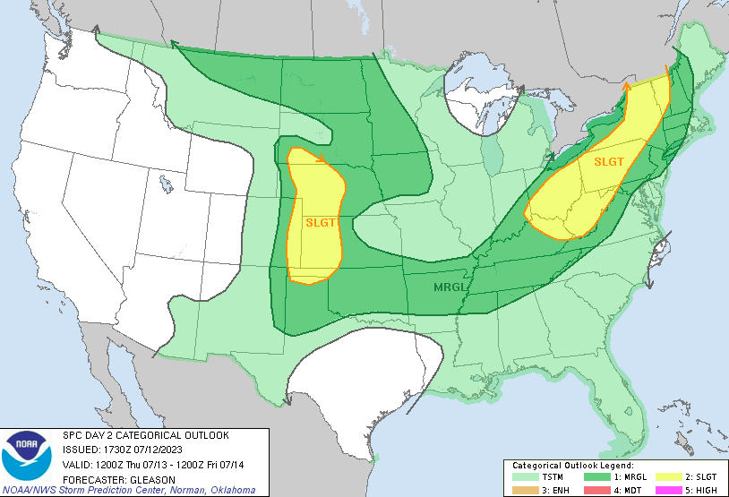
Good morning! I will start by highlighting the severe risk/threat we have today. An approaching and slow moving cold front will bring the opportunity for both strong storms and heavy rainfall. The timing for this activity will come later this afternoon through the early overnight hours, where damaging wind gusts are the primary threat, but isolated large hail is also possible. In addition to the marginal severe risk, a marginal flash flooding risk (not shown) is also present. Within slow moving and stronger storms, the chances will be highest. Any locations that see several rounds of rainfall will also be at a much higher risk. Be weather aware not only today but through the weekend as well. A simulated run of what could happen today, shows isolated activity beginning to pop up early to mid afternoon, with increasing chances this evening into early tonight. Though this isn't exactly what will occur, the idea remains the same. Shower and storm chances will increase with time, with activity starting as early as the lunch time hour. Renewed threats for showers and storms then follow Friday, Saturday, and Sunday with the best chances during the afternoon and evening hours. Saturday will again be a higher alert day, as strong to severe storms and flash flooding will be a possibility (higher threat than Friday and Sunday). Outside of the short-term period, a look further out suggests much of the same. Seasonably warm air and (not shown) near normal rainfall is expected as we swing into the second half of the month. Activity will more than likely be our summer classic: afternoon pop up showers and storms, but better chances will be at play with passing low pressure systems as well. That will wrap it up for today, be sure to check us out and follow along on Twitter and Facebook if you don't already. You can always stay up to date on our radar tab at the top of the page as well. Stay safe, stay cool, and have a good one!
Pre-recorded for 5pm weather broadcast
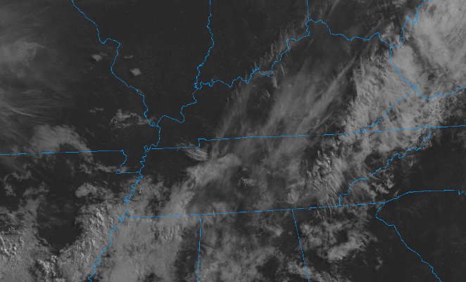
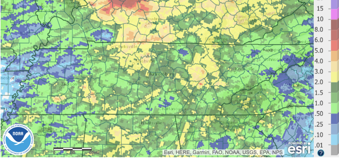
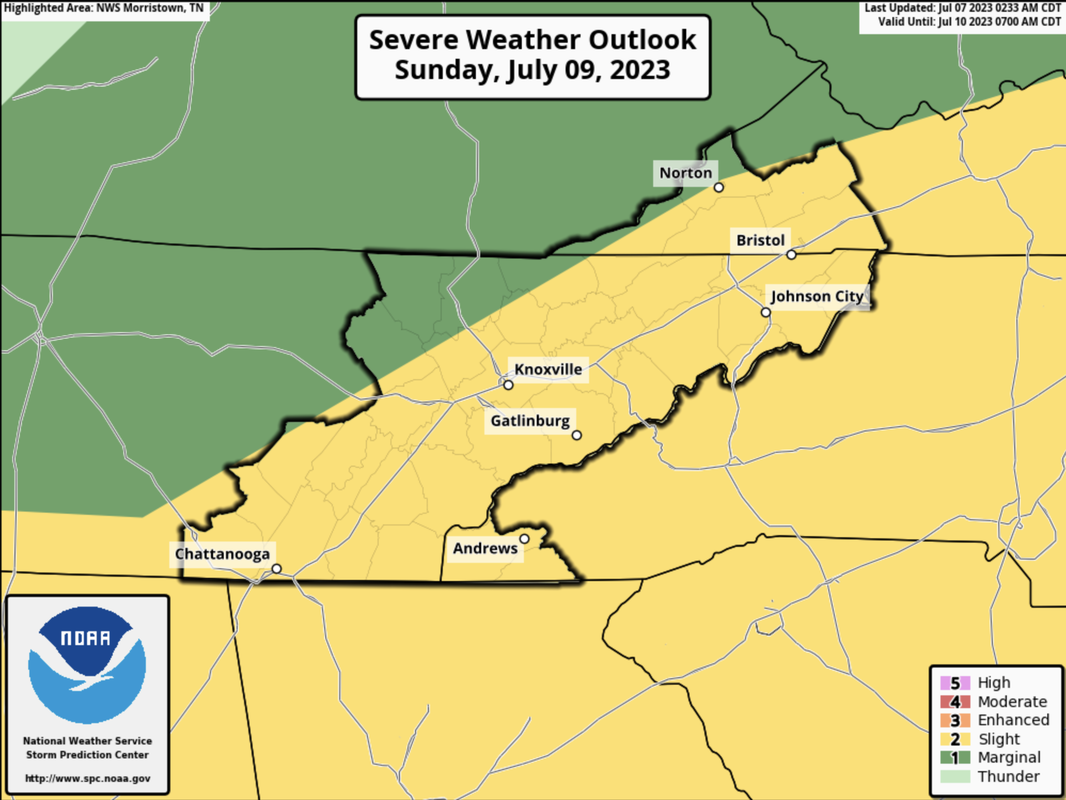
Good morning! Patchy dense fog started the day off, but has since started to burn off. Higher up, clouds are doing much of the same, as sunshine is creeping in more and more. By this afternoon, most will veer partly sunny with highs topping out in the upper 80s. Other than a few isolated showers in the far east (along the Smokies) most stay dry! Looking at our rainfall, unsettled weather has come in several waves as of recent. Looking over the past week (not including yesterday), most locations saw a healthy 1-3" with locally higher amounts in the central plateau and valley. As high as 5" was seen in these counties. Moving forward, another bout of heavy rain is in the forecast, before some much needed drier weather returns towards Tuesday. Speaking of that next round of rainfall, this is the severe outlook from the Storm Prediction Center. A slow moving cold front will bring the threat for scattered instances of damaging winds and the chance for large hail. The timing for this will come Sunday afternoon to evening, with activity weakening into the night. A few strong storms also can't be ruled out in the plateau late Saturday afternoon and evening. With the rainfall we have picked over the past several days highlighted above, the threat for flash flooding is a little higher. Be weather aware the later half of the weekend and have a way to receive warnings (both for severe and water related hazards). Temperatures will stay seasonal through Saturday, before cooling to the low 80s Sunday with rainfall, clouds, and a passing front. Highs will then moderate Monday into midweek. Enjoy the beautiful day we have ahead and stay safe through the weekend. We will be updating via social media, so if you don't already, give us a follow!
|
Your trusted source for everything weather in East Tennessee.
Social Media
|

