|
Staying mild with above average temperatures through at least early next week. Showers arrive tonight, continuing into tomorrow, before drying back out Saturday night and through New Year's Day. Another round of (or few rounds) of showers arrive Monday evening and through mid week, where cooler temperatures then arrive for your Thursday. View your latest forecast below: Pre-recorded for 5pm weather broadcast
0 Comments
Pre-recorded for 5pm weather broadcast
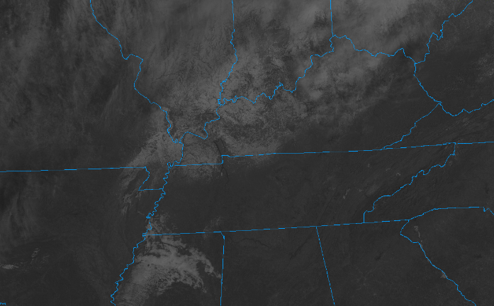
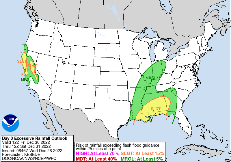
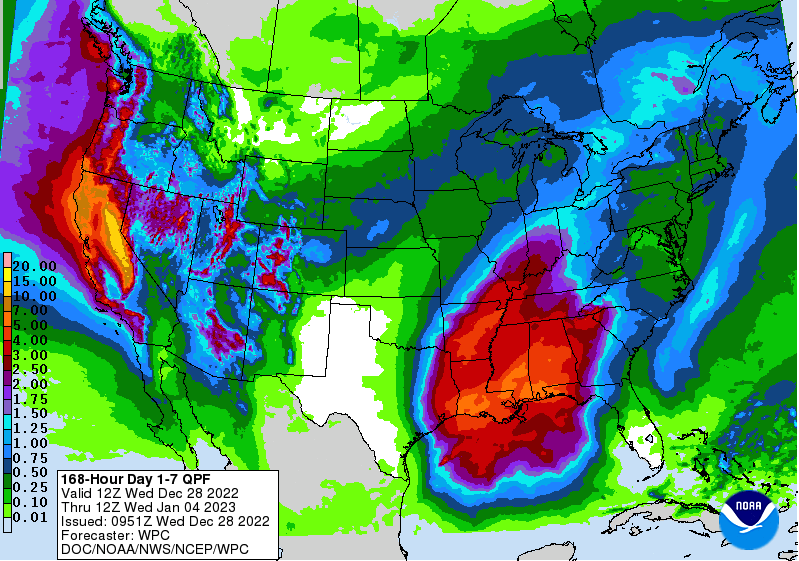
Good morning! After those starts in the single digits to low teens, mid 20s to low 30s almost feels "warm". Nonetheless, a beautiful day is on tap, with plenty of sunshine and highs in the upper 40s and low 50s (average). Looking at the latest satellite scan (10 am), sunny skies will continue to prevail. I will note something neat to our north: most of that white across Western and Central Kentucky is actually lingering snow. It is challenging to distinguish clouds from snow on a still image, but take my word, there's more snow than clouds to our north and west. Looking ahead, dry conditions will hang on through at least Friday morning, before an approaching low and cold front bring rainfall to the area. WPC is highlighting a low end risk for flash flooding across the southern valley Friday night, but I think the risk is very low for all overall. The system should be fairly progressive, generally dumping moderate rain at times Friday night and into the first half of the day Saturday. Soundings do indicate a convective component, meaning a few thunderstorms will be possible as well. If this happens to be the case, then we could see where a low end threat of flash flooding is possible. As it stands now most can expected between a tenth and half an inch, but locally higher amounts within any thunderstorms is likely. This system will be one of a few into the new year, so flooding/flash flooding concerns do grow after this weekend and into next week. This is the 7-day rainfall outlook from WPC, where 2-3" is possible now through next Wednesday. The axis of better rain, for now, appears to be off to our south and west, but is something we will monitor moving forward. Blocking high pressure off the SE coast will allow for an active and wet pattern for at least the first week of the new year which could lead to hydro related issues. For now, impacts are very low and we will have more confidence and details as things better come together. Enjoy the warming temperatures and sunshine today and tomorrow. Cloud cover moves back in Friday, leading to showers early into the weekend. For now, things look dry enough to enjoy any New Year's plans Saturday night and into the day Sunday. Have a good one and don't forget to follow on Twitter and Facebook if you haven't already. Pre-recorded for 5pm weather broadcast
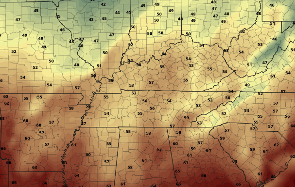
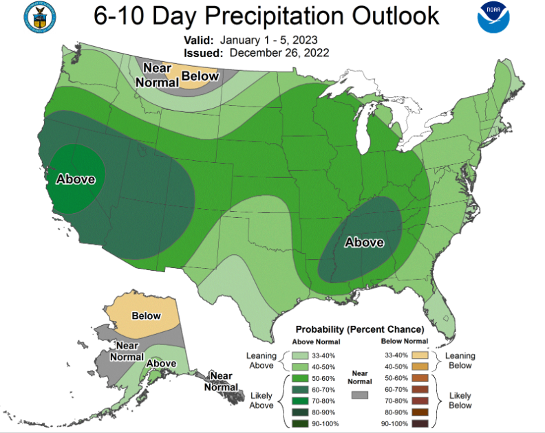
A weak upper disturbance brought some light snowfall for many yesterday, resulting in accumulations ranging from nothing up to 1.5". The Plateau and foothills took the brunt of the higher totals, but most valley locations did start the day with white on the ground. With below freezing temperatures, snow did stick to some roadways causing issues last night and again this morning. For those heading out or planning to, take your time and account for delayed travel times. After a 4-day sub-freezing streak, we finally have some warmer air working in across the region today. High pressure will gradually shift east through the SE this week, allowing for warmer air to advect (move in) in from the south. Highs today will generally top out in the lower 40s, with highs tomorrow climbing into the upper 40s and low 50s. Check out Friday afternoon, as highs likely find the mid 50s or warmer. With the high to our SE by weeks end, not only will warmer temps move in but also increasing moisture. A low pressure system and associated cold front will shift east out of the lee side of the Rockies, allowing for showers to overspread the area by Friday night and into the weekend. Temperatures are expected to stay near to above average though, generally in the 50s to near 60 for some through Saturday. Post front, cooler air (40s) returns on Sunday, but only temporarily, as things warm right back up next week. Looking further out, an active stretch of weather is expected into the new year. We mentioned system number one into this weekend, but a blocking high just off the coast of Florida will favor increased activity across the Tennessee Valley. Several waves of low pressure and associated boundaries could bring heavy rainfall and the chance for flooding. Things are far out and there are many details that need to come together, but this is an early announcement of the potential. Nonetheless, showers and above average rainfall looks likely heading into the first week of the near year. That will do it for today. With temperatures climbing to the low 40s this afternoon, snow and ice should melt off and evaporate, limiting some of the reported messy conditions from this morning. Slick spots still remain possible into Wednesday morning as temperatures fall back below freezing overnight, but they will be very isolated in nature. Have a good one, enjoy the sunshine this afternoon, and look forward to much needed warmth through the week. Pre-recorded for 5pm weather broadcast
A weak "clipper" system will bring the chance for light snow showers to flurries this afternoon to early evening. Generally no accumulations expected, though a light dusting isn't entirely ruled out for some in the valley. For those in the plateau and higher terrain, up to half an inch is possible. This shouldn't be too impactful overall, but something to take site off just after Christmas. From here on out, warming temperatures will find us through the week, where showers return to the area late Friday and into the early weekend. Check it all out below: Pre-recorded for 5pm weather broadcast
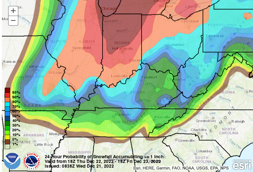
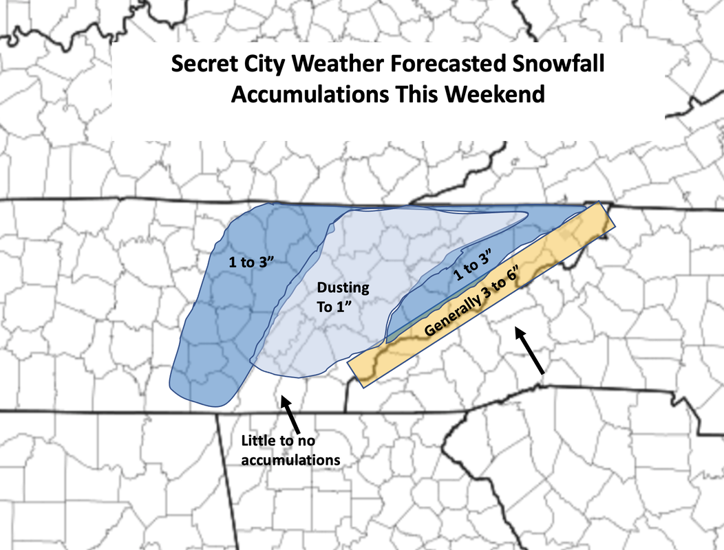
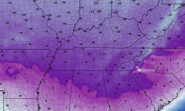
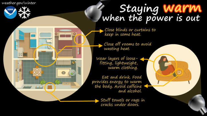
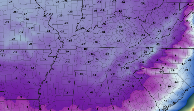
Gusty winds and dangerously cold temperatures will continue through today and Saturday, before a much needed warming trend finds us through the end of the year. We could start 2023 with highs in the 50s to possible near 60. For now, stay warm, limit exposure to the outdoors, and I hope everyone has a wonderful Christmas! The big three remain in play: Icy, Dangerously cold wind chills/Temps, and Light snow accumulations. Check out our video for more details as well as referring to our most previous post. Stay safe, prepare now, and limit outdoor/travel Friday and into Christmas Eve. Details about the upcoming wintry system continue to become clearer. Leading up, we will see increasing cloud cover today where highs find the upper 40s and low 50s. A powerful low pressure system and arctic cold front will develop across the Midwest and spin east over the next couple of days. To our south a weak disturbance will bring the chance for a few isolated to scattered showers overnight tonight, with generally drier conditions in for Thursday morning. This won't last long though, as showers ahead of the approaching front increase across the area tomorrow afternoon, evening, and into the night. With the front crossing between midnight and 5am early Friday (from west to east), temperatures will rapidly plummet. Some locations could fall as much as 30 to 40 degrees in as little as 4 to 8 hours. Given this drastic drop off after a wetting rain, icy road conditions are favorable. This will create issues for any travel Friday morning, so begin to plan accordingly now. Looking at the potential for snow accumulations greater than 1 inch, it is not promising. As usual the valley fairs the worst, while the higher elevations (plateau, foothills, Smokies) have the highest probabilities. As mentioned above, snow is likely with this system. Though amounts vary and there is still some uncertainty involved, they will generally be light for most. The bulk of the valley can generally expect a light dusting to up to an inch. The central valley and south will fair the worst, with snow showers likely for a brief time but little to no accumulations. Outside of here, the Plateau will vary from a few tenths up to 3" and likewise for the Foothills. Keep in mind higher resolution data is beginning to get ingested, so changes will be possible with the snowfall forecast below. Some models depict higher totals than what we have forecast, but I feel warm ground conditions initially, as well as the quick progression of the system will really eat into accumulation chances. Nonetheless, we will continue to monitor trends and provide our latest thoughts. Our third big hazard, outside of light snowfall and icy conditions, will be dangerously cold wind chill values. This will be particularly so Friday and into Saturday morning. With highs only in the single digits and teens Friday (more on this in our video below) and winds out of the west between 15 and 25 mph (gusts 30 to 40), wind chills readings of sub-zero will be common. Some could feel as cold as -20 to -25, which has warranted a Wind Chill Watch from the NWS in Morristown. This will likely become a warning for most by this time tomorrow, so stay abreast to the latest alerts as they come. Lastly, with extremely cold and blustery winds, power outages are likely for some. With fair conditions today, take action now by planning for the worst and knowing what to do is power outages strike. Here is an info graphic below highlighting some of these actions. That will wrap it up for today. We will continue to provide updates via Twitter & Facebook, so be sure to give us a follow @SecretCityWx Another update regarding this system will come tomorrow, likely in the form of a full video briefing, so stay tuned. Plan now for the upcoming cold, address any travel changes that may be needed, and have an action plan if power outages do occur. Pre-recorded for 5pm weather broadcast
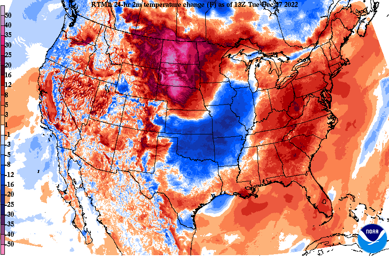
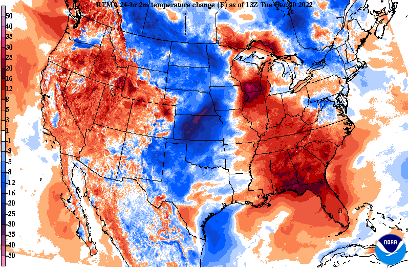
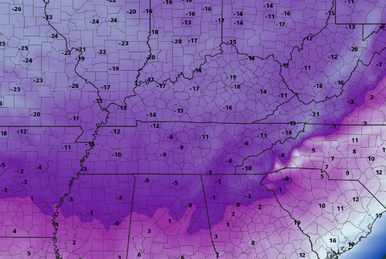
It may have felt chilly this morning, but in actuality it was warmer than 24-hours ago. Cloud cover is thinning out across the area, which will allow for partly cloudy skies this afternoon and mostly clear skies tonight. As you might expect from the warming trends seen below, afternoon highs will be warmer than yesterday, with most in the upper 40s. Pushing ahead, the biggest concern will remain the dangerously cold wind chills and icy road conditions into Friday and Friday night. Looking below, guidance is on track where we could see wind chill readings of -5 to -10, with some locations up to -20. This will be the coldest airmass across the region for the holiday weekend in several decades. Take precautions now to prepare for the extreme cold coming. The coldest night will be Friday night into Saturday, but temperatures won't feel great for most through at least early next week. Breaking down model guidance, things generally remain on track. A powerful storm system will glide east, bringing increasing rain chances through Thursday, before an arctic cold front allows for the change over to snow Thursday night. Temperatures will plummet 30+ degrees during this time, where a flash freeze could be possible. Outside of any snow alone, this will cause problems for any travel conditions, so begin planning ahead for these impacts/delays now. As far as snow chances, our forecast yesterday remains on track. A trace (the site of snowflakes) up to a few tenths remain possible in the valley. The least potential will be in the southern valley, while chances for accumulations grow the further north you go. As far as the Plateau and foothills, generally a few tenths to less than 3" is expected depending on elevation. Higher resolution data is starting to ingest this system, so we will have an even better idea of things this time tomorrow. For now, expect impacts to local commute. Icing will be the largest concern, but light snow accumulations for some also remain possible. Lastly, dangerously cold wind chills of sub-zero are more than likely Friday through Saturday night, so plan ahead for all of these concerns. We will have even more details tomorrow, so check back in. The Christmas forecast will generally be dry (other than maybe a flurry or two), with temperatures in the mid and upper 20s for the afternoon. Pre-recorded for 5pm weather broadcast
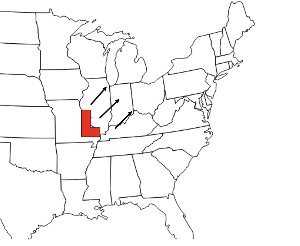
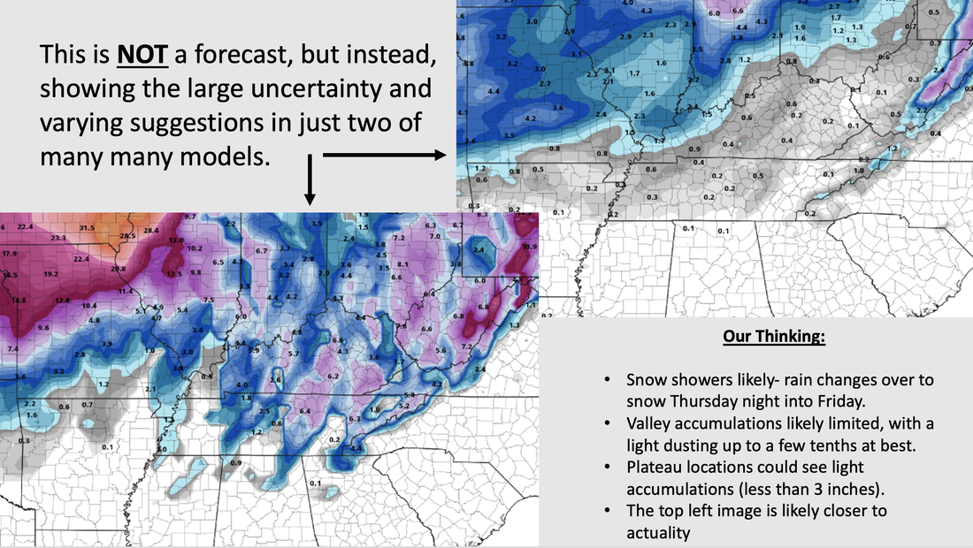
A chilly start for many as 9 am temperatures range from the upper 20s to low 30s. Like yesterday, highs will remain cool as well, generally in the low 40s. Right now partly cloudy skies are present, but increasing cloud cover will lead to broken and cloudy skies by this afternoon. Warmer conditions will find us tomorrow and Wednesday, where mid and upper 40s (and even a few 50s on Wed) are likely. Looking ahead, I am sure many of you have seen or heard a big change is coming. We touched on this several times last week, but confidence is growing and a better picture is set for later this week. A strong area of low pressure and an arctic cold front are going to pivot through the USA. There are several concerns we will talk about but first, what are the uncertainties? Well, the biggest is on the track of the low and how that will play a roll in local impacts. Below are the three primary options, where the south and eastern most track is favorable for a fair snowfall (option 1). Option two, which is the most likely outcome, is of a rain to snow mix, where snow accumulation potential is light and limited. Lastly, option 3 (furthest north and west) would dramatically limit snowfall potential, with mostly a rain/snow mix and very little to no accumulations. Model guidance, and particularly ensemble guidance, has narrowed in on option 2 (middle path) looking the most favorable, but timing is also another crucial piece of this puzzle. A slightly slower progression has become more evident, but depending on the path this could be favorable for snow chances or have no baring on the situation at all. With all of that said, what do a few of the models say? Well as you could guess (below), it's a largely mixed bag. The GFS is closely tied to path 1 (option 1 above). As mentioned this favors the best snow, but in general is the outlier when compared to other guidance. The European is the least aggressive in snowfall, where the low tracks much further north and west (similar to option 3 above). Ensembles, as well as recent deterministic trends, point to a more middle ground approach. This would generally equate to light snow accumulations for most of the valley, while better chances across the plateau and upper valley (bordering KY). As confidence grows, models converge, and higher resolution data is generated we will have a more exact answer. With snow talk out of the way, how will temperatures fair? Well, we are in for some of the coldest Christmas time temperatures in decades. This arctic front will look to bring a dramatic decrease in temps Thursday night into Friday, where most will be in the upper teens to mid 20s Friday afternoon. Similar conditions will be in play Saturday. Additionally, winds will be blustery, leading to wind chills as cold as -5 to -10 (potentially shown below). The coldest of readings will more than likely come during the overnight Friday and into Christmas Eve morning. Because of this sharp cool off, rain showers through Thursday will quickly change over to snow showers Thursday night into Friday. All snow talk aside, icy road conditions are a big worry, where a flash freeze is possible. This scenario would cause issues with travel/commute, so it is something we will continue to monitor closely. All together the big 3 are icy road conditions, temperatures, and some snow. There remains uncertainty, but confidence is growing. Right now, the best potential for snow is across the Plateau and counties bordering KY, but all fair some kind of chance. Further more, travel impacts are likely. Icy roads look more favorable into Friday as rain changes over to snow and temperatures plummet through the early morning. Stay tuned for further updates to come and be sure to give us a follow and shoutout on Twitter & Facebook @SecretCityWx Pre-recorded for 5pm weather broadcast
|
Your trusted source for everything weather in East Tennessee.
Social Media
|

