|
The forecast largely remains on track. Minor accumulations remain possible in the higher terrain (plateau/foothills), with up to an inch possible in some locations. Elsewhere, the valley will continue to see flakes fly but little to no accumulations are expected. Accumulations anywhere will stay primarily on grassy and elevated surfaces (decks, rails, cars, etc). We dry back up later Saturday, hold dry and warmer Sunday, then start the new year with isolated rain/show as a cold front moves through. Check out our video forecast below for more details into next week. Pre-recorded for 5pm weather broadcast
0 Comments
It is true! You may see some flakes fly over the course of the next 2-days, but depending on where you live, the chances of seeing that stack up are low. Starting first in the valley, a light dusting for some locations (grassy surfaces, cars, decks) is not ruled out, but will not be widespread. Meaning, some could see a dusting, while others just see a few flakes fly and nothing results. In the plateau and foothills, up to an inch is possible. Again, mainly on grassy and elevated surfaces as temperatures will be too warm and snow will melt away quickly. Even so, keep in mind slick spots and take it easy Friday morning and especially Saturday morning if on the roadways. Black ice or light snow accumulations on bridges and overpasses could result. The break down: low pressure deepens to the north and west tonight, before fizzling out as it works through tomorrow and into early Saturday. There will be enough moisture for a few isolated showers to snow showers to be seen late overnight for some, otherwise scattered rain showers are the primary expectation into the day Friday. As temperatures cool (higher terrain quicker than the lower) we will see that transition, where lingering snow showers/precipitation is possible through Saturday morning. Drier air then finds us Sunday, followed by another rain or snow mix scenario on New Year's (chances again low here). A cold core low will look to press through the Tennessee Valley Thursday and Friday, bringing a rain to snow mix. During peak heating expect rain showers, before this transitions to a mix and eventually all snow as temperatures fall Thursday night. Accumulations will vary. As usual, anticipate little to nothing across the valley, while up to an inch is possible in the plateau and foothills. Higher amounts likely in the Smokies. Across the valley, a slushy dusting on grassy and elevated surfaces (walkways, decks, vehicles) are possible. Roadways will be too warm, which is fortunate for us. That said, do take it easy and there could be some slick spots heading to work Friday morning. Check out our video forecast below for more: A soggy Christmas Day is on tap, with lingering showers remaining possible through midweek. Temperatures will remain on the warmer side during this next stretch of days, topping out in the upper 50s to low 60s. This is roughly 10 degrees above average. Find our video forecast below for more details: Pre-recorded for 5pm weather broadcast
Pre-recorded for 5pm weather broadcast
Pre-recorded for 5pm weather broadcast
Pre-recorded for 5pm weather broadcast
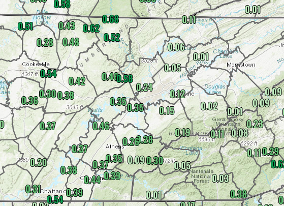
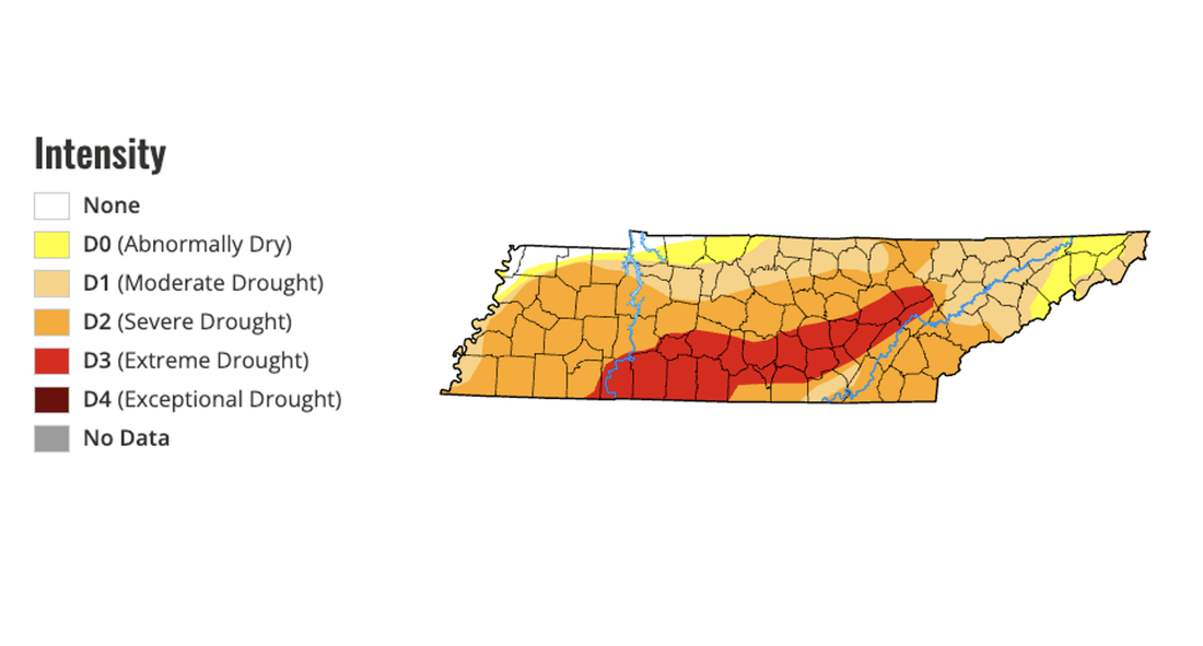
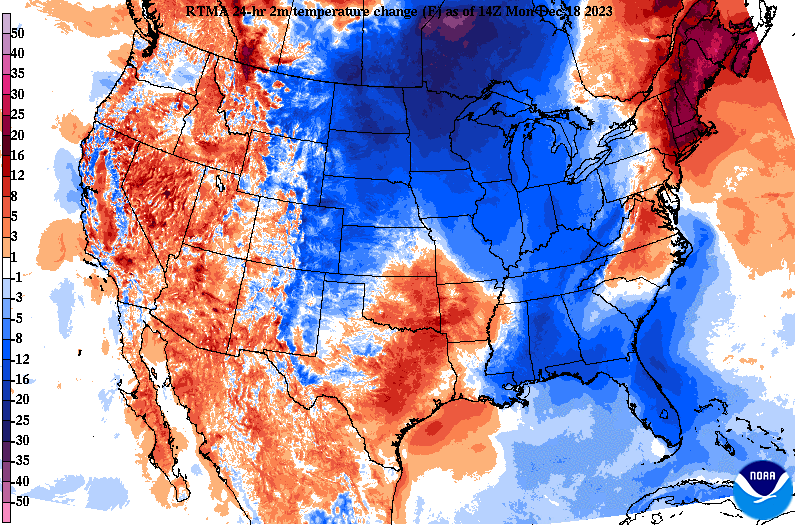
Good morning! After being sparse with updates from being on vacation, we are back. Looking at our latest bout of rainfall, and it was beneficial. Most locations along and west of I-75 picked up between a quarter and half an inch, while those east really varied from a tenth to a few hundredths. Nonetheless, the west was where rain was most needed, so we are fortunate to have gotten that. Moving forward, it's going to be a chilly one (further details below). In response to the rainfall, here is what our current drought map looks like. As you can see, those across the Plateau and through south-central TN are the driest (extreme drought), so the rain was a great thing there. Elsewhere, severe drought still has a grip on the state and more rain is needed in the weeks to come. Moving into the forecast ahead, a cold front is moving through now. MUCH cooler air is being ushered in from the Northern Plains and Canada, where highs will be well below average today and Tuesday. A weak upper level disturbance is passing through the Ohio Valley this afternoon, where a few sprinkles transitioning to flurries will be possible. No accumulations are expected across the valley, but a dusting (on mainly grassy and elevated surfaces/objects) are possible into tonight for the plateau and locations bordering Eastern Kentucky. Those in the foothills and northeast could see up to half an inch, while the highest peaks of the Smokies could see a few inches. Aside from a few snow flakes or snow showers in portions of the area, temperatures will be frigid. Lows tonight will fall into the upper teens to low 20s, with breezy northwest winds making things feel closer to the low teens to even single digits for some locations. Bundle up if heading out early tomorrow, as it will feel very cold to start off the day. Highs will struggle to warm as well, peaking in the upper 30s to around 40 degrees Tuesday. Fortunately, sunshine does return and warmer air will also follow mid to late work week. Highs will climb back to around average by Thursday and last through at least the weekend. Check out our video forecast below for more information. Pre-recorded for 5pm weather broadcast
Stay weather aware this weekend! A strong cold front will pass through, bringing a severe threat followed by a changeover to mixed precipitation. The timing will come Saturday night into Sunday, with some mixed precipitation Sunday night into early Monday. In terms of severe weather, all hazards are possible, with the best chance across the Plateau and Southern Valley. As cooler air trails the boundary and fills in, rain will change to a rain/snow/graupel mix to all snow. The highest eastern terrain (Foothills & Smokies) will be the only locations to see any meaningful accumulation chances. |
Your trusted source for everything weather in East Tennessee.
Social Media
|


