|
Good morning! For those heading out the door, have your umbrellas handy. Also account for some extra travel times with the wet roads and heavy rains resulting in reduced visibilities. This is the latest (8 am) radar scan, with activity heading south and east with time. The good news is this should all clear out by mid morning, setting up partly cloudy skies for the greater portion of the day. Another bout of similar activity looks to return this evening into the night. Some storms could be strong to severe with this (later today) cluster. 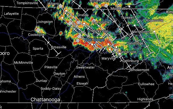 Switching things up a bit, check out the improvement across our neck of the woods. After some much needed rainfall the past couple of weeks, things are starting to veer back to normal. We have lost moderate drought conditions across East Tennessee, but still hold onto a few areas of abnormally dry spots. Fortunately, the unsettled pattern we are in should quickly fix that, with further improvement fully expected in the next release. 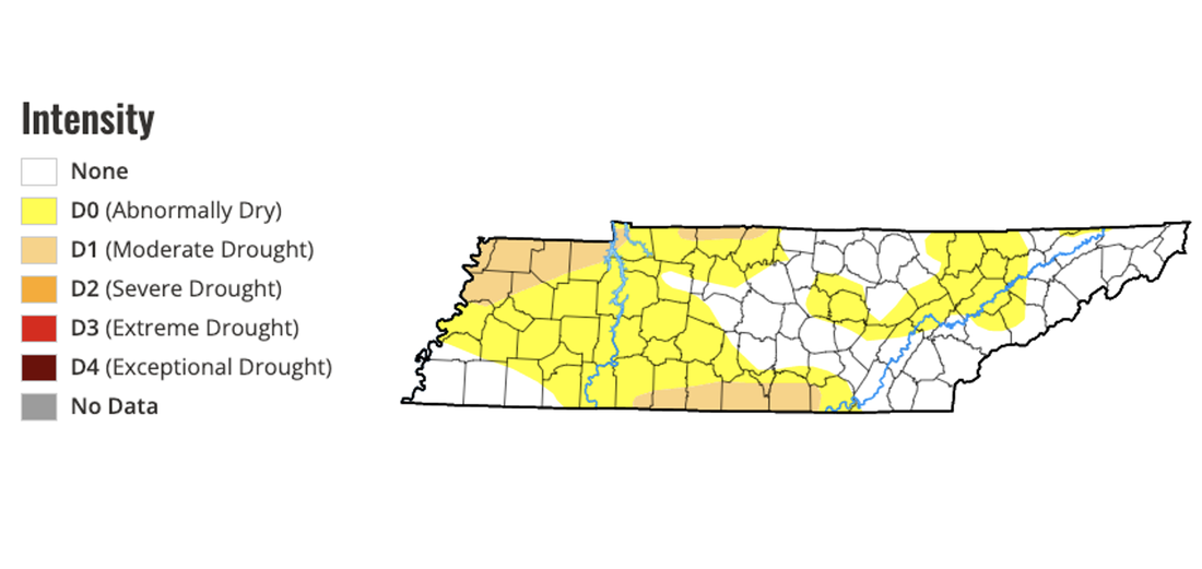 This Week  Previous Week As highlighted above, severe storm chances will haunt us today through Sunday, where damaging wind gusts are the primary threat. That said, large hail also can't be ruled out. Another aspect to this is the flash flooding threat. With rounds of showers and storms over the next few days, this could lead to isolated flooding. This is highlighted below for Saturday from WPC, but a marginal risk encompasses the area today, tomorrow, and Sunday. Our best and most widespread rainfall chances will be Sunday with an approaching cold front. Lingering chances then stick around much of next week as well, mainly during the afternoon and evening hours each day. 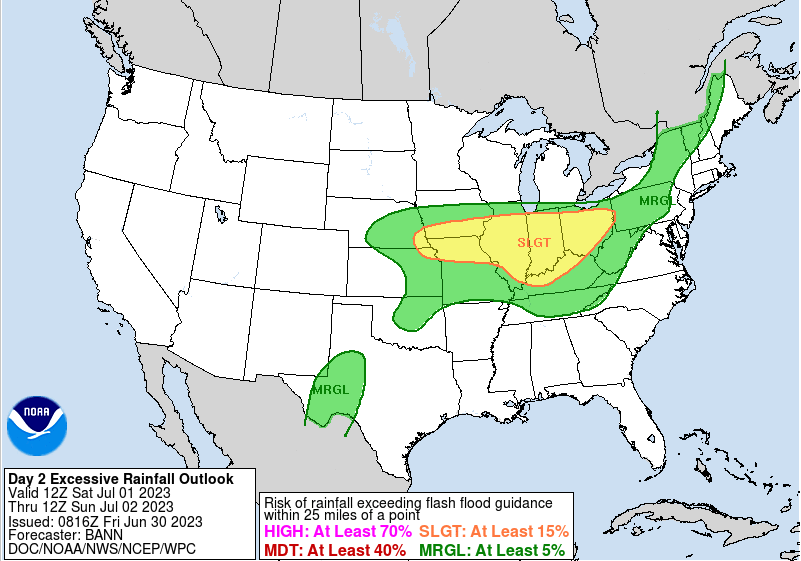 Stay up to date on the latest by following our social media (@SecretCityWx) on Twitter and Facebook. Stay safe, have a way to receive warnings if they were to be issued in the days ahead, and stay cool from the sweltering heat and humidity. Highs will peak in the upper 80s to low 90s today and through the weekend, with feel like temperatures closer to 100 and greater for some (particularly in the south).
0 Comments
Let's talk about the big 3 things that are expected over the next few days. Up first, and probably most obvious, is the smoke/haze across the region. This is being driven down from Canadian wildfires, affecting visibilities along with some health concerns for those most susceptible. The good news is, this will diminish overnight tonight, but we will have to stick it out through the day today. Overall, today will feature partly cloudy to broken skies, with isolated to scattered shower/storm chances (more on this below). Highs will fair warmer, topping out near the 90 mark. 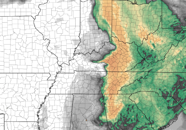 Speaking on temperatures, Mother Nature will be activating summer through Saturday. Warm and moist air will continue to pull in, raising both temperatures and the humidity. Highs tomorrow will find the low 90s for most valley locations (and possibly warmer), with heat indices more like the upper 90s and lower 100's. Given this is our first concerning heat of the year, heat safety will be a topic we will preach through the end of the week. Take frequent breaks, have a way to cool off in the A/C, and drink plenty of fluids. 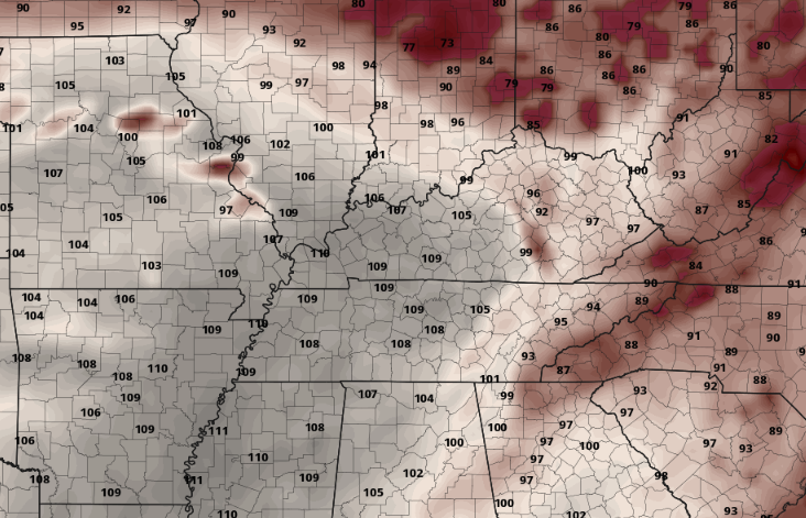 Now it's time for the interesting and challenging part of the forecast: shower/storm chances. A strong ridge (high pressure) sits across the Lower Mississippi Valley but will traverse further east by the weekend. With this in place, a series of upper level disturbances will round the edges of the ridge and bring periodical shower and storm chances. As of right now, the first wave could be this afternoon out of west/central Kentucky. Fortunately, this potential complex of storms will weaken with the push southeast, with activity primarily late this afternoon through early tonight. Following, another complex of showers and storms will be possible Friday, mainly during the afternoon to late evening hours, with yet a third opportunity Saturday. NOTE: there remains a lot of uncertainty in the timing of this activity, and to a degree, if we see much at all on any one of the three days. These are very fine scale driven systems, something that guidance really struggles to pick up on even 12 hours out. That said, the environment will be conducive for strong to severe storms if anything forms, particularly Friday, so be weather aware. A few strong storms can't be ruled out late today as well, mainly for the plateau. Damaging wind gusts and isolated instances of large hail are the biggest threats. Lastly, with showers/storms possible additional cloud cover could hamper higher temperature potential. If activity takes longer to ramp up, temperatures may turn out a touch warmer (particularly Friday and Saturday), so also keep this in mind as well.  With lots of uncertainty in the forecast through Saturday, stay weather aware and tune back in for updates. Follow our Twitter and Facebook (@SecretCityWx) for the latest. After Saturday, a cold front approaches bringing a healthy shot of rainfall chances late weekend, with scattered activity possible thereafter early to mid week. Thankfully, we will be a bit cooler into next week (mid to upper 80s).
Summertime will be in full swing the next couple of days, as very warm and moist air filters in. In addition to the heat, we'll see the UV index at full force, with values exceeding 10 likely for most locations. Keep it in mind, this could be hampered a bit by the haze from wildfire smoke today, but regardless high values still expected. Highs today should peak in the mid to upper 80s under hazy sunny skies. 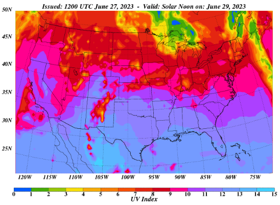 In the days to come, warm moist air will pump in from the south. This will raise temperatures to find the low 90s, while dewpoints will peak in the 60s and 70s. This will result in "feel-like" temperatures in the upper 90s and lower triple digits. Since this is our first bigger heat of the year, keep your heat safety in mind. Rounding disturbances could limit how warm heat indices get, but will still be something to look out for and keep in mind. 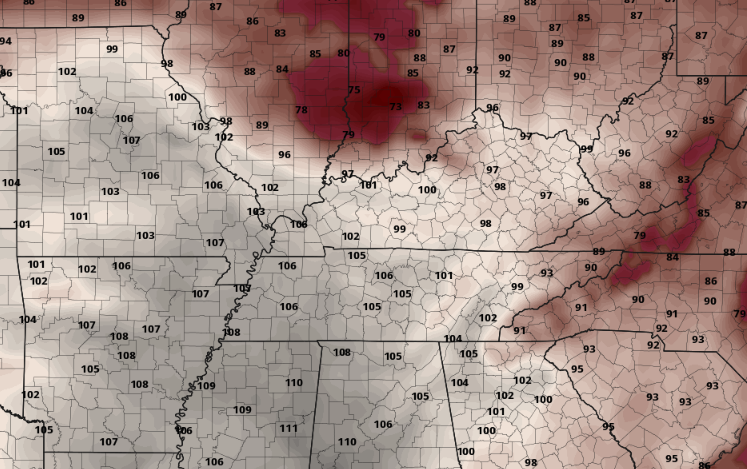 Of those mentioned disturbances, Friday looks to be the most concerning. A wave will round the stout ridge across Texas, bringing showers and storms to the area from the Midwest on Friday. The Storm Prediction Center has included us in a Marginal risk, with the better threat further north. Damaging wind gusts will be the primary threat with any scattered activity, so tune back in for further details ahead. The timing of this activity will come in waves, coming first Thursday afternoon to early night, then again Friday afternoon to the early overnight, followed by an approaching cold front and better chances through the weekend. 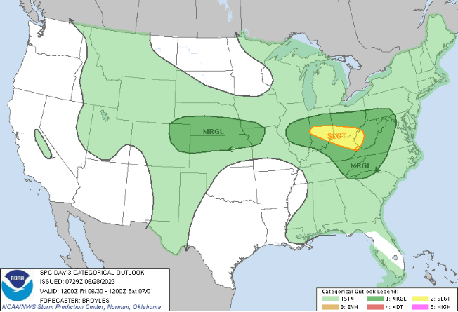 Of note will be the heat and humidity moving forward. Additionally, a few storms could be strong to severe Friday so be weather aware and have a way to receive alerts. Have a good one, stay cool, and stay safe!
A pleasant one in the making today, with temperatures topping out in the mid 80s under mostly sunny skies. Changes are in the works moving forward though, as much warmer and muggier air filters in through the end of the work week. This will lead to pop up showers and storms, some of which could be strong heading into Friday. A slow moving cold front then inches in, bringing rounds of rainfall chances through the weekend. Pre-recorded for 5pm weather broadcast
Good morning! After rounds of showers and storms yesterday and again early this morning, things are starting out calm. We saw our first round of activity early yesterday afternoon with a decaying/weakening meso-convective system. These are fine scale driven systems that are challenging to depict days ahead of time. After that moved through, a line of storms associated with a cold front found its way in late last night/ early this morning. The combination of the two left several power outages and wind damage as depicted below. If you have damage you would like to report, send us an email, comment, or submit to us your location, what happened, time (if known), and a picture if possible as well. These are helpful to the NWS in verifying warnings as well as keeping track for local officials/aid. 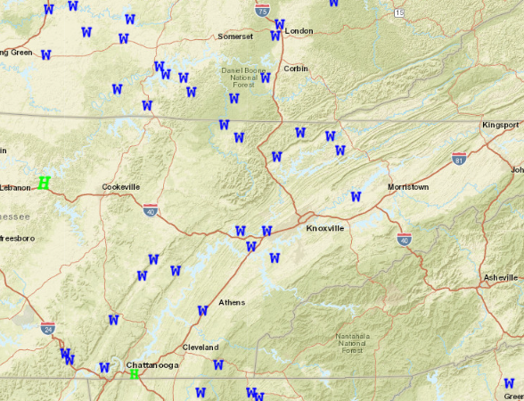 Heading through the week, it'll be a pleasant one. Cloud cover thins out this morning, leaving sunny skies the remainder of today. Similar conditions are set for Tuesday as well, with highs in the mid 80s and sunny. Towards Wednesday, we will take a turn toward a warming trend. High pressure will break east, floating into the Mid Atlantic. As it does so, "return flow" will pull in moisture and warmer temperatures from our south. As a result, it'll be warmer, more humid, and isolated to scattered pop up afternoon showers/storms will be possible Thursday and onward. How warm will things get? Likely the warmest we have seen so far this year. Looking below at guidance, most valley locations will more than likely see low 90s by Friday afternoon, while the higher elevations also seasonably warm in the upper 80s to around 90. This is a good time to keep your heat safety in mind! 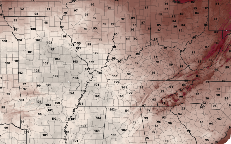 Again, please share any storm damage you might have from yesterday's storms and we will get those passed onto the proper location. These also help us know what is going on and where. Other than that, enjoy a beautiful Monday and first half of the week, before much warmer and stickier air finds us late week into the weekend. Pre-recorded for 5pm weather broadcast
Showers continue to diminish today as the low pulls further north and east. This will set up a pleasant weekend, with partly cloudy skies and warming temperatures. Highs will find the mid to upper 80s. Though an isolated shower or storm can't be ruled out, most veer dry through Saturday and much of Sunday. That said, a cold front approaches Sunday night into Monday, bringing a line of showers and storms. Some of these could be strong to severe, with damaging winds the primary threat. All hazards will be possible. The positive with this is in timing. The overnight hours will cut down on usable/available energy, lessening our severe threat. We will keep a close eye on this moving forward. Stay up to date by following us on Twitter/Facebook @SecretCityWx A cool morning overall, with most in the upper 50s to low 60s. We will warm a bit more by this afternoon, but with dense cloud cover and shower activity, most will only find the low to mid 70s. This is several degrees below average. Looking below, morning showers have really played a role in temperatures, where most locations are 5 to 10 degrees cooler than this time yesterday.  It should not come as much of a surprise as rounds of rainfall in recent days has really moistened up soils across the area. We have had on going rainfall this morning, which should continue at times throughout the afternoon. That said, rainfall rates have been on the lighter side thus far and will minimal "energy" to work with, thunderstorms will not be anything too crazy. This should limit heavy rainfall rates and flash flooding potential, but we are not out of the woods entirely for flooding risks. The good news is moving forward activity dwindles tonight, with mainly scattered activity the first half of the day tomorrow. Generally drier and warmer air then builds in throughout the weekend, before another shower & storm chance early next week.  Looking elsewhere, the Tropics remain active. Tropical Storm Bret is expected to work towards Central America in the days to come, while Tropical Depression 4 is working not too far behind. This depression will be the one to watch, as it strengthens over the next 24 to 48 hours into a Tropical Storm or greater. Current forecasts depict this working northwest, towards the Bahamas and possibly the USA. We are still several days out, but something to look out for if there is family, friends, or a vacation plans in the south. Check back in for updates in the days to come. 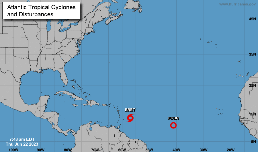 Showers will remain hit and miss throughout today, with activity more scattered through Friday. Some needed drier and warmer air then returns Saturday and Sunday, followed by another round of showers and storms early next week.
Pre-recorded for 5pm weather broadcast
Up first, the Tropics! We have started the season active, where Tropical Storm Bret has now formed. This is expected to drift northwest, heading for the Caribbean. With so much distance and time for it to track, there is uncertainty where this will head, but early indications suggest towards Central America/Mexico. Nonetheless, we will keep you updated on this formation, with a secondary area of concern just off the coast of Africa. 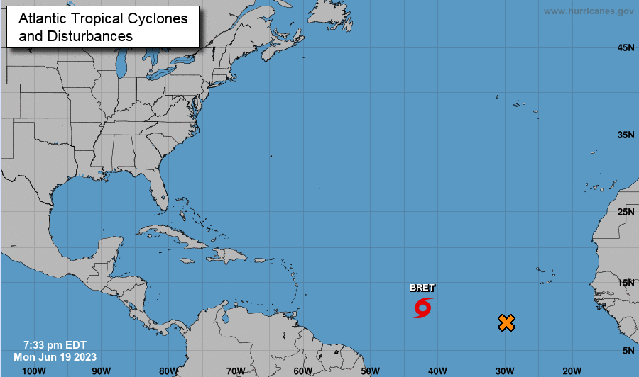 The big highlights locally will be the persistent rainfall. An area of low pressure is overhead now, looking to bring rounds of showers and storms today. Areas that saw heavy rainfall yesterday will be the most prone to flash flooding, so have a way to receive alerts if these warnings are issued. Some locations saw as much as 2.5" of rainfall yesterday, while others rounded out near half an inch. Similar circumstances are in the forecast toady, where the heaviest of rainfall should be confined to the Foothills and Smokies. As you can see below, a few more inches of rainfall is in the forecast through late weekend, where some locations could see as much as another 3-4". Take precautions now and have a way to receive alerts, as the flash flooding risk grows by the day. 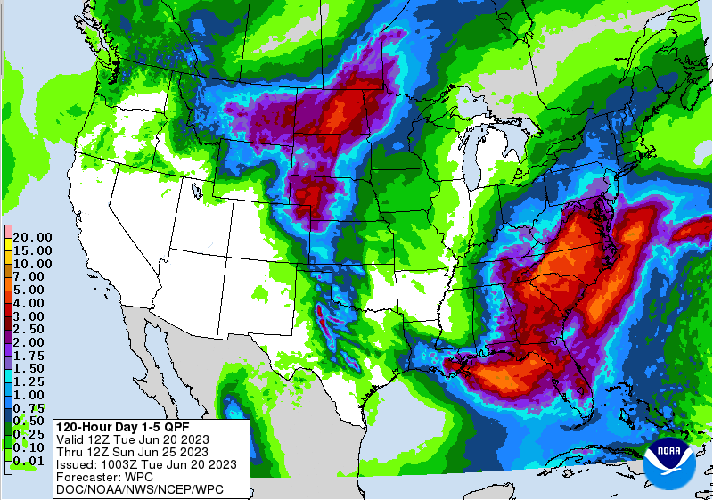 Showers and storms should diminish into the overnight hours each day, with the highest chances during the afternoon and evening hours. Guidance depicts this system to exit a little quicker as it builds back north late work week, meaning dry weather could return as soon as Saturday evening or Sunday. Until then, have the umbrellas handy as waves of showers and storms are forecast with temperatures in the upper 70s to low 80s. Pre-recorded for 5pm weather broadcast
An unsettled and active stretch expected much of this week, so have the rain gear handy. Isolated flash flooding will be possible, particularly in locations that see repeated activity and/or heavy thunderstorms. Take precautions now if in flood prone locations. Rainfall amounts through Friday will vary between 1-3", with locally higher amounts possible. Pre-recorded for 5pm weather broadcast
|