|
We will close out the last post for the week highlighting Sunday into early next week. We have been monitoring the evolution of a disturbance that will bring rounds of rainfall Monday-Wednesday, but some better trends have shown. That said, let's start with what WPC suggests Monday into Tuesday. As you can see below, a slight (Day 4) risk of flash flooding remains present across the SE, while the remainder of the area is under a marginal. 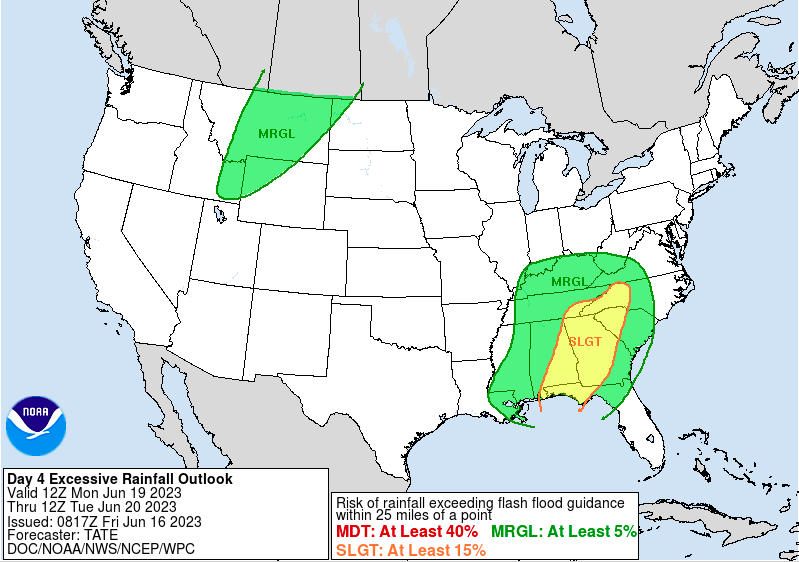 This seems sufficient for a worst case scenario, as the south and southeast will more than likely see the most rainfall overall. Amounts as of this morning look to vary between 1.5-2.5" - a trend toward lesser amounts since yesterday and there's a reason (follow below). That said, large scale models do a poor job at picking up on smaller scale features/details so instances of thunderstorms (slow moving or strong, along with subtle boundaries and more) won't be properly ingested here. As such, amounts will vary with localized higher amounts likely. 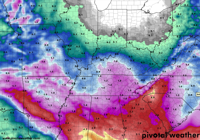 Now, on to a positive trend. What we have been watching is an upper level disturbance working in from the Central Plains. This feature, boxed in below, develops in the Mid Mississippi Valley and gradually works its way through the Tennessee Valley and then south. Previous data suggested this to stall out along the Appalachians or slowly shift towards the Mid Atlantic into midweek. Recent trends veer this towards the Gulf, which would result in a lesser influence, and thus, lesser rainfall. Assuming this trend holds that would lessen our odds of heavy and/or repeated rainfall and the overall flash flooding threat. We will keep an eye on things through the weekend, but this is a positive sign.  So what about this holiday weekend? Well, it is going to be a mixed bag! Most will stay dry today with sunny to partly sunny skies and highs in the mid 80s. High pressure builds in for the day Saturday (dry and mild), followed by a warm front and approach of the mentioned low pressure system. This will raise highs pretty significantly Sunday, where most top out in the upper 80s to low 90s. Showers and a few storms will also be possible late afternoon and into the night, with widespread activity planned on Monday. As this system weakens and tracks south of the area towards midweek, shower chances become widely scattered.
For more information as it's released along with further weather updates across East Tennessee, follow Secret City Weather on Twitter and Facebook (@SecretCityWx)
0 Comments
We'll start off with what's planned today through Saturday: Partly cloudy skies will prevail today and Friday, where hit and miss (isolated to widely scattered) showers and storms are forecast. These will mainly be during the warmer hours of the day. By Saturday, high pressure fills in, giving us a brief pause from precipitation chances (take advantage for the start of the weekend!) Thereafter, things take a turn. A slow moving approaching low pressure system will bring shower and thunderstorm chances starting Sunday evening and lasting through at least the first half of the work week. Guidance sets up what we call a "blocking pattern." This means the low will get blocked off, essentially stalling out across the Appalachians. As it does so, repeated rounds of showers are possible and could cause issues with water basins and flash flooding concerns as a whole. As of right now, there is uncertainty in the strength and residence time of the system, but check out rainfall totals through Tuesday evening. Keep in mind, changes are likely as better data comes in, but 2-3+" look to be on the horizon if trends hold. Additionally, guidance does not account for smaller scale details, which will become very key in flash flood potential. For now, know Sunday into next week will be active and something you should check back in/monitor. 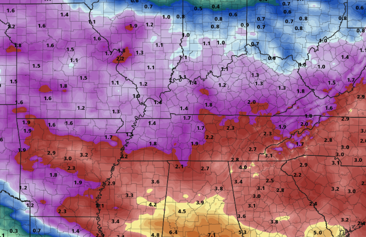 It is not very often the Weather Prediction Center throws out a Day 5 slight flash flooding risk, but that's exactly what they did today. Again with the mentioned concerns above, river flooding and/or flash flooding are in the realm of possibilities if things materialize as guidance suggests. 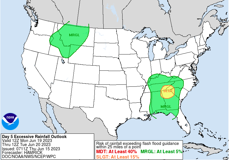 Longer term, late next week, a cooler pattern takes hold. This makes sense as cloud cover and showers will limit heating during the day. Even further out (not depicted) a similar "cooler than normal" trend seems possible- as suggested by the Climate Prediction Center. 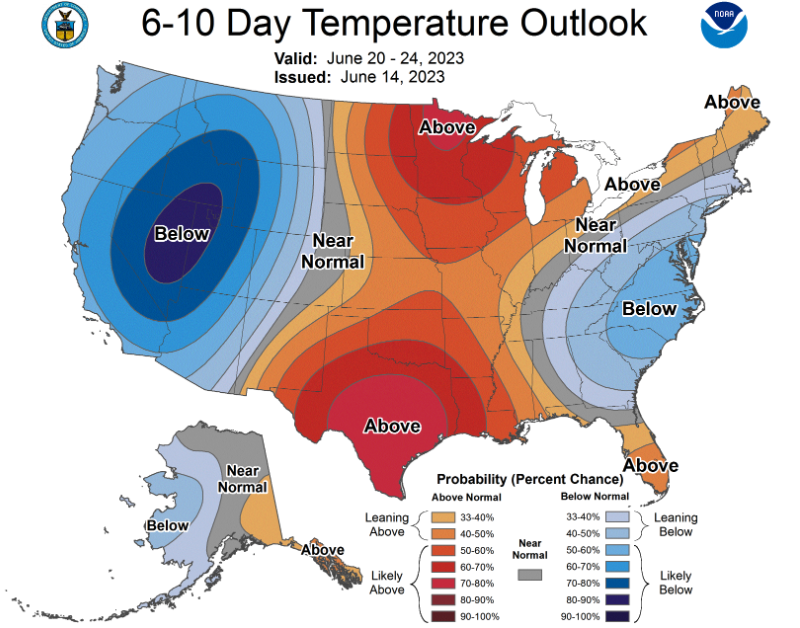 Be sure to check back in tomorrow and this weekend, as we will have more details on rainfall Sunday into next week. As of now, things look increasingly likely several rounds of showers and storms are in the forecast during this timeframe and some hydro (and possibly some severe weather) related issues could arise. Pre-recorded for 5pm weather broadcast
9:30 am temperatures were warmer than this time yesterday, as highlighted below, with most in the mid to upper 60s. Warmer highs will also result, with upper 70s to low 80s forecast. There will be some question on how much influence cloud cover and showers/storms could have this afternoon. Where thicker coverage will result in lower highs. Nonetheless, most should achieve this range. As for the forecast, a mix of clouds and sunshine is expected. Those furthest north will fair the best (more sunshine & lesser chance for showers) while those further south (nearer to GA/AL) will see the most cloud cover and highest chance of activity. In fact, Chattanooga has showers passing through now (9:30 am). Better weather conditions will return Thursday, where most see partly cloudy skies for the day. An isolated shower or storm will be possible both tomorrow and Friday, but low in chance.  Turning focus to our most recent bout of needed rain, check out totals. Keep in mind moderate drought has developed across the heart of East Tennessee, so this rainfall was very beneficial. By the numbers, most picked up an average of 1 to 2 inches, but locally higher amounts were seen in the northern plateau, up to 3 inches. We could see another bout of heavy rainfall and/or strong storms by late weekend into early next week (follow below). 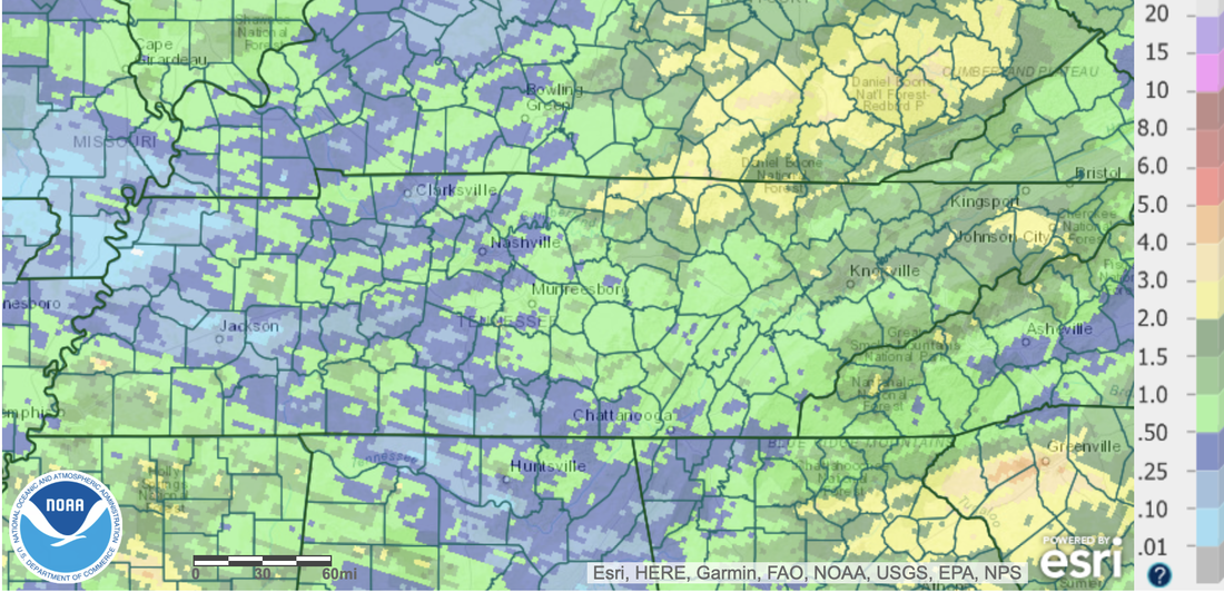 An approaching low pressure system and front will allow for widespread showers and storms late weekend into next week. As we mentioned yesterday, there is still uncertainty in the timing and strength of this system, so some changes are likely. In fact, since yesterday a slower trend was noted, hence why better shower chances have been moved to Sunday & Monday versus late Saturday into Sunday. We will monitor this closely, as strong storms and heavy rainfall appear increasingly likely. Check back in with us for more details in the days to come. 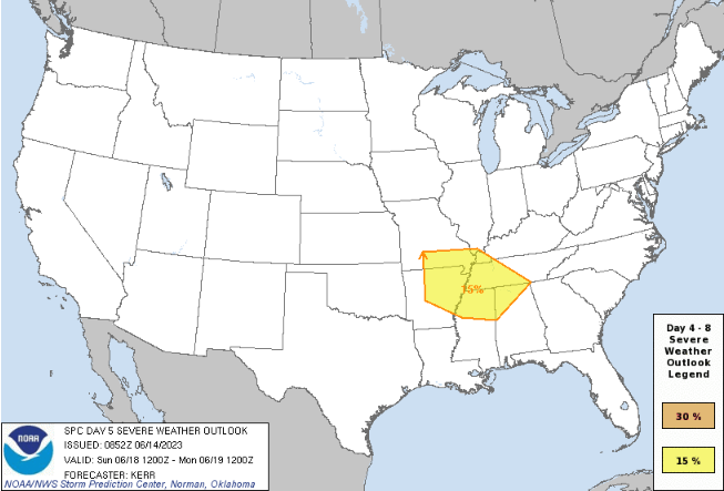 Conditions today are a mixed bag, with some seeing cloud cover and on and off showers, while others fair partly cloudy with more limited rainfall chances. Either way, better conditions are in store for all tomorrow through Saturday, with limited shower potential through this time. Pre-recorded for 5pm weather broadcast
Good morning! Patchy fog has burned off and that's paving the way for a gorgeous day. Looking at the most recent view across the Smokies (10 AM), sunny skies are filling in nicely. This will be the trend for most today, though the southern valley (nearest to GA/AL) could see some better cloud and shower potential. It will be low chance nonetheless, but something to keep in mind. Elsewhere, mostly sunny to partly cloudy and mild with highs in the mid to upper 70s. 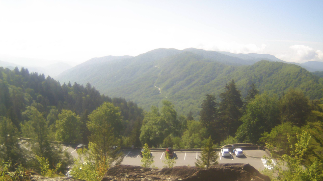 With mostly sunny skies in place, a light haze will remain possible in the far horizon. Reason being? You probably already guess it but Canadian wildfire smoke. It will not be nearly as dense as it was last week, but in case you are curious, now you know. 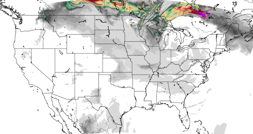 Moving forward, unsettled weather returns for Wednesday. A stalled boundary just south of the area will combine with rounding disturbances to bring shower and storm chances each day moving forward. Scattered showers and storms find us Wednesday afternoon to evening, some of which could be strong (gusty winds/small hail). Lesser chances find us Thursday, Friday, and the first half of the day Saturday, but a shower or storm can't be entirely ruled out. Saturday night another shot of rain arrives, but chances will be much higher. A low pressure system and cold front will look to target the area, bringing the return of widespread showers and storms. Rainfall amounts at this time look to vary between 1 and 2" but there is still some uncertainty in strength, path, and timing. This system could pose another round of strong to severe storms along with a flash flooding risk late weekend. Stay tuned for further updates with better details.  That will wrap it up for today! I hope everyone enjoys a little sunshine and mild temperatures before hit and miss showers return Wednesday and last through the end of the work week. Widespread showers then follow later Saturday into Sunday. Pre-recorded for 5pm weather broadcast
First on the plate are the storms from yesterday....most locations saw both heavy rain and strong storms at one time or another Sunday afternoon/evening and this image below depicts that. This is an unofficial review of reports at NWS Morristown, where several hail and wind damage data was submitted. Fortunately, no big threat for severe storms in the next few days, but better chances for showers and storms does appear on the horizon towards the weekend. For now, confidence is low on anything strong but something we will monitor through the week.  Taking a few steps back now, check out the latest drought map across the state. Prior to yesterdays soaking rain, many were inches of rain behind when compared to 30-day norms. As a result, abnormally dry and moderate drought has popped up for portions of the state. The good, and obvious news, changes are coming ahead. Heavy and widespread rainfall yesterday has allowed for things to catch back up a bit, so I expect some improvement to this map later in the week. That said, we are still behind in rainfall numbers and will need more in order to catch back up to averages. 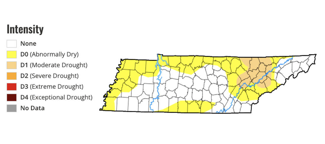 Moving forward, a stagnant low to our north and a series of passing upper level disturbances will keep rain chances in the forecast. A weak high will press in tonight, leaving dry conditions this afternoon through the first half of the day Tuesday. Into Tuesday afternoon and evening, isolated to scattered shower/storm chances return, with a daily afternoon to evening threat planned each day this week. These will be the usual hit and miss shower/storms, with activity dissipating into the nighttime hours each day.  That will wrap it up for todays forecast. Overall, it's going to be cooler today with the passing of yesterdays front. Most top out in the mid 70s, but warmer air is to come in the days ahead. We will find the mid to upper 80s by the end of the work week (Friday). Lastly, it is mostly cloudy for many now but coverage will scatter out into this afternoon, where most end up partly cloudy through the remainder of the day. Enjoy! Pre-recorded for 5pm weather broadcast
Other than some patchy fog lifting out this morning, we start cool and crisp for early to mid June standards. Fortunately, we will warm nicely into this afternoon, with highs topping out in the upper 70s to low 80s under mostly sunny skies. Dry weather will stick around through Saturday, before showers & storms return Sunday into Monday. 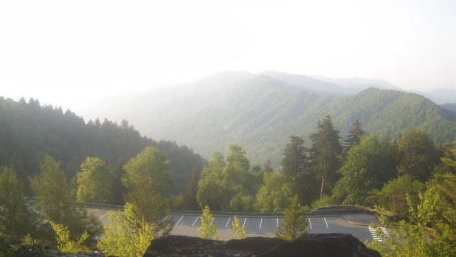 Analyzing the threats, a Slight risk of flash flooding is in place across much of the state. WPC suggests this to be a higher end potential given some guidance, but for now, I am downplaying this myself. Reason being, some of the suggested guidance are more outliers when compared to the mean, we are running fairly dry in many spots (with drought across many East TN locations), and the better support is further west. That said, isolated heavy rainfall within storms could lead to an instance or two of flash flooding and it is a threat we need to keep in mind Sunday afternoon into the night. 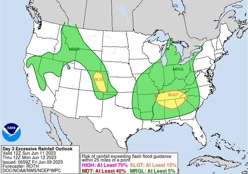 Additionally, a risk for severe storms is present (1/5 on the risk scale). Again, the better support will be further west, but a few strong storms will be possible Sunday afternoon to evening where strong to damaging wind gusts are the primary concern. Of the two threats, I believe the severe threat is of a higher potential, though national federal centers obviously differ in this opinion. We will see as better guidance comes in today and Saturday, so tune back in to our social media for the latest. 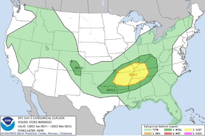 Temperatures will fall down into the 70s to low 80s Monday with the passing front, where briefly drier air returns Monday night. This won't last too long though, as isolated to scattered shower/storm chances will be possible each afternoon to evening this upcoming week. Check out our Twitter/Facebook page (@SecretCityWx) along with our video forecast below for more. Pre-recorded for 5pm weather broadcast
Good morning to all! With our last bout of rainfall (for some) foggy conditions have started the morning off. As such, please use caution on your way out the door. Reduced visibilities are likely, so account for slower travel times for the morning commute. By this afternoon, sunshine should return, leaving highs to find the mid to upper 70s. 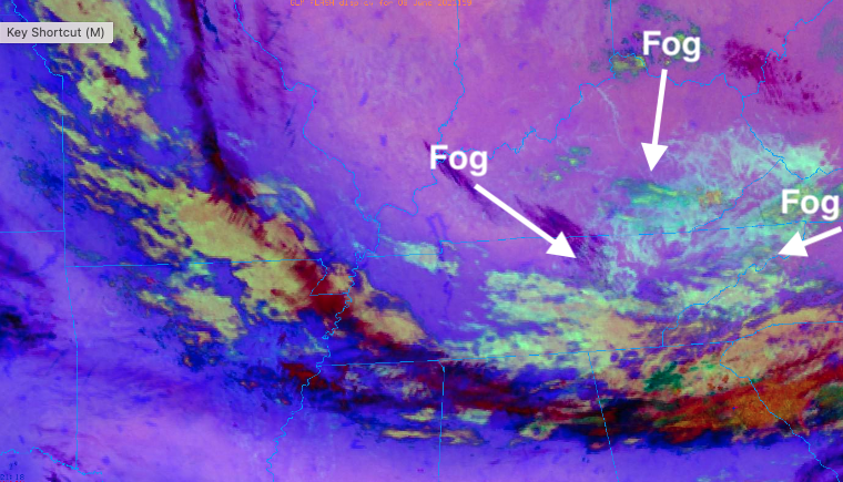 Something we have discussed a little earlier in the week is smoke. With hundreds of Canadian wildfires on-going and no end in site, dense smoke, reduced visibilities, and health concerns have been roaming around in the news. This is particularly so in the Northeast. Fortunately, with our last system, some changes are in store, where reduced smoke appears likely for some. That said, those closest to the fires in Quebec and Ontario will remain at risk, with higher chances as we work into the weekend. For now, we will steer clear, as depicted below, with portions of PA, Western NY, and sections of the Mid Atlantic at the highest risk today. 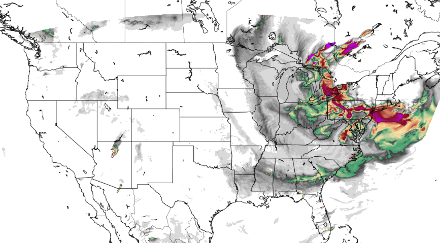 Though we look to stay dry and mostly sunny this afternoon through Saturday, rainfall chances do creep back in late weekend. An approaching disturbance will look to bring widespread rainfall to the area, with most picking up between a quarter to half an inch. The image below is what the Weather Prediction Center has forecast, which seems a little aggressive at the moment but something we will watch for. Nonetheless, rainfall will be beneficial to the drought introducing itself across the state, so it will be a welcomed site. For now, storms will generally remain sub-severe but a few strong storms and heavy rain makers are definitely possible. 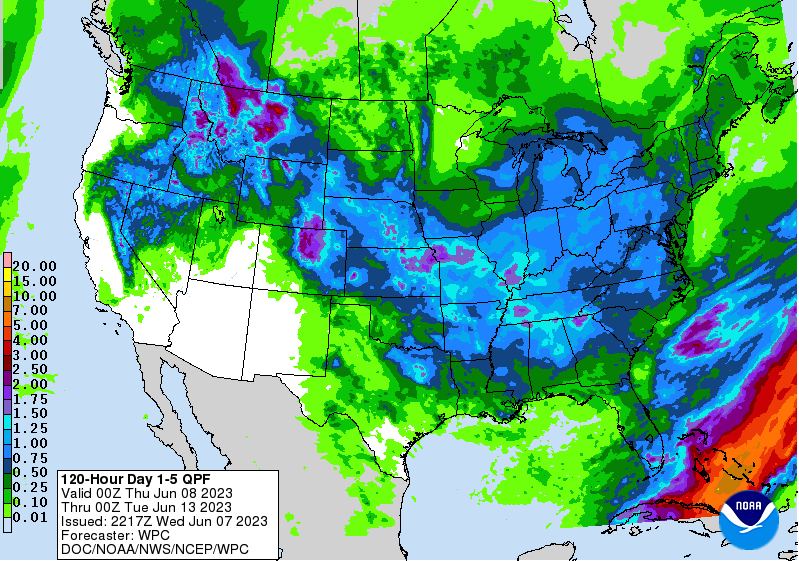 That will do it for today, enjoy the sunshine this afternoon and to come. Showers and a few storms arrive late weekend, with drier air to fill back in towards mid-week. Temperatures will warm in the days to come as well, with highs Saturday in the mid 80s. Pre-recorded for 5pm weather broadcast
Good afternoon! Looking at radar, showers continue to fill in. Activity will generally stay confined to light to moderate intensity, but a few thunderstorms can't be ruled out. These are a welcomed sight given the dry conditions the past few weeks, where up to a half an inch will be possible. Locations in the northeast and bordering KY will have the highest amounts, while those south and west (southern valley and plateau) will fair the least. 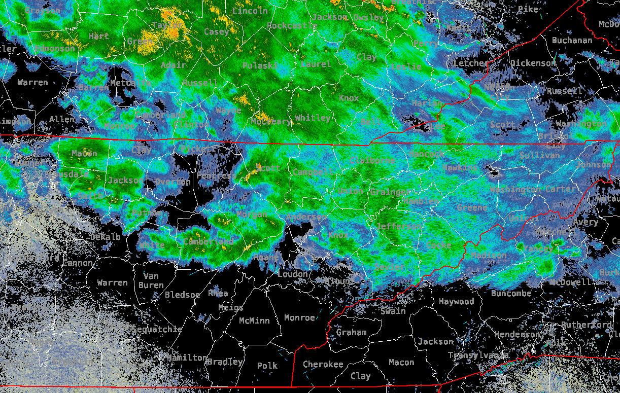 In terms of temperatures, cloud cover and rain cooled air has really impacted things. Most central valley locations sit in the mid 60s, while those who have been sunnier thus far have warmed into the 70s and even 80s. This quite a bit of disparity, all dependent on the cloud coverage. 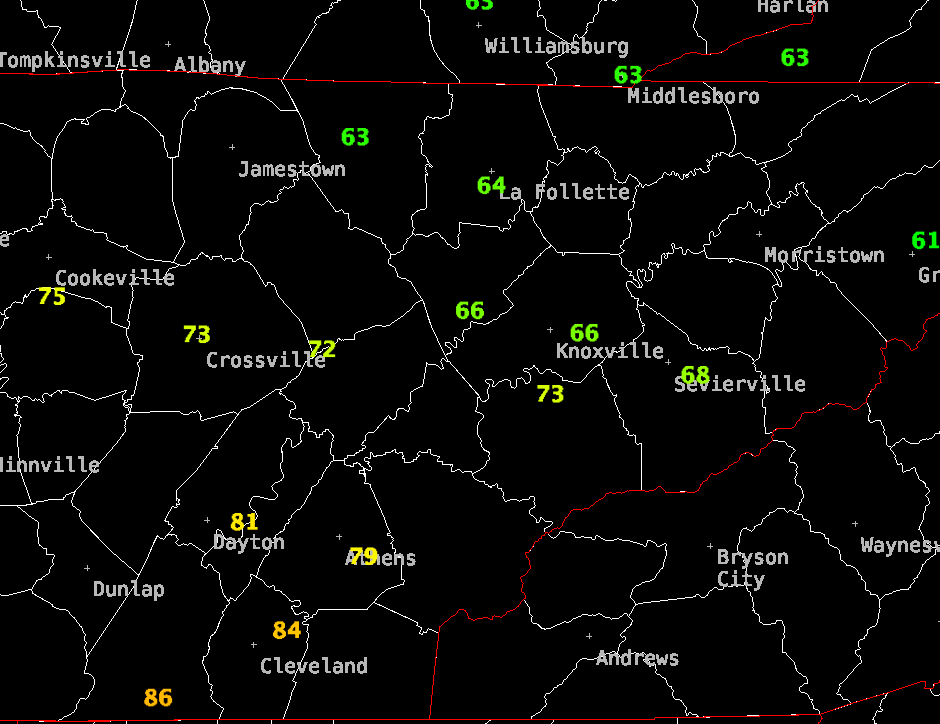 For what's to come...hit and miss showers continue through early tonight, where cloud cover will slowly break up by early Thursday morning. This will allow for high pressure to fill in behind a cold front, and sunny skies to arrive Thursday afternoon through Saturday. Temperatures will also fare cooler for all tomorrow (upper 70s to around 80), before we warm through the weekend. Another bout of shower and storm chances return late weekend into early next week with our next disturbance.  I hope you have the umbrellas handy today. Showers will be hit a miss through the remainder of the day, with sunshine to return in full force tomorrow afternoon through Saturday. Have a good one, enjoy the pleasant weather to come, and don't forget to follow us on Twitter & Facebook @SecretCityWx Pre-recorded for 5pm weather broadcast
Here is a test: Find a ridge or object that is typically several miles out and ask yourself if it looks abnormally hard to see/hazy. The answer is likely yes, and the reason? Smoke from Canada. Looking at the Smokies below, the name is very fitting. As you can see, very "smoky" or hazy views are present and will be all day. 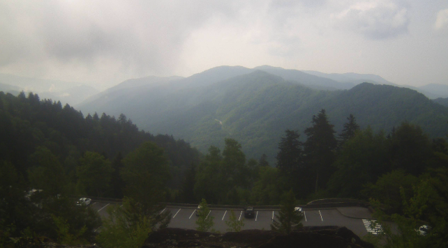 Looking at a smoke dispersion model, dense smoke looks likely into this afternoon, which could impact those who are sensitive health-wise as well as visibilities. We should begin to clear out through Wednesday, with rain back in the forecast. Temperatures today could be affected by the smoke, where reduced highs in the mid 80s seem favorable. Large wildfires in Canada are the cause of what we are seeing/experiencing today. 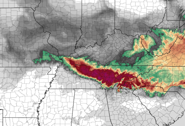 Looking at our next opportunity for rain, a slow moving cold front dips south tonight. As it does so, cloud cover will increase late and scattered showers will eventually result for Wednesday. A few storms also can't be ruled out. Unfortunately, not everyone will see rain and if they do, not in large numbers. The highest amounts will be across the Northern Valley/Plateau border KY and across the far northeast. Chances in rain and amounts decrease the further south and west you are. Nonetheless, this will be a helpful rain to our increased drought, but not something to sustain us very long.  By Thursday, a cooler and drier airmass fills in. This will leave us mostly sunny and dry Thursday through Saturday, before better shower chances return Sunday into early next week. Take a look at our video forecast below for more information as well as examples of the smoke across the region. Pre-recorded for 5pm rather broadcast
|