|
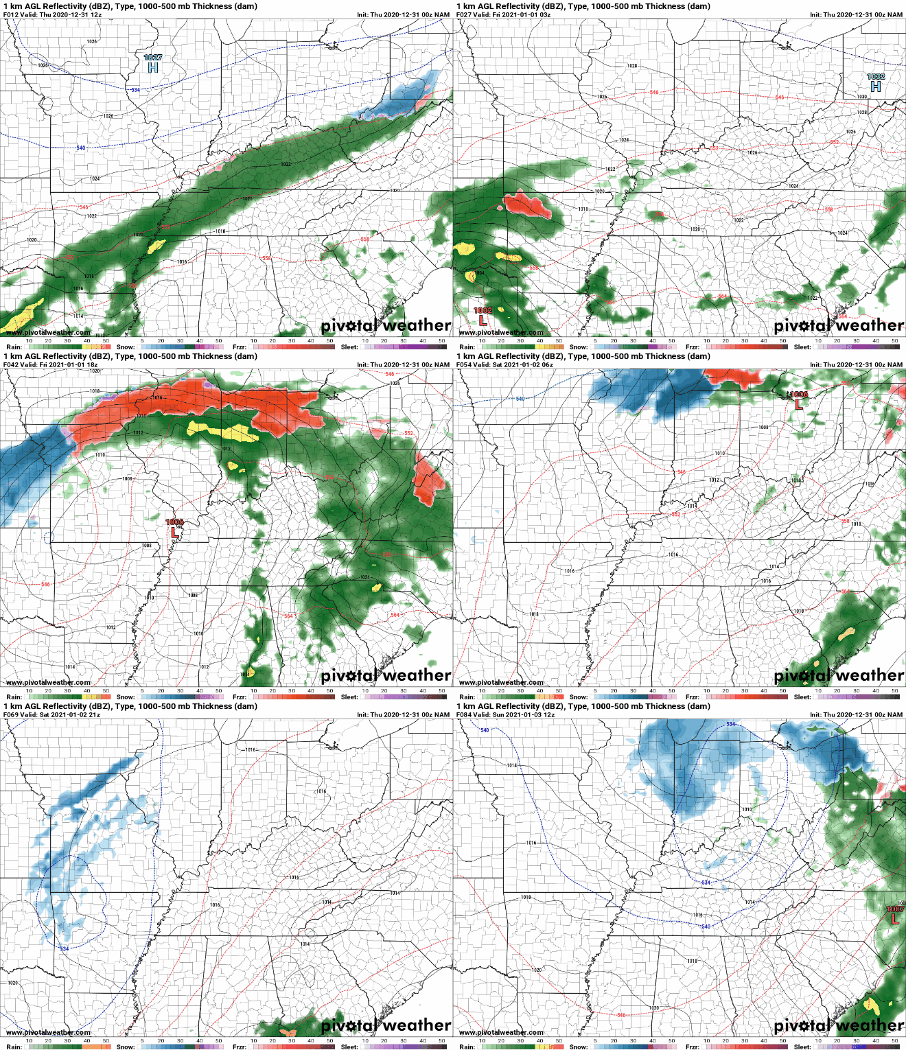
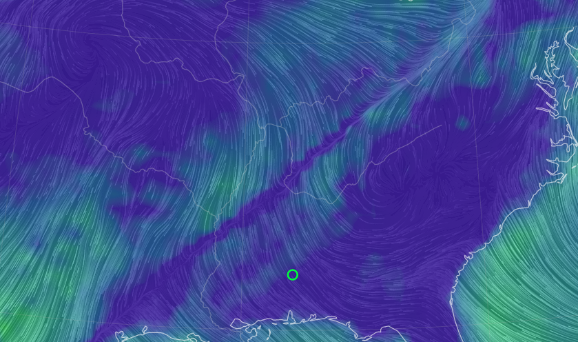
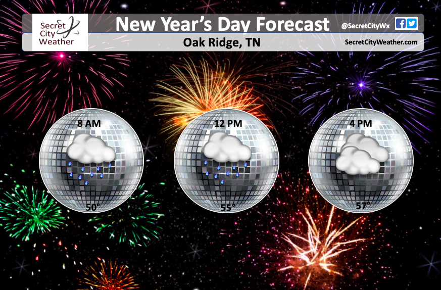
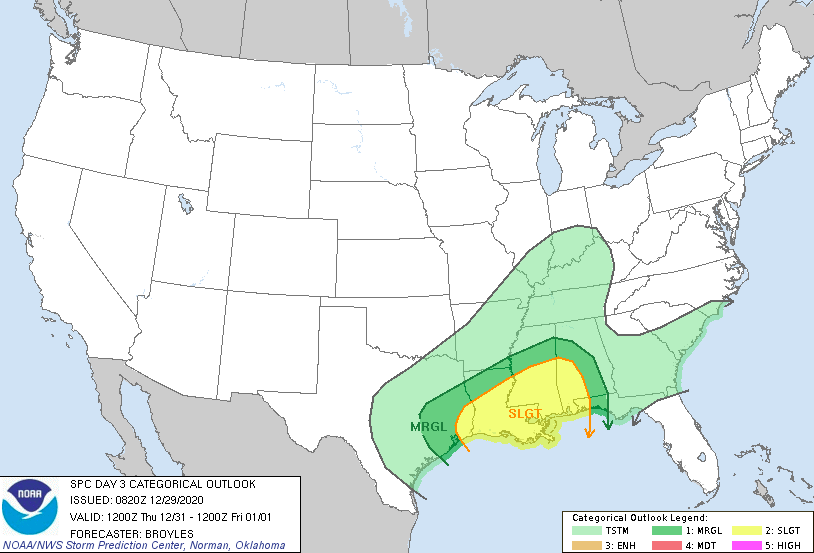
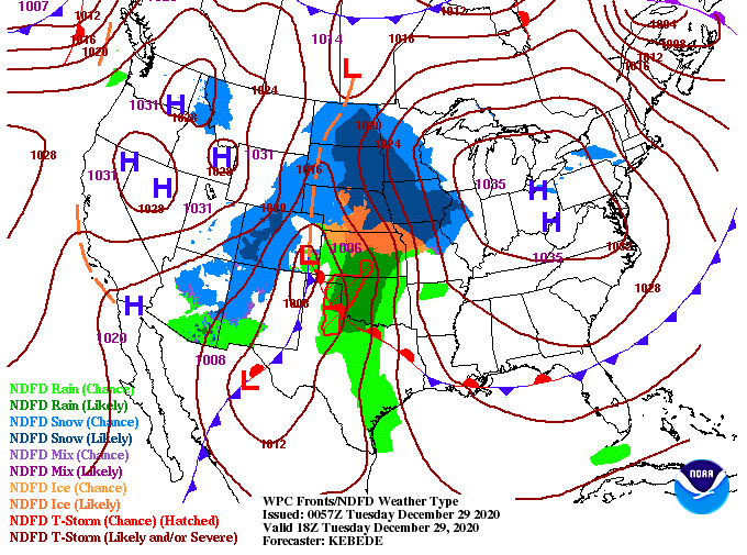
Good morning and happy New Year's Eve! Cloud clover and a few sprinkles have arrived to begin the day with more rain on the way. The good news is we are in a spot of the system where rainfall will be the least impactful. With that said, the SPC has included the far western counties of East Tennessee under a Marginal Risk for severe storms. The timing still remains best into tomorrow morning for this line bringing heavy showers and gusty winds to the region. If we transition to the streamlines map, we can clearly make out a front hanging across the region. As you can see, winds are out of the south/southeast this morning. This will continue to pump moisture and warm temperatures into the region with high's remaining in the mid 50's (today) to even low/mid 60's tomorrow. For those with plans into 2021, be sure to have some wet gear with you. Model guidance suggests upwards of half an inch total but I am thinking closer to an inch. Regardless, showers will likely be on and off through the first half of the day tomorrow before we begin to dry back out the later half of the weekend. Temperatures will be well above average tomorrow as well with high's in the 50's to 60's during the day. That will do it for today, I wish everyone a happy and wonderful New Year and we will be back on Monday (still, of course, posting on social media). Pre-recorded for 5pm show
1 Comment
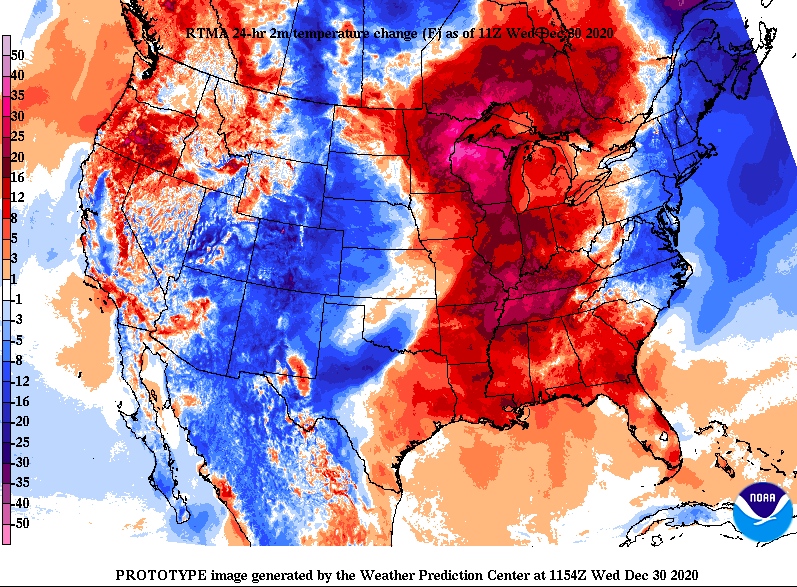
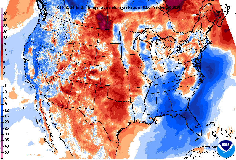
A messy hair day is in the making as strong southwest flow will lead to gusty winds throughout the day today. As you can see below, MUCH warmer air has funneled in and will continue to for Thursday. Winds will hang between 10 and 15 mph at times today with gusts of 20+ possible. High's are expected to top out in the mid 50's with high's near the 60's tomorrow. Looking at model guidance, the brunt of the system continues to stay just to the west (good news). Instead of an all day rain event we will more than likely see showers and storms in waves on and off throughout the day. A few showers/storms could be heavy at times producing isolated flash flooding, strong winds, and even an isolated tornado if the parameters set up correctly. The timing of this looks to fall in two spots, one in the afternoon/evening hours of Thursday and then again for the morning hours of New Year's Day (Friday). As of now, the SPC (Storm Prediction Center) does not have East Tennessee under any note-worthy categories but things could change this afternoon. Regardless, keep in mind a few heavier thunderstorms can't be entirely ruled out the second half of the day tomorrow and into Friday morning. We will continue to monitor our next weather maker, but for now, strap down your hats and shed the winter gear as winds will be breezy and high's will be in the mid to upper 50's. Things should stay dry through much of the day with showers not arriving until overnight. Pre-recorded for 5pm show
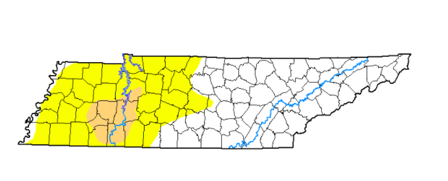
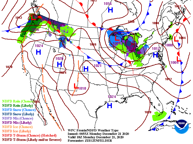
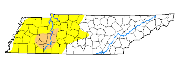
A dense fog advisory is currently in place from Knoxville down to Athens and east for low visibility issues in some areas. As we work into the day, this will expire rather quickly as sunshine will makes its return. We will see high's right on par with averages in the mid to upper 40's. As you could see on the surface map, our next weather makes sits just to the west. Though things stay dry and partly sunny today, cloud cover will migrate back in this evening and overnight. Wednesday should stay mostly dry before showers eventually work in by the evening and overnight hours. New Year's Eve is where we will find the bulk of activity on and off throughout the day. Guidance continues to suggest the track of this system running northeast but with the center staying west of East Tennessee. This means we'll see more outer shower activity in waves throughout the day and into New Year's. If you do have some outdoor plans for the "ball drop" or even into New Year's Day, be sure to bring the wet gear as shower activity will be possible through lunch time Friday. With Christmas and the winter weather we dealt with going on, we didn't get the chance to touch on drought from this past week. As you can see below, conditions remain the same from mid-December. If the track of our next weather maker stays in line with model guidance, we could see some changes (for the good) to this map later in the week. Some areas could see several inches of rain into Western TN. That will wrap it up for today but if you'd like to be apart of this year's Secret City Weather Almanac you can find information at SecretCityWeather.com/Sponsors. Pre-recorded for 5pm show
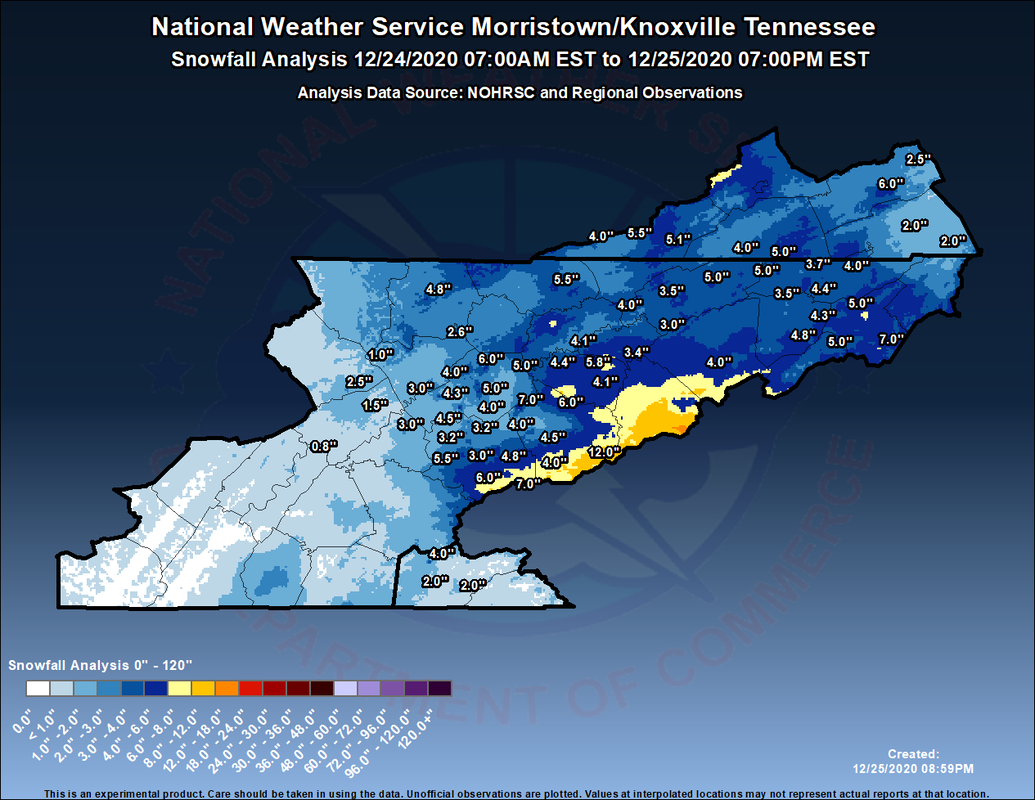
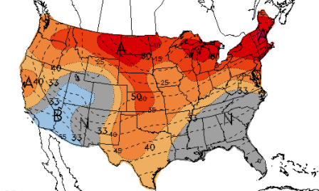
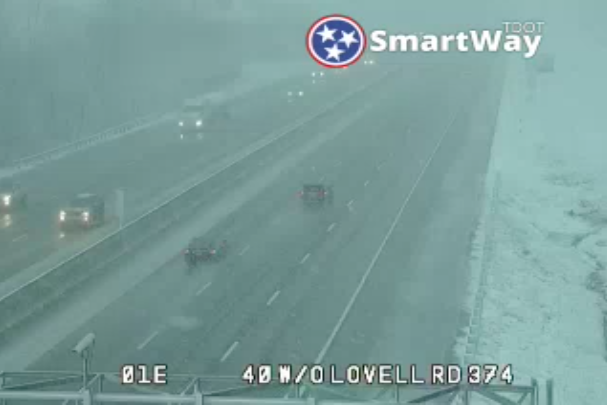
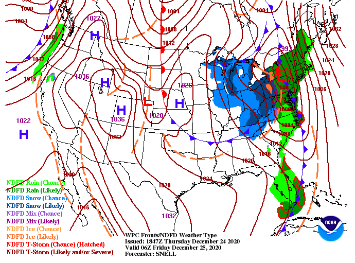
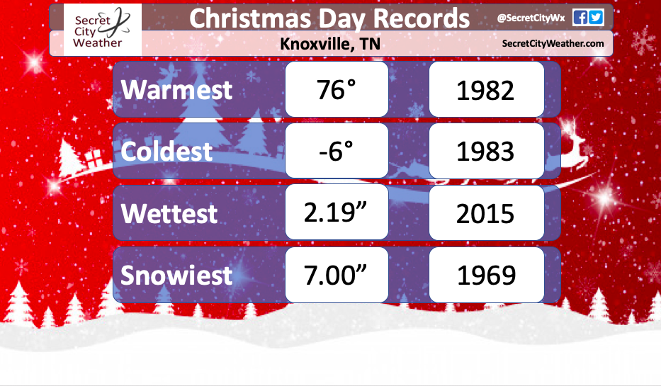
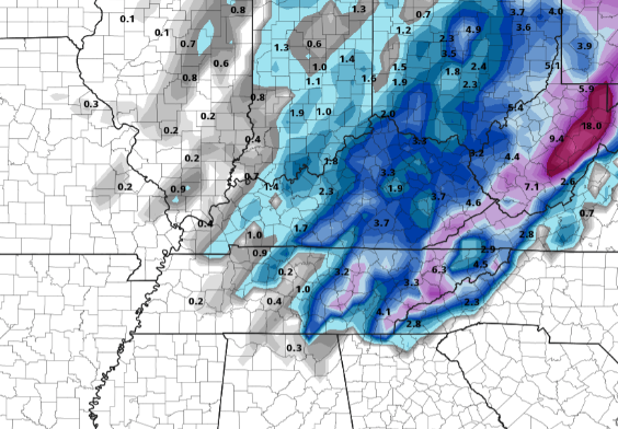
Happy Monday to you! I hope you had a good Christmas and weekend. That rare occurrence of a white Christmas did happen for many of us with the official snow totals from the NWS released below. As we anticipated, snow totals increased eastward with Knoxville picking up around 3 inches versus Oak Ridge around 0.8". Shaded roadways still have some snow laying on the ground, but with high's around 50 today, that should help continue the melting process. As we work ahead, cloud cover decreases overnight giving way to the chance for some patchy fog Tuesday morning. Through the day tomorrow, temperatures stay near average (mid to upper 40's) with partly cloudy skies. By Wednesday, cloud cover returns as a system from the west draws near. Scattered showers arrive Wednesday night with rain likely throughout the day Thursday. As of now, most of the rain should be out by the "Ball Drop" at midnight but it will depend on where you are. This system will move west to east so counties east will be dealing with this line later into the night. We will give more details on the exact timeframe as we work closer to Thursday. As we push into 2021, the CPC suggests temperatures to remain right around average to above average for this time of the year. As you can see, a majority of the United States will likely be above average as we enter the first week of the new year. That wraps it up for today, if you would like to be apart of the year's Almanac, visit SecretCityWeather.com/sponsors for a spot in this year's release. "Let it snow, let it snow, let it snow" I hope you are enjoying your Christmas Eve so far. As you can tell, the Arctic front has arrived bringing snow to the region. This screenshot is from Lovell Road in Knoxville showing a nice line of snow showers falling. For those on the road ways, especially tonight, be extremely weary of road conditions. Due to the rapidly dropping temperatures we have had, icy conditions are likely overnight and into Christmas Day. Low's tonight will plummet into the mid to upper teens with little of a warm up Christmas Day. In fact, high's will only find themselves into the mid 20's for much of the day. Winds will also play a factor in temperatures with feel-like temperatures in the teens. For areas highlighted in the High Wind Warning (East TN Smokies & SW Virginia) I would not be surprised to see feel-like temperatures as low as the 0 degrees. Prepare for a cold Christmas day regardless of where you are. The timing was perfect with this system because high pressure will move back in warming things up rather quickly Friday and this weekend. As you can see below, high pressure sits to the west and will bring sunshine back in for the day tomorrow. This will likely help with snow melt through the day tomorrow (even with high's just below freezing). A few snow flurries with be around on and off tomorrow, otherwise things stay mostly clear and sunny. Working forward, sunshine looks to stick around through the weekend with high's returning to the 50's. To finish, here's a look at your Christmas Day records. Though we'll be cold tomorrow, Knoxville won't be breaking any new records. A Christmas Day forecast can be seen on our Twitter & Facebook. (Hint cold, sunny, & a few snow flurries possible)
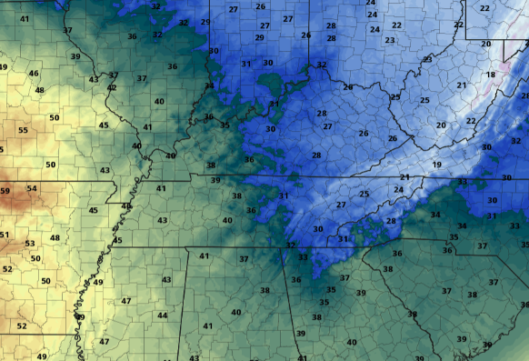
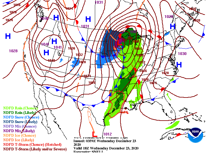
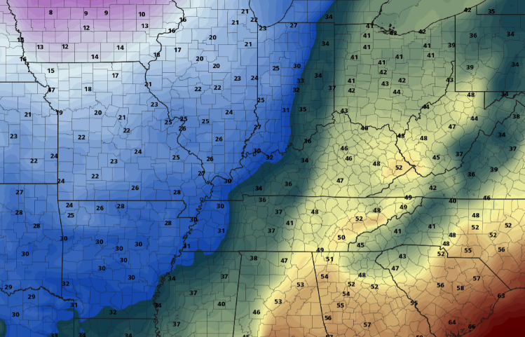
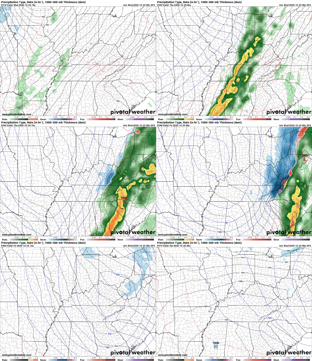
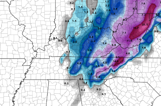
That will wrap it up on this Christmas Eve but I wish everyone a safe, warm, and MERRY Christmas! What's on the plate today weather-wise? Well, we begin this morning with some cloud cover moving in from the west. This is all associated with our next powerful system that looks to bring precipitation in many forms. As for today, cloud cover will continue to increase before showers arrive overnight. A look at Thursday afternoon (Christmas Eve), an Arctic cold front will hammer its way in from the west. This cold air mass will just be riding the back edge of the precipitation shield giving chance to some snow showers (touch more on that below). I just wanted to give you an idea of how cold things could get in such a short amount of time. Looking in Knoxville Thursday morning, temperatures will be around the 50 mark while Nashville will be in the upper 30's and 20's for far western Tennessee. Jumping into our next storm system, I will do my best to break this down. First, anticipate isolated to scattered showers this evening with heavier rainfall following into tomorrow (mid) morning. We aren't anticipating wide spread flooding by any means, but flood prone areas could see some water build-up. Showers into Thursday will be moderate to heavy with 3/4" to an inch of rain likely. Going further into detail, for the all important snow forecast, it still remains complicated. Later models, along with short term high resolution models, are trending toward a slower cold front arrival time (bad news for snow lovers). With that said, we are still nearly a day and a half out with this system currently sitting in South Dakota (as of writing this post). Model guidance does a fairly poor job of depicting these transition zones, especially with the topography we have across the region and origin of this system. With all of that said, changes still remain likely and we will continue to update you along the way. The graphic below depicts the more confident output we have moving into Christmas morning. The Central Valley and north will likely pick up anywhere between a dusting to 2 inches (likely amounts looking from the southern tip of the valley and northward). For those closer to the Smokies, 1-3" seems more reasonable with higher amounts as you work up in elevation. As is almost always the case, we will see this horseshoe shape due to topography differences. I would also like to mention some chatter from the NWS of a possible Winter Weather Advisory for the Central Valley and Plateau, so we'll let you know if they issue that as well. The NWS has issued a high wind warning for the Smokies tonight and tomorrow as strong winds are likely across the area. This will only add to the cold temperatures the second half of the day tomorrow and early into Christmas. Feel like temperatures in the single digits would not surprise me overnight Thursday. They have also put in place a winter storm watch for Thursday afternoon into Christmas morning for the Smokies and into southwest Virginia. I will continue to emphasize the dynamics associated with this system are tricky. We will monitor this throughout the day and of course overnight with a better idea of what to expect moving forward. For now, anticipate moderate to heavy rains at times tomorrow morning before a transition to snow takes place. How much snow will depend on the timing of the front. We'll be active on social media tonight, so be sure to check us out: @SecretCityWx (Twitter & Facebook). We also have some more details on your Christmas Day forecast in our daily video below. Pre-recorded for 5pm show
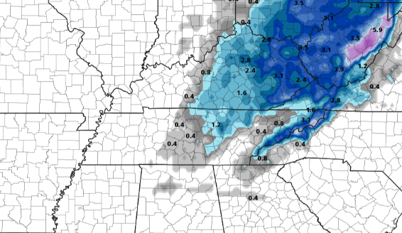
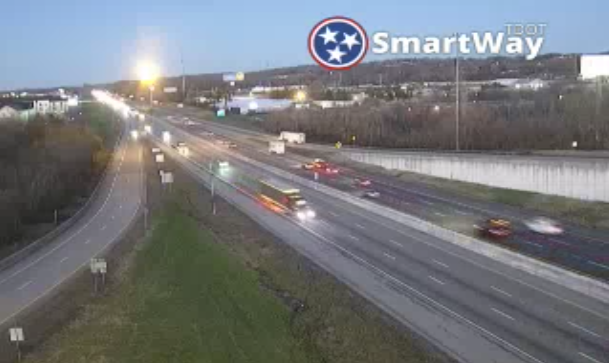
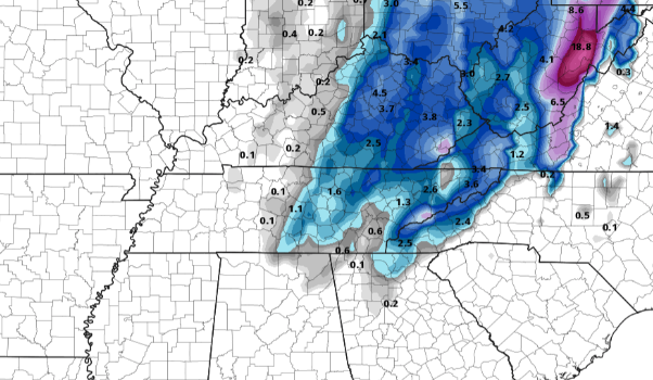
Good morning! This view comes courtesy of TDOT on Lovell Road in Knoxville. Clear skies will begin the day and continue throughout as high pressure sits overhead. With the system to our north yesterday, a cold front did pass through the area. This will keep temperatures at bay today (lower 50's) before return flow warms things up for Hump Day (tomorrow). Short-term data is beginning to feed in along with a narrowing consensus as it relates to the wintry precipitation expected Christmas Eve. First, the dynamics with this next storm system are impressive. Rain will begin the event Wednesday night bringing moderate to heavy rainfall at times and gusty winds. Areas that are very flood prone could see minor flooding, so be careful. As we work into Thursday, a cold front will power its way through bringing a transition to snowfall in the afternoon and evening. There are still some questions on how quick this cold front will move through. A quicker arrival will allow for more snowfall, while a slower arrival leaves less potential. As data (especially short term higher resolution data) comes in, we will have a better picture/grasp on the arrival time of the cold air mass. For now, here is a look at two model extremes showing higher snow totals with a quicker arrival time (right) versus a slower arrival time (left) with lesser totals. Either way, data is narrowing in on a solution. With what's in front of us right now, I do expect some accumulation across the region. The central valley and north can expect (as of now) half an inch to an inch. Further east, the foothills and into the Smokies will near the 1-3" mark with much higher totals expected on the peaks and higher elevations. Some changes are likely in store ahead, so check back in for updates along the way. A beautiful day is in the making today with temperatures remaining above average. A big change is in store the later half of the week so be sure to tune in for updates here and on social media. We will continue to provide the latest as it relates to the timing of the cold front as this will be our biggest judge on how much snowfall we see across East Tennessee. For now, pretty minor accumulations are expected but things are likely to change some over the next couple of days. Pre-recorded for 5pm show
Happy Christmas week to everyone! We are starting with a bit of fog and cloud cover overhead and temperatures in the 30's. As we work through this week, a wild weather pattern is in store. To start, things are calm and peacefully early this week with sunny skies gradually moving into today and sticking around tomorrow. "Warm temperatures" (above average) will also accompany with high's in the 50's today and tomorrow. As we push into the mid-week timeframe (Wednesday) an Arctic front will begin its south and eastward trajectory. As the name implies, COLD air will surge in Christmas Eve. We will start in the form of rain overnight Wednesday and into Thursday before the transition to snow showers on Thursday. For those who follow us on social media, you know we have have hinted and discussed this for a few days now. Given the pattern and data, that four letter word: s-n-o-w is in the forecast. What does that mean as it relates to chances, amounts, and duration? That is still up in the air as of now but guidance is continuing to focus in on a uniform solution. For now, anticipate sunshine now through early Wednesday before cloud cover arrives and eventually rainfall Wednesday night into Christmas Eve (Thursday). A transition will take place later Thursday as cold air surges in. I would like to first say this is not the forecast we are calling for, instead this is one (of several) model outputs from last night. There have been many changes over the past 3 days in regards to this system with some outputs suggesting no snow to others suggesting 10 inches. This is a big reason why weather is challenging to forecast for 6+ days out (especially winter weather). Given the data though, I am confident in rain transitioning to snow and the potential for somewhat of a White Christmas in the mix. As more data comes in and a better agreement in the models & data is reached we'll have more confidence in a forecast. Stay tuned for updates on here as well as social media as it relates to the winter weather expected Christmas Eve and into Christmas day. For now, enjoy the first day of Winter with above average temperatures and improving sky conditions. Lastly, those without plans this evening, Jupiter and Saturn will appear to merge, so be sure to catch that just after sunset in the southwest. We are starting the last day of the work week off cold with temperatures sitting in the 20's. If we compare where we were this time yesterday, temperatures are roughly 10 degrees cooler. Fortunately, high pressure settles across the region bringing warmer and drier air to East Tennessee. High's this afternoon should round out in the mid 40's under partly cloudy to sunny skies. As has been the case the past week, another line of showers will work in following the sunshine we see today. Trends continue to suggest a weakening line of broken showers for Saturday evening/overnight. With low's in the mid 30's Saturday night, anticipate some snow flakes for the higher elevations Sunday morning. By Sunday evening, clearing will begin to work back in with sunshine by Monday of next week. We also look to improve on our afternoon high's with 50's early next week. There was little to any change in the drought map for the state this week. East Tennessee remains at normal conditions while the west consists of mainly abnormally dry conditions. Taking a look at the CPC's (Climate Prediction Center) outlook, the next couple of weeks look to trend dry (not good news). Typically, December is one of our wettest months of the year (refer to our Almanac for reference). We will continue to eye potential drought conditions ahead, but I wouldn't be surprised to see worsening conditions given the current outlooks. Another round of showers to light flakes will find their way back in the second half of the day tomorrow and into Sunday before we finally clear back out and warm up. We will also be getting your Christmas forecast together through the weekend. As of now, we look to have a system bring showers to potential snow showers Christmas Eve. We'll have more on Monday...have a great weekend! Pre-recorded for 5pm show
Good Thursday morning to you! Temperatures out of the door are in the low 30's and won't improve much from that mark. A look at the National Weather Service afternoon temperature plot shows high's only getting into the upper 30's, with some locations right around the 40 mark. Look to have improving sky conditions through the day. The good news ahead is high pressure working eastward. This will allow for the slow progression of rising temperatures as well as clearer skies. As we end the work week tomorrow, high's make a return to the mid/upper 40's under partly sunny to sunny skies. However, just like with our last system, isolated shower chances move back in the following day (this case, Saturday). Model guidance picks up on the area of high pressure shifting across the region Friday bringing sunshine and dry air. By the overnight hours tomorrow, cloud cover will slide back in as a broken & weak line of showers moves through. This particular model carries a bit more moisture than will likely happen. None the less, don't rule out an isolated shower Saturday afternoon/evening before clearing back out late Sunday and early next week. We'll see high's return to the 50's by Monday of next week. That wraps it up for today...make sure to stay warm this afternoon as cloud cover early will make things feel even cooler at times. We will begin a gradual return to near average Friday before landing around 50 by Sunday. Also, if you would like to be included in this year's Secret City Weather East Tennessee Almanac, check out: SecretCityWeather.com/Sponsors Pre-recorded for 5pm show
|
Your trusted source for everything weather in East Tennessee.
Social Media
|

