|
We were spoiled last week with temperatures in the low to mid 80's and low humidity. Unfortunately, that summer time heat is back. For most of us today we will break the 90 degree mark. If you take a look below, a high pressure system (currently east of TN) has kept us high and dry the past several days. This high has shifted eastward allowing for increased temperatures and humidity to flow into our area. As depicted by the arrows, moisture and temperatures are being pulled in from the Gulf due to the clockwise flow of the high pressure system. 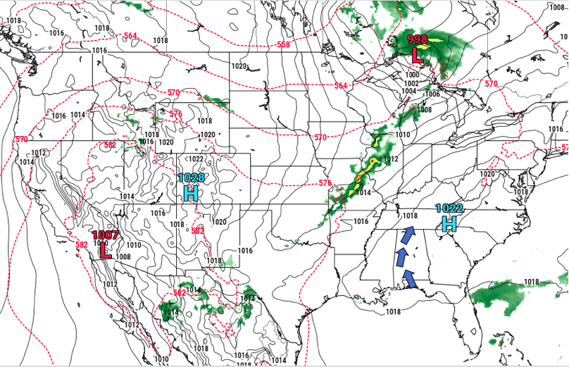 Luckily a weak cold front will pass through tomorrow afternoon providing a break from the 90's. Ahead of this front, scattered afternoon showers and storms are possible both Tuesday and Wednesday. The latest models suggest our best chance of rain for the area is Tuesday into Wednesday morning. Once this frontal boundary moves through, expect high's in the mid to upper 80's through much of the work week. Isolated to scattered showers still remain in the forecast each day this week as day time heating is the primary initiator.  Over the next 5 days (through Friday), models suggest rainfall totals between a quarter and half an inch. As I mentioned, each day will contain the possibility of your typical summer time afternoon pop up storms. Other than the chance of storms in the afternoon, we will stay mostly sunny with muggy conditions and average temperatures. 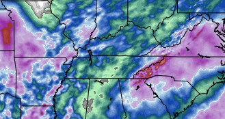 As many are planning to start the new school year this week, here is what your forecast looks like for today. Oak Ridge Schools starts today with Anderson County, Clinton and many others starting August 2nd (later this week). Thats all we have today, but I hope everyone stays cool and dry this week. 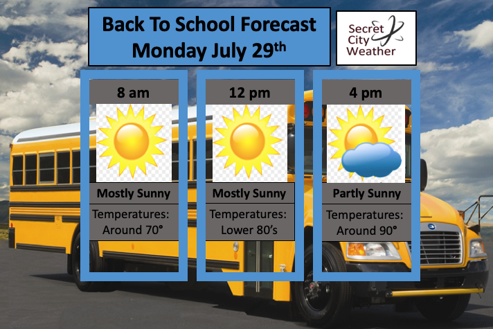
0 Comments
How about this weather in July? As I talked about in the last post, a cold front moved through allowing for the fall-like temperatures we have been experiencing the past few days. Unfortunately, these will not last long as southern flow will soon return allowing for that humidity to begin climbing back this weekend. Taking a look below, we see why we we have been so clear, and will continue to be, over the next few days. A high pressure system, currently residing in the Indiana region, is dominating much of the mid east.  To emphasize the importance of this ridge, take a look at the NAM 850mb winds run. This model is depicting winds over the next couple of days at the 850mb level. As you can see the stronger winds (shaded green and yellow) are much to our north. This will allow us to continue staying dry and sunny into the weekend. As I said though, don't anticipate this to last as southern flow will return, increasing the chance for afternoon pop up showers and storms by early next week.  As for today and tomorrow, enjoy slightly below average temperatures and lower humidity, which will make things feel rather pleasant. As we work into this weekend it will begin feeling more muggy, but we will stay mostly dry. This weekend would be the ideal weekend for the lake or pool as you can expect mostly sunny skies and average temperatures (upper 80's). Heading into Monday and early next week, shower chances increase. Until then, soak up the rays!
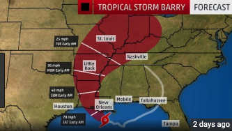
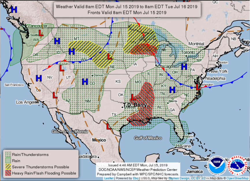
I hope everyone had a good weekend. We will have an active start to the week, but it will be well worth it. As seen below, an unusual July cold front is working its way through the Ohio and eventual, Tennessee valley's.  Ahead of this cold front will be lots of storm activity for most of Kentucky and Tennessee. This storm activity will likely be strong to even severe at times this afternoon and overnight, so continue to check back in with us on the latest. It is important to note much of east TN is under a FLASH FLOOD WATCH until 2am Tuesday. This means the preconditions for flash flooding are in place and areas under this watch are favorable for flash flooding in flood-prone areas. As I said, please have ways to check back in with local weather officials for the latest watches and warnings. Storms will likely begin popping up early this afternoon with the brunt of the system arriving by this evening. This evening and into the overnight hours, expect gusty winds, lightning, small hail, and heavy downpours at times.  As we work into our Tuesday, showers will begin to dwindle by the morning hours, eventually fading by the afternoon. Once showers move out, expect beautiful clear skies and cooler temperatures. If there are any outdoor plans you have been delaying due to heat or rain, this is the perfect week to do them. Tuesday afternoon, Wednesday, and Thursday will be fall-like with high's in the low to mid 80's, low humidity, and sunny skies. Soak it all in though, as the heat and humidity will soon return later this weekend and into early next week. As an example to show what you can expect temperature wise this week, check out this modeled temperature run below. As you can see, we will remain in the low to mid 80's for the next several days. I hope everyone has a good week filled with lots of outdoor adventures (which we would love to view and share here -- simply email or tag us on social media).  I hope many of you are staying cool and dry this afternoon as heat indices are beginning to near the triple digit mark. Scattered storms are currently across much of east TN now, but these will begin thinning out as we get closer to sunset. Looking ahead, brace for that mid July/early August heat. High's are not too much above average, but relative humidity will make temperatures feel in the lower 100's this weekend. As seen below, this heat outbreak isn't localized to just east TN, with 2/3 of the nation feeling the heat this weekend too.  On the bright side, cooler temperatures are on their way. First, lets talk about rain potential to end the week and into the weekend. With remnant activity still sticking around from Barry, day time heating and precipitable water values still pretty high, afternoon showers are likely to pop up across the area. This will be the case Friday and Saturday. Sunday and Monday a new round of showers will arrive bringing locally heavy rainfall, storms, and strong winds.  Following this moderate system Monday, we will see much cooler temperatures follow. If you take a look at the run below, you can see the line of cooler temperatures migrate from the northwest to the southeast as the GIF continues through. This will allow us a break from the heat with high's next week expected to be in the low to mid 80's. The strong ridge that has been sitting over the area will begin breaking down and moving out.  NOAA is in full agreement as their latest graphic shows below average temperatures for much of the eastern United States next week. Enjoy your Friday and have a good weekend. Stay dry toward the later part of the weekend and into next week and remember to stay hydrated as "feel-like" temperatures will likely be in the lower 100's. 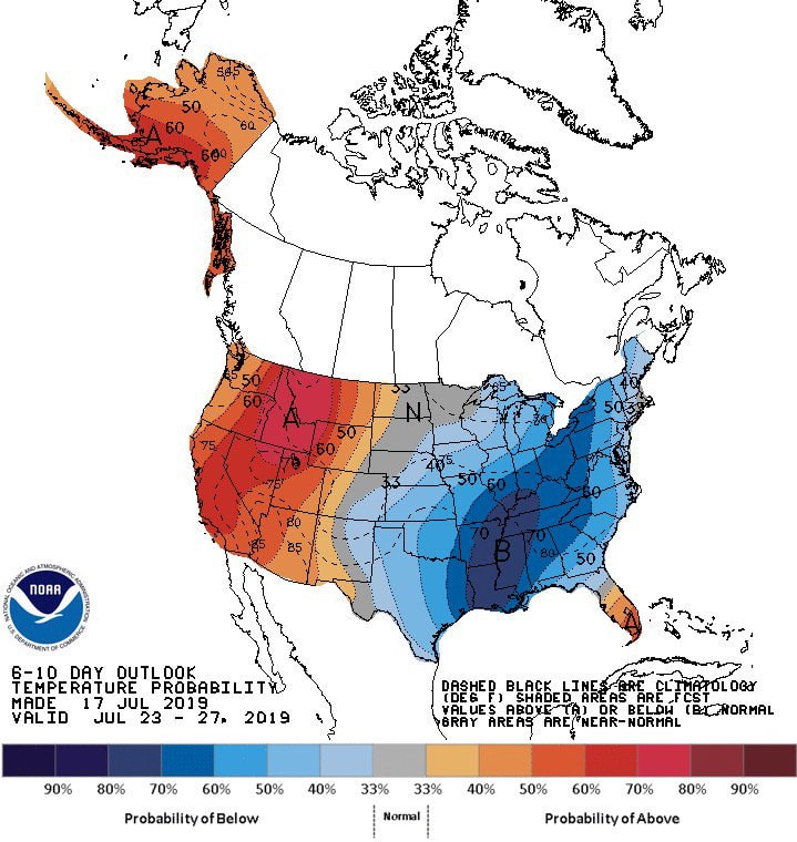 Happy July 15th and Monday to everyone! A little update on my self: I had surgery Wednesday afternoon on my jaw, but I am recovering and feeling better each day. Thank you for bearing with us here and on social media the past few days. I plan to get back on schedule today with everything. So onto the weather.... It has been a big topic in the weather and news world since late last week, Barry. As of right now, "Barry" is predicted to take a more westwardly path than previous anticipated. I will explain the reasons why and how that will effect us more below, but because of this new "path", you can expect less precipitation than anticipated. Last week I was calling between 1-4 inches of rain through Thursday of this week, but with more westwardly movement, I am calling for rain totals up to an inch and a half. This is open for interpretation because our western counties will receive more rainfall than our far eastern counties. Nonetheless, up to 1.5 inches of total rainfall through Thursday is a good average for the eastern portion of the state. This weekend we will see residual rain bands move through the area associated with this trough. Being a full 6 days out, it is hard to pinpoint how much addition rainfall we could see this weekend, so up to half an inch is a safe bet for now. 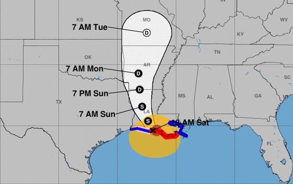 As I briefly touched on above, the path of former hurricane Barry has moved more westward. The reason? Due to an upper atmospheric pattern currently residing over the United States. Taking a look at the current forecasting map (bottom right) you can see a "L" (representing a low) between two "H's" (representing high's). This low has become engulfed between these high pressure systems and has funneled more westwardly. Think of a high pressure system as a wall of traffic and the "low" as a car trying to drive in this traffic jam. In this case, the "space" is more westward in between the high's, which is what is taking place. The bottom left graphic (an older image) was shown to represent the full cycle of this low. I am sure many of you remember the shortwaves and afternoon popup storms we received early last week, well that was part of what morphed into hurricane Barry. Barry will eventually do a complete 360 degree turn by this week. The proposed track of the low can be seen above, but the entire cycle and path that it took over the course of a week and a half can be seen in that bottom left image.
Looking ahead to the likely path of this low, we see (based on this model) for it to move north and east of our area by the end of this week. The model below is showing the 850mb level winds. We see at the beginning of the gif a "circle" with bright red colors to the east of it (strong winds). As the gif continues, this begins to weaken, move north and east, and eventually converge with another low in Canada. 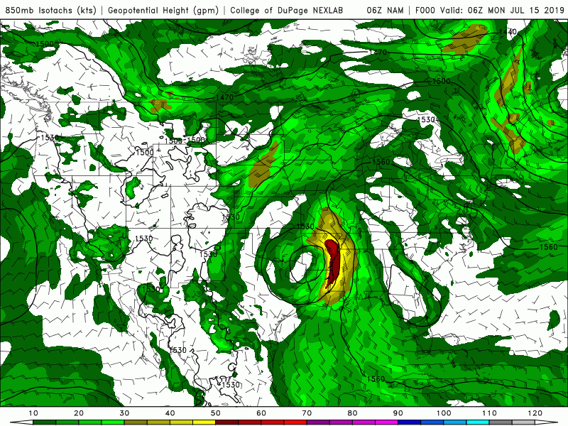 Moving forward into mid week (Wednesday) expect those rains chances to increase as the rain associated with this low grows closer. Barry, now known as a shortwave trough will propagate (move) north and east of Tennessee later this week and eventually out of the area by late this weekend. As I said, our highest day for precipitation will be Wednesday and the first half of the day Thursday before scattered showers finish our week. This weekend we could still see scattered showers from this propagating low, but they will be your "typical" afternoon scattered storms that we have been used to lately. Temperatures will be average, with the exception of tomorrow (Tuesday). As southern flow begins to dominate, temperatures will be cranked up into the low 90's and heat indices could feel closer to the mid/upper 90's by the afternoon. 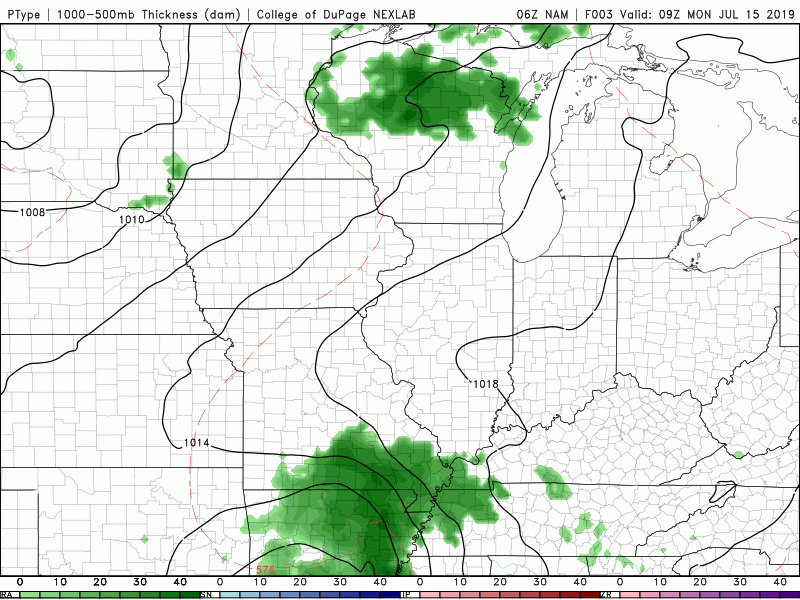 Below is the 3-day outlook describing what I said above. Mostly cloudy with a few isolated showers/storms today and tomorrow with the brunt of rain coming Wednesday and Thursday. I hope everyone has a good week and don't forget the umbrellas mid week! 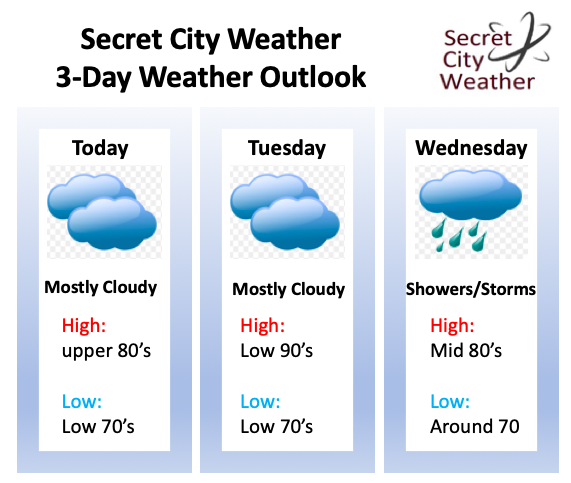 Good afternoon and happy Monday! It has been a quiet day weather-wise thus far, with only a round of spotty showers that moved through the Oak Ridge area earlier this afternoon and a few near the Dayton, TN area. Transitioning into this evening and the overnight hours, we will remain pretty quiet with only an isolated shower/storm possible in the higher elevations.  As we look ahead to the next few days we will continue this summer time pattern with warm highs, high humidity, and mostly sunny skies. As the NAM (below) emphasizes, we will remain mostly dry over the next few days with only an isolated shower or storm popping up in the afternoon hours. Most of these will form in the higher elevations, but a few could carry over to parts of the valley. All in all, it feels like day 50 of this weather and it won't be changing anytime soon. 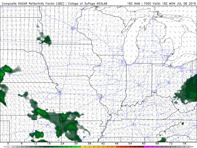 Something cool to our south some may be interested in, is the development of some tropical weather. The Atlantic has been very quite so far this year with no tropical storms or hurricanes, so this system could be very interesting. This is especially so because it will likely impact the Gulf states: Texas, Alabama, Mississippi, Louisiana, and Florida later this week. A cyclone will push south due to ridging currently over the eastern United States and enter warm, moisture rich Gulf waters. As time gets closer forecasters will have a better idea on the strength, impacts, and path of this system. For now, many models show this system pushing more westward into parts of Texas, Louisiana, and Mississippi. 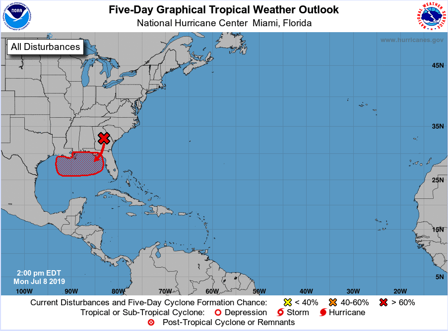 Here is your three day planner (below). We will remain mostly sunny and humid over the next couple of days. We could see a spotty shower or two make their its way into the valley, but most (if any) activity will stay in the Plateau and the Smokies. I hope everyone stays cool and has a good rest of the work week! 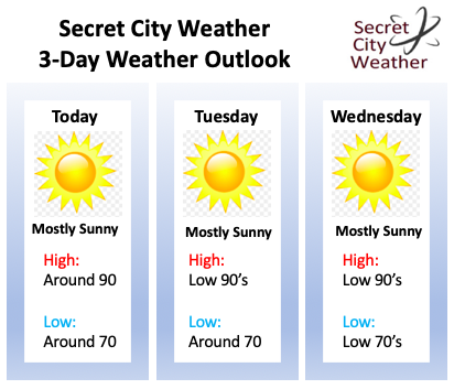 SIDE NOTE: I will be having surgery Wednesday afternoon, so please bare with me on social media and here. I will try to get out the usual Thursday (on the website here) post on time, but if I do not, know I will as soon as I can.
Happy Fourth of July to everyone! I am sure many of you can predict, but the weather remains much of the same today. Hot and humid with isolated storms possible in the afternoon hours. Taking a glance at the overall weather pattern below, we see a ridge (high pressure system) still in place over the southeast. This will begin to work its way eastward this afternoon, allowing for southern flow to return tomorrow and Saturday. As this ridge begins to weaken, shower potential will increase. 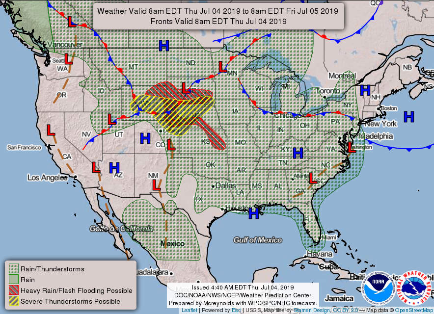 Taking a look at the latest HRRR model run, we see those isolated storms popping up this afternoon. Lately, the HRRR runs have been over predicting the formation of these storms across east TN. As day time heating is the main driver of these storms, it is very challenging for models to pick up on when and where they may form. Nonetheless, you can expect much of the same as yesterday. Isolated to scattered storms are likely to begin popping up early this afternoon and carry on to the early evening. For you firework lovers, the sun will be setting around the 9 o'clock hour this evening. Based on the latest data, I would not rule out a residual storm or two. As the night grows, the storms will begin to "fizzle out" due to cooling temperatures. Many of these storms will form in the Plateau and move eastward through the afternoon. As the sun is setting, expect most of these cell's to be in the higher elevations or to the southern portion of the state. This will allow for a nice night to enjoy many of the firework shows planned around the east Tennessee area.  Below is your day outlook across east TN. I released this graphic this morning for those following along on social media, but I will place it below as a reminder for the day. I know many cities around the area (Knoxville, Kingston, Oak Ridge, etc.) are planning a firework show, so go out and enjoy it! For most of the area by that time I expect it to be partly cloudy and dry. As I said, if there are any storms, they are likely to be to the south of the valley or to the east (in the higher elevations). 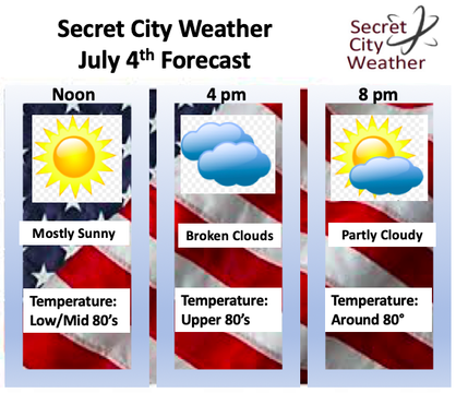 Looking ahead into Friday and the weekend, shower chances will increase slightly. As the ridge begins to break down and weak shortwaves move through, expect storms on and off through Friday afternoon, and the highest precipitable day on Saturday. Sunday and early next week we will return to what we have been dealing with recently (hot, humid, isolated afternoon storms).  Taking a look ahead, the Climate Prediction Center thinks we will remain average (both temperature wise and precipitation wise) through the next week or so. I tend to agree, as temperatures will likely stay in the upper 80's and low 90's for much of next week. I also believe the "summer-time" flow we have been dealing with will persist, allowing for our average rainfall across the region. As always thank you for viewing our content and staying up to date here. I hope everyone has a magnificent Independence Day and weekend. 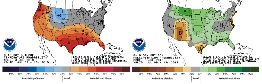 I hope many of you have stayed cool and hydrated through the weekend, as it has been a warm one. Unfortunately, the heat will not be letting up anytime soon. First looking at the forecasting map produced by the NWS, we see a dominating high pressure system in the southeast. This has stuck around for several days resulting in the clear skies and warm temperatures we have had. As I said, this will continue most of the week, as high's are expected to stay in the low 90's through Independence Day. Along with the warm temperatures, expect high humidity. This will make afternoon high's feel closer to the triple digit mark today and mid to upper 90's Tuesday. 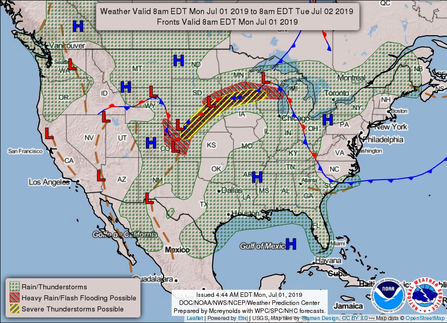 Afternoon pop up storms still remain something to be cautious of throughout the first part of the week. With a nice layer of moisture present and afternoon temperatures climbing into the 90's, pop up storms induced by topography are possible. Storms that do develop will generally stay outside of the valley in the higher elevations, but don't be alarmed if an isolated storm or two does pop up in the afternoon and early evening hours.  The latest NAM model run indicates much of the same cloud (or lack of) conditions over the next few days. As anticipated, the high pressure system will keep most of the region high and dry, meaning mostly sunny skies. During the overnight hours we could see clouds develop as nocturnal temperatures near the dew point indices. Fog is possible in the early morning hours, so be cautious on your way to work. Toward the end of the work week, we could see some increased shower potential due to rounds of embedded shortwaves. This will allow for slightly cooler temperatures (in the upper 80's) by Friday and the weekend, but I will have a better idea on precipitation chances and temperatures in the coming days. Until then, stay cool and hydrated and I hope everyone has a great week!  Below is your 3-day weather outlook across the region. As I said, hot with temperatures in the low 90's, feeling like the mid to upper 90's, and isolated pop up storms possible in the afternoon hours. For your full forecast, check out the "Weekly Forecast" tab at the top of our site.  |