|
Good afternoon and what a soggy one it has been so far. Our station (in Oak Ridge) has picked up just shy of half an inch so far today with much more in the forecast this weekend. The latest radar scan can be seen below. Scattered showers will continue on and off through the day and into tonight. 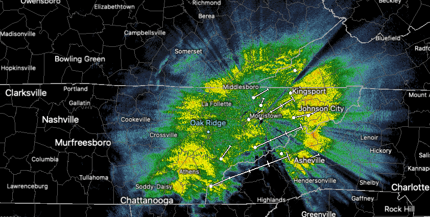 Timestamp: 1:20 pm As waves of moisture work in this weekend, flash flooding is a big concern. Two major rounds of rain break down as follows: Round 1: now through the first half of Saturday, moisture will bring moderate to heavy showers periodically. There will be breaks from the rain at times, but they likely won't last long. By tomorrow afternoon, we take a brief break from showers before round 2 arrives. Round 2: This is the big flash flooding risk of concern. As with the rain we are currently seeing, a similar track is planned with our next low. Working in a northeast direction, a warm front will lift bringing heavy rainfall to East Tennessee late Saturday and through Sunday. This will be followed by tail-end moisture associated with the low's cold front into Monday. The combination and intensity of rain (at times) will likely lead to rising waters and flash flooding across the region.  The Weather Prediction Center (WPC) has placed East Tennessee under a slight risk (10-20%) for Flash Flooding Sunday into Monday (more on our video below). This graphic below, also released by the WPC, indicates rainfall totals between the 3-5 inch mark with locally higher amounts nearing 6+ inches. This graphic is valid now through Monday night. 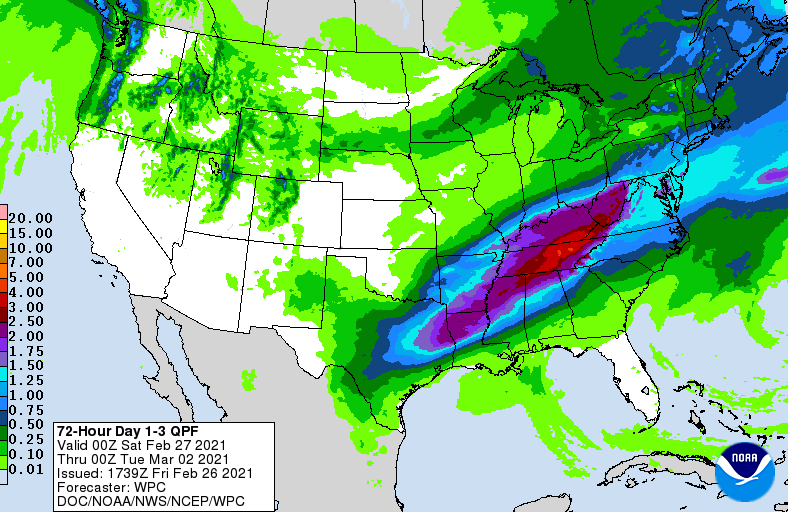 With flooding an increasing concern (especially the later part of the weekend), take the proper precautions now. Have a way to receive alerts for the latest watches, warnings, road conditions, etc. Remember to never drive through flooded roadways as they can quickly carry away your vehicle. This is in addition to the fact that water depth, movement/speed, and road conditions (or lack of) underneath are all unknowns. 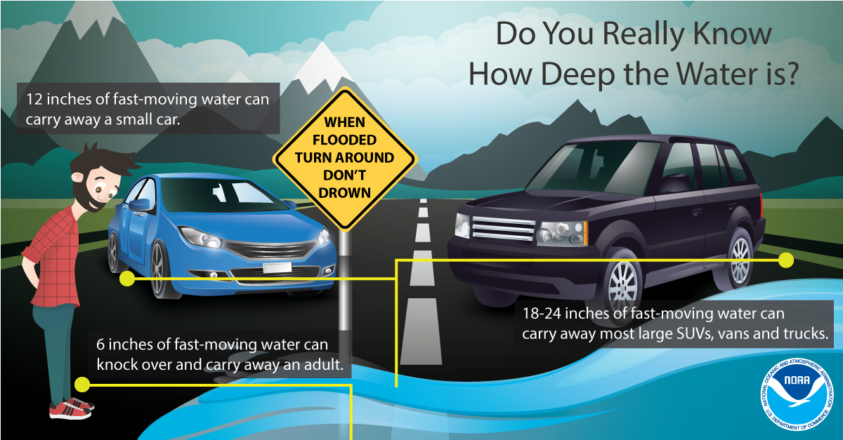 Remain alert this weekend, especially if you are in a flood prone area, near water bodies, or in low-lying areas. We will continue to monitor the track and give you the latest updates as they come in. For reports email [email protected] or tag us on our social media handles. Stay safe, stay smart, and do your best to stay dry. Pre-recorded for 5pm show
0 Comments
Any rain we had this morning has shifted east and out of the area. Cloud cover has worked out as well but will quickly moving back in tonight. Several waves of rain will push through the Mid-Atlantic this weekend and early next week bringing the chance for heavy rains and flooding. The graphic below is of integrated water vapor transport. This is essentially where the water vapor (for rain) will be derived from and by how much. As you can see, dark shades of red indicate heavier water vapor (AKA heavier precipitation amounts) across Tennessee and Kentucky. The Gulf of Mexico will be a direct pipeline for the moisture we see ahead. 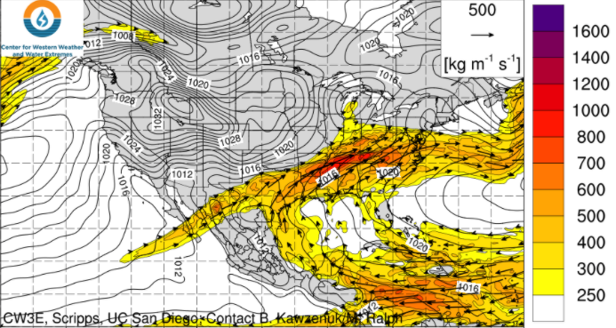 Trends continue to stay on par with a soaker through the weekend. A low will carry a warm front north providing moderate to heavy rainfall Saturday into Sunday. As the low works north and east, a trailing cold front will bring additional moisture Sunday into Monday. Rain will begin working out with scattered showers not out of the question through midweek.  The Weather Prediction Center has rainfall totals through Monday night in the ballpark of 4-7 inches. This will be a significant amount of rainfall over a 4 day period, so anticipate water build up. The axes of heavy precipitation is still in question so continue checking back in for updates. As of now, 4-7 inches is possible for north central and northeastern Tennessee. The one positive is the abnormally dry conditions much of the state has been dealing with the past several weeks. This could help combat heavy rainfall early, but water build up will be likely in the end. Most locations should see upwards of 3 inches with much higher amounts likely depending on where the higher moisture plume ends up. 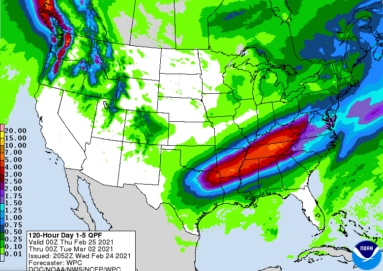 Continue to stay up to date here and on Twitter/Facebook as we'll provide a better idea on rainfall amounts, impact, and timing Thursday and Friday. Enjoy the day as high's remain above average (around 60) but will be cooler than what we saw Wednesday. Pre-recorded for 5pm show
Good Wednesday morning to you! We have a mild start so far with very "warm" temperatures planned for this afternoon. Taking a look below, high's will range from the upper 60's to low 70's with some locations likely to reach the mid 70's. As a cold front works in the later part of the day, we could see breezy conditions in the afternoon. Cloud cover will be on the increase ahead of this weak system as well. 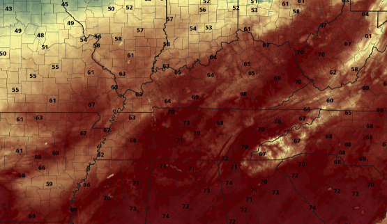 As we progress ahead, there's lots to discuss. First, as mentioned above, a system (mainly to the north) will work through tonight bringing light rain to the region before departing early Thursday. We'll dry back out Thursday before another wave brings rain Friday. We discussed this briefly yesterday but this system has shifted further east in some models. Uncertainty still lies within the data but if this does shift a bit further east as the GFS suggests, less rainfall is in the forecast Friday to Saturday. If this turns out to stay its course from earlier guidance, this could be our primer to an extremely wet weekend -> more below......  It seems like every year (specifically in February) we deal with a flooding event. This year seems to be on par with the trend as yet another set-up looks favorable for heavy rainfall and flooding potential. Round 1: Like we suggested above, our system's track Friday will be a big key in rainfall for this weekend. For starters, a more westward favored track could bring us anywhere between 0.5 and 1.25 inches of rain. On the opposite side of the spectrum, scattered showers could bring a few tenths with upwards of a half inch. This doesn't seem like too much of a difference but much more is on the way. Round 2: Following this batch Friday into Saturday, another wave derived from the southwest will work north and east Sunday through early next week. This could be the knock out blow as a warm front lifts north bringing moderate to heavy rainfall Sunday and Monday. This will then be followed by showers ahead of a cold front Monday into parts of Tuesday. This will be highly dependent on the track of the system and where the axes of heavy moisture ends up. We are still many days out and changes are likely. For now, the graphic below gives you a rough idea on how much rainfall we could see over a 4 day period. Flooding is a big concern working into this weekend and early next week, so check in for updates in the days to come. 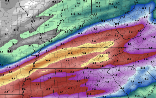 Enjoy another Spring-like day today with temperatures a bit cooler tomorrow. Rain should be out by the morning Thursday with partly cloudy skies to fill in by the early afternoon. Working towards the weekend, tune back in as a flooding scenario is could be on our radar. We'll keep you well updated with the latest. Pre-recorded for 5pm show
Knoxville typically averages high's (in late February) in the lower 50's and we are expected to top out in the mid 60's (potentially low 70's tomorrow). High pressure from the south has built in leaving us in the wake of some gorgeous Spring-like weather. This trend should continue into Wednesday as well before a brief chance for showers arrive overnight and into Thursday.  Looking at forecasted temperatures for Wednesday, high's will range from the mid to upper 60's in the afternoon. Depending on the arrival time of our next "quick hitter" we could see high's in the lower 70's before the day is said and done. Regardless, go out and enjoy this beautiful weather while it is here. 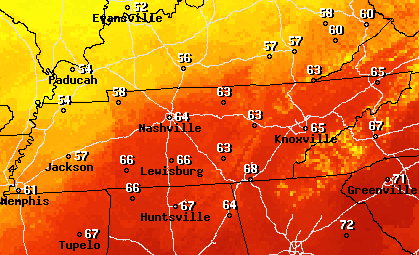 Looking ahead, changes are again in the forecast. An uptick in unsettled weather is expected to find us to end the work week and push into the weekend. There is still quite a bit of uncertainty with this next system but rain is likely in the forecast. The original track (earlier this week) had this next system pushing a bit further north. A warm front will bring rainfall (heavy at times) before additional moisture ahead of a cold front. As we progress towards Friday, new data suggests a more eastward progression (limiting the heavier rain & flooding threat). We will continue to keep a close eye on the track and the impacts we could see later in the week.  Enjoy this gorgeous afternoon as we'll have an even warmer one tomorrow. Rain finds us towards the end of the week but uncertainty on impacts still remain. Have a great one and enjoy the conditions! Timestamp: 12:40 pm
Good Monday afternoon to you! Rain worked out late this morning and the clearing out process has begun. Though there was no threat for winter weather last night/ this morning, very different conditions were felt at 5,000 feet. This gorgeous view comes courtesy of the Newfound Gap camera in the Smokies. Near 2 inches of snow has fallen as of noon. 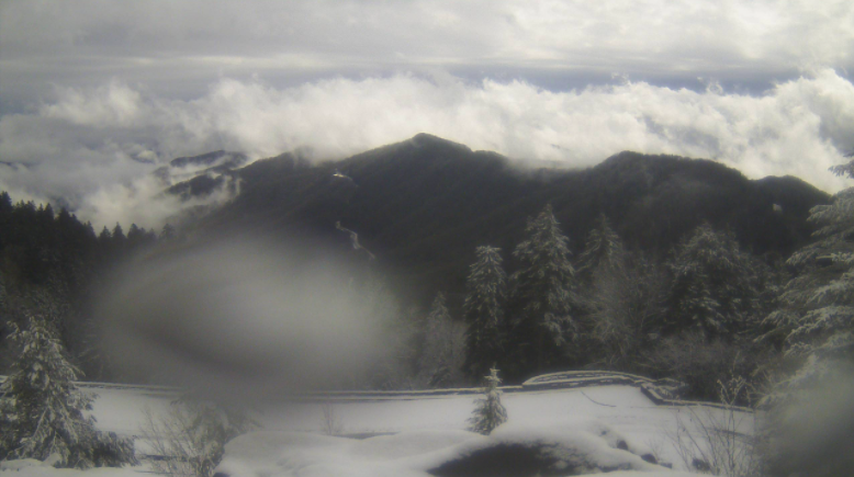 Looking ahead, we can enjoy some much needed sunshine and warm air. Temperatures will generally trend above average much of this week with most locations likely to see 60's Wednesday afternoon. Knoxville's average for this time of the year are the low 50's, so we'll take it compared to the 20's, 30's, and 40's we averaged just 7 days ago. I will note a chance for showers returning Thursday through the weekend as little disturbances work through the region.  I mentioned Wednesday being our target day for warm air, and as you can see below, temperatures will range from the upper 50's to mid 60's. Some locations to our south could even flirt with 70 by mid-day Wednesday. We may not be entirely out of the woods yet for Winter but the pattern does look promising for a warmer next few weeks, at least for now. 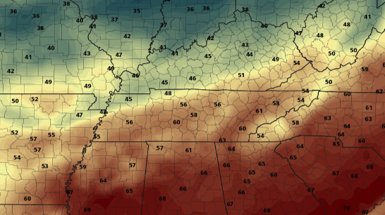 With our Almanac quickly on the way, we welcome you to be part of the addition with a sponsorship. More information can be found at SecretCityWeather.com/sponsors Pre-recorded for 5pm show
I hope you are enjoying your Friday so far, sunshine continues to build in this afternoon with temperatures currently in the mid to upper 30's. A rare sight can be viewed below with roughly 80% of the country sitting under some snow. Working ahead, a warming trend is expected with highs likely above average a majority of this next week. 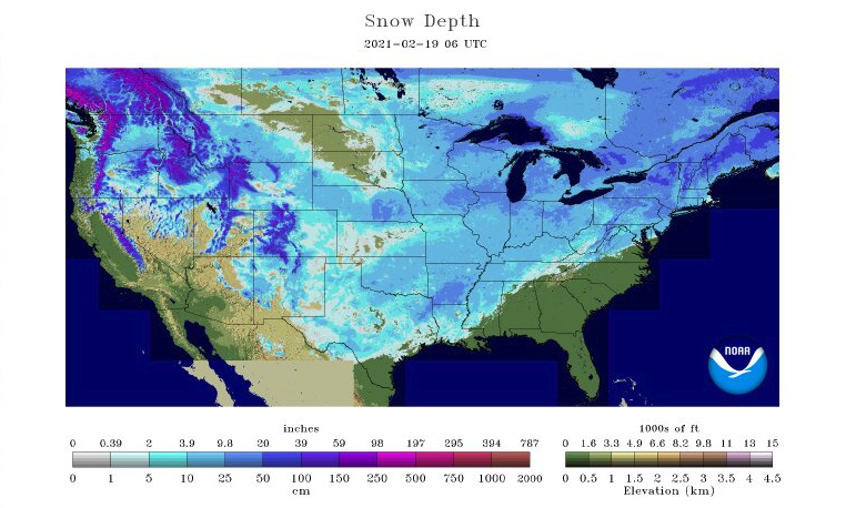 This weekend will mainly consist of sunshine and warming temperatures. A quick moving disturbance to our north will bring rain overnight Sunday and early into Monday. Early indications suggest rainfall totals near a quarter of an inch before clearing out Monday evening. Following this event, sunshine and temperatures above average are expected midweek.  A pattern shift is ahead with warmer air arriving next week. Sunshine will fill much of the weekend with Sunday being the best day ahead. Reminder, if you are interested in being apart of this years Almanac release, visit SecretCityWeather.com/Sponsors With temperatures across the valley near 40 degrees at the lunch time hour, I think it's safe to say any snow is now gone and melted. Early reports suggest 0.2-0.5 inches were picked up in isolated locations around the valley. Taking a look below, snow can be seen from the "true-color daytime" band from GOES-EAST. Because it is not animated it is hard to distinguish cloud from snow, but I promise it's there. An animated version can be found in our daily video forecast at the bottom of the blog. 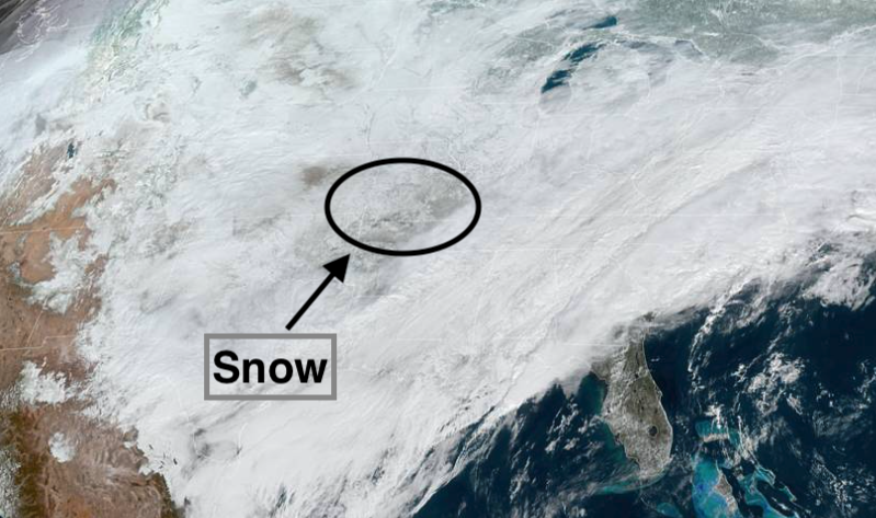 Looking at the current radar (timestamped 11:50am) another round of moisture will bring a light rain to snow across East Tennessee. This will mainly impact the Plateau and northern half of the state, but don't be surprised to see a few flakes overnight. 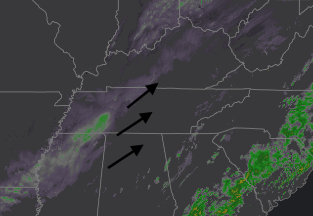 We finally have some good news ahead as temperatures rebound into the weekend and sunshine finds us back tomorrow afternoon. High pressure builds in late tonight from our west allowing for much needed clearing tomorrow afternoon. Temperatures will manage their way back to average as well with high's Sunday in the low to mid 50's. A quick disturbance looks to bring rain Sunday night into Monday but we should be drying back out by Monday evening. The pattern ahead looks to be much more average with sunshine and 50's to 60's by midweek next week.  Black ice will again be an issue for some tonight, so take it easy as we end the work week tomorrow. Much warmer and drier air is head this weekend, so enjoy it. For more details, as well as an animated satellite slide, check out your full video forecast below: Pre-recorded for 5pm show
A low pressure system currently resides in the northern Gulf Of Mexico. As moisture surges in through the day, we'll see a wide range of precipitation types through Friday morning. To start with, rain will arrive this evening/overnight before cold air makes a transition to freezing rain and snow. Specifically here in the valley, rain to a light snow is likely. As you can see below, a surge of cold air creates a nosing snow-band through the plateau and western edge of the valley. As temperatures increase Thursday, this mixed precipitation will turn to all rain throughout the day. By Thursday night, a transition back to light snowfall & flurries is likely. Following this system, anticipate warmer highs and sunshine for the weekend. 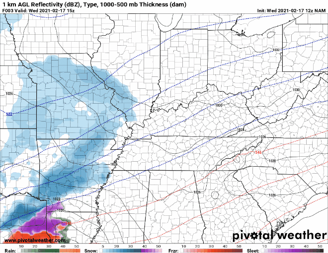 The current hazards issued by the NWS can be seen below. I have also included the details you should expect based on your highlighted county. Keep in mind topography and how that will play a roll in what precipitation you will see. For example, the western portions of Anderson, Roane, and Rhea are much higher than the eastern half of the county. This means enhanced snow totals are likely for the western side of the county. The same can be said for the eastern side of Sevier, Cocke, Greene, and Washington (with the Smokies). Generally speaking, the valley will see a dusting to 2 inches over the course of this event. Two inch totals are more likely for the northern valley, the decrease in elevation along the Winter Storm Warning, and again for the elevation incline along the Smokies. Areas shaded pink could see 2-4" with locally higher amounts up to 6" possible. 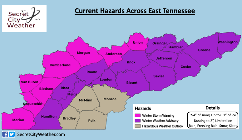 Will Knoxville generally the "heart" of East Tennessee, snow totals look grim. Ensemble data suggests a few tenths of an inch of snow at best. If you refer to the model gif at the top of the blog, areas to the right of the cold nose will see rain more than snow (unfortunately where Knoxville falls). Elevation and warmer valleys will also account for more rainfall than wintry mix. 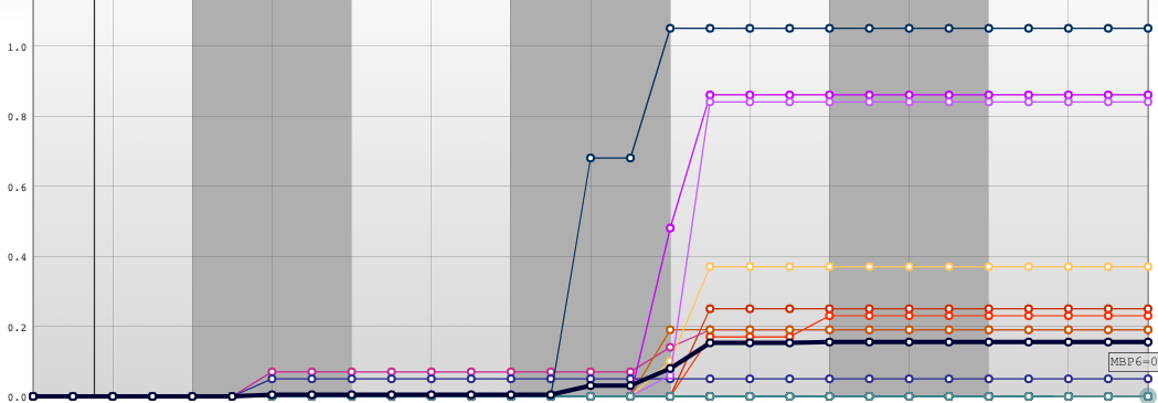 Regardless of where you live snow & black ice will be a concern Thursday morning and again Friday morning. With snowfall and ice a larger concern for the plateau, Smokies, and northern valley (bordering Kentucky) use extreme caution if you must be out on the roads. Take your time, give yourself plenty of distance to make a decision, slow down. 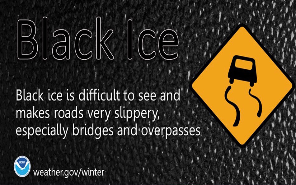 For more information, view our daily video forecast below and check out @SecretCityWx on Twitter & Facebook. We'll continue to update the latest on our social media outlets which can also be found on the right side of this page (scroll down a bit). Reports tonight through Friday would be great and you can do so by commenting here, tagging us on Twitter/Facebook, or emailing those to us at [email protected] Pre-recorded for 5pm show
I'm wishing everyone a warm Tuesday as current temperatures (as of noon) are in the upper 20's across the valley and teens for the plateau. Unfortunately, things won't warm much over the next few hours with high's hovering under freezing (32) for the day. 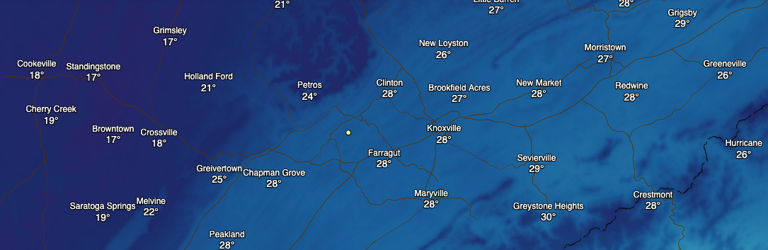 Looking at the latest radar scan, snow shower & flurries continue for parts of Morristown, Jefferson City, and northeast Tennessee. These will carry on through the early afternoon before drier air finds us this evening. Overnight, broken cloud cover and cold air will lead to low's in the teens and 20's. We warm up a bit tomorrow in the low 40's before another blast of cold air, wintry precipitation, and messy conditions find us Wednesday night through Friday morning. 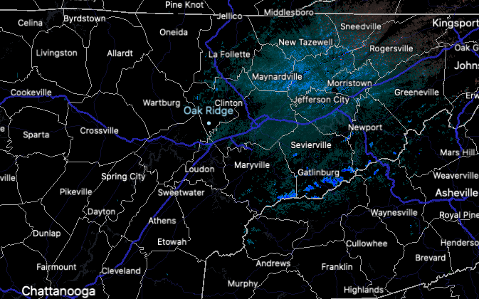 As another powerful winter storm barrels closer, rain to freezing rain will start out Wednesday night. Low temperatures into Thursday morning will hover right at to just above freezing. Given the warm up expected tomorrow, this should help keep pavement temps above freezing, and therefore, rain will be the dominate faller into Thursday (for the valley) Nonetheless, I do anticipate freezing rain to build up for those in the higher elevations, specially the plateau. As temperatures warm into the upper 30's and 40's Thursday afternoon, rain will fall before a transition back to frozen matter Thursday night. The two time periods of most concern are Thursday morning and Friday morning for freezing rain and slick spots. Snow, for the valley, looks to be out of the question for most of this event. A few flurries to a light dusting is possible Friday morning, but the main concern will be iced roads and slick spots. We'll have more details on exact timing, impacts, and precipitation tomorrow. 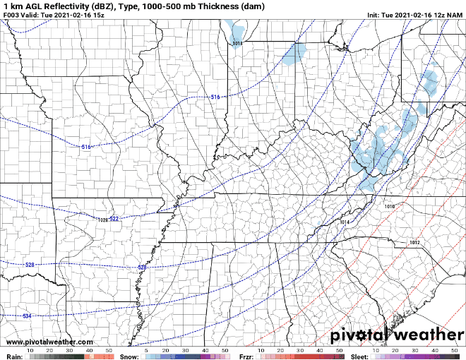 Do your best to stay warm today and tonight. This is a reminder to bring in any outdoor pets you may have as well. We will have more details tomorrow, but buckle up for another wintry mess across East Tennessee. Don't forget to check out our daily video forecast below as well. Pre-recorded for 5pm show
Freezing rain remains the biggest concern today through Tuesday morning. As a system works in a northeast direction, warm air aloft and cold air at the surface will lead to dangerous roadways, the potential for downed trees, and the loss of power for the Plateau & northwestern East Tennessee. The remainder of the Valley will see rain with a chance for freezing rain, sleet, and snow tonight into Tuesday morning. Slick spots will be possible so use caution if you are planning to be out on roadways tonight into Tuesday. The main concern remains for the Plateau though with icing totals up to 0.3 inches. Snow will also be a concern tonight with 1-3" possible overnight (this could be on top of already iced roads). If you can avoid being on roadways in these locations, it is highly recommended you stay home. 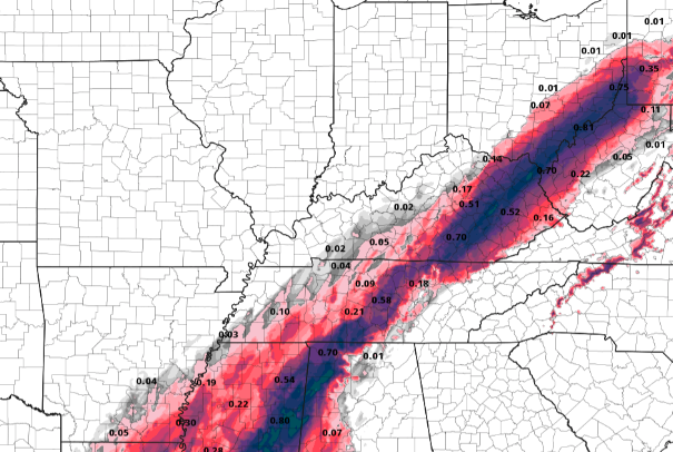 Looking at the play by play, we sit in the preferred spot. Warmer air down to the surface will lead to mostly rain through the Valley today and overnight. A brief transition to wintry precipitation will be possible overnight but little to no snow/ice accumulation is expected. Transitioning into Tuesday, we begin to dry back out but stay chilly. A second system (very similar to this one) brings another blast of cold air, rain, and wintry precipitation. As of now, the path seems very similar, again leaving us mainly in the rain shield. This will arrive overnight Wednesday and throughout Thursday. We'll provide more details on this one tomorrow.  Mid-February continues to look cold as the latest CPC release suggests below average temperatures in the week ahead. Tying this with precipitation, above average is anticipated. This will easily wipe our drought deficiency that much of the state has faced. 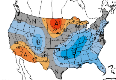 Continue to check in for updates as weather conditions for a portion of the region will be messy and dangerous. If you are in the Plateau and must be on the road, use extreme caution and take your time. Valley locations could see some slick spots this morning through tomorrow, so take it easy. I hope everyone enjoy's Washington's Birthday today. Stay safe, warm and dry out there! pre-recorded for 5pm show
|