|
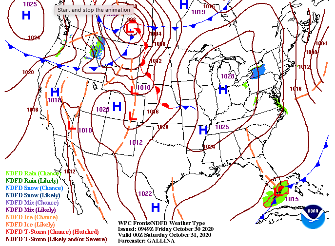
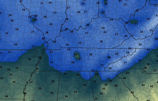
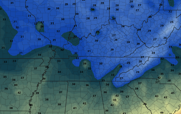
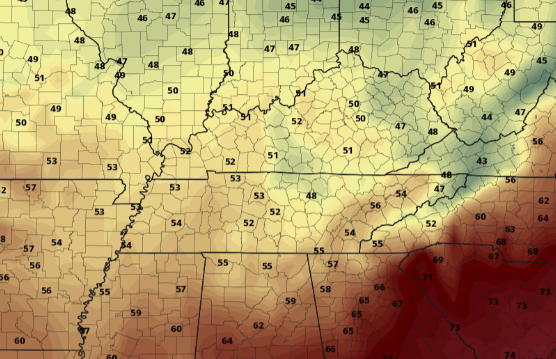
Good morning! I hope everyone has their coats handy as things don't look to warm up much through the day. With a high pressure system slowly working its way in from the west, most of us will stick with high's in the mid 50's under improving skies. Saturday and Sunday will be a bit warmer with high's in the lower 60's. Another blast of cold air will bring the coldest temps of the season, and likely, force many to bust out their winter coats. A look across the nation for the next several days shows a quite pattern here at home. Though not significant, a few sprinkles can't be ruled Sunday afternoon. As a low to the north works east, a cold front will slide in later Sunday. This could bring the potential for a few sprinkles during the day, otherwise things stay dry with sunny skies most of early next week. With a secondary cold front late this weekend, how will we fair temperatures-wise? Well to give it to you short, COLD. I anticipate the NWS in Morristown to place a freeze warning across the entire area overnight Sunday, essentially ending the growing season. With cold temps to start the day, things don't look to improve much with high's in the 40's and low 50's Monday afternoon. I anticipate the NWS to release an official rainfall amount total from Zeta sometime today, so we will distribute that via social media when that comes out. As for today and this weekend, it'll be cool but Monday is our focus. Have a good weekend and dust off those winter coats for a cold start Monday morning.
0 Comments
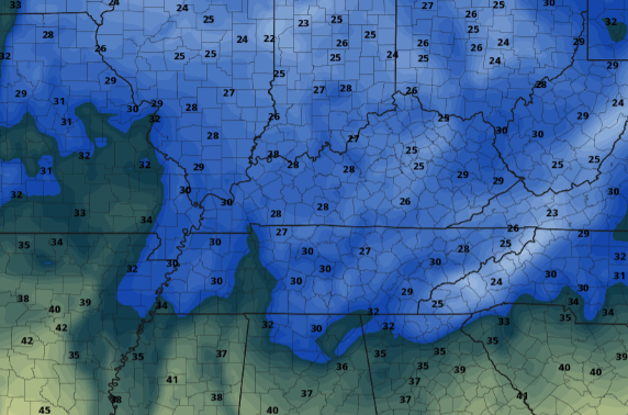
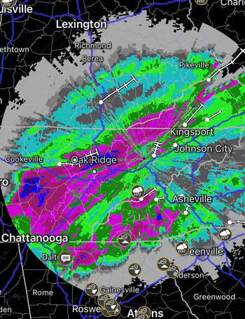
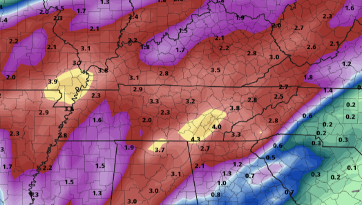
Rainfall continues this morning as Zeta works to our north and east. The good news is we'll see showers begin letting up later this morning with a few isolated showers in the afternoon/evening. As of this morning, check out radar indicated rainfall over the course of this event. Scale: Pink: 2.5 inches Dark Pink: 3 inches Blue: 4 inches Purple: 5 inches We'll see the official release of rainfall totals later today or into Friday by the NWS. As you can tell and I'm sure you've seen, lots of rainfall has fallen across the area in the past 24 hours. We do have some better news in the forecast though as showers from Zeta begin letting up later this morning. By the afternoon, a few isolated showers on and off with be possible but the clearing process begins overnight. A cold front slides through bringing chilly air tomorrow. High's will range from the upper 40's to mid 50's under decreasing clouds. The trend looks to continue for Saturday as well with sunny skies and high's in the low 60's. For Sunday, a secondary front will glide through the second half of the day. This winter-like front will bring the coldest temperatures of the season to begin the new work week. High's on Monday will be lucky to find 50 degrees. A look at the cold air expected overnight Sunday shows low's in the 20's and low 30's. With the growing season technically not over by NWS standards, I fully anticipate freeze watches (to eventual warnings) to go into effect Sunday night/Monday morning. This, in-turn, will end the growing season officially. Lots of rain has fallen in the past 24 hours, so be weary if you are out and about and remember to never drive through flooded road ways. We'll see improving conditions this evening and through early Friday with sunshine returning. A few rounds of cold air masses will also find East Tennessee, so have those winter coats handy. Have a good day and stay safe! We've seen a few isolated showers so far early this morning, otherwise things have stayed cloudy. Working into the day, showers will become more widespread and the intensity will also pick up. As of last night, the WPC has placed all of East Tennessee under a Slight risk (10-20%) chance for flash flooding. Given model trends, especially the higher resolution short term ones, I would not be surprised to see the WPC up some areas to a moderate risk. We will keep a close eye throughout the day and keep you posted. For now, a pair of low's, one to the west and the other (Zeta) from the south, will bring heavy rainfall across all of the Mid-Atlantic states. Particularly here at home, trends have agreed to the more eastward orientation & path as I likely hinted would be the case yesterday. With Zeta likely working right through parts of East Tennessee, heavy rainfall will impact us overnight. With the rainfall we will see throughout the day toppled with a heavy dose overnight, flash flooding could quickly become a concern into early Thursday. Be sure to have a way to receive alerts if you are in flood prone areas. As of this morning, NWS Morristown has issues a Flash Flood Watch for the entire area running from 8pm tonight to 2pm Thursday. A nice dose of rainfall is expected across the entire region, but things will likely be the heaviest across our area. Current models are trending between the 2 and 4 inch mark with locally higher amounts of 5+ inches possible in some locations. The good thing is we have been quite dry this week, so I am hoping this helps reduce flooding potential. If you would like to send us reports, you may do so by email [email protected] or through social media. We will also pass those along to the NWS. Once Zeta is all said and done, a high pressure system and much cooler air arrives Friday. High's are expected to top out in the 50's under clearing skies. Looking longer term, a secondary blast of cold air arrives late Sunday bringing the coldest air of the season. Temperatures to start the morning Monday will be in the 20's (for higher elevations) to lower 30's here in the valley. I anticipate a frost &/or freeze warning to be issued across the area (ending the growing season officially). With lots of weather expected the next several days, keep up to date here and through our social media pages. With heavy rainfall expected through today and tonight, have a way to receive alerts. For more information check out the video forecast below as well as last night's video forecast (geared toward Zeta). Pre-recorded for 5pm show
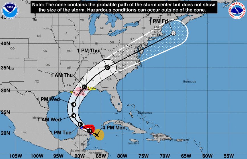
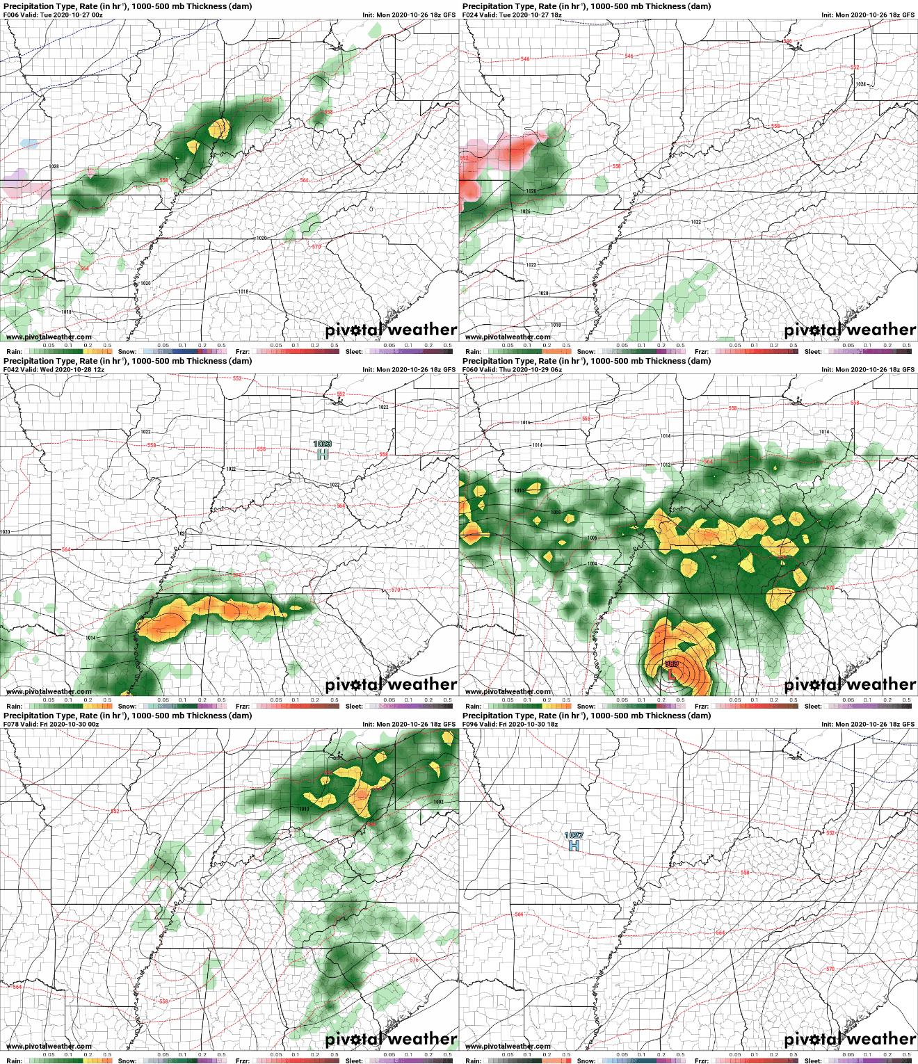
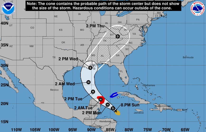
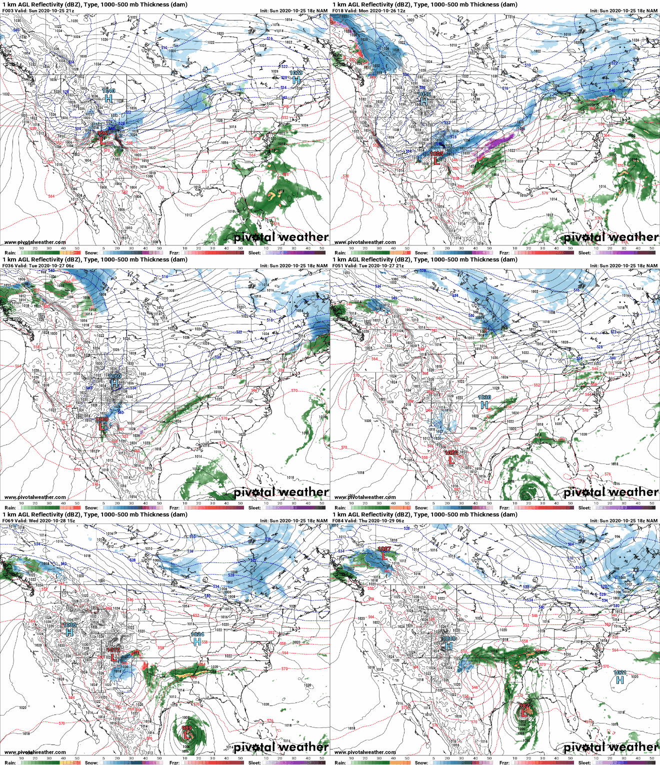
Just wanted to provide an update in regards to the remnants of Zeta with timing, rainfall amounts, and likely path. We also highlight cooler air to follow. Continue to check back in with us as changes are more than likely in the day ahead. Good morning! We are seeing some patchy fog in spots this morning with temperatures in those mid to upper 50's. Things will stay pretty similar to yesterday with partly to broken skies and high's in the lower 70's. The big story, of course, is now hurricane Zeta. Model guidance continues to try and solve this systems path given the current weather features we have across the US. With this current model (below), two independent systems will work through. One, a cut-off low currently in the Plains and two, remnants of Zeta. The second option is for these two systems to essentially morph together to our west. For option 1.... In this case, heavy rainfall and the potential for flash flooding will be present late Wednesday and throughout Thursday. Model guidance has rainfall totals in the 2-5 inch mark depending on where you are. For option 2.... A westward track will leave significantly less rainfall across the eastern half of the state with rainfall totals in the 0.5 to 1.5 inch range. Given the uncertainty in tracks as of late last night/early this morning, I anticipate a more eastward track (similar to the NHC). This leads me to believe higher rainfall totals are likely across the area the second half of Wednesday and throughout Thursday. Check our daily video forecast below for more details. Regardless of the track, much cooler air will build in behind this system for Friday. A 15+ degree swing in temperatures can be expected with high's Friday lucky to top 60 degrees. This cool bed of air will stick around all weekend as well with high's in the lower 60's for Saturday and Sunday. Once Zeta gets closer to land, we will have a track better pinpointed out. For now, anticipate a more eastward track similar to the model above as well as the official National Hurricane Center track at the top of the post. As you can tell, there is still many things that need to be paved out, so check back in for more details and stay posted with us on social media. Good morning and I hope everyone enjoyed their weekend! A big change in weather conditions is ahead this week as the Tropics are again very active. Zeta, now a Tropical Storm, is expected to strengthen to hurricane status as it works north and eventually east later this week. Given the latest path from the NHC, we are anticipating a heavy amount of rainfall late Wednesday to early Friday morning across the region. For now, we stay in a stable state of cloudiness and mild afternoon temperatures. A system to our north and west will keep broken cloud cover around today and parts of Tuesday before bands of rainfall arrive Wednesday from Zeta. As you can see, Zeta will continue strengthening as it enter Gulf waters, eventually making landfall Wednesday near Louisiana, Mississippi, and Alabama. Trends keep remnants of Zeta to our east through the week, but we could still pick upwards of 2" in some spots. Once Zeta works out, a strong cold front slides through dropping afternoon high's into the upper 50's to low 60's on Friday and keeping things on the cool side through the weekend. Continue to check back in the next couple of days as Zeta will likely make an impact across east Tennessee. Path and rainfall totals vary with these tropical systems, so we'll continue to provide you the latest as we get closer to time. For now, enjoy mild temperatures under a mix of clouds. Pre-recorded for 5pm show
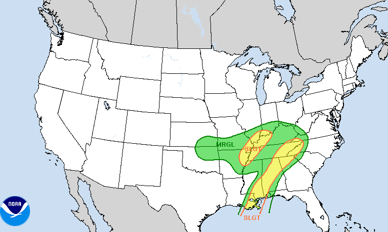
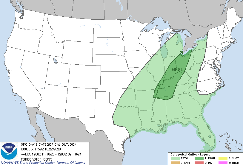
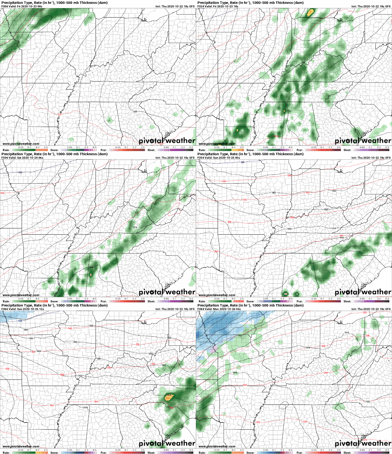
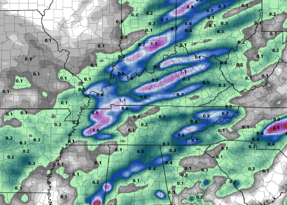
Finally the end of the work week has arrived but with some changes in the weather forecast. We are starting the morning with patchy fog and partly cloudy skies and will transition to partly cloudy skies this afternoon. High's remain warm in the upper 70's with clouds increasing throughout the later half of the day. A look at the SPC shows a Marginal Risk for severe storms just to the west. A line of showers & storms ahead of a cold front will work through late tonight and into Saturday morning. The good news is these will weaken as they move east, but some thunder/lightning and some gusty winds aren't out of the question. Looking at model guidance, we see light scattered showers across East Tennessee initially tonight. Working further into the overnight hours and into Saturday morning, the line associated with a cold front will work through. As mentioned, the heavier showers/storms will stay to the west but a few strokes of lightning and gusty winds in heavier pockets are possible as we get into Saturday. By Saturday afternoon, things will calm back down with cloudy skies overhead. Sunday and early next week will all be similar with partly to broken skies and a few afternoon isolated showers possible. Rainfall totals through Saturday afternoon will be in the half an inch to inch mark. Totals will vary given heavier pockets of showers/thunderstorms will provide more rainfall, but overall upwards of half an inch will likely be the average. With severe potential very low, this will be a good opportunity to receive a fresh bed of rainfall and keep any potential drought at bay. That will wrap it up today, but we will be providing updates on social media as this line of showers works closer. If you don't follow us on Twitter or Facebook, you can follow along by viewing our tweets along the right side of this page. Have a great weekend and anticipate a big swing in temperatures in the next 7-10 days (more details to come Monday). Pre-recorded for 5pm show
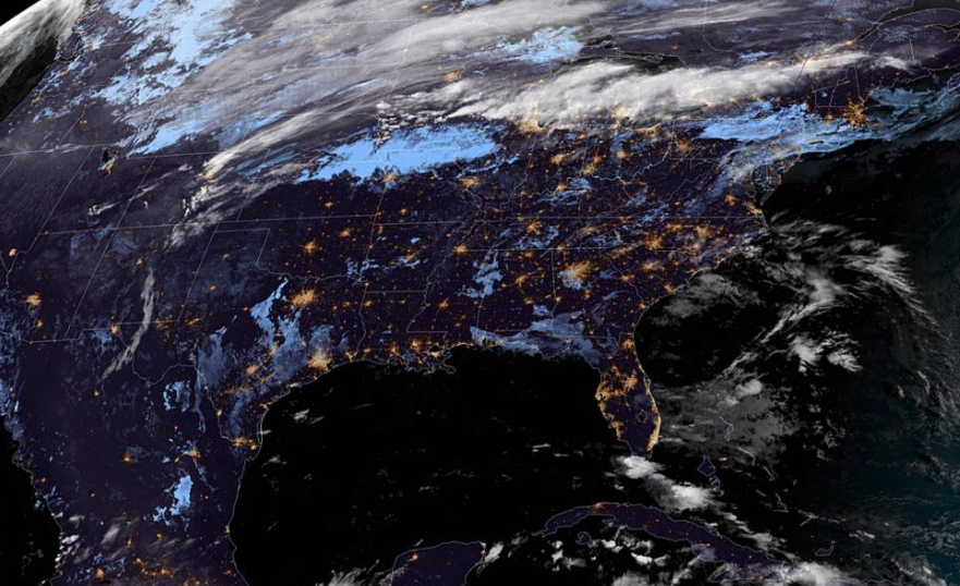
GOES-16 East paints a pretty picture this morning with limited cloud cover encompassing the southeast. Unfortunately, we'll see some changes to this picture Friday and early into the weekend but things stay warm and dry today. In fact, high's will return to near 80 degrees under mostly sunny skies. The forecast ahead remains relatively the same. Cloud cover will build in for the second half of Friday bringing with it the chance for isolated to scattered showers. This looks to continue into Saturday as well where a weak cold air mass follows. This will cool things down Saturday afternoon to highs in the low to mid 70's before warming temperatures return Sunday and early next week. Overall, Saturday will be our best day for shower activity as this line works its way through. With how dry and warm we have been the past several days, a fresh bed of rainfall will be nice in helping to prevent drought conditions to return across the state. Longer term, we will likely see rain activity pick back up across East Tennessee as the pattern looks to change late October/early November. As we highlighted yesterday, much cooler air is expected to return later this month, bringing high's back down below average. For now, do your best to enjoy the warm and somewhat sticky air we have through the end of the week and into next week. A good Wednesday morning to you! Looking overhead I-40E in the West Hills area of Knoxville, things are quiet (weather-wise). We can see there in the background, as well as satellite, things are mostly clear to start the day. For the day itself, anticipate it to be relatively warm with sunny skies and high's around 80. With a high pressure system remaining just to the east, return flow from its anti-cyclonic (clockwise) circulation is allowing warm air to funnel in. Changes do come later Friday as cloud cover and a chance for limited moisture work across the region. A look at model guidance paints the story. Things stay warm and dry today and tomorrow before a low moving through the Great Lakes brings showers and a weak cold front through East Tennessee. This next system won't be too impressive with upwards of a few tenths of an inch possible Friday and Saturday. Longer term is where we will see the largest changes with another shot of cold air and the chance for heavier showers and storms. For more details into when you can expect this shot of cold air, watch today's video forecast. A little hint though, we will more than likely find high's back into the 50's and low's into the lower 30's to upper 20's. Until the swing in conditions, expect things to stay at to above average with a mix of showers scattered in for early this weekend and again early next week. Pre-recorded for 5pm show
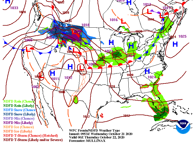
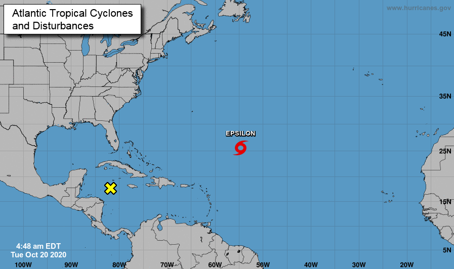
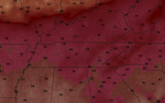
We are seeing some patchy fog hanging around parts of the valley this morning, so account for a little extra time to work & school. A look into the Tropics shows a familiar seen this year: more activity. Tropical Storm Epsilon is currently in the mid-Atlantic and will banana north and east with time. Epsilon does not pose a threat to the US in the days ahead. However, an area of low pressure sits to the east of Mexico bringing the potential for weaker activity in the days ahead. For now, this system has a less than 40% chance of forming in the next 48 hours. With high's today topping out near 80, the warm trend will continue for Wednesday and Thursday. A look at high's tomorrow shows temperatures nearly 10 degrees above average. The same can be said for Thursday as well before cooler air arrives with rain chances into the weekend. A high pressure system is placed just to our east. This is what is keeping dry air in place for East Tennessee and gives the weird orientation of the system to our north. This is also why we have been so warm and will continue to be tomorrow and Thursday. The return flow of the ridge is funneling in warm southern air. As we work ahead, showers to our north (Kentucky) will wade out, leaving sunny skies Wednesday and Thursday. By Friday, a new system arrives bringing the potentials for isolated showers through the day and into Saturday. That will wrap it up for today, but as always, thank you for choosing Secret City Weather. Pre-recorded for 5pm show
|
Your trusted source for everything weather in East Tennessee.
Social Media
|

