|
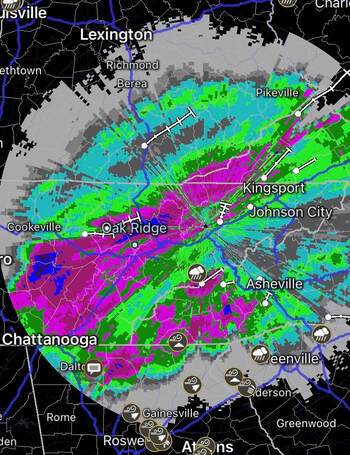
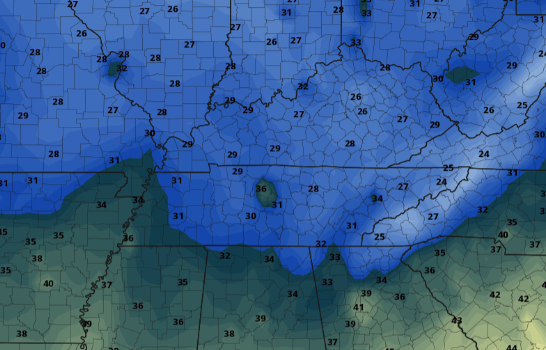
Rainfall continues this morning as Zeta works to our north and east. The good news is we'll see showers begin letting up later this morning with a few isolated showers in the afternoon/evening. As of this morning, check out radar indicated rainfall over the course of this event. Scale: Pink: 2.5 inches Dark Pink: 3 inches Blue: 4 inches Purple: 5 inches We'll see the official release of rainfall totals later today or into Friday by the NWS. As you can tell and I'm sure you've seen, lots of rainfall has fallen across the area in the past 24 hours. We do have some better news in the forecast though as showers from Zeta begin letting up later this morning. By the afternoon, a few isolated showers on and off with be possible but the clearing process begins overnight. A cold front slides through bringing chilly air tomorrow. High's will range from the upper 40's to mid 50's under decreasing clouds. The trend looks to continue for Saturday as well with sunny skies and high's in the low 60's. For Sunday, a secondary front will glide through the second half of the day. This winter-like front will bring the coldest temperatures of the season to begin the new work week. High's on Monday will be lucky to find 50 degrees. A look at the cold air expected overnight Sunday shows low's in the 20's and low 30's. With the growing season technically not over by NWS standards, I fully anticipate freeze watches (to eventual warnings) to go into effect Sunday night/Monday morning. This, in-turn, will end the growing season officially. Lots of rain has fallen in the past 24 hours, so be weary if you are out and about and remember to never drive through flooded road ways. We'll see improving conditions this evening and through early Friday with sunshine returning. A few rounds of cold air masses will also find East Tennessee, so have those winter coats handy. Have a good day and stay safe!
0 Comments
Leave a Reply. |
Your trusted source for everything weather in East Tennessee.
Social Media
|


