|
Good afternoon! After a wet and dreary week prior, we start this one off sunny and mild. In fact, today will be the coolest day of the 5-day span. Friday highs will be in the upper 60s and low 70s for most. Looking across the Smokies from the Newfound Gap camera, sunny skies dominate, with not even a cloud in the sky. 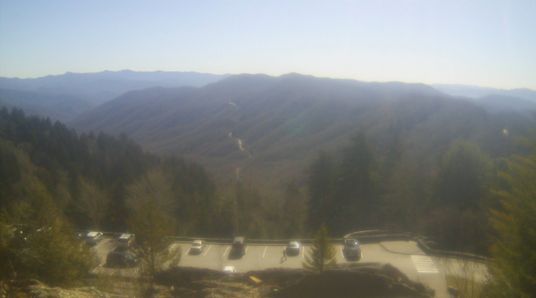 With high pressure dominating the greater portion of the Eastern US, sunny skies and warming temperatures will be the trend this week. As such, our best chance of rainfall doesn't arrive again until the weekend and early next week. Forewarning though, the long term outlook appears to be a wet one. Overall, above average rainfall is anticipated for the month along with near to above average temperatures.  That will do it for today....enjoy the warming temperatures and sunny skies! We'll catch you back here tomorrow. Pre-recorded for 5pm show
0 Comments
The last of the showers are working across this morning and should exit over the next couple of hours. A cold front runs along Middle Tennessee and will allow for the advection of cooler air across the state through today. As a result, anticipate "peak temperatures" for the day to come early, with afternoon temps in the low to mid 50s.  After variable temperatures this week, a swing toward warmer air is on the way. This week will see above average temperatures, with the trend looking to continue for the first week of March. This could bring a wrap to Winter, with very limited options (as for snowfall potential) expected over the next month and a half.  In addition to temperatures, rainfall has been significant this week. From Monday night through this morning, our station picked up exactly 6.5 inches of rainfall. Several locations, namely the Northeast, were under flash flood warnings yesterday morning/afternoon. Several rivers are also running very high and I anticipate that to continue today as things slowly begin to recede. As for the precipitation outlook for the first week of March, a fairly average forecast is on tap. The week ahead will be mostly dry before a transition back to near average.  We will see a final opportunity for scattered showers to a few flurries (for the valley) Saturday night into Sunday, as a quick moving system clips us to the south. Sunnier skies then follow Sunday afternoon and we trend warmer through mid week. Have a great weekend and enjoy above average temperatures on Sunday.
Good morning! Moderate to heavy showers are currently aligned across the northern half of the area. This will leave a lull in activity for the southern half of East Tennessee through this afternoon, before a cold front with a line of heavy showers (and isolated storms) works across tonight. 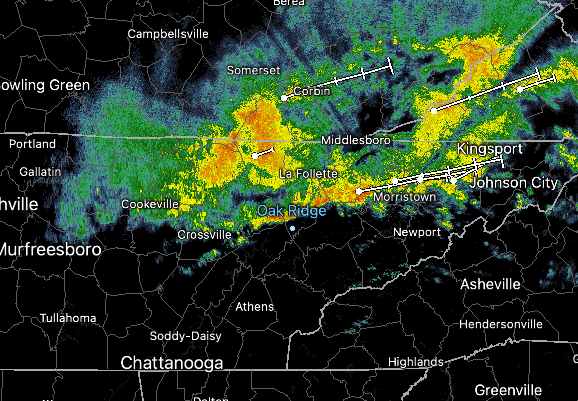 Given this morning activity, followed by additional showers tonight, the National Weather Service in Morristown has issued a Flood Watch through 1 pm Friday for counties highlighted in Green. Many locations have picked up significant rainfall already, leading to river flooding (highlighted neon green). Additional rivers could be added to this by tonight, so use caution if you live near these locations. 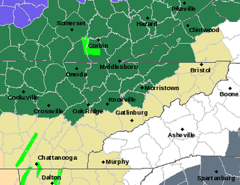 Additionally, the WPC has highlighted a Slight Risk for flash flooding today. Again, given the saturated soils from our previous storm system, flash flooding & flooding can quickly occur. Have a way to receive warnings today and Friday! The most primed locations are those near water bodies, low-lying areas, and common flash flooding/flooding points. 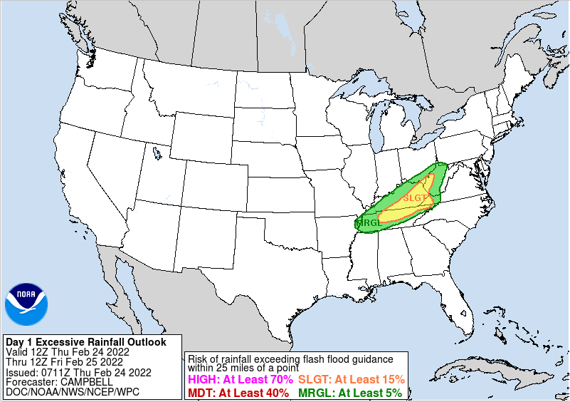 Here is the latest run showing showers lining back up tonight ahead of an approaching cold front. Not only will this bring moderate to heavy showers (and a continued flood threat) but also cooler air Friday and Saturday. Luckily, warming conditions return Sunday and into next week. A weak and quickly passing disturbance could also bring isolated shower/snow chances Saturday night, but guidance continues to back off on the idea.  Stay alert throughout the day and use caution. Even for those at a lesser risk for flooding/flash flooding could encounter ponding roadways during the morning and evening commutes. Have a good one, be safe, don't forget to follow us on social media (@SecretCityWx) and send us any reports of flooding you hear/come across.
Good morning! After heavy rainfall, things are beginning to quiet down. The last of showers are along the Smokies and should exit over the next couple of hours. For those who don't follow us on Twitter/Facebook, one: you should and two: we picked up between 2 and 3" from Tuesday morning to this morning. As a result, there have been many reports of flooded creeks, low crossing areas, and river floods. Looking at the map below, oranges signify flooding, while yellows indicate soon to be flooded water bodies. Use caution, share reports, and prepare for some more rainfall in the days ahead.  Looking at the play by play, a warm front will build north bringing showers late tonight and Thursday morning. This will be followed by a lull in activity and then followed with moderate to heavy showers tomorrow night and into early Friday. Overall, another 1-2" is possible, with the southeast seeing the least and the Plateau and northern Valley seeing the most. Saturday will bring the return of drier and cooler conditions before another system brings a renewed (but lesser) chance of rain.  A quick look at the temperature change, the cold front will pour in cooler air today. Most will top out early with highs in the upper 50s to low 60s. Warmer air returns tomorrow, before another blast of cooler air Friday and into the weekend. A few could even see a few isolated snowflakes Saturday into Sunday (higher elevations). 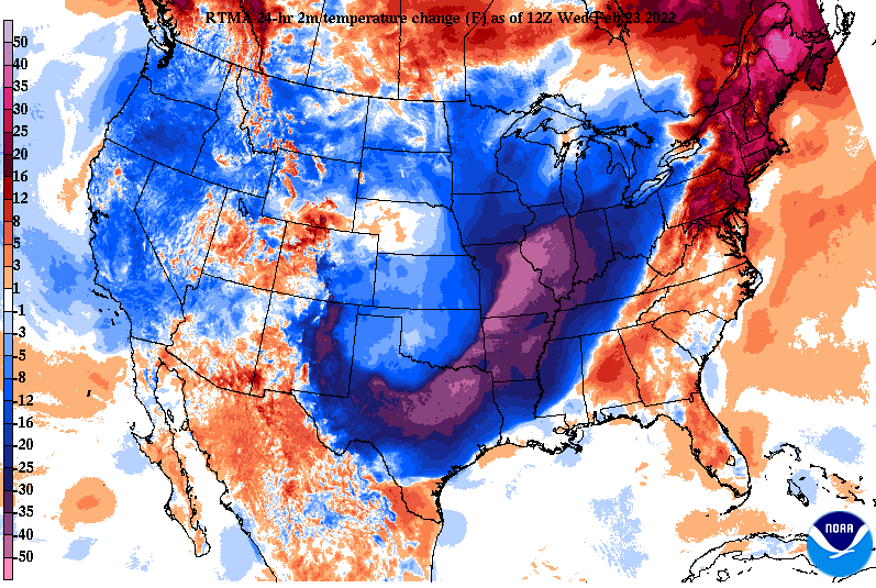 With ongoing river flooding and more rainfall on the way, I anticipate added issues. Luckily, this next round will impact Kentucky much more than us, allowing for waters to recede a bit. Nonetheless, have a way to receive watches and warnings, as saturated soils will likely bring more ponding to roadways, higher rivers/water bodies, and localized flooding/flash flooding. Pre-recorded for 5pm show
Good morning! Most of the rainfall has vacated, through a few scattered showers throughout the day are possible. For the most part, today will be cloudy and breezy. Winds out of the southwest will blow between 5-15 with gusts up to 25 mph. As we work into tonight, heavy showers and a few storms will work in. Due to the heavy nature expected, a flood watch has been issued until tomorrow night at 7pm for the areas highlighted in green. Prepare now if you are in flood prone areas and have a way to receive alerts. 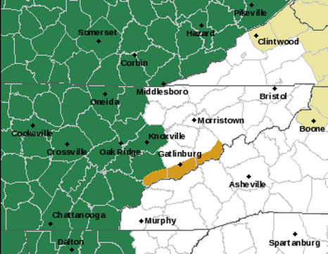 Breaking it down, a heavy band of showers and isolated storms will pivot across the area tonight. As this axes shifts east, we'll see a lull in activity once again for Wednesday. A secondary system will then work in bringing cooler air on the tail end. This will arrive late Wednesday night and through Thursday. Again, 1-3" will be possible with this system, bringing a grand total of up to 5-7" in total. 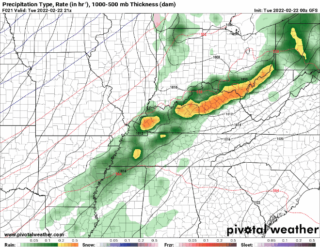 This biggest uncertainty is where the heaviest band sets up and eventually pivots. Earlier runs pinned this further north but more recent runs have this a bit further south. If this trend continues, we could see this lined up across portions of Tennessee, and this could cause significant issues. Red's highlight 2-3 inches, while purple signifies 4-5+ inches. Keep in mind this is through Wednesday night and doesn't include most of the second system rainfall. This is also a raw model run, meaning take it with a grain of salt. Furthermore, other higher resolution models indicate much less rainfall overall, in the 1-2" ball park. We will see how things play out, but the best opportunity will be just north and west. 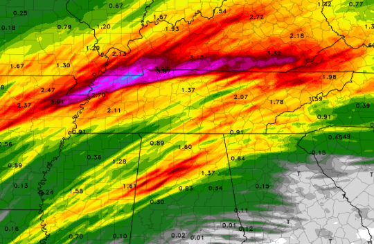 We will continue to keep a close eye on this, but have a way to receive alerts and prepare now as if flooding is expected. Those in low lying areas, near water bodies, or near common flood points will be the most at risk. Cooler and drier air will find us early weekend, before more shower opportunities find us Saturday night and into Sunday.
Happy Holiday! Diving right into this week, lots of rainfall is in store. Two systems will impact the area, one arriving tonight and Tuesday night, and a second Wednesday night and through Thursday. For system number one, a slight risk (15% chance or greater) of flash flooding is in place. Some locations (just to our south) even have a moderate risk (40% chance or greater). Have a way to receive watches/warnings throughout the week, as heavy rainfall will bring that potential. This is especially so for locations near water bodies, low-lying areas, and flood prone locations. 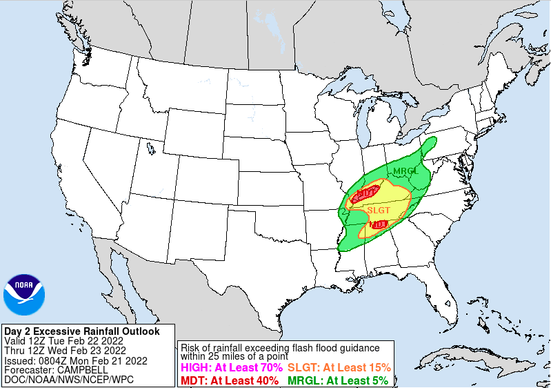 The 1-3 day outlook (now through Thursday morning) shows 2-3 inches of rainfall, with locally higher amounts across the far south and across Western Kentucky. Our second round arrives Wednesday night and through Thursday, bringing an additional 1-3 inches. In total, 5-7 inches isn't ruled out for the week, creating the opportunity for significant impacts. There is some uncertainty on where this axes of heavy rainfall lines up, but guidance is coming into better agreement this will be off to our north and west (good news). 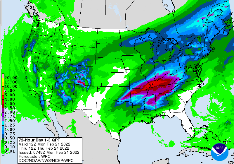 Here is the break down of system number 1. Showers will arrive tonight and into early Tuesday morning. This will be followed by a lull in activity for the greater part of the day, before heavy showers and isolated storms arrive tomorrow night and into early Wednesday. Our next round then arrives Wednesday night and into Thursday.  Continue to check back in with us and don't forget to check out our video forecast below as well as our "radar" tab if you want to see what's going on around you. Be safe, have a way to receive watches/warnings (if issued), and send us any reports you may have in the coming days. Pre-recorded for 5pm show
For those who have not left the house yet, be sure to throw on a jacket. Much cooler air will filter in today, as a cold front recently passed through and now sits to our east. As a result, highs today will top out in the upper 30s and low 40s. Cloud cover will hold strong through the first half of the day, before sunshine edges back in later this afternoon. Fortunately, a warming trend will find us through the weekend and into next week. 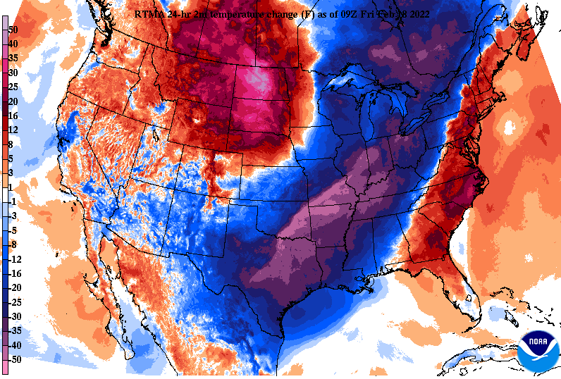 Our eyes are now focusing on our next weather maker. This next system looks to bring a flash flood/flood threat. Lots of rainfall is expected over the next 7 days, which is why a slight risk is already in place for Day 5 (Tuesday into Wednesday). For those near water bodies, common flood and flash flood points, or low-lying areas, begin preparing now. Rainfall will not only impact us Tuesday, but a majority of the work week. 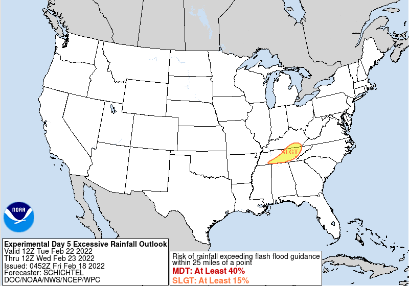 In fact, looking at the 7-day outlook, between 5 and 7 inches of rainfall is expected from day 5 to day 7. That is a significant amount of rainfall, which could pose major issues if it comes to fruition. We will monitor it closer, but for now enjoy the sunshine this weekend and the warming temperatures. 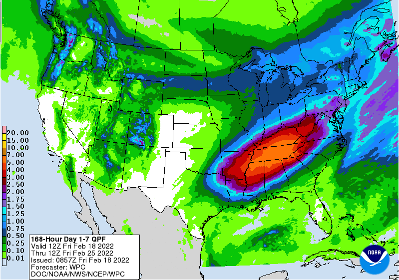 Have a good one! Washington's Birthday should be a warm one with highs in the low to mid 60s. Cloud cover will increase throughout the day, leading to showers overnight and through midweek. Be sure to check back in Monday, as flooding/flash flooding looks increasingly likely next week.
Good morning! An active day is upon us with yet again very warm temperatures and even more breezy winds. Looking at the change in temperatures from this time yesterday, we are much warmer. In fact, that is the trend for the entire eastern third of the US, with much cooler air slowly pushing its way east. This is associated with a cold front, which will cross the area tonight and into Friday, and be the driver for storms later today. 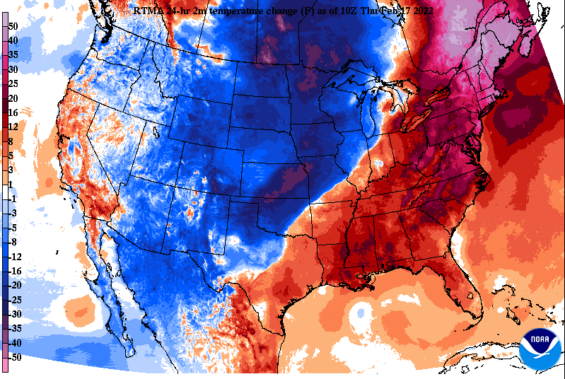 As we saw/felt yesterday, breezy conditions will hang around today. Guidance depicts gusts upwards of 40-50 mph during the afternoon. I will note most of this should be prior to the onset of thunderstorms and be defined as non-convective winds. This will continue to pump in VERY warm and moist air. Highs today will range from the upper 60s to low 70s, with some locations nearing the mid 70s. Though this is very warm and roughly 20 degrees above average, we will still be a ways off from the record 79 degrees recorded on this day.  The SPC has pinpointed a bullseye for the best severe potential and that is Northern Alabama/Mississippi and the western half of Tennessee. Guidance has actually been pushing for a more northern trend, so I would not be surprised to see the better potential more into Tennessee. Nonetheless, showers will be possible (isolated to scattered) through the early afternoon, before a line of storms works east. Within this line, all severe weather will be possible. The main threat will be damaging wind gusts (60 mph+), but large hail (3/4" +), and tornadoes are also possible. The biggest threat will be to our west & southwest, but this doesn't mean we are out of the woods. Flash flooding and flooding is also a concern, though with how progressive this system is and how dry it has been, we should fair better than worse there. 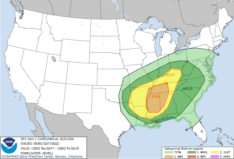 The break down of activity can be seen below. The timing we provided yesterday remains pretty well on track, but in case you missed it: Initial Timing For Strong To Severe Storms: Eastern Middle TN/Plateau: 5-8pm Central Valley: 6-9pm Foothills & East: 8-11pm Following will be much cooler air to end the work week. Highs Friday will be in the low to mid 40s, with gradually warming temperatures through the weekend and mostly sunny skies. 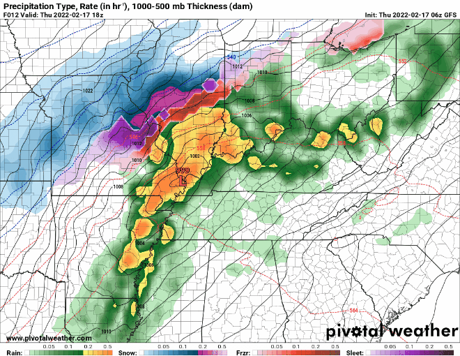 That will do it for now. Have a way to receive watches/warnings this evening and early night. Heavy downpours, lighting, and gusty winds will be possible in addition to the severe threat. We will be active on social media as well, so be sure to follow us: @SecretCityWx on Twitter & Facebook. Have a good one, be safe, and send us reports if you can! A very breezy day is in the works, as southwesterly flow will bring gusts up to 30 mph this afternoon. Likewise, tomorrow will be very similar to even more gusty, with gusts northward of 40 mph possible. I will also mention these expectations are outside of the anticipated wind gusts within showers and thunderstorms. Not only will it be breezy today and tomorrow, but also warm. Highs today will be in the low and mid 60s with highs tomorrow near to around 70. 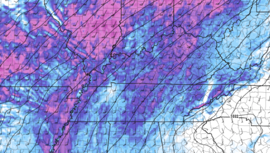 Since yesterday, the SPC has expanded the Slight risk much further east. With the later timing of this system, I anticipate a continued eastward shift. Isolated showers will start us off, but strong to severe storms along and ahead of a cold front will arrive tomorrow late afternoon (west/Plateau) to late evening/early overnight (far east). Within this line of storms, damaging wind gusts (up to 60mph), large hail, and isolated tornadoes are possible. Have a way to receive watches and warnings if they are issued and know your protected location. A flash flooding/flooding threat will also be associated with this system, as heavy rainfall is expected. 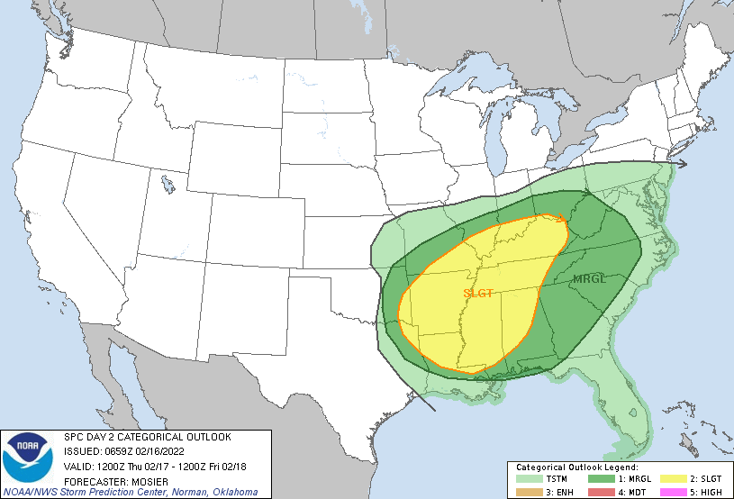 Looking at modeled guidance, here is the general run-through. Isolated showers will start us off under mainly cloudy skies. As this line takes shape and works east, strong to severe storms will be embedded within. This could allow for the development of isolated tornadoes, damaging winds, and large hail. Timing breaks down as: Middle TN/Far Western Plateau: Late afternoon/early evening (5-8pm) Central Valley: Evening to early overnight (7-10pm) Foothills and East: Late evening to the overnight (9pm-midnight)  Most activities should be fine through the day tomorrow, with the exception of wind related constraints. If you would like more information on this system, ways we can help you or your business, or even daily/weekly weather briefings, give us a shout by emailing us at [email protected] or visiting our "Contact or Services" tab above. Pre-recorded for 5pm show
The week started out quiet, but that will quickly change as we work towards Thursday. Looking at integrated water transport, you can see the large quantity of warm and moist air being pulled from the Gulf of Mexico in the days to come. This will set up the opportunity for heavy rainfall and a few strong to severe storms. 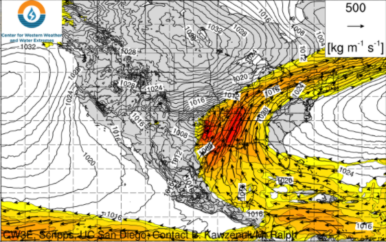 Going a step further, the SPC has issued a Marginal risk for severe storms, with the biggest threat being damaging wind gusts. It is noteworthy to mention that Wednesday and Thursday will be breezy altogether, as strong southerly flow ushers in this warm and moist airmass. As a result, anticipate sustained winds between 10-20 mph both days and gusts up to 30-35 mph. 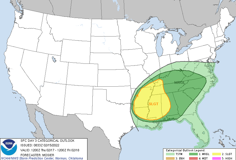 In addition to the low-end severe threat, flash flooding is a concern. The WPC has in place a Slight risk for the greater half of East Tennessee, while the remainder is under a Marginal. Given the drier conditions for the month this should aid some in limiting hydro issues early on, but consecutive heavy showers/storms could lead to flooding and flash flooding. Prepare now and use caution if you are in low-lying areas, common flood points, or near water bodies. 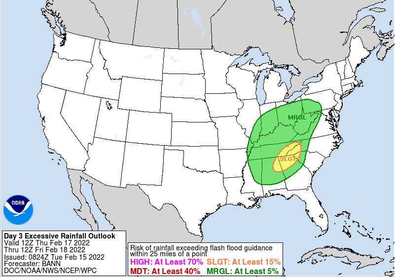 Timing will mainly come during the afternoon and evening hours Thursday. Something to watch for is how much sunshine/clearing we see. The more sunshine/clearing there is the more surface instability will grow. Think of this as energy used for the system. More sunshine will also lead to gustier winds during the day as well. This is the general break down of the system below, with fine tuning of the timing to come tomorrow. For now, prepare for breezy conditions (strong to damaging winds possible too), heavy rain, and a few thunderstorms for the day Thursday.  Following Thursday's event, cooler air will arrive for Friday. A 20+ degree swing can be expected with highs for the day to be in the mid 40s. Things begin to moderate through the weekend, with near 60 degrees returning by Sunday. Pre-recorded for 5pm show
|