|
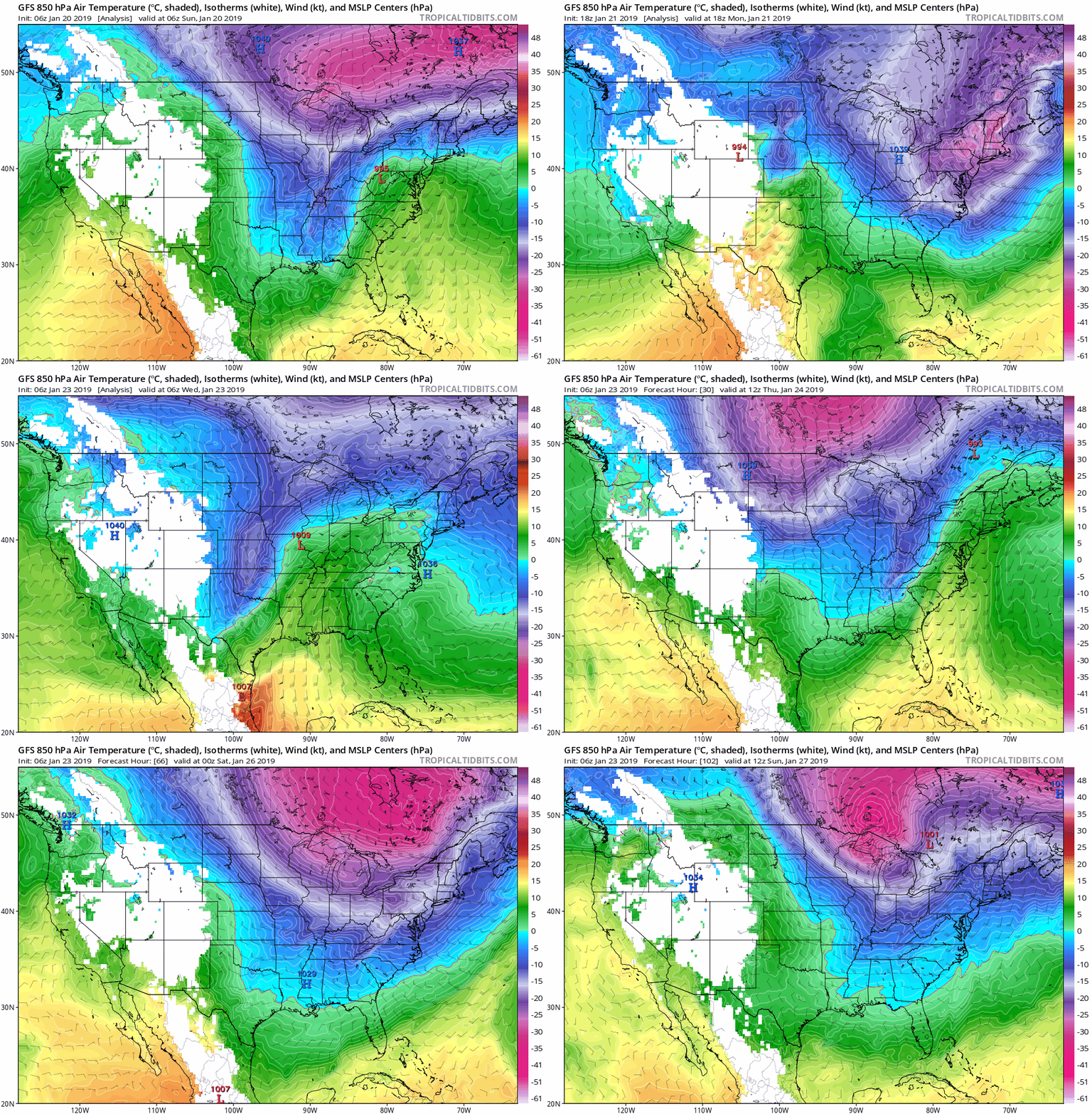
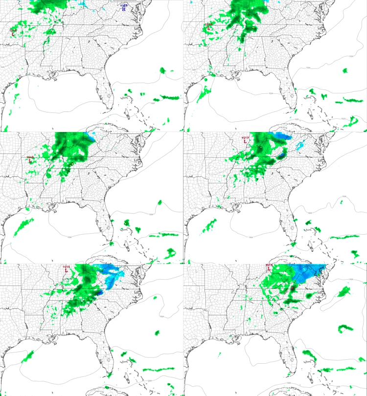
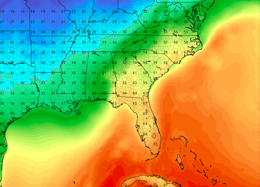
I hope everyone stayed inside as much as they could these past few days. It's been a very cold one for most of the entire US this week. Recorded high's of -20's were gathered for the Chicago area with wind chills near -50. Luckily, we are much farther south but we did see temperatures dip down to the mid teens with some isolated and higher elevations reaching single digits. Combine this with the winds and we saw wind chill ratings in the single digits to sub zero. Overall, it has been a very cold couple of days. Tonight will be yet another cold night with lows in the mid to low teens. On the bright side, much warmer temperatures are on the way. Expect with the warmer temperatures a few days of sunshine before there's a chance of rain Sunday. Below you can see the warmer temperatures and the changing pattern for our area over the next few days. We have come into the part of winter where the subtropical jet stream has become more active. Think of this as a big contributor to the weather between the US and the equator. During the winter this jet stream dips farther south, but as spring begins to take form, it will rise northward to begin effecting our area. The polar jet (jet stream for the poles) begins to head northward. These two jets (subtropical and polar) begin to "clash" creating variations in temperatures and weather. This will continue for the next couple of months until toward the end of Spring. For east TN, expect an overall warming pattern with spells of cold outbreaks in between. No doubt winter is sticking around, but Spring is starting to head its way here. Side note: these two jets are big contributors to tornadoes and "active" weather in the midwest during the Spring and Fall time periods. Below is the last North American Model (NAM) with the precipitation type forecast. Expect over the next few days for it to be drier. Lots of sun is expected into the rest of the work week before the rain finds its way back into east TN early next week. Bundle up tomorrow (Thursday) morning as temps will be in the upper teens and low 20's as you head out the door. For your high tomorrow, it will be in the upper 30's with mid 40's on Friday. This weekend is expected to be mostly sunny with highs in the upper 50's, near 60. Sunday we could see a stray rain shower, but overall partly cloudy for the day. Early next week, the rain will return.
If you haven't already, follow @SecretCityWX on Twitter and tell your friends, family, and co-workers about us!
0 Comments
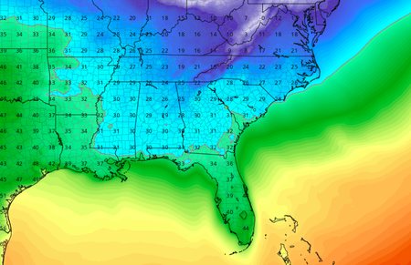
Good afternoon and happy Saturday! This next weeks system is complicated and hard to forecast. Being that this is a challenging forecast, many changes can occur from now to mid next week. With this said, the models are starting to be more in sync with their runs. In a general understanding, a low pressure system is expected to pass through the Great Lakes region late Monday night into early Tuesday morning. This will allow for a line of precipitation to pass through our area with cold air to quickly follow behind. The likely result will be precipitation falling in the form of rain (at first) and then quickly followed by a transition to sleet and snow. Cold air advection, which can be explained as cold air moving into an area of warm air, will make temperatures feel very cold and also allow rain to change to snow. The temperature outlook for this coming week looks to be the coldest of the year, and possibly the coldest for the entire winter season. Below are the temperature and precipitation type runs for the North American Model (NAM) up to Tuesday night at 7 pm. Though this is the farthest the model can run (at this time) you can see the very cold Arctic air plunging in Monday night into Tuesday. I expect temperatures to be very cold mid next week with highs in the 20's to low 30's for a few days. With the high's predicted to be very cold for east TN, adding in the wild chill values will make temperatures feel much much colder. Wind chill values for Tuesday afternoon can make temperatures feel in the upper teens at times. Wednesday will likely be the coldest of the days with high's in the mid to upper 20's. Wednesday night will have another small round of cold air making temperatures drop into the single digits and have wind chill values feel in the negatives (yes, NEGATIVE). So What About Snow Chances?This could be the first real snow for most of all east Tennessee. Like I said above, this system will likely start out as rain before quickly transitioning to a frozen precipitation. With this, I expect snow accumulations to be in the 1 to 3 inch mark for a majority of east TN with higher elevations receiving higher amounts. This means roads will likely be very messy with the combination of very cold temperatures, rain (turning to ice), and snow. With all of this said, remember the weather can always change especially since we are still days out and this being a somewhat challenging system to predict. All in all, I am pretty confident in the chances that east TN will see their first real snow of the year this coming week. Please remember if you are to be out and about this week to bundle up. Temperatures, like I said, will be extremely cold in combination with the wind chill values.
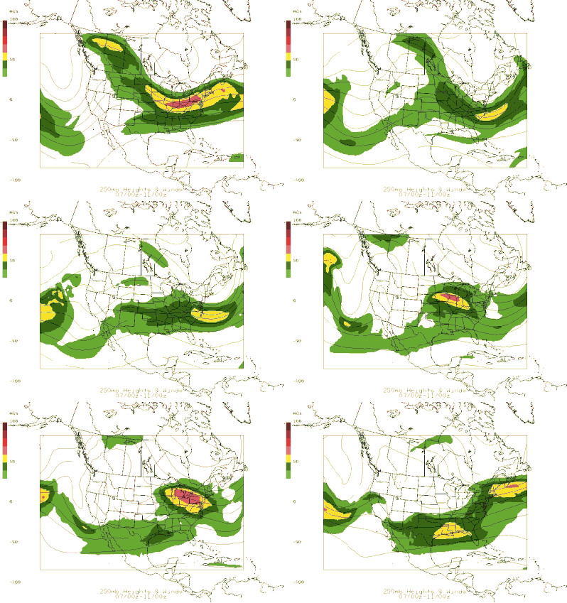
Stay up to date with here and on Twitter (@SecretCityWX) for the latest updates with this system. It is likely to change slightly and when it does, I will be here to let you know what you can expect. Until then, enjoy a nice weekend with high's in the mid 40's and partly cloudy skies before the "heart of winter for east TN" hits early to mid next week. Happy hump day as they say! Most of East Tennessee is under a WIND ADVISORY. This means winds will be blowing anywhere between 15-30 mph with gusts of 45+ mph. Be careful if you are driving or plan to drive as winds can easily push around a moving car. If you have yet to leave the house for your days activities, remember to bring an umbrella with you as it will be a wet one today. Showers will move in and remain steady from around 2pm and on into the night. Amounts of an inch are more are likely with this system. Similarly to the last system this past weekend, very cold Arctic air will tail bringing cold temperatures in a quick time period. Do not rule out the possibility of some brief snow showers/flurries for east TN with the bulk of the northeastern portion and higher elevations receiving this type of precipitation. For the remainder of us in east Tennessee, expect cold temperatures for your Thursday with a high in the upper 30's. Friday looks to be even colder as the cold front passes completely through leaving behind highs in the low 30's. The sun will be trying to peak through the clouds Thursday with partly cloudy skies. Friday looks to be a similar story with partly cloudy skies. Now for the fun part for you winter lovers out there.....The cold will continue. The pattern for most of the eastern US as a whole seeing below average temperatures into the first week of February is HIGH. Over the next two weeks, expect what we have seen this week with cold temperatures a few warm up days and cold temperatures returning. With a ridging pattern sitting in the west, a deep trough over the eastern half of the US seems dominate for the next few weeks. To get a better understanding of what this means, refer to the image below. This refers to the jet stream in the atmosphere that controls a lot of the weather we receive. Ridging typically refers to a high pressure system with warmer and dryer conditions. Oppositely, a trough pattern (what the eastern US looks like and will continue for the next couple of weeks) is much cooler temperatures with periods of precipitation and more active weather. For the snow lovers out there this is a positive trend for the next couple of weeks. Early to mid next week could be the first chance of seeing a good snow in east Tennessee. I will up date you on the outlook and chances of this possibility later this week. For now, stay dry and bundle up as the rain will move in today and bring colder temps for the days to come.
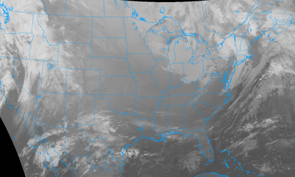
Good morning folks! A cold crisp start to the Tuesday with temperatures this morning sitting in the low 20's. Good news though, as it will turn out to be another beautiful day in east Tennessee. Highs are expected to peak out in the upper 40's for most of the area with mostly sunny skies over head. As you can see below, there is relatively no clouds in the eastern half of Tennessee. As the day progresses we may see some clouds move in, but that will mainly overnight tonight. Into tonight, lows will drop into the upper 30's with those clouds building. For Wednesday, break out that umbrella again as the rain will be back. Expect a decent amount of rain with this system with upwards of half an inch possible. Rain should continue into Wednesday night and into Thursday morning. On the tail end of this system will be a sharp cold front (similar to the one we just had a few days ago). This mean there is a chance of some snow showers late Wednesday into Thursday morning. Expect little to no accumulation (also similar to the last system). Once this system passes through Wednesday into Thursday, expect much colder temperatures. High's will be in the 30's Thursday and low 40's to finish out the work week (Friday). Follow us on twitter (@SecretCityWX), share our website (SecretCityWX.weebly.com) to friends, family, and co-workers, and as always we will keep you up to date with what weather is to come! Enjoy the beautiful day before rain returns tomorrow bringing colder temperatures.
Good Morning everyone! Big Changes in weather are in store over the next several days. To start, temperatures will be in the mid 30's as you are leaving the door and heading to work/school. Before you leave, I recommend bringing an umbrella or rain jacket as today will be wet at times. Expect showers to begin around lunch time (noon timeframe) and be spread out throughout the day and into the evening hours. As you can see below, a line of showers impact our area and are expected to mostly move out by 9 pm. Anytime after nine, showers will be widespread and relatively quick moving. As for your high Thursday, expect it to top out in the low 40's. Into Thursday evening, not much of a change as temperatures will be in the upper 30's overnight. Overall, rain totals are expected to be between a quarter and half an inch. Friday looks to be much drier as the temperatures warm up to be in the mid 50's. Cloudy skies will persist most of the day for east TN. Friday evening low's will dip into the low to mid 40's. Big Changes Into Our WeekendSaturday's system will bring lots of change into east Tennessee and the whole southern region. A low pressure system is expected to bring a strong line of rain (Possibly embedded with thunderstorms) Saturday afternoon. The timing of this system first hitting is around lunch (12-1 o' clock). Periods of rain will continue into the overnights hours before transitioning to snow showers. Rain totals can reach up to two inches! Winds are another issues associated with this system as there can be gusts between 40-50 mph at times. The reason for this is due to the very cold air trailing this system. With this in mind, be on the look out for wind advisories and other alerts put out by the NWS for your Saturday into Sunday. I will keep you up to date on here, as well as through our Twitter (@SecretCityWX). Transitioning into Sunday, it will be a cold one. Temperatures will be dropping (yes dropping) throughout the day due to the strong cold front associated with the system. Do not rule out the possibility of some snow showers Sunday. Snow amounts this weekend look dim as most areas will receive little to no accumulating (Accumulation: a tenth of an inch or more snow) snow. Due to the moisture from the rain and warm surfaces, any snow that falls is likely to melt. From the graphic below, you can see the sharp line of cold air funneling into our area Saturday night into Sunday. This is why temperatures will be getting progressively colder from Saturday night and throughout the day Sunday. Prepare Monday for the coldest temperatures of the year thus far. Temperatures on MLK (Monday) in the early morning hours will be in the teens. Adding on the wind, temperatures could feel in the mid-single digits for our area. Please be careful if you plan to be out Monday (especially Monday morning) as frostbite and hypothermia can occur quickly in these types of conditions. Monday's high across the area is expected to reach around freezing with sunny skies. If you can get through Monday, Tuesday and the days following look to be much warmer (mid to upper 40's) as a high pressure system will sit over the eastern United States. Stay up to date for the latest changes in weather through our Twitter (@SecretCityWX) and on here! Also check out our "Weekly Forecast" tab to see your highs/lows and precipitation potential in the days to come. Remember to stay dry, safe, and warm, as lots of things are happening in the days ahead.
Overnight, expect lows to bottom out in the mid 30's with cloudy skies. Into the start of the work week temperatures should be near 40 for the high. Cloudy skies will continue into your Monday as it is remanence of the rain brought this past weekend. Overnight Monday, it will be cooler with temperatures in the upper 20's and clouds moving out. Tuesday looks to be clear with highs in the mid 40's. The same can be said for Wednesday with high's around 50 and mostly sunny skies. Thursday the pattern changes as the rain returns to east Tennessee. Cooler temperatures and the possibility of some interesting weather this weekend and early next week is there so check back in with us later this week. Overall, expect a nice first part of the week with mostly sunny skies and highs near the average for this time of the year (mid 40's). As always, stay up to date here and on our Twitter (@SecretCityWX) for the latest weather, forecasts, and alerts.
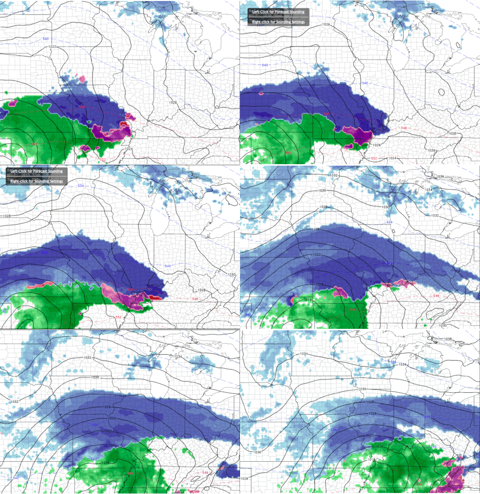
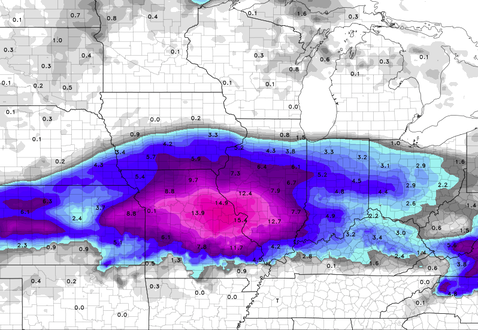
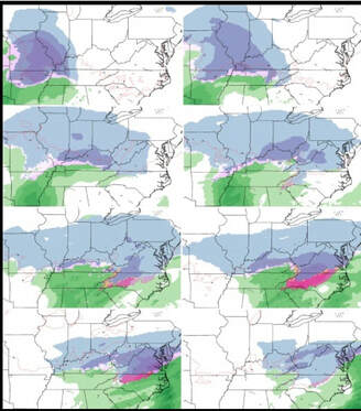
Good morning everyone! Temperatures out of the door for your Friday morning are expected to be in the mid 20's. To close out the work week, conditions will remain rather pleasant for winter with high's in the mid to upper 40's, mostly sunny skies, and light winds. Friday night's low will be a bit warmer than the previous nights with a low in the mid 30's. So what is expected for this weekend? Well, snow is out of the picture. The system, as predicted, is heading too far north for us to receive any decent chance at snow. Do not rule out though the possibility of a snow shower or two for some parts of east Tennessee (mainly the northeastern quadrant). Below is an example of a model run (NAM) showing the likely areas of snow (blue) and rain (green). The timing of when some of these rain showers could impact us will be in the mid Saturday morning hours and into the afternoon. By sunset the bulk of the system will be upon us bringing lots of rain. Rain amounts of half an inch or more total are likely for our area this weekend. The rain will continue into Sunday before clearing up early next week. If you plan to travel north this weekend keep in mind the threats of snow and messy road conditions for areas like Richmond, Lexington, Danville, and to the north. The model below shows the snow amounts for the northern half of Kentucky. For Tennessee, this may be a miss for the snow but the pattern for snow and more cold weather seems prevalent in the weeks to come. As always, continue staying up to date on our page and on our Twitter (@SecretCityWX) with your latest weather updates and forecasts.
Sources: NWS, COD Weather As far as the current conditions for your Tuesday night across east Tennessee, they seem to be relatively clear. Temperatures are currently sitting in the mid 40's with the low for most of the area bottoming out in the mid 30's. For the morning commute to school and work bundle up! Temperatures will be in the low to mid 30's with winds blowing around 10+ mph. Be on the look out for wind advisories issued by the National Weather Service as there are some already put out for Seviere, Blount, Cocke counties and counties near the Smoky Mountain Region. This means winds between 15-25 mph with gusts up to 40 mph. For your Thursday, temperatures will be a little colder with high's in the mid 30's. Thursday should be mostly sunny and clear. To finish our the work week, Friday is expected to remain clear and sunny with highs in the low to mid 40's. Diving right into it.... this is of the upper level winds in the atmosphere over the next few days. We can see at the beginning of the gif a dark red pattern across northern Kentucky. This is the front bringing in that cold polar air from our northwest along with the winds. Over the next few days (Thursday into this weekend), this cold air will be sticking around and bringing a possibility of some snow flakes into the east Tennessee area. *A further description can be found below* So what does this weekend's snow chances look like? Well... Many models indicate snow on the leading edge of the system. With cold air in place from the front coming through today, and the system impacting our area during the coldest time of the day (early Saturday morning) snow is likely. Sadly for the snow enthusiasts though, this will be quickly washed away with lots of rain behind it. Snow amounts of up to half an inch are possible for most of the east Tennessee valley. As the day Saturday picks up, warmer air and moisture from the system (Warm air advection) will take-fold and make the transition from snow to rain. Rain will be the brunt of this systems as we are expected to receive amounts of near half an inch. Overall, messy roads caused by ice and snow should not be a cause of trouble as high's Saturday are expected to be in the low to mid 40's and low's for Saturday night being in the mid 30's. Since temperatures are not expected to reach or dip below the freezing point, the chances of ice are very low for most of east Tennessee. For your Sunday into the early part of next week, the system will move out leaving mostly sunny skies and high's in the mid to upper 40's.
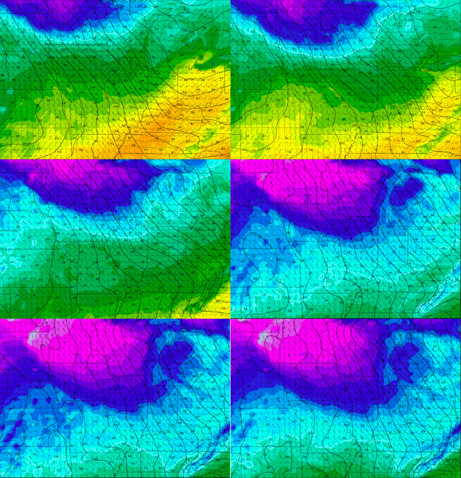
Continue to stay up to date with our Secret City Weather website and twitter (@SecretCityWX) for your latests forecasts, changes, and alerts across the east Tennessee area. Good afternoon folks! Another beautiful day in east Tennessee with temperatures in the mid 60’s and partly cloudy skies. Many changes are on the way with a cold front moving in tonight from the west. Looking at the RAP Theta-E run you can notice the plume of polar air moving into our region this evening and into tomorrow. With this change in weather, expect highs to be mainly in the mid to upper 30’s. Cold air advection associated with front will be bringing in strong winds for most of the day. This will cause temperatures to feel much colder than the true readings due to the wind chill effects. With gusts of 20+ mph possible, remember to bundle up and stay warm. Do not rule out the possibility of a stray snow shower or two for mainly the higher elevation, as the presence of some moisture is there. Overall for the east Tennessee valley, expect “Old Man Winter” to return with a blistery day. Low’s for Wednesday night should be in the mid to lower 20’s. Expect another post sometime this evening into tomorrow with talks of possibility some wintry weather this weekend. Continue checking back in for further updates on our website and twitter (@SecretCityWX).
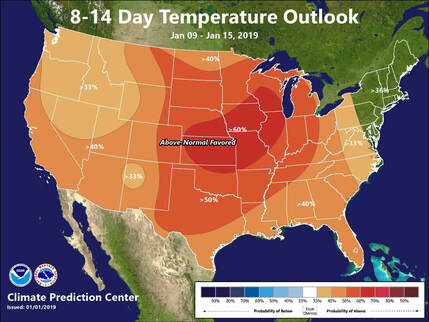
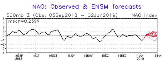
Sources: NWS, COD Weather, RAP Model The trend over the next few weeks shows average to above average temperatures for most of the continuous United States. This track is from January 9th to January 15th, 2019. So... What temperatures can you expect for the East Tennessee area? Well for the month of January, the average high is around 45° with a low of 28°. For the next few weeks ahead, expect the bulk of highs between 48°- 55° and lows mainly between 33°-40°. As for the later part of January look for cooler temperatures and the possibility of winter weather. The Knoxville, Oak Ridge, Sevierville, Clinton, Loudon and associated towns/cities average 2.5 inches of snow for the month of January. It is likely, analyzing the world oscillations, that changes in temperature for the later part of January are likely to occur, bringing cooler temperatures. As for the figure below, this is evidence that the trend for warmer temperatures over the next couple of weeks is high. The North American Oscillation (NAO) is one of many oscillations that meteorologist look at for climatic patterns. Though these are not perfect by any means, they are good guides to use when giving forecasts. High NAO values indicate higher temperatures and less chances of snow amounts over much of the mid-to southeastern US. The opposite can be said for the northeast. With high NAO values, the potential of lower than average temperatures and higher snow amounts over the course of the next few weeks is likely. Comparing the two figures, it can be seen that the northeast is expected by both models to have lower than average temperatures.
Check back in for more updates, discussions, and forecasts for the east Tennessee area! Sources: NOAA, NWS |
Your trusted source for everything weather in East Tennessee.
Social Media
|


