|
Showers end this morning, resulting in much cooler air filtering in the rest of the day. High temperatures come early, with decreasing temps thereafter. Mostly sunny skies will also move back in quick this afternoon, which will continue into Thursday as well. Check out your full video forecast below: Pre-recorded for 5pm weather broadcast
0 Comments
Those heading out this morning, be weary. Patchy dense fog has developed overnight and will gradually lift out over the next few hours. Take your time and account for some longer travel times to and from this morning. As far as tonight, the Storm Prediction Center has expanded the Marginal risk of severe storms further east. As discussed yesterday, this is because of a few stronger and longer tracking storms that could find their way off the plateau and southern Middle Tennessee. The risk remains low, but not ruled out. The main threat will be damaging wind gusts but a few isolated instances of hail will also be possible. 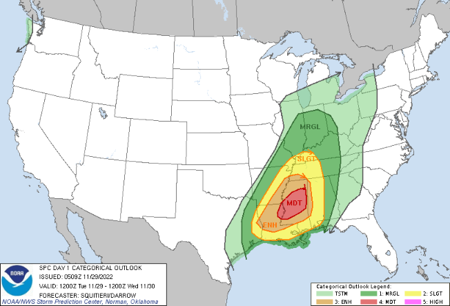 Showers will find the area later this evening, before widespread showers and embedded thunderstorms build in overnight. The primary threat locations for strong to severe storms will be the southern East TN valley and the Plateau. Storms are expected to weaken with the onset of nightfall, but a few stronger ones moving in from Mississippi could bring heavy rains, frequent lightning, and strong wind gusts. Showers will linger for the first half of the day tomorrow, before clearing overnight and into Thursday. Much cooler air will then follow for Thursday, where highs will be lucky to break the 50 degree mark.  Flash flooding is also a concern. Though we have been dry, isolated strong storms could bring heavy rainfall rates over one location and lead to flooding. Keep this in mind as well, though the risk is relatively low in total. 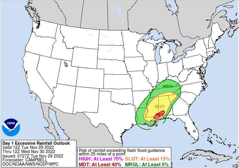 Stay tuned for alerts and know what to do if a warning were to be established- especially in the overnight hours. Have a good one and give us a follow on Twitter & Facebook for the latest alerts. You can find us at @SecretCityWx Pre-recorded for 5pm weather broadcast
I hope you are having a good start to the new work week! An active stretch is in the works, with showers and storms in the forecast. Discussing today first, cloud cover will continue thinning out through the morning, where partly cloudy skies are common this afternoon. Highs will be a little cooler today, but still mild, in the mid to upper 50s. For tomorrow, just the opposite. Partly cloudy to begin the day, then increasing cloud cover through the remainder of the day. Showers arrive late evening and overnight through Wednesday morning. The reason for the activity is because a strong cold front will be working across the area. Plenty of forcing, moisture, and lift will create a favorable environment for severe storms. Looking at the SPC outlook for Tuesday to Wednesday morning, a Moderate (4/5) risk is in place across the Lower Mississippi. Large and long lived tornadoes will be possible in these areas. Fortunately for us, these storms will weaken eastward into the night. That said, a few strong to severe storms will remain possible primarily across the Plateau and southern East TN valley. The main threat will be strong to damaging wind gusts overnight Tuesday and into early Wednesday morning. 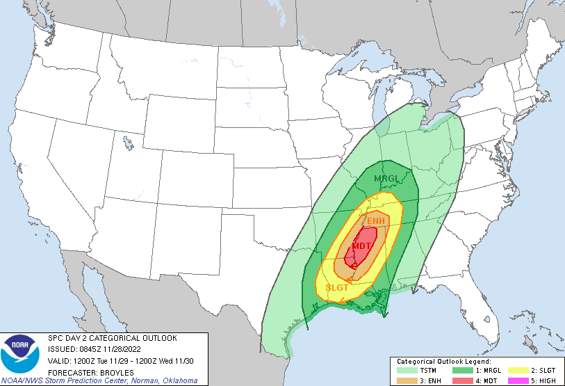 Looking at the progression of this system, it will "initiate" across the Lower Mississippi Valley tomorrow afternoon, working eastward through the evening and into the overnight. Again these storms are expected to weaken with the loss of daytime heat and energy, but that does not mean all of them will. If skies stay a bit clearer during the latter half of the day, we could see some reason for stronger storms to linger into our neck of the woods tomorrow night. Some of the higher resolution guidance depicts the southern valley could be a concern early into Wednesday morning. We will continue to keep an eye on trends and the environment moving forward, but do keep in mind a few strong to marginally severe storms will be possible overnight tomorrow and into Wednesday morning.  With thunderstorms in the mix, rainfall amounts will vary. That said, a general forecast of 1 to 2 inches can be expected through this week, where locally higher amounts are possible. Keep in mind another shot as some rainfall finds us this upcoming weekend as well. 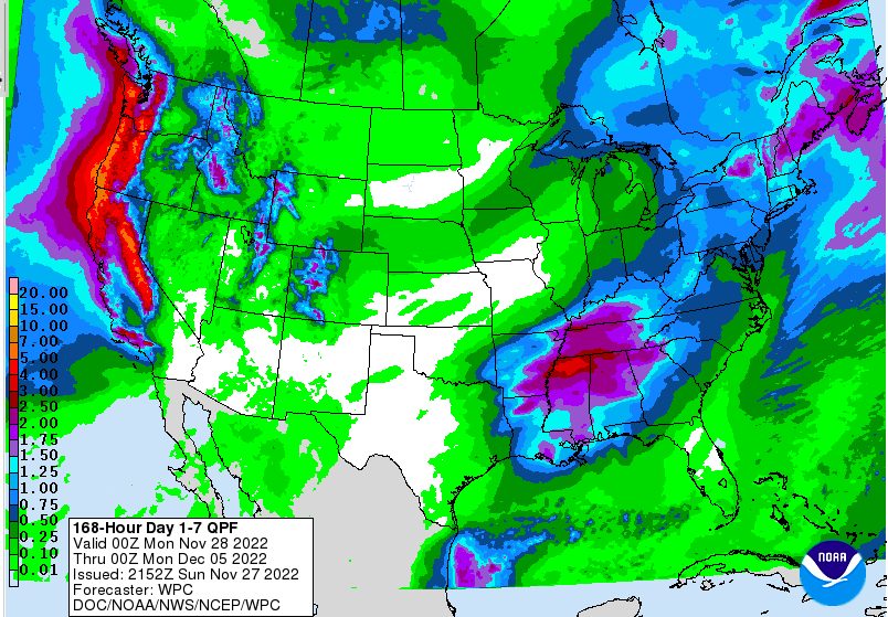 Following the cold front, much cooler air will arrive. Highs will be in the mid to upper 40s Thursday, before warming back into the 50s on Friday. Another chance for isolated to scattered showers then finds us into the weekend. Pre-recorded for 5pm weather broadcast
Some of you will gobble up this forecast: dry conditions for much of the day today! As you can see (or maybe you are still tucked away in bed) partly sunny skies have started us out. This will be the trend through noon, before cloud cover increases from west to east the later half of the day. Temperatures will be very mild for this time of the year, with highs topping out in the low to mid 60s. 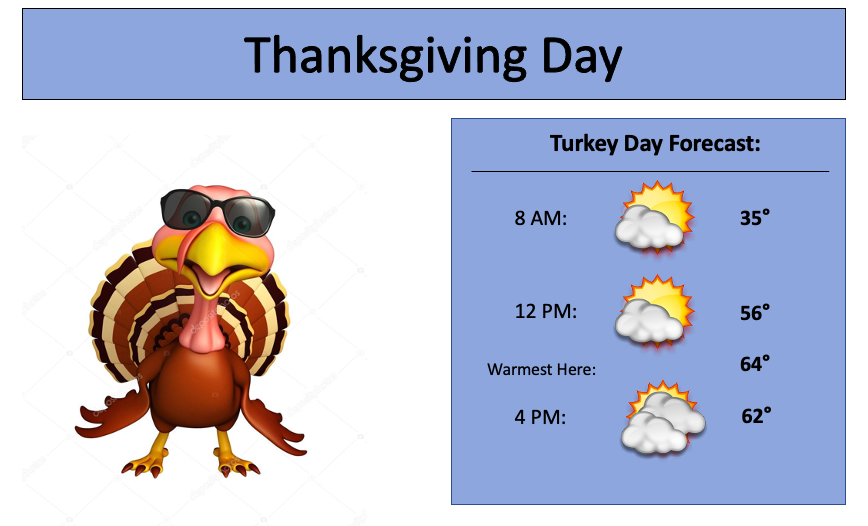 Into this evening, cloudy skies can be expected where showers will soon follow suit. A weak passing cold front will bring the chance for scattered showers into the night, where drier conditions once again return the second half of the day Friday. Butter-yet, dry conditions then continue into Saturday as well. Cloud cover will increase through the start of the weekend, as another system passes into the evening and into Sunday. This will bring widespread showers to the area, where 0.5-0.75" can be expected. High pressure then fills in Monday and Tuesday, before another system arrives and brings rainfall potential Tuesday night and throughout Wednesday.  I will quit being a ham now and get back to the forecast (I promise I am done now). The several rounds of showers will bring any where between 1 and 2 inches to East Tennessee over the next week, where locally higher amounts will be possible. We will keep an eye on the system next week, as the strength and timing still need to be worked out a bit. Nonetheless, keep the rain jackets/umbrellas handy over the next 7 days as 3 different disturbances will traverse nearby. 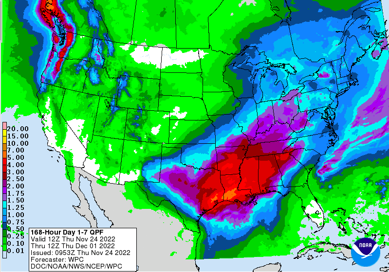 Given the dry conditions in the recent months, the several rounds of rainfall will be welcomed and hopefully puts us back on track. Temperatures overall will stay fairly seasonal in the 50s to low 60s through mid week. I hope everyone has a wonderful Thanksgiving! We will be off tomorrow but active on Twitter and Facebook, so don't forget to catch your forecast and more there by giving us a follow.
Mostly dry and seasonable now through much of Thanksgiving. Showers edge in from west to east during the evening, overspreading the area overnight and into early Friday. Another round of showers then arrives Saturday night into early Sunday, with drier conditions then following into early next week. Take a look at your full forecast by watching below: Pre-recorded for 5pm weather broadcast
After what has seemed like the start of an early Winter, near seasonal norms will work back in tomorrow. Highs today will range from the mid and upper 50s, with continued warmth pushing temps into the low (and for some) mid 60s Wednesday. Taking a look below, you can see that warmer air filling in across the Southeast.  Moving forward, a dynamic weather pattern finds us Thanksgiving evening and through the weekend. Up first, a passing cold front will bring isolated to scattered shower chances late in the day Thanksgiving, followed by a passing area of low pressure. This second system is going to be the rain soaker, where we could see amounts of over an inch in many locations. Timing is still in some what of a question, as guidance is still showing quite a bit of uncertainty. That said, I feel more confident in the arrival of the better rainfall through the day Friday, continuing into the early weekend. Drier air then fills back in later Sunday and into early next week.  Here is a look at those rainfall amounts over the next 7 days. Keep in mind drier conditions follow these passing systems, so all the rainfall will be from Thursday evening and through Saturday. The southern flank of the state is expected to see the highest amounts (1.5-2"), while the remainder of the area veers closer to the inch line. Either way, some much needed rainfall for not only the state but the region. 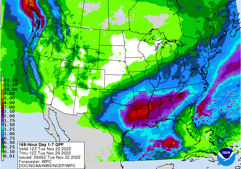 For those with Thanksgiving plans, you should stay dry most of the day. We will see showers begin to move in (west to east) toward the evening, before filling in overnight and through Friday. Pre-recorded for 5pm weather broadcast
Pre-recorded for 5pm weather broadcast
Another chilly start for many, as 11 am temperatures remain in the mid to upper 30s. As we move forward, don't expect much to change as highs stay in the 40s with overnight lows in the upper teens to low 20s through the weekend. What has changed (some) are the drought conditions. Though it may not look like it, there has been some improvement since last week, with nearly all the severe drought vanishing. There remains a few counties in the far southeast, but this should change by next week. Keep in mind these drought maps are initialized on Mondays, before going through a review process and being fully published on Thursday. This means the rainfall we had earlier in the week was not accounted for in these maps. We will see what next week map holds, but I suspect continued improvement is likely. 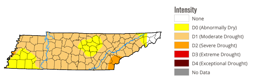 Tying the state drought to the latest 7-day rainfall/soil moisture, you can see the big changes. The aid of two passing disturbances brought a big change to soil moisture conditions (much needed). We could still use more, but this was a good start- further pushing confidence that the drought map will improve again next week. With that said, rainfall looks little to none over the next 5-6 days, so we could veer drier if rainfall doesn't arrive on or just after Thanksgiving. 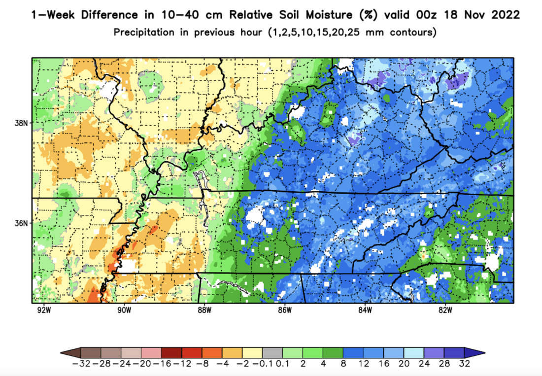 As mentioned, temperatures will remain well below average through the weekend. BUT, changes are in the forecast longer term. High pressure will reassert itself across the area by early next week, helping to boost highs back in the 50s to around 60 through the week. Generally, low 50s Monday moderating to the upper 50s by Thanksgiving Day. 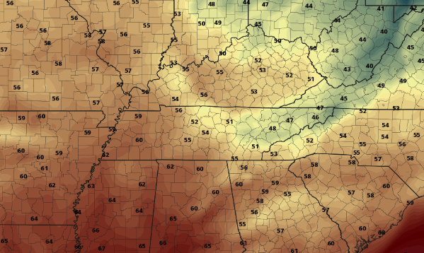 Overall, sunny to partly sunny skies and cool temperatures remain through Sunday, before a warm up much of next week. As of now, there could be a few showers arriving on Thanksgiving, but we will have to keep an eye on the timing which is a challenge pinpointing this far out. For now, stay warm and have a wonderful weekend! Pre-recorded for 5pm weather broadcast
Pre-recorded for 5pm weather broadcast
Cloud cover will linger through the first half of the day, but sunshine will continue to peak in through the late morning and afternoon. This unfortunately won't help temperatures though, as highs remain in the low to mid 40s. The trend moving forward will generally remain the same: dry, chilly, and plenty of sunshine. Looking below, well below average temperatures stay in the forecast through the end of the work week and weekend. Darker blues and purples indicate a very chilly anomaly when compared the seasonal norms. Luckily, we do have some warmer, and closer to average, temperatures returning early to mid week (next week). 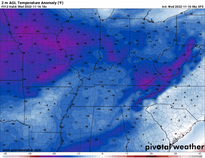 As mentioned, dry conditions will stick around for the next several days. A few passing upper level disturbances could lead to increased cloud cover at times, but overall, high pressure will shift east by the weekend. This will contribute to lots of sunshine as well as some much needed warmth. Highs should return to the 50s next week.  If you haven't already, don't forget to give us a follow so you are up to date with the latest! We are on Twitter and Facebook @SecretCityWx. Don't forget to watch our video forecast below for more information as well! Pre-recorded for 5 pm weather broadcast
|