|
Pre-recorded for 5 pm weather broadcast
0 Comments
Finally! A much needed rainfall returned late last week, bringing between 1 and 2 inches. This will greatly improve the drought conditions we have been dealing with, as most locations are in a moderate to severe drought. Additional good news: more rain is on the way this week! 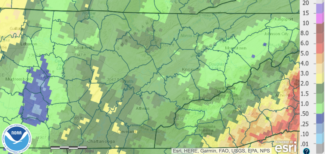 Looking at model guidance below, a series of disturbances are planning to run across the Tennessee Valley and Ohio Valley. Disturbance number one arrives tonight, where showers arrive late, continuing into the first half of the day Tuesday. This should bring a nice soaking rain of 0.25-0.5". Drier conditions then find us Wednesday, though another passing disturbance to our north could bring some isolated showers/ sprinkles and maybe some flurries later Wednesday and Wednesday night. Clearing then begins Thursday, with temperatures only topping out in the low to mid 40s. A dry cold front then passes Friday, bringing what could be near record lows Friday and Saturday night.  Temperatures this entire week will be well below average, but check out the start of Saturday morning. Most locations could see temperatures between 15 and 25 degrees below average (brrrr). Be sure to keep warm and don't forget about any outdoor pets this week. 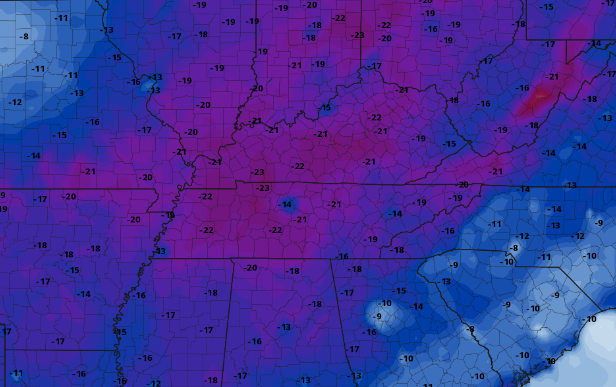 Highs today will be the warmest of the week, topping out in the low 50s, before 40s return through the weekend. The best shower chances will be tonight, but very isolated activity is possible for mainly the northern half of the area Wednesday night. Dry and even cooler weather then returns for all Thursday and into the upcoming weekend. Pre-recorded for 5 pm weather broadcast
Rounds of showers sweep through today, followed by a cold blast of air that finds us this weekend and the upcoming work week. Another disturbances passes tomorrow, bringing another chance for showers during the morning to early afternoon. Check out your full forecast by watching below: Pre-recorded for 5 pm weather broadcast
Good morning! Clear skies start off our day, but changes are quickly coming. Remnants of tropical system Nicole are working up the eastern coastline and will allow for cloud cover to overspread the area through today. This will also lead to showers later this afternoon, with chances very high by tonight. Looking at the flash flood potential, it is low. This is not a shocker, as we have been very dry the past couple of months. Nonetheless, WPC does highlight the risk, so do use caution and adhere to any potential warnings. I think this is more or less a precaution given the tropical moisture associated, and we see little issues overall. We shall see, but we will keep you posted nonetheless. 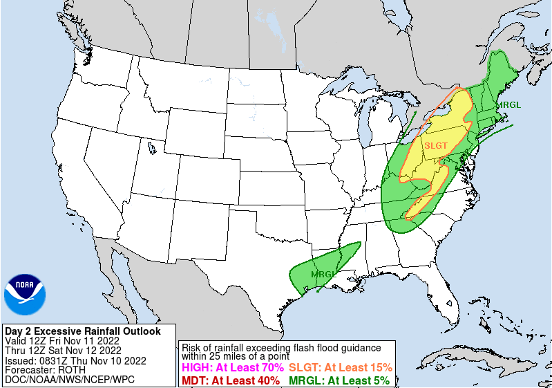 Looking at rainfall amounts with this system, you can expect somewhere between 1 and 2 inches, will locally higher amounts certainly possible. Guidance has continued to highlight (as we will see below) a swath of higher amounts associated with a sweeping cold front from the west. The combination of the approaching cold front and tropical system will bring a much needed soaking rain and then a BIG temperature change. 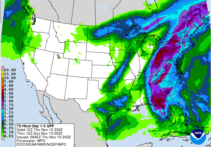 Here is the progression of the system. Showers will arrive later this afternoon, overspreading through the night and into the first half of Friday, before becoming more scattered in the afternoon and petering out overnight. Cooler air then takes hold this weekend, with gradually clearing throughout Saturday. Highs will run in the 40s and low 50s Saturday and through at least mid week. As noted, a swath/band of heavier precipitation (denoted yellows & oranges) along the front and tropical system could bring higher rainfall amounts to portions of the area.  Overall, several different things to keep in mind. Rainfall is a plus but it will be followed by very chilly airmass. A 30+ degree swing in temps will take place and this does not account for overnight lows dipping into the 20s and even teens for some locations. Be ready to exchange that raincoat for a winter one! Pre-recorded for 5 pm weather broadcast
Big changes this week: -Warm and dry through portions of the day tomorrow -A much needed soaking rain of 2-3" through Friday -MUCH cooler air Saturday and through the upcoming week (highs in the 40s and 50s) Check out the full details by watching our video forecast below! Tropical Storm Nicole continues to churn in the Atlantic, making her way westward. This system could strengthen into a hurricane as soon as tomorrow evening, before making landfall across Florida and pivoting northeast. Though this isn't good news for the already hit Florida, this will bring some much needed rainfall to our neck of the woods. 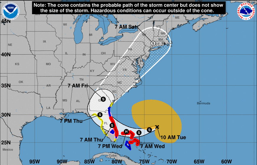 Looking at potential rainfall amounts, we could range from 0.5-1 inch. Locally higher amounts will be possible across the far east, where up to 2" is possible for some. Amounts will decrease the further west you go, with a sharp cutoff likely across the plateau and into Middle Tennessee. Like yesterday, changes remain likely, but confidence is growing better rainfall will come about with more of a westward path. Rain chances arrive late Thursday, through Veterans Day, and end early Saturday morning. 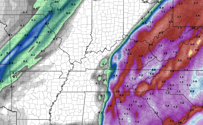 In addition to this tropical system, a strong cold front will also be sliding through the area. Following the showers late work week, very cool temperatures will find the area. Highs this weekend will range in the 40s to low 50s, with overnight lows in the 20s and even teens for some. Brace for this quick change, as we are currently in the low 70s across the area this afternoon. 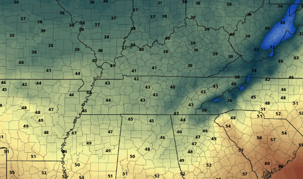 That will do it for today...be sure to check us out on Twitter & Facebook by following @SecretCityWx. Have a great day and enjoy these beautiful conditions! Pre-recorded for 5 pm weather broadcast
Good afternoon! Monday has once again returned, but so has activity in the Tropics. Tropical Storm Nicole has developed east of Florida and is expected to take a sharp left (westward) turn. This system could increase into a lower end hurricane midweek, before making landfall across Florida and bending back northeast. Eventually, this will ride the coastline, where we could see some very limited rainfall from this system. The highest probability is across the far east, where the valley and plateau see little to any chances. Time will tell, as these tropical systems are very complicated and challenging to pinpoint this far out. 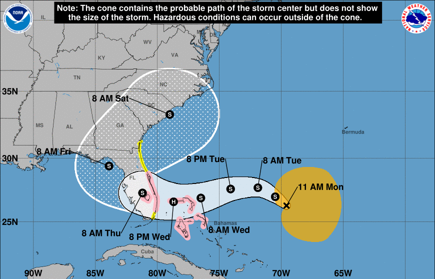 Assuming things hold as is (though changes likely), rainfall amounts will vary between up to a tenth along the TN/NC/VA border, to maybe a few one hundredths further west. Unfortunately, this will be our only rain opportunity over the next week, so count on increasing drought and wildfire concerns. Fires have already begun popping up across East Tennessee, and you can almost guarantee more are on the way. 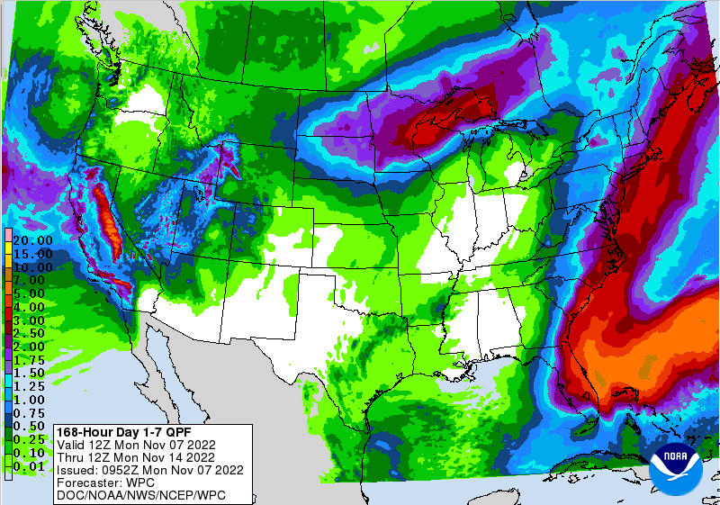 Once this tropical to sub-tropical wave works north, an upper level trough will push the system east. As it does so, MUCH cooler air will return to the region. We are near record setting highs this week, but we will quickly flip to 10-20 degrees below average this time next week. Highs will range from the 40s to low 50s beginning this weekend and continuing into at least early next week. 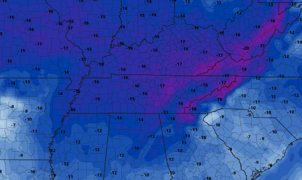 Whats that mean? Take advantage of the warm temperatures we have now because changes are on the way! This will also add another wildfire concern as chilly dry air settles in, followed by warming around 10 days for now. As always, we will keep you updated on the latest, so be sure to check in tomorrow. Give us a follow on Twitter/Facebook as well @SecretCityWx Pre-recorded for 5 pm weather broadcast
As expected, drought conditions have stayed relatively the same (minus the abnormally dry conditions now in place). There was some improvement in the west, otherwise abnormally dry to severe drought cover almost the entire state. This does not pan out well in terms of wildfire potential, as mostly dry conditions look to find us through the next 7 days. I anticipate next weeks map to worsen, with a big rain really needed across the state. 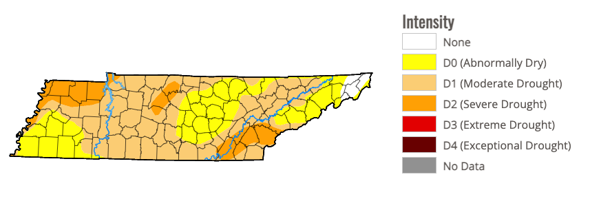 In terms of any rainfall chances, we do have a weakening cold front sliding east this weekend. Unfortunately, rainfall will be minimal, where up to a tenth is possible across mainly the plateau. Some locations in the east will be lucky to see any rain at all. This is not good for the drought we see above. Timing for this will come mainly Saturday evening and into early Sunday morning. High pressure then fills back in Sunday and early next week, drying things off and keeping temperatures warm. 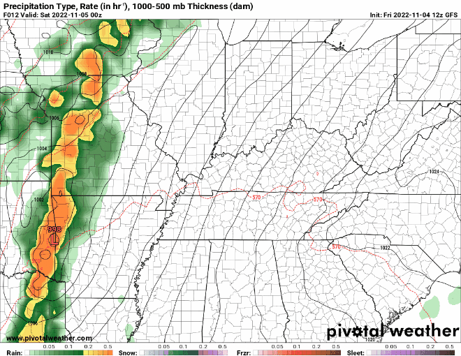 In fact, we could see a new high temperature records on Monday, as the current Oak Ridge record of 78 is in place. Our forecast calls for a 80 degree high, with potential for a couple of degrees higher in some locations. Overall, the take away is the on going well above average temperatures, minimal rainfall mid weekend, and the drought that continues to expand and worsen across the state. We will keep an eye on all of this moving forward, but wildfires could become more common in the weeks to come. Pre-recorded for 5pm weather broadcast
Sunny and warming today, with scattered high clouds building in later Friday. A weakening line of showers arrives later Saturday, bringing isolated to scattered showers. Amounts up to a tenth of an inch will be possible for some, while others have little more than a few sprinkles. High pressure fills back in later Sunday, allowing for temperatures to continue soaring into early next week. Check out our video broadcasting for more. Good afternoon! Cloud cover found us early but has since has begun to scatter out. This is the latest satellite view (noon) showing the clearing across the valley. The higher elevations will be slower to clear up, but all should return to clear skies tonight, resulting in sunshine Thursday. As far as temperatures today, most will top out in the low 70s. 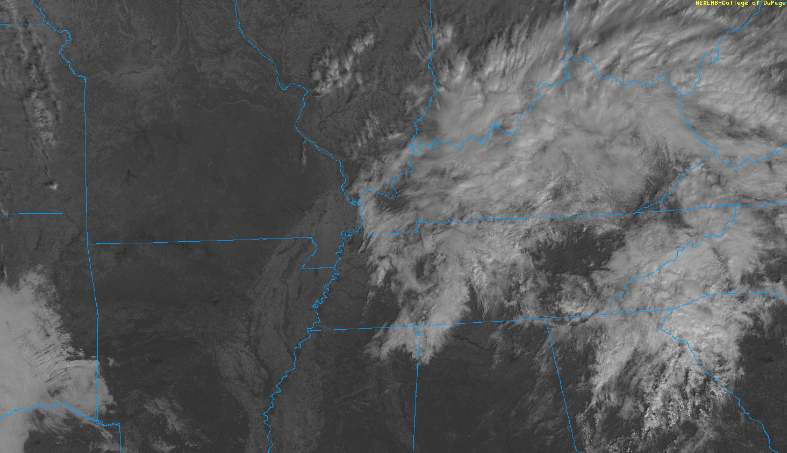 The biggest news in the most recent weeks are the dry conditions across the state. This has resulted in severe, and for a few, extreme drought. We have a very limited chance for rainfall this weekend, before another dry spell follows. Looking at the long-term outlook, things aren't pretty. Mid November will more than likely feature below average rainfall, with above average temperatures. This isn't a good sign, especially when we compare numbers to those of 2016- the Gatlinburg wildfires. We will keep an eye on things, but drier conditions will more than likely creep in over the coming weeks.  Though model guidance looks favorable for rainfall this weekend, this system will substantially weaken as it enters the state and heads east. This will result in mainly drizzle/sprinkles and isolated to scattered showers later Saturday and through Sunday. Amounts will vary from little to no rain to up to a tenth- not nearly as much as we would like. High pressure then fills back in early next week, with temperatures remaining above average in the 70s.  That will do it for today. Sunshine returns for all tomorrow, with temperatures to continue ticking upward in the days to come. Check out our video forecast below for more. Pre-recorded for 5pm weather broadcast
|